The View From Your Window Contest: Winner #228

VFYWC-228

A reader squeals:

FINALLY one I recognize at first glance! I can’t pinpoint the exact location (Google Street View is limited in the marshy/industrial areas by the Bay), but I could drive there on my way home from work. The yellow building is San Quentin Prison.

Another is thinking Reyjavik, while this one looks to mainland Europe:

Reminded me of Sète, on the southern French coast. Took a look at a couple of photos and … it’s not. Probably nearby, though!

Relatively nearby. A principled reader gets us closer:

Penzance, England. Looking eastward. I don’t think it’s fair to research these.

Another gets lost in Cornwall:

Classic VFYW: at first glance, impossible. Then, I find one clue to substantially narrow the range of my search and feel like it is within my grasp. Four hours later, it once again seems impossible.

Another thinks through the evidence:

This week’s photo really fascinates me, though I have no idea where it is, except that it’s someplace in Britain or Ireland. That’s easy enough to tell because of the double, yellow no-parking lines painted on the street, the stonework in the wall, and the fact that this place looks rather chilly. What is that white, round building anyway? A lifeguard station? Really? An old bunker for observing Nazi planes? (That would explain the observation platform on top.) What about that thing in the ocean in the right-hand side of the picture, between the rock and the lamppost – what is that? Is it really attached by a line to the aluminum pole just to the left of the lamppost or am I seeing things? If this really is somewhere in Britain or Ireland, why is the hillside on the left so devoid of vegetation?

I could go on and on. I’m really looking forward to finding out at least some of the answers to these questions.

This reader just misses the mark:

Stalwart folks enjoying the beach in cold weather, the double line, and the kerbstones scream British Isles. The color and shape of the houses is more Ireland than England, I’m thinking. Sandy beach AND rocky shore suggests north.  The shadow of the building suggests east/northeast coast. No scraggly palm trees, so not Man. Googling “cement blue bench” and “UK promenade light post” returns nothing helpful. Might be Cornwall or Wales or Scotland too. But I can’t find it so I’m hoping for proximity here. Bangor, Northern Ireland, UK?

Another hits the target by heading south:

On the “Coffee Difficulty Scale”  (the temperature of the coffee upon getting the answer corresponds to the difficulty of the window), this one scores Lukewarm.

The British influence is strong with the houses here. The double yellow line on the roadside confirms we are somewhere on the British Isles. I was pretty solid on this being either Scottish or Irish, with a possibility of somewhere in Cornwall. I almost looks like St. Ives, but without a seawall, I ruled it out. With some tinkering of search terms, I found Kilkee, Ireland pretty quickly. I could not make out any house numbers, but I think it’s either 26 or 28 Strand Line, Kilkee Ireland. Since I’m putting off raking the leaves outside, I made a picture this week:

Kilkee Ireland Contest 10-25

Now the only question is, do I stick this last half cup of coffee in the microwave, or just down it and get on with my yardwork?

For the record, it’s 26 Strand Line, but that reader nailed the right window. Meanwhile, a father feels some in-home pressure from the next generation of contest savants:

My 9-year-old son is now in the game (and playing Geoguessr on the rare occasions he’s allowed on the computer) and will soon be an force to be reckoned with. He got half way around the coast of Ireland from Dublin before I found a tipoff image under “Irish coastal towns.” Two minutes more and he would have beaten me to it.

But nobody can touch our favorite GIF-contestant, who really gives this week’s view a spin:

kilkee

A former winner really does his research on Kilkee:

Attached is the contest picture with labels for features in the scenery and directions to the statute of the late actor Richard Harris playing squash and one of the murals of Che Guevara around the town.

228 with labels

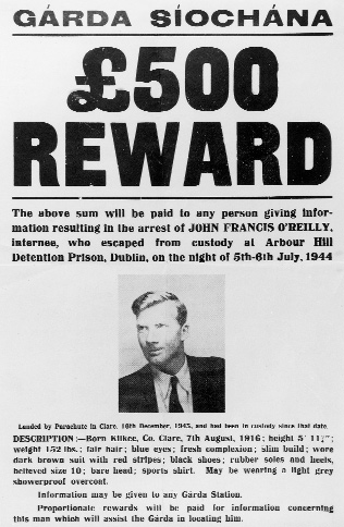
One of the features in the picture is George’s Head, the 100-foot cliff rising up from the bay on the right.  It was off George’s Head that John Francis O’Reilly claimed to have ditched the wireless set provided by his German handlers of the Sicherheitsdienst (a/k/a/ “SD”) before turning himself in to the gardaí on the night of 16 December 1943.  O’Reilly parachuted (out of a Heinkel He 111 or a Junkers JU-88 bomber) into Ireland a short distance from his parent’s home in Kilkee around 2 am and presented himself to the authorities later that evening after he learned the authorities were making inquiries.  His radio transmitter and £143 of the £300 the SD handed him were recovered in the yard of his parent’s house.  (See Terence O’Reilly’s book Hitler’s Irishmen and Anthony Kinsella’s article John Francis O’Reilly: The “Flighty Boy”).

Prior to his insertion as a German spy, O’Reilly read bulletins, poetry and other content on the Nazi’s Irland-Redacktion radio service aimed at spreading pro-German and anti-British propaganda to Irish audiences.  Given his quick arrest and subsequent military prison sentence, O’Reilly did not feed the Germans information on US and British army and navy activity in Northern Ireland as originally instructed. As for the Richard Harris statute, Harris won the Tivoli Cup for Racquets in Kilkee four years in a row (1948-51).

Another has a personal connection to the view:

I’ve tried in vain to find the location, but haven’t been successful.  The frustrating bit is the Royal National Lifeboat Institution (RNLI) lifeguard station in the picture – I thought that would help.

As an aside, I live in NYC and I am married to a Londoner.  A few months before I met my (now) wife, her mother passed away. That I didn’t get the chance to meet my wife’s mother is my great loss – by every account she was an amazing and loving person and inspired all who knew her. She was also a supporter of good works, including the RNLI. And as a tribute to this amazing woman, I make a donation to the RNLI in her memory every year on the anniversary of her death.

This Irish Dishhead is very familiar with the area:

Total time to recognise this location: 0.05 seconds. But that’s hardly surprising as I’m from County Limerick, Ireland and most people from Limerick would be able to recognise Kilkee in less than a second. Kilkee, for most Limerick folk, is like a second home. During the summer months, Kilkee becomes Little Limerick for there is scarcely a family from Limerick that doesn’t have a relative who doesn’t own or rent a mobile home (caravan or trailer) or holiday home in Kilkee where they spend the majority of their summer holidays.

Personally, I’ve been going to Kilkee since before I can remember. When I was a kid, my parents used to rent a holiday home on the West End (the exact area isn’t actually captured n the photo but the white walls on the beech in the photo is an area where people play a hybrid of tennis/squash and our holiday home was just off the Dunlicky Road just behind that. It’s common for most Limerick people to leave work on a Friday evening and wish everyone well and tell them that you’ll see them on Monday, take the 70 minute trip down to Kilkee, get a bite to eat and head of to The Greyhound Bar or Fitzpatricks Pub or Scotts Bar (or any other Kilkee pub) and wind up having a drink with half of the people they’ve just wished a good weekend to at work.

Untitled1The Dunlicky Road is very well known in Kilkee and is one of the famous walking routes in the area. The walk takes you up the Dunlicky Road over towards Intrinsic Bay (not too far away from the Diving Boards) and finally over to the Pollack Holes. It’s considered one of the best natural cures for a hangover. The Pollack Holes are natural holes that have formed in the rocks that are covered by the Atlantic during high and for six months of the year, are a breeding ground for Atlantic Pollack, but during the summer months, when the tide is out, they are one of the most populated swimming spots in Kilkee. But they’re bloody freezing at the best of times! If anyone from the Dish ever decides to visit the area, I have one recommendation: bring a wetsuit! I Googled the Pollack Holes just to see what I’d get back and came across this photo of a brave man who evidently had no fear of the cold … Christ only knows how he survived.

Springsteen played a gig in Limerick last year in Thomond Park (home to the Munster Rugby Team – “G’Wan Munster!”). During his stay in Ireland, The Boss took a trip down to bossKilkee and stopped in Scotts Bar on the Main Street (properly known as O’Curry Street) in Kilkee and the photo went viral on Facebook and twitter for all Limerick people who were raging that they missed the opportunity to get locked (drunk) with The Boss in one of Kilkee’s better watering holes (another tip for anyone planning on visiting Kilkee – avoid Miles Creeks pub – kind of a rough crowd.) [Ed note: see reader update debunking this story at the bottom of the post.]

The window I found is different from the one in Google Maps, but that could be as a result of damage caused by a storm on February 12th of this year (subsequently nicknamed “Wild Wednesday”) that battered Kilkee and other locations on Ireland West Coast including Limerick City. The main bandstand in Kilkee was practically destroyed and quite a bit of damage was done to the promenade on Kilkee beach, but the local town council did a fantastic job of cleaning the area up and repairing the damage in time for the annual summer pilgrimage of Limerick residents to the area. I’m therefore assuming that the new looking wall and window were recently installed.

Another reader has a look at the damage from the storm:

Kilkee - Blue Flag

More on the town from one of several contestants who’s been there::

Kilkee is a Victorian seaside resort in Co.Clare in the west of Ireland that was hugely popular with Irish families in the sixties and seventies before cheap flights to Spain and Portugal took them to more reliable sunshine. The small round white building is the lifeguards’ hut on the Strand Line promenade.  The absence of a small flag from the roof indicates that they’re not in residence today, or not yet anyway. The shadows show the picture was taken in the morning. The hut is one of three round shelters that were originally built to cover fleeing beachgoers from the always imminent rain. The Strand Line seawall dates from Kilkee’s Victorian heyday, when Kilkee was popular with English visitors. Charlotte Bronte visited on her honeymoon in 1854. The seawall wraps around a magnificent horseshoe-shaped beach:

418110

Sponsored Content: The Irish Tourist Board has asked me to point out that the Kilkee/Loop Head area has some truly stunning Atlantic seascapes, less well known than the Cliffs of Moher in the same county, but not as tourist-infested:

doonaha3

Kilkee is also a major centre for safe and spectacular scuba diving. And here’s Kilkee’s beach on a recent summer’s day, just as I remember it in the ’70s.  Note the cloud shadow:

x_large

Speaking of shadows, Chini admits that even he suffers from routine bouts of contest terror:

After this much time and experience, you’d think it would go away; that terrifying feeling every time a new one pops up. That a sort of confidence would have developed. But no, it’s always the same. The mad desire to look around, that growing, gnawing sense of imminent failure, and the voice in the back of the head whispering “…you may never get this one.” Then, from nowhere, a sudden insight and a realization that there was nothing to worry about at all:

VFYW Kilkee Overhead Marked - Copy

This week’s winner is a four-year-veteran who hails from our esteemed list of players who have guessed difficult contests in the past but never won:

This view shows us a day at the beach in Kilkee, a resort town in County Clare, Ireland.  The double yellow lines next to the curb suggested we were somewhere in the British Isles.  My gut told me this was probably a seaside town in Ireland, but I ignored my gut and went on an extended detour through the beaches of the United Kingdom.  Bad call.

When that didn’t work, I went down a list of beaches in Ireland and found the beach in Kilkee.  The view was taken from a one-story home on the Strand Line, a scenic street that runs parallel to the beach.

VFYW Kilkee

Kilkee has a number of claims to fame, one of which is that the actor Richard Harris used to summer there.  The town honored him with a statue of him playing squash, which was unveiled by Harris’ family and Russell Crowe.  Also, the sea wall in the background used to host (improbably) a 20-foot mural with the iconic image of Che Guevara, which would’ve been just out of view to the left had it not been painted over last year.  Guevara spent a night in Kilkee and was recognized there by the artist Jim Fitzpatrick, who went on to create the famous image.  The mural was painted over after it upset some Americans who saw it and apparently left town in protest.  It’s fair to say that either the statue or the now-departed mural would’ve made memorable clues.

Congrats on a long-deserved victory. For everyone else, get ready for the next view Saturday!


Update from an Irish reader:

We have a “Bruce Springsteen in Kilkee” controversy! Your reader was duped by a photo supposedly showing Bruce Springsteenboss-orig outside Scott’s bar in the town. This was Photoshopped. The real picture took place in New Jersey. It’s very obvious when you compare pictures which one is real. Your reader is not alone in these parts to believe Bruce visited Kilkee while he played a concert in Limerick last summer, but unfortunately there is no evidence he was ever in Kilkee.

Update from a Californian reader:

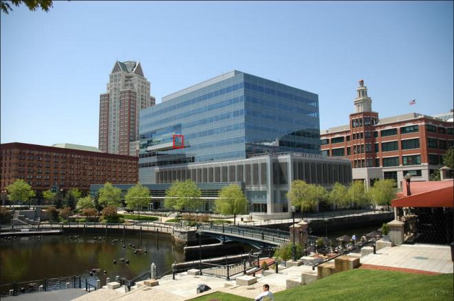
The first guess of San Quentin Prison made me laugh out loud. I had noticed the similarity as well. In case you are not familiar with that view, here’s a photo I took recently from the Corte Madera Ecological Reserve looking toward San Quentin and the Richmond-San Rafael Bridge. It’s almost like a Kilkee parallel universe:

IMG_0163

(Archive: Text|Gallery)

The View From Your Window Contest

VFYWC-228

You have until noon on Tuesday to guess it. City and/or state first, then country. Please put the location in the subject heading, along with any description within the email. If no one guesses the exact location, proximity counts.  Be sure to email entries to contest@andrewsullivan.com. Winner gets a free The View From Your Window book or two free gift subscriptions to the Dish. Have at it.

Browse our previous contests here. Also, regular players adept at using Google Earth or Satellite View should check out Yousuke Ozawa’s effort to collect an alphabet made entirely from overhead views of buildings.

The View From Your Window Contest: Winner #227

VFYWC-227

Doug Chini is pleased:

You hear that Dish team? That sharp, repeating sound? That’s the sound of a happy Chini clapping. Nicely, nicely done. No landmarks, no giveaways, no mercy. THIS is how you do a view. Don’t get me wrong, it’s not the hardest contest we’ve had (there’s almost too many clues), but it’s still a classic example of what this little slice of Internet insanity is all about.

A less-pleased contestant:

Damn. That roof seems like France, but not the rest. Trees seem Italian. Apartments, less European. Who knows? Throwing a stab with Cagliari, Sardinia.

Another describes the scene in greater detail:

European-style architecture from the era of the Industrial Revolution, but a level of run-down shabbiness that you wouldn’t find in western Europe, which says eastern Europe, Russia or former Soviet Republic, or maybe Shanghai. A crane currently building a new high rise maybe argues for the latter.

I’m guessing that one of those cars in the lower right is of former Soviet bloc make, so I’m going to take a random guess of Kiev. I can find quite a few apartment blocks of the appropriate vintage (although nothing that looks in quite such disrepair), but I’ve got nothing to narrow it down to the building under renovation with the Mansard roof and the spiky sky light.

And just as I was about to give up, I noticed the flag on the building across the street. It looks like it’s red, blue and red horizontal stripes. Laos? Doesn’t seem likely to have a city this dense. Nope, I’ll stick to Kiev. Whatever it is, at least it’s an interesting photo.

Another zooms in on the car:

OK, I give up. Based on the metal roofs, snow fences, tall buildings and the Lada in the corner of the picture, I think we’re in Moscow. Since I can’t find the buildings or window, I’ll just send in a Lada joke:

A man buys a Lada but after only one day of ownership returns it to the garage.image1
‘The car’s no good.’ says the man.
‘What’s wrong?’ asks the car dealer.
‘Do you see that steep hill over there?’ says the man, pointing. ‘Well it will only get up to 75 up there’.
‘That’s not bad really sir, especially for a Lada. I can’t see a problem with that’.
‘Trouble is,’ said the man, ‘I live at 95’.

Almost every guess this week landed in the former Soviet Union, including cities like Kaliningrad and Tbilisi. This reader returns to the most important clue:

So many clues, but unlike past challenges, this one is just out of reach.  Let’s start with the hint of a red and blue flag at the door of the building in the middle of the photo.  I wasn’t able to get a definitive hit, but the colors are typically Slavic.  (Of course,  it’s hard not to immediately conclude that we’re in Eastern Europe anyway, based on the architecture and apparent lack of recent prosperity.)  Then there’s the indecipherable script on the van to the left.  Even after zooming in I can’t tell if it’s a Latin or Cyrillic script which would have helped enormously.

So my guess is the Northern/Central Balkans.  The consistent  use of metal roofs instead of clay tile pushes us away from the southern Balkan nations, and the shallow slope of the roofs keep us from going too far north and east into snowier climates.  So my guess is Serbia, Romania or Moldova, but I can’t seem to get any more specific than that.  I’ll stick with Serbia based on the Slavic suggestion of the flag.

Identifying that flag led to the bulk of this week’s correct guesses:

You’d think a building with a curvy gambrel roof (or flagmodified mansard?) with pyramid skylights would be easy to find. Maybe, but I sure can’t. Clues were few and far between this week. The vista looked rather post-Soviet: run-down but lots of satellite dishes. Grates on the roof edges suggested someplace snowy. All that added up to any city between Harbin, China and Krakow, Poland. The single real clue I could divine was a flag on the building across the street. It looked red-blue-red to me, which is the flag of Laos, which seemed improbable. But maybe it was red-blue-orange, like the flag of Armenia.

From all the pictures I looked at, it sure did look like Yerevan, Armenia. But I still can’t find that dang building anywhere, and it’s not for lack of trying.

Dish readers have been to Yerevan, naturally:

The moment I saw this week’s VFYW contest picture I knew it was Yerevan, Armenia. I recently had the opportunity to visit that country, and as soon as I scrolled down and saw the photo I had a strong sense of deja vu. What gives it away is the mix of Eurasian, Imperial Russian and Soviet architecture. And the pink/dark stone used for many of the older buildings, which is practically uniquely Armenian (although used to a lesser extent in Azerbaijan and Georgia).

A former winner, who nearly gets the right building, elaborates on why Yerevan is known as “The Pink City”:

Pretty tough; or should I say pretty tuff? You know, there is only one city in the world whose buildings are mainly made of pink tuff [a light, porous rock formed by consolidation of volcanic ash]. This week’s picture was taken in Yerevan, Armenia, from the northwest side of this building on Teryan Street:

14th-Floor-Hotel

There is a hotel housed in the building, the 14th Floor Hotel, but – as its name clearly implies – it is located on the 14th floor, while the contest picture was taken from about the sixth floor, so I am assuming that someone hosted in the hotel sneaked into some other place in the building to shoot the photo.

A contest veteran nails the correct building – another hotel:

Thank God for the half-obscured flag of Armenia by the door of the tan building!  Armenia has the only national flag with that pattern of colors, so we have to be in Yerevan. From there it was a matter of matching the right configuration of Soviet-era housing blocks on Google Earth and finding a photo nearby showing any of the buildings in the foreground of the view.  A photo from Amiryan Street clearly shows the tan building with the obscured flag.  That building is the Yeghishe Charents School No. 67, named for the noted Armenian poet and political prisoner under Stalin:

VFYW Yerevan

Details about the rest of the area in the shot, a block away from Yerevan’s Republic Square, were frustratingly few, but there’s enough to go on to deduce that the photo was taken from the Paris Hotel at 4/6 Amiryan Street.

Another former winner adds:

Before focusing on Yerevan, the search began in Vanadzor, Armenia because the Vanadzor State Pedagogical Institute’s building looks similar to the Yeghishe Charents Basic School No. 67 in the center of the contest photo.  (No word yet on whether Armenia will be altering its naming system for elementary schools in light of the basic American meme.)  The detour was nonetheless useful.  The resemblance between the buildings indicated that the window was likely in Armenia.  As for Teryan and Charents, they were Armenian poets of some renowned.

One reader’s struggle after IDing the flag:

“This should be easy!” I thought to myself.

Wikipedia.

“Only one city of real size … Yerevan.”

Google Map.

“Bingo … all sorts of Soviet era apartment buildings. OK … quite a few. No. An amazing amount of them.”

Hours pass.

“Oh crap, I’m going to have to go block by block.”

Hours pass.

“Maybe it isn’t Yerevan. But … the flag … an embassy? That new republic of something or other …”

I was just about to go take some ibuprofen and give it another shot in the morning. But then I saw a row of buildings that looked very solid. I went through hundreds of assumptions, and none of them panned out. Eventually, brute force won out.

Another notes:

The very small image of a flag, which is barely visible, was the only clue to quickly identify the country as Armenia. This is a very poor country with wide-spread poverty which the view from the window under-scores.  Quite a contrast with Providence, Rhode Island!

The absence of Google street view for Yerevan makes identifying the precise window or address very challenging.  This montage summarizes my search process:

Montage

An incredibly detailed walkthrough:

My first impression of the scene was the juxtaposition of 20th Century shabbiness with some Second Empire / fin de siècle architecture.  I was immediately inclined to think we were looking at a former Soviet or Warsaw Pact city.  But the French feel of the old building in the foreground and the rising terrain in the background left me unable to rule out immediately a Parisian suburb or provincial cité.

image004The essential clue proved to be the flag on the building in the middle distance – a detail visible only when I enlarged it. (At first I thought the blue stripe appeared between two red ones, which led me astray for a while.)  When I recognized that the bottom stripe was orange, I knew we were in Armenia.  And presumably Yerevan, because I cannot even name another city in Armenia. But the degree of difficulty in pinpointing the window was raised significantly by the fact that Google does not provide Street View for Yerevan.  But at least some Armenians have created a less comprehensive version that allows a few street-level views.

image012

And thus we match the window’s western view …

image017

… to landmarks in Yerevan:

image007

Incidentally, a southern view from an upper floor of the same building ought to show Mt. Ararat:

image019

The building in the middle distance (labeled “B”) is the Yeghishe Charents School No. 67.  Here are some other views of it:

image008

So our photographer was looking generally west from this building or set of buildings at the corner of Amiryan and Teryan Streets:

image010

Unfortunately, because “Maps of Yerevan” has fewer still images than Google Street View, one cannot adjust slightly to see around an obstacle to find the window.  And the only street view of the northwest side of the VFYW building is this – in which the photographer’s window, overlooking the fire escape of our fin de siècle building, is obscured:

image009

And so I must resort to the most inexact of tools: a Google Earth model image:

 image013

Since the scale is distorted, I find that this is as exact as I can get.  Perhaps this is the view from Deloitte’s Yerevan office on the 3rd floor of 4/6 Amiryan, but it just as likely might be the view from the Regional Studies Center on the 4th floor.

By the way, Yerevan will forever be etched into my mind as the target city for attack in the first computer simulation I ever played (on a Radio Shack TRS-80):  B-1 Nuclear Bomber.

Only one reader nailed the right floor of the building this week, for the win:

image

Seems to be looking WSW from 4/6 Teryan St, I’m going to say the 7th floor, let’s say room 715 for kicks. Though I can’t seem to find any additional information or pictures of the building and there’s no street view.

BTW, the street numbering system seems completely arbitrary. Only clue was was the Armenian (yes that’s red, blue, ORANGE, not red, blue, red) flag on the Yeghishe Charents Basic School No. 67 and the shiny roof on the building in the view.

Congrats! From the reader who submitted the photo:

Wow!  This is great! The photo was taken from my 7th floor hotel room at the Paris Hotel in Yerevan.  I was there from Oct. 3-7.

See everyone again on Saturday.

(Archive: Text|Gallery)

The View From Your Window Contest

VFYWC-227

You have until noon on Tuesday to guess it. City and/or state first, then country. Please put the location in the subject heading, along with any description within the email. If no one guesses the exact location, proximity counts.  Be sure to email entries to contest@andrewsullivan.com. Winner gets a free The View From Your Window book or two free gift subscriptions to the Dish. Have at it.

Browse our previous 226 window view contests here.

The View From Your Window Contest: Winner #226

VFYWC-226

A frustrated reader sets the scene:

This one is going to haunt my dreams.

The trash can says “Please Don’t Litter”, so we are in the Anglophone world. The cars drive on the right, so we are most likely in North America. There is gleaming new construction in a super-clean neighborhood, with ample surface parking attached, adjacent to a more established neighborhood that is urban, but not super-dense. Also, slightly hilly. Assuming the photo was taken recently, we are reasonably far south, because everything is very, very green. So … probably the US, in a well-established mid-sized city that has seen some significant growth lately.

That type of new architecture (blocky with lots of glass and slick materials) is, unfortunately, really ubiquitous these days. I’ve seen buildings like that in Seattle, Portland, San Diego, Charlotte, Atlanta, Boston … a couple of weeks ago I passed through Tyson’s Corner, VA, for the first time in a long time, and seems like that is the entire town now. And seriously, that (apparently purely decorative) canal with the fountains in it should make this easy to find, right? Indianapolis (where we were for a gimme window a few weeks back) has one like it, but that’s not it.

I hate giving up on this, but I honestly have no idea. Just so I have something to put in the subject line, I’m going to say Atlanta, since it always seems like they’ve erected some new glass and steel monstrosity every time I go back there.

Another aims for a blue-glass city of the North:

Vancouver, British Columbia, Canada

Or waaay south?

My first reaction to the picture was Auckland, New Zealand. Just a wild guess, but saw a House Hunters International recently of a couple trying to buy a condo in Auckland and this looks similar to one of their views.

Another reader e-mails it in:

I’m resolving to enter this contest every week, even when I don’t think I have a good idea of where the photo was taken.  Too often I’ve said, “hey that looks like xxxx, but it’s probably not, so I won’t enter.”  Then it turns out to be xxxx.  That said, my entry this week is probably wrong.  But something about this photo looks like eastern Canada to me, and the English on the trash can rules out Montreal.  So I’m guessing Ottawa.

Only a fraction of contestants guessed incorrectly this week. The first of a few hundred correct guessers needed only 14 minutes from when the photo was posted:

Providence, Rhode Island, United States of America

A former resident elaborates:

This photo is undoubtedly of downtown Providence! I have long enjoyed reading the submissions and marveling at those who could identify the far flung places featured in VFYW so seeing my almost home state was a treat.

This was taken from the north side of the balcony about halfway up the GTECH building at 10 Memorial Boulevard in downtown Providence. You can see the church I grew up attending far to the right and the river with WaterFire baskets installed below. The red triangular building is home to Cafe Nuovo, which is a great (although I haven’t been in years, my parents go) restaurant.

theviewfromyourwindow2_october11

I grew up in a small town outside Providence, but my parents are professors at Rhode Island College in North Providence, so I spent a lot of time in the city. Buddy Cianci was responsible for a lot of the downtown development that took place in Providence when I was growing up and it’s hilarious to me that he’s running for mayor AGAIN. People love him. I’m not up on all the politics as much anymore (I live in DC now so we have plenty to keep up with here) but I know enough to admit that the downtown area is much more pleasant than it used to be. RI still struggles economically and a half-dozen WaterFire festivals each summer won’t fix that, but it’s a beautiful city with an incredible food scene and a lot of great art in general.

Wondering what a WaterFire basket could be? Dishheads have you covered:

I’m a master’s student studying water quality and sustainability, and I immediately recognized the floating bonfire pits of WaterFire in Providence.  In the 1990s, the city daylighted the previously covered Woonasquatucket River and installed the bonfire pits in the river as a civic art project.  During WaterFire nights, the city lights fires on the river and it becomes a center for activity in the city. It has been a huge success story for Providence and a model for other cities to rebuild and reinvigorate their downtowns.

Another gives you a look:

Fire water

The balcony overlooks the circular basin that marks one end of the Fire Water celebrations, where the city builds bonfires in metal baskets set in the middle of the Woonasquatucket and Providence Rivers.  Fire Water is the centerpiece of the renaissance of downtown Providence that occurred during the tenure of Buddy Cianci, Providence’s notorious once and future mayor.  All of the tall office buildings in the picture were built during that renaissance, in which Cianci spearheaded the redevelopment of the downtown riverscape, which had been covered over for much of the twentieth century.  It is extraordinary how much the city has changed as result of the public and private investment in the downtown. It is an amazing spectacle, truly carnivalesque, as well as a brilliant way of bringing tourists and suburban residents back into the city.

More on Cianci in a bit. A former winner notes:

It is probably not a coincidence that this view appeared on the day that “Full Light” takes place and it’s the event’s 20th anniversary. I suspect someone will submit an entry that includes this Saturday’s spectacle.

Total coincidence! And sadly no, it seems no Dish readers were there that night. But another reader is friends with the artist who created WaterFire, Barnaby Evans. Another passed along this video:

A more expert take:

I’m an architect, and at first glance all I saw were those relatively new banal buildings found in countless north American cities.  But in the hilly background were some brick and clapboard buildings that reminded me of coastal New England towns such as New London. Of course if you combine coastal New England with a spanking new Riverfront you immediately come up with Providence, Rhode Island, which in 1994 uncovered its long-buried river by removing what was euphemistically termed the “world’s widest bridge.”  An aerial view of downtown immediately shows the distinctive basin and amphitheater and that’s all that you need as the balcony of 10 Memorial Boulevard is pretty evident in photos.

Another had more trouble:

I became convinced that the view was looking out over a canal with fountains in it, and started searching based on that idea. There’s a Wikipedia page documenting US canals, which counts over 18,000 of them, although I got the impression most of those are for agricultural use.

As far as the right window, the following entry is probably the closest the contest has ever gotten to accidental modern art:

Slide1

That entrant adds, “I tried to say “Woonasquatucket” to my wife and she chortled “is that an invitation?” Meanwhile, this reader reminds us about the soul of wit:

Canal. Waterfire. Providence.

Next question.

Another submits in Haiku:

Views of Waterplace
GTECH seventh floor ca-ching!
Woonasquatucket

Some other great entries this week:

What really clued me in on this one was the bush. It’s centered in the frame, very nearly the subject of the photo. It seems to regard the viewer quizzically, “Why are you looking at me?” or rather, and more introspectively and shockingly self-aware, “Why can I see you looking at me?” And its the bearing of the bush, the very regal, upright, staid look on what I can only refer to as its ‘countenance,’ that bespeaks a soul bestirred, a corporal glove filled with a heavenly hand, the capital-D Divine, and when I thought “capitol” and “divine” I realized I was looking at Providence.

Incidentally, I was born in Rhode Island, in the town of S. Kingston, and have long loved the Blossom Dearie tune “Rhode Island Is Famous for You”:

With lyrics like:

Pencils come from Pennsylvania
Vests from Vest Virginia
And tents from Tent-esee
They know mink / where they grow mink / in Wy-o-mink
A camp chair / from New Hampshair / that’s for me.
Minnows come from Minnesota
Coats come from Dakota
But why should you be blue?
‘Cause you / you come from Rhode Island
And little old Rhode Island / is famous for you.

The following reader, as well as most of the numerous Dishheads who went to school in Providence, just needed the steeple to the far right of the image:

I took the steeple as the most useful clue.  Searches for “New England steeple” and “Connecticut steeple” were fruitless, but “Rhode Island steeple” brought me this among the first images (left-most)

steeple

This is the steeple of the First Baptist Church in America, built in Providence in 1774-75.  But there might be other U.S. steeples that are nearly identical; it is very close to a model in James Gibbs’s classic Book of Architecture from 1728.

More on the church:

The white steeple all the way on the right edge of the picture is First Baptist, as in Roger Williams’s FIRST Baptist parish in America, which, unlike their Southern component’s image nowadays, was a huge mover for religious freedom in colonial (Puritan) New England, and, not incidentally, was the great and wonderful late Rev. Mr. Gomes’s denomination (though his accents and tastes  seemed those of a High Anglican).

Another notes:

While the church was started in the 1630s by Roger Williams, the meeting house was completed in 1775. At that time the steeple was erected in three and half days and has ” survived time and hurricanes since then.” Quite amazing don’t you think!

And we learn that Brown’s grad ceremonies happen in that church:

In the far right of the frame is the steeple of the austerely beautiful First Baptist Church in America (located, appropriately enough, on the corner of Steeple St.), where I graduated from Brown University, and which celebrated its 375th anniversary last year. On that occasion, congregant David Coon composed the following:

Who are the members of the First Baptist Church in America?

We are not Southern Baptists.
We are not Jerry Falwell Baptists.
We are not Westboro Baptist Church Baptists.
Nor are we an ethical debating society.
We are followers of Jesus Christ, as study and prayer and teaching and worship lead each of us to an individual belief in what that means.

We are Roger Williams Baptists.
We are “soul liberty” Baptists.
We are “separation of church and state” Baptists.
We are a “shelter for persons distressed of conscience,” a place where everyone has the right to approach God in her or his own way.

Here, we take the Bible seriously, not literally.
Here, we worship a God who provides “minimum protection, maximum support.”
Here, we expect acceptance, not judgment – humility not hubris – laughter not gloom.
Here we listen thoughtfully rather than speak loudly.
Here, we sing – we sing praises, we sing thanks, we sing prayers, we sing because we love to sing.
Here, we honor, we truly honor, the differences of opinion among those who are reverently seeking their own way to God.

We are the First Baptist Church in America and we reserve the right to accept everyone.

Another notes that First Baptist “seems to take pride its punny sign out front (“This church is prayer conditioned”)”. Another reader has more:

Interestingly, the Providence Plantation, founded by Roger Williams in 1626, is described as “the first place in modern history where religious liberty and the separation of church and state were acknowledged.” Williams founded this church two years later. It would be interesting to hear how Williams might evaluate his own legacy in the US today, 388 years later.

He adds:

Another week where I am feeling the fleeting satisfaction from correctly discovering the view location, followed by the lingering sadness that comes from knowing that hundreds of others (many who actually LIVE in Providence, or went to Brown University, or have some other clearly unfair advantage), are at this very moment getting this week’s view correct also, and that my response will likely be put into the “correct answer collage”. I have no doubt that some reader in posession of too much leisure time as well as the building blueprints and intergalactic coordinates of the boxwood will edge me out. Oh well. At least last week’s contest was won by someone who wrote impressively about naturalized, cultivated Norway spruce trees and temperate forests transitioning to aired steppes. That guy DESERVES the book.

And you deserve a collage:

vfywc-226-guess-collage

A reader reaches a important milestone:

Man, that art history degree FINALLY paid off (well, enough to know where this photo was taken, the student loans are still a monthly burden. Mind you, I started paying them off in 1993.)  I immediately recognized the steeple of the First Baptist Church in America in Providence, Rhode Island. It looks like the view is from the GTECH Corporation building. It’s that window off the corner of the balcony jutting out riiiiiight … THERE:

7th Floor_balcony

The balcony is located on the 7th floor and it’s used for “customer demonstrations and meeting rooms”.  Beats my sad, windowless office for sure.

The architecture critics really came out of the woodwork this week:

Collectively, this photo is taken from and of several pieces of Modernist architectural banality that have stymied the civic momentum represented by the work done in Providence during the 1990s to revive downtown through traditional urban planning and architectural.  These buildings, with the GTech building being the worst offender, represent the resurgence of the “avant garde” as they bravely resisted the civic pride that was being rediscovered, via PoMo blandness, Vancouver-ish soporifics, and good ol’ Dallas-Ft. Worth office park cheap’n’boring respectively.  Fortunately, Providence still retains a great deal of its historic fabric from the late 1700s through the 1930s, so ugly junk like this is mostly the exception, not the rule.

Another:

The buildings look part of the mixed use redevelopment trend, but it also seems this is a tourist district.  It’s nice enough, and almost certainly better than the old industrial complex that was probably there 50 years ago.  But the architecture leaves me a little cold and I wish they had riffed a little more off the brick that dominates most New England downtowns.  I’m not alone in the critique – found these quotes from an article about the design before the building went up:

“The structure has no place in Providence,” said Gregory Mallane. “It really belongs in an industrial park.”

“This building is completely out of place” in Providence, said Charles Pinning, a Providence property owner. “This building would be appropriate . . . in a city that has either obliterated its history or doesn’t have any.”

Another critic takes us to city planning school:

IMG_0005

The Gtech building sabotaged what had been a really interesting experiment in architecture and urban design Providence had going for 20 years.  A new take on urban renewal that would eventually emerge as a critique of the bomb-and-rebuild modern method of urban renewal that had marred cities from coast to coast.  In the 1980s the federal, state, and city governments cooperated to bury the massive train yards between the State House and downtown, and to move and expose the two rivers that join to form the Providence River.  In doing so, 80 acres of formerly industrial land right next to downtown were opened up for development.

It got interesting when regulations were drawn up to ensure that development here would feel complementary to the existing downtown.  Above-ground parking was prohibited, and buildings had to built out to their lot lines, to create a consistent street wall and an urban rather than suburban feel.  Further, a commission was appointed to enforce these regulations and to approve the design of individual buildings.  This type of committee is certainly a potential nightmare for developers, but there was plenty of development and for a good while the commission worked surprisingly well.  From 1988 to 2002 eight large buildings were built, among them a 30 story hotel tower and a 1.4 million square-foot shopping mall.

Initially the designs were postmodern but as years passed, shaped by the Commission, the designs became less postmodern and more unabashedly neo-historic, using traditional elements without irony or distance.  Most architects and critics where lukewarm at best towards these buildings, but the public and vistors tended to love them.  It was an intriguing experiment-  what might an urban district built entirely anew at the turn of the 20th and 21st centuries look like without the reigning prohibition on designing in historic styles?  At the intersection of  Francis Street and Memorial Boulevard the experiment had achieved some real intensity, with the proximity of three buildings patterned and decorated to sharpen, rather than dull, the sense of scale of large buildings close together.

Then in 2004 the empty lot at the fourth corner of this intersection was filled by the Gtech building, a clunk of offices wrapped in a glass curtain wall that would have looked dated in 1965.

It somehow manages to feel insubstantial and leaden at the same time.  The truncated corner tower is flat-topped because no one could come up with a satisfying modern minimal spire that didn’t look cheesy.  It’s as graceful an amputation.  The designers of this building either didn’t know how to or weren’t interested in respecting the very strong, albeit newly-created, context of this very prominent intersection, not to mention the downtown beyond.  The building is twelve stories tall but thanks to its lack of lack of surface detail feels like half that.  Whereas the surrounding buildings are romantic and exuberant, playing up the urban drama of congestion and vertical space with details that allow the eye to measure height to 30 stories, the Gtech building refutes all that with an obstinate blankness.  It is as wrong for its site as if dragged in from a suburb of Atlanta or San Diego.  (Both cities I like, by the way.)

Once Gtech went up the floodgates were opened and the rest of the capitol center filled up with modern somewhat minimalist buildings, which are visible in the window view. None are as bad as Gtech.

And back to the political angle of this week’s contest:

The scene is timely at the moment as we are in the midst of a pretty amazing Mayoral election that features Vincent A. “Buddy” Cianci trying to return to the office he has had to leave twice previously due to felony convictions. He was leading in the one publicly released polled and it will be amazing if Providence voters return him to office.

Many readers covered Cianci:

“Buddy” was mayor of Providence from 1974 to 1984. He was forced to leave office after Buddy_Cianci_4_July_2009_Bristol_RIpleading no contest to an assault. He had allegedly taken a burning log from a fireplace and beaten a man whom he believed was having an affair with his wife. His wife’s name is Nancy Ann, which makes her full name Nancy Ann Cianci (say it out loud).

In 1990, he ran for mayor again. His slogan was that “Providence needs to be made love to again.” After he won, his particular form of romantic devotion was to have the dreadfully polluted Woonasquatucket River (one of the two branches of the Providence River) converted into “Riverwalk,” a series of paved bridges that is billed as “the widest bridge in the world” (on the theory that all the bridges that cross the river are part of a single bridge). He was sent to federal prison in 2002. He has served his time and will be on the ballot as a candidate for mayor in a few weeks.

So much more:

Since this is Providence, public corruption is never far away.  WaterFire opened during Vincent “Buddy” Cianci’s second stint as mayor.  And here’s a 1997 photo of Cianci in front of the redeveloped WaterPlace Park before he was arrested during Operation Plunder Domeconvicted of racketeering charges, and spent over five years in federal prison.  (According to the Solicitor General, “the government presented evidence at trial that [Cianci] and his co-defendants awarded (or caused to be awarded) municipal jobs, city contracts, tax abatements, and building-code variances in return for cash (including contributions to Cianci’s campaign fund) and other items of value.”)

Not that a prison term should ever stop someone from a life in Rhode Island politics.  Cianci is running for mayor again and, according to a recent poll, maintains a slip lead over his closest competitor.

Another provides some art history connected to Cianci:

I believe the viewer is looking in the direction of one of Shepard Fairey’s alleged first acts of political art; he was a RISD student in the ’90s. Then candidate Buddy Cianci’s face was super-imposed over a billboard advertising the Providence Zoo’s naked mole rat exhibition.

Actually, as this reader explains, Cianci was the original inspiration for Fairey’s “Obey” images:

An interesting bit of trivia: Behind the red triangular building, on the corner of N Main and Steeple cianci-obeystreets, was where Shepard Fairey began Obey Giant (or more specifically, it’s earlier incarnation of “Andre the Giant has a Posse”), which predates his famous HOPE posters for Obama. It was 1990, and convicted felon Buddy Cianci, was running for Mayor for a second time after being released from prison. He had a large campaign billboard at the foot of College Hill facing RISD, where Shep and I were both students. As part of a class assignment, Shep wheat-pasted Andre the Giant’s head over that of Cianci’s, scrawling the soon to be famous words “Andre the Giant Has a Posse” over Buddy’s reelection message.

Someone made a short film telling the story as well. Speaking of stories:

I got into a fight with my girlfriend in that little amphitheater on the left, so thanks for re-opening those wounds. At first I wasn’t sure which floor the balcony was on, so I called GTech and asked the security guy. It’s the 5th floor. (He was very confused so I told him I was planning an elaborate proposal for my girlfriend. Haha, he has no idea we already broke up.)

And a few readers have actually been to the GTech balcony in question, but only one has puked there:

Good lord do I remember this view. Late afternoon cocktail party that went on a bit too long. I found refuge and comfort on that balcony. Don’t want to mention the company’s name, if anyone there is reading this they’ll know who I am.  I assure you the box fern in the pic is a replacement.

And finally, this week’s winner is a veteran of more than 20 contests:

Time to give the novice players a chance, huh? I imagine Chini got it before his coffee got cold. This week’s window actually looks to be a glass door, leading to the balcony on the 7th floor of the Gtech headquarters. The balcony overlooks picturesque Waterplace Park in Providence, Rhode Island:

A87A73D6-E300-4E80-8077-B3AC18B98830

I found the location by doing a Google images search for condo “random balconies”. The main building the view shows up about halfway down the first screen. Interestingly, putting “random balconies” in quotes was the key. Without the quotes, the building doesn’t show up at all. Makes me a little proud of my “Google Fu”.

Not pictured is the gorgeous Rhode Island State House, just out of view to the left. In my opinion one of the most beautiful capitol buildings in the country, both inside and out:

state-house

Beautiful, and likely corrupt, it seems. As it turns out, this week’s view originated on a field trip:

As a regular incorrect guesser of the contest, I feel a bit bemused to have the photo chosen for the contest! We took URI’s full-time MBA students to visit GTECH’s North American HQ, located at 10 Memorial Blvd in Providence. I took this photo from the northeast corner of 7th floor of the building, which overlooks the Providence River. GTECH uses this balcony to host special events, and this window is the first window of that balcony. If anyone has attended a Waterfire event, they’ll know this spot.

Too bad I can’t enter a guess in the contest, because I’d nail it this week!

Instead we’ll see you for next week’s (more difficult) contest.

(Archive: Text|Gallery)

The View From Your Window Contest

VFYWC-226

You have until noon on Tuesday to guess it. City and/or state first, then country. Please put the location in the subject heading, along with any description within the email. If no one guesses the exact location, proximity counts.  Be sure to email entries to contest@andrewsullivan.com. Winner gets a free The View From Your Window book or two free gift subscriptions to the Dish. Have at it.

Browse all our previous window view contests here.

The View From Your Window Contest: Winner #225

VFYW-C-225

A wistful reader gets us started:

Priest Lake, Idaho. No good reason, except the photo reminds me of this place I love. It’s really heaven on earth. I wish I could be there now.

Another spins the globe:

Looking towards The Remarkables from Halfway Bay, New Zealand?

Another is thinking Canada:

I’m unfortunately short of time to do a thorough search. But I am living in the Okanagan area of British Columbia right now, and it sure looks like the territory around here, especially the dry bare hills. This is all assuming the U.S. flag is a red herring.

It isn’t. Another reader thinks he’s got it:

Finally something I know at a glance. It is the iconic mountain to all New Englanders, Mt. Washington. You can tell by the building at the summit. But where? Not north or south, and east is not likely since the view is blocked by Wildcat Mountain, so West we go and it seems to be at Forest Lake Rd. Where exactly? I don’t care, because it’s a beautiful day in the state of Maine and I’m going outside to enjoy that air.

Another gets us back where we belong, the American West:

I was pretty proud of myself for being correct that last week’s tree house view was in Costa Rica. This week, I may have to content myself with being correct that this lake house view is in the United States. OK, lake in the mountains. Probably not National Forest land, based on what look to be sparse settlements around the lake. The mountains are a little bit perplexing … they are shaped like Appalachians, but are relatively bare, like ranges further west. The vegetation looks more Western, too (though I am certainly no expert on this.) I can’t help but think that the key to this is the (apparent) structure on the mountain in the distance. An observatory, maybe? My best guess is the Meyer-Womble Observatory, near the peak of Mt. Evans in Colorado, but I cannot seem to find a big enough lake nearby to make sense of the view.

As Det. Bunk would say, this is a stone fucking whodunit.

Wendell Pierce, the actor who plays Detective Bunk in The Wire, was also in the movie Sleepers, which means he’s only one degree from this October-themed guess:

Any child of the ’70s and ’80s knows that spot. Camp Crystal Lake in Sussex County, New Jersey, home of the Friday the 13th films and a young Kevin Bacon’s demise.

A less murderous entry:

OK – this was a fun one. The trees looked northwestern. There was a snowy mountain, with a bump on the top that looked like a ski lift. Some scanning of Google maps revealed Schweitzer in Montana being near Lake Prend Oreile. This photo shows the top of Schweitzer and a comparable mountain range. Trying to triangulate the VFYW photo from there, it appeared Bottle Bay was the best location. And Bottle Bay Resort appears in a search for lodging:

image001

My official guess: Cabin #6 at the Bottle Bay Resort, in Sagle, ID.

Another really struggled:

I know this isn’t right, but I had to throw something out into the VFYW Contest universe after nearly five hours of futile searching.

First of all, there is the American flag. Then I focused on whatever the hell that white thing is at the top of the distant mountain. Oh Dish Team, please tell me what that thing is.  I looked at observatories, old hotels, power plants, radio towers, mansions – I couldn’t figure it out. There seems to be a stone arch bridge in the background (maybe). I googled those for a while to no avail. The only other clue was the pine tree to the left. Did I google types of pinecones to figure out what kind of tree it was? Absolutely.  Is it a Sugar Pine? I think so. They mainly grow in California, Nevada and Oregon. The biggest body of water near those is Lake Tahoe. So I picked a city on that lake, and that was as close as I got.

I am eagerly awaiting the answer to this one. I’m hoping for lots of labels so I can learn what everything I couldn’t find actually is!

Our fave entry this week:

I thought “what if it’s not a lake, but a wide river?” So I traveled down the Columbia to the ocean. Lots of scenes that look similar, but nothing matched. Snake River. Klamath. Illinois. Nothing. Nothing. NOTHING!

Then there’s this object on the top of the mountain range in the distance:

E75A8FF9-EB49-4C38-896C-5251D9D0AC79

What the fuck is that? Is it a building? A natural rock formation? A remote Mormon temple? None of the photos I looked at (and I looked at thousands) had anything like that. It sits there like a big middle finger, taunting me.

Lol. Another reader doubts the master:

I think even Chini won’t be able to pin this one done.

Not without some consternation:

You do this long enough and you start to break the views down into sub-groups. This week’s shot, for example, belongs to the “seemingly hopeless lake view” category, prior members of which include VFYWs #166, #114 and #125. These views tend to have few clues and no clear place to start searching. But once you get over the initial panic (for me this always involves running to Wyoming and looking desperately at Yellowstone Lake from every angle), the water views turn out to be surprisingly easy:

chini

Another names that lake:

I’m just going to guess Lake Chelan, WA, because we got married on a dock on the lake and it was beautiful.

The town is Manson, Washington. Even when we try to stump even our most veteran players, we come away even more impressed with the caliber of play this contest inspires. A former winner takes us to school:

The search began by identifying the large trees by the cones visible in the contest photograph. Not much help, as the naturalized and cultivated Norway spruce is widely disturbed in many, mostly Northern states. I then looked for a large body of water with significant fluctuations in water level, which is apparent on the shoreline in the photograph and in the elevated docks with ladders. I assumed it was a lake created by a dam or one that fluctuated naturally. By chance, I began in Washington State in the area east of the Cascades but west of the drier parts of eastern Washington. Lake Chelan was a prominent candidate and fortunately a Google Earth photograph had a view with landmarks similar to that of the contest.

vfyw_collage_10-4-2014

The rest was narrowing down the approximate location based on visible landmarks and searching for accommodations that might provide helpful images. The latter proved useless (at least for me). I eventually relied on Google Earth to identify the most plausible house along the most likely stretch of the lake’s northern shore.

A big clue is that large stretches of the northern shoreline have been hardened or walled while that in front of the house and visible in the contest photograph had not. Finally I found a combination of features that resembled those in the contest photograph. These are illustrated in the attached (tall trees close to house, flag pole, bush in yard sloping to lake, prominent outcrop on shoreline, floating swim platform that is gray with white trim, and dock in the same location although apparently replaced recently). My window guess simply points to that part of the house which seems most probable. This is the only position that allows a view between the large trees while also capturing the flag pole, a portion of the dock, the neighboring shoreline, and distant landmarks. I assume the window is on the second floor.

The photograph is lovely.

Another former winner submits an equally impressive entry, and he was, aside from Chini, the only contestant to nail the exact address:

Window with labels

Back in Washington State this week.  Instead of the shores of Puget Sound, we are on Willow Point looking out over Lake Chelan towards the Chelan Mountains.  Specifically, we are admiring the view out of the back of 1841 Lakeshore Drive in Manson, WA 98831.  Various online maps lacked an address for the home, but the county assessor’s office came through with a number.  The window is the large window, furthest to the west on the main floor just above the porch.  The attached picture identifies the window.

This week’s contest took time to solve.  Obviously, the American flag ruled out Canada, New Zealand or South America.  The combination of the lake, pine trees, and arid hillsides across the water focused the search on the boundary where the temperate forests of the west coast abruptly transition to the arid steppes of eastern California, Oregon and Washington.  The Cascade and Sierra Nevada ranges cause the stark differences in rainfall between west and east.  Unfortunately, I started in at the southern end of the line in the Sierra Nevada and worked my way north.  And Lake Chelan is almost at the end of the line.

As for why I ended up on Lake Chelan, the combination of the numerous private docks and the communications towers on the mountain in the distance excluded many lakes and reservoirs along the way. Only Lake Chelan, it seemed, fit the bill.

The array of communications equipment on the far hill sits atop Chelan Butte.  Also on the mountain live a herd of bighorn sheep.  In 2004, the state’s Department of Fish and Wildlife released thirty-five bighorns to repopulate the area.  Today, the state permits hunters to kill a handful of them each year (examples here and here).

Our resident neuroscientist calls this week’s view a “fairly tough one”:

fig3

The American Flag significantly constrains the search area, and the semi-arid landscape looks like various parts of the American West. The blue spruce on the photo’s right further indicates this. California can probably be excluded because draught conditions there make for much lower water levels that this lake. Similarly, the terrain is not quite as dramatic as the rockies, thereby excluding CO, it’s not as verdant as pacific NW locales like Coeur D’Alene area, and it’s not arid enough to be around Roosevelt lake near Yellowstone. Instead, the area looks a lot like the rain shadow of the Cascades, and indeed lake Chelan in WA turned up a hit based on landmarks in the photo.

Here is the heatmap of this week’s guesses:

This embed is invalid

And readers have been around there, of course:

I have two sets of fond memories of this area.  My wife was waiting tables 40 miles uplake at Stehekin Lodge in North Cascades Park back in 1986 – till she crossed the owner’s son and got fired two weeks before the season’s end.  I bailed on my job and joined her for some spectacular backpacking – even bad things sometimes work out right.  Chelan is nice, but Stehekin and the North Cascades behind it are on a whole other level.  As close to an Alaska-type remoteness as you’ll find in the Lower 48.

I also helped on a dam licensing project for Lake Chelan in the 2000s – trying to figure out how much water to release into Chelan Gorge for fish, whitewater boating, and aesthetics.  It’s a tricky situation trying to keep the lake levels good for lake tourism, hydropower, flood control, and river values.  The lake is natural, but has been raised about 20 feet.  They drop it every spring so they can handle the runoff from the mountains and then try to keep it stable for the summer so all those people on the lake can use their boat docks.  The “bathtub ring” in the photo is what gave the View away to me – I’ve spent a lot of time looking at rivers and reservoirs around the west, and knew we had to be on one of the few that are not incredibly low from the drought (most of those in California and the southwest), and had some pretty small lake level limits to work with.  The spruce in the near view and the arid cascades basalt on the far side were the final tipoffs that we were in central WA.

Here’s a video of the whitewater boaters taking on Chelan Gorge just downstream from the lake.  This is the flow releases provided for whitewater boating two weekends a year.  Might make an interesting add-on mental health break:

Of the handful of players that guessed the right building this week, our winner had the most previous entries:

This is the SSW window of the guest house/annex at 1845 Lakeshore Dr Manson, Washington, looking southeast toward sunlit Chelan Butte, late afternoon. No doubt mine is one of literally thousands of correct answers.  Savvy contestants will note the flag. OK, somewhere in the USA. I recognized Washington State right off the bat. The light vegetation on the sunlit highest peak suggests this view is somewhere along the north side of the south end of Ebola virus shaped Lake Chelan. That is Chelan Butte catching the last sun of the day and most of Lake Chelan is in shade at this time of day.

A close look at the photo shows what Google Maps IDs as Wapato Point jutting into the lake in between the window and Chelan Butte. So a bit of triangulation with Chelan Butte and the secondary peak to its west points us to the small bay at Lakeshore Dr and Willow Point Rd in Manson. The sunbathing platform is visible on Google, and its design and orientation match the photo. So this is the guest house/smaller unit at 1845 Lakeshore Dr. Which window? The one at the SSW corner, it’s the only window with a clear view to the platform given the large trees, and with the ladder of the “L” shaped dock visible in the lower left of the shot:

Screen Shot 2014-10-04 at 11.15.37 PM

Missed it by one window, but still close enough for a win – congrats! This week’s view was actually submitted by last week’s winner, who also sends this entry-like explanation:

Winning last week and now my submission this week?  #blessed.

It’s hard to look at this photo objectively because it’s a view that is so baked into my psyche.  The view is looking southwest toward the foot of Lake Chelan (Shuh-LAN), the City of Chelan and Chelan Butte looming above it. In the middle distance, barely discernible, is Wapato Point, a peninsula-type feature that juts out into the lake.  The white cut just above the lake on the right side is the state highway that runs along the South Shore of the lake.  I’ll leave it to Chini to figure out the compass vectors. [Obliged: Southeast along a heading of 134.64 degrees.]

labeled VFYW

I’m conflicted about bragging too much about Lake Chelan because I don’t want to spoil what is, without a doubt, the jewel of Washington State.  The stats themselves are pretty impressive:  It’s the 3rd deepest lake in the country (after Crater and Tahoe) at almost 1,500 feet deep, a fact made more impressive in that it is a 1/2 mile across at its deepest point with 8,000 foot mountains that rising straight up from the shore. It’s 55 miles long. The head of the lake is in the North Cascades National Park and the location of a small town, Stehekin, that is only accessible by float plane, boat or foot.  The City of Chelan, at the arid south end of the lake, sees a good amount of tourist activity (especially from Washingtonians from the wet side of the mountains looking for a respite from the rain and gloom).  Lots of wine grapes and fruit are grown in the area.  If you’ve ever eaten an apple, it was likely grown here.

The lake level is controlled by a dam near the City of Chelan.  In the fall and winter months, the water goes down about 15 feet, leaving docks and boats high and dry. The glacial run-off from the surrounding peaks fill it back up for the summer.  That’s why the ladder on the dock is out of the water. The black looking rocks on the left side of the picture show the high-water mark.  The apparatus on the floating dock is simply to keep ducks and geese from resting there and shitting.  They are prodigious shitters.

Chelan Butte is also a world-class paragliding venue.  The photo below gives you an idea of the topography, although there is about a 800 foot differential between the Columbia River and the Lake Chelan valley. The star marks where the view photo was taken:

Task3Crossing2

Another interesting fact:  In November 1945, along the white cut on the other side of the lake, a school bus plunged into the lake during a snowstorm, killing 16 (15 kids and the driver, who had just returned from the war). Here’s a newsreel about the tragedy. There’s a roadside memorial that most people obliviously drive past on their way to taste local wine.

This aerial view gives a good perspective of Wapato Point:

aerial chelan

The green orchards are either apples, cherries, peaches or grapes. Unfortunately, many of the orchards are being ripped out to put in housing developments. The village of Manson, home of the world famous Buddy’s Tavern, is tucked into the armpit of Wapato Point. The view is taken from the living room window. The street address is 1841 Lakeshore Drive, Manson Wa, although I’ll note that the Google address machine is not very good in rural locations.  Any street address in the 1840s is acceptable.

sidebyside-chelan

Thanks again!

Thanks to you, and all our players. Come back Saturday at noon for next week’s contest.

Update from the reader behind our favorite entry, who is clearly relieved to have now identified the mountain-top middle finger:

There you are, you little fucker:

EB1CAFAA-5DB8-418F-BF07-1EC80F926D11

There’s actually a bit of history behind the Chelan Butte Fire Lookout. Built in 1938 by the Civilan Conservation Corps, it was manned until 1984 and provides a 360-degree view of the area, which includes Lake Chelan, the town of Chelan, the Wenatchee National Forest and the Columbia River. I did look at Lake Chelan, among several thousand other lakes, but never found a view that looked similar enough, and there just aren’t a lot of pictures of this structure from a distance.

Ah well … there’s always next week.

See you Saturday!

(Archive: Text|Gallery)

The View From Your Window Contest

VFYW-C-225

You have until noon on Tuesday to guess it. City and/or state first, then country. Please put the location in the subject heading, along with any description within the email. If no one guesses the exact location, proximity counts. Be sure to email entries to contest@andrewsullivan.com. Winner gets a free The View From Your Window book or two free gift subscriptions to the Dish. Have at it.

Browse all our previous window view contests here.

The View From Your Window Contest: Winner #224

VFYWC_224

A reader is aghast:

YOU PEOPLE ARE MONSTERS.

Another wonders, “Are you sure you didn’t mix up the daily VFYW and contest photo?” Another gave up in about 20 minutes:

Clearly you decided to put up an easy one this week.  What with the Ents in the distance, I know I won’t be the only one to pin this down to the Fangorn Forest in Middle Earth.  I think I see the mist of the river Earwash ahead, putting us at or close to the site where Gandalf the White met the hunters. Heck, it’s as good a guess as any other.  A tree in the middle of the forest?????

Another goes for a “shot in the dark”:

Looks like deciduous trees, the coastal range, and a fog bank. That sounds like Walnut Creek, CA to me.

Or South America?

Ariau Towes, an eco-lodge outside Manaus, Brazil:

brazil

Another looks for clues:

There are a bunch of deciduous trees. That’s less than helpful. We seem to be on a mountain. I see nothing outside to help me other than that. Given that the paucity of detail outside, I chose to focus on what was inside. There’s more to work with but … yeah, not a lot. It looks like some recording equipment (headphones, cabling, something that might possibly be a sound meter), a water bottle, and a floor with interesting swirly markings. I’m sure someone will recognize the logo on the water bottle instantly, but I got nothin. Same with the floor.

Based on the trees and recording equipment, my husband guesses Tennessee. I don’t think you’d stay in North America four weeks in a row, but I don’t have a better alternative. So, we’re going with a recording studio in Tennessee. On a mountain.

It’s not recording equipment. Another reader figures out the key characteristic of this week’s view:

[I]t’s a treetop hotel, built around a tree. No doubt about it. You would think that would narrow it down – I mean, how many of those can there be? Lots, it turns out, but none that I can find with classy inlaid wooden floors. Our best guess is Dad’s: somewhere on the coast of Peru.

Which brings me to another point: this is superficially mind-bogglingly difficult. There are no landscape clues, except the unbroken vista of trees, which does little more than prove that we’re not in downtown Manhattan or Beijing. All clues have to come from the “window” itself and surrounding items.  Despite this, because you posted the contest, it follows that it must be solvable in a reasonable amount of time by a reasonably-intelligent Dish reader. Therefore, I propose the View Anthropic Principle: no matter how hard a “view” is, the fact that it is posted at all means that it is solvable with the information on hand. 

Maybe so. Just not necessarily by us, this time!

Most of this week’s guesses correctly got on the treehouse track:

This treehouse doesn’t look like the one I stayed in, but the view reminds me of some of the views while we we ziplining around in the Bokeo Reserve for three days is Laos almost four years ago.  It was one of the only times I’ve seen a jungle view that just went on and on the way it looks like this view does. I can tell this is definitely a view from a tree house so its worth a shot, right?

Here’s a view of what one of the tree houses looked like as you were sailing towards it on the zipline:

IMG_4861

Another reader is thinking Africa:

I just spent my Monday morning at work googling “African treehouse.”  I looked at lots of images, but nothing fit, so I’m guessing Botswana, mostly because it’s fun to say.

Another suggested “Youvegoddabephukingkiddingme, Thailand”. But this guess gets pretty close:

Although the foreground view is a little more cluttered than I remember it, I am fairly sure this is taken from the platform of the Canopy Tower, Soberania Park, near Gamboa, Republic of Panama. That appears to be a Cecropia tree on the right (often sloths feed there), and the view is, I think, towards the North West, overlooking Soberania Park from what used to be a U.S. military-intelligence messaging center, that has been converted into a nature observatory / hotel.

A reader nails the right country:

Wow! I can only guess about where this is, but I really want to go. We’re in an octagonal (maybe hexagonal) observation platform-like structure that appears to be built around a tree overlooking a rain forest. Apart from the forest itself, there are no telling geographic features, and apart from the structure we are in, no architectural clues. So, we need to know something about the building we are in, rather than what we are looking out at.

The structure seems well-built and well-maintained.  That, the bag on the floor to the left, the pile of rope (zip lining?) and the bottled water suggest “tourist destination”. That doesn’t narrow it down a great deal, but I’m going to go with Costa Rica. And since satellite views seem a lost cause here, I looked for treehouses in Costa Rica and found the Finca Bellavista community, which seems like the sort of place (some) Dishheads might find themselves on vacation. Plus they have a couple of structures that, while not being a dead-on match for the one here, share an awful lot of features. So even if we aren’t in Finca Bellavista, I bet we are someplace close by.

Another pinpoints the location:

Ok, so I was a bit glib last week. I promise I’ll rein in disparaging comments about the difficulty of the contest because, damn, this one is pure evil. Trees. All we can see are trees. And floorboards. But wait, we’re IN a tree. And those floorboards are pretty unique with their painted viney patterns. Just fire up the Google machine. Somebody else has stayed in this treehouse and put a picture of it on the internet. An hour of searches along the lines of “jungle treehouse resort” later, and then, there it is. These guys stayed there. One click later and I’m on the web page of Nature Observatorio, located in Manzanillo, Costa Rica.  Not too shabby for a picture of some trees.

Not shabby at all. Here’s how all the entries broke down:

This embed is invalid

Image searching was by far the most popular method for the dozens of correct guessers this week:

At first glance this appeared to be one of those impossible views that only the champ and one or two others would solve. When I realized it was a treehouse however, I at least had some VFYW-Treehouse-2search terms. After a few searches I was amazed at the sheer number of awesome treehouses that are out there. My fourth try on Google Images I used the terms “treehouse rainforest ocean” and found [the composite image to the right]. That led to this website that offers neat “glamping” places. Glamping is “glamorous camping” apparently (something I didn’t know – thanks VFYWC!).

The VFYW is the upper level of a two level treehouse in the Gandoca-Manzanillo Rain Forest of Costa Rica. You can stay there for $320.00 a night, and “all meals are hosted in the tree house and hoisted up by staff. Guests are supplied with harnesses, helmets, and gloves.”

Here’s a wonderfully specific entry:

The picture is taken from the Nature Observatorio (aka Amazing Treehouse), located in the Gandoca-Manzanillo wildlife refuge in Costa Rica (which is called the Refugio Nacional Gandoca-Manzanillo, 36, Costa Rica by Google Maps):

image1_1

The closest town is Manzanillo, which is not visible, but would be on the right side, or northeast, out of frame of the picture roughly 3km to the city center. It is taken from a hammock on the first floor (observation level) of the treehouse, facing the Caribbean Sea to its (approximate) north. The deck is 79 feet (or 25 meters) above ground, and is reachable by rope or rope elevator. There aren’t exact GPS coordinates for the Observatorio — even the owner doesn’t have them — and the only ones I found were actually for the road and beach roughly 2 km to the north.

Visible on the left of the picture (west) is the “host” tree, which is amazingly supporting the treehouse without a single screw or nail driven into it. I hope your readers will research and watch the available interviews with the owner, Peter Garcar, and read up on the location itself. His efforts and passion are truly inspiring, and the treehouse is a wonder of both engineering and natural education. I only wish I could visit and climb to appreciate its views and all it offers. To whomever made the trip and took the picture, I am envious beyond description!!!!!

This reader only needed the floor:

Okay, I was searching in Australia before, but then an image search on Google for rainforest treehouses found me the distinctive floor of this treehouse in The Gandoca-Manzanillo wildlife refuge in Manzanillo, Costa Rica. Here is the floor:

780-15-tree-house-costa-rica

Another key clue:

It was an Instafind, and shows up in first couple pages of Google image search for  “treehouse winch remote”.

A regular player takes a shot at circling this week’s “window”:

4C882427-6BB5-4782-923B-B04B0766D872

A breakdown of the exact view:

I consider the window to be the space between the exterior vertical supports that, along with the major floor beams, create the octagonal framing of the structure. The contest photograph looks across the two sets of floor boards that are lifted to provide rope access to the tree house. These were identified by comparing the vine tendril pattern in the contest photograph with those next to people about to descend or just arrive through the open floor boards:

vfyw_Costa_collage_9-27-2014 copy

Photographs taken from beneath the tree house show which floor boards are opened. The contest window is that adjacent to the more westerly of the two openings.

A previous winner makes a connection:

A few weeks ago, we were in Manzanillo, Mexico and now we are high up in the trees of the Gandoca-Manzanillo National Wildlife Refuge south of Manzanillo, Costa Rica.

Probably the best entry we got this week:

“Haven’t they broken the rules?” asked my wife when I showed up at her elbow, having found the window this past Saturday in minutes and wanting to proclaim my triumph.  She’d noted the absence of any distinguishing features in the landscape and it seemed wrong to her that I’d had to depend solely upon objects within the room to pinpoint the location.

“Rules?  In a knife fight?  No rules!” I might have said, evoking Ted Cassidy’s assertion to Paul Newman’s Butch Cassidy just prior to his being kicked in the crotch.  I knew that, apart from the one rule that requires at least part of the window frame to appear in the photo (to prove that it really is a view from a window), then nearly anything else is fair.  And this week there was really nothing in view but a vast verdure framed by a distant sea.  Great view but lacking in specificity.

So inside, then. We see climbing ropes and a winch controller, bamboo rails, a loopy painted design all over a wooden floor, a framework of cable and wire that surrounds a hole in that floor, a hole which itself appears to center on a TREE TRUNK. So we’re high up in a tree house gazing out over a jungle view.  

The design on the floor proved to be the most valuable clue, because it appeared around 150 images deep in a simple google image search using the terms “tropical” and “treehouse.”  It’s called Nature Observatorio and it’s in the Gandoca-Manzanillo Refuge in Costa Rica, suspended 25 meters up a tree in primary rainforest.  The photo was taken looking north from the lower of its two floors.  We’re told by the proprietors that guests fall asleep lulled by the exotic chatter of parrots (along with the Caribbean breezes), that they awaken in the morning to the roar of howler monkeys.

Observatorio group

Wonderfully, its Airbnb listing says that, along with internet and breakfast, its amenities include “elevator in building,” which unavoidably raises a string of philosophical questions: what parts of an elevator can be stripped away and have it remain an elevator?  If it lacks walls and floor, but consists rather of a harness, ropes, and a winch? If it dangles BELOW the building, suspended from it, is it indeed IN the building?   

IMG_8744

I’m picking at nits there, but the Observatorio comes equipped with mosquito netting, so that’s ok. Honestly, I’m ready to sign up. It look’s wonderful!

It’s hard to resist the charming enthusiasm of this happy guest, as he shows us around:

Chini felt challenged:

Well one thing’s for certain, we’re, uh, hell and gone from the Arctic. And we’re like totally in a tree-house. Now all we need to do is find the right one. Easy, no? No. Turns out, tree-houses are the new orange, and that made this hunt one of the wilder ones. India, Thailand, Brazil, Borneo, you name it, they all got in on the act. By the time I landed in the right spot, I knew more about tree-house construction than I’ll ever need to know. But that’s the VFYW contest for you; the obscure begetting the even more obscure.

This week’s view comes from the best damn hotel room any contest viewer’s ever stayed at, i.e. the Nature Observatorio in Manzanillo, Costa Rica. The picture was taken on the lowest, main platform of a multi-platform, non invasive tree house/observatory/hotel room built in 2012 and looks east-north-east on a heading of 62 degrees towards the Gulf of Mexico in the distance:

VFYW Manzanillo Bird's Eye Far Marked - Copy

This reader has traveled in the area:

We spent a month in Costa Rica and thought the Atlantic coast was much better than the Pacific side.  Less touristic and a bit more raw country, with much friendlier Ticos – it’s got that rasta-Caribbean vibe.  Manzanillo is perfectly ramshackle and laid-back, with some great small beaches, waterfalls, and mellow roads for bike riding.  And there is still plenty of tourist infrastructure.  We ate most lunches at a great French bakery / deli (Bread and Chocolate Cafe) and stayed in a couple of mid-range places on the beaches (Banana Azul and Cabinas Yemanya).  A week looking for turtles and sloths, building sand castles with the kids, or swimming in the turquoise ocean was too short – we wish we had stayed on the Atlantic side the whole month.  I’ve included a picture from the tidepools and beach near Punta Cocles, about five miles toward Puerto Viejo from the Tree House.  A great place to reread Paul Theroux’s Mosquito Coast (a favorite book of mine – made into a decent but not quite as good movie too).

IMG_0104

Our winner this week describes himself as a “long-time correct guesser, long-time suffering loser”:

An interesting clue this week.  My initial thought was that it was impossible: a nondescript view of a forest with not much else.  Seeing as how it was a beautiful day, I was thisclose to abandoning my search this week for more productive endeavors.  Before I did, I lightened the picture to bring out some of the features in the foreground.  This is what I got:

image1

A tree trunk to the left, a climbing rope, swirly designs on the floor, a backpack on a chair and what looks like the ocean on the horizon.  Typing those elements into the google machine, I had to scroll through about a page of results until I spied this:

image4

Large tree trunk, swirly floor, climbing rope, similar chair.  I found the answer before my morning cup of coffee had gotten cold.

This week’s contest view actually came from the Dish’s own Chas Danner. He writes:

My wife and I took a belated honeymoon to Costa Rica over the winter, and our stay at the Observatorio was absolutely one of the highlights of our trip. It was an unforgettable night alone in the canopy of a lush primary rainforest.

IMG_2947

And yes, you do wake up to the howler monkeys, a pack of which rolled by like a thunderstorm around 5:30am. Our only regret was that we didn’t spend more than one night. Also, Peter, the Czech engineer who dreamed up and built the treehouse, was a delightful guide and host as well as one of the coolest people I’ve ever met in any country. Here he is holding the rope as I ascended in my tree climbing harness:

IMG_2941

The View From Your Window Contest

VFYWC_224

You have until noon on Tuesday to guess it. City and/or state first, then country. Please put the location in the subject heading, along with any description within the email. If no one guesses the exact location, proximity counts.  Be sure to email entries to contest@andrewsullivan.com. Winner gets a free The View From Your Window book or two free gift subscriptions to the Dish. Have at it.

Browse all our previous window view contests here.