
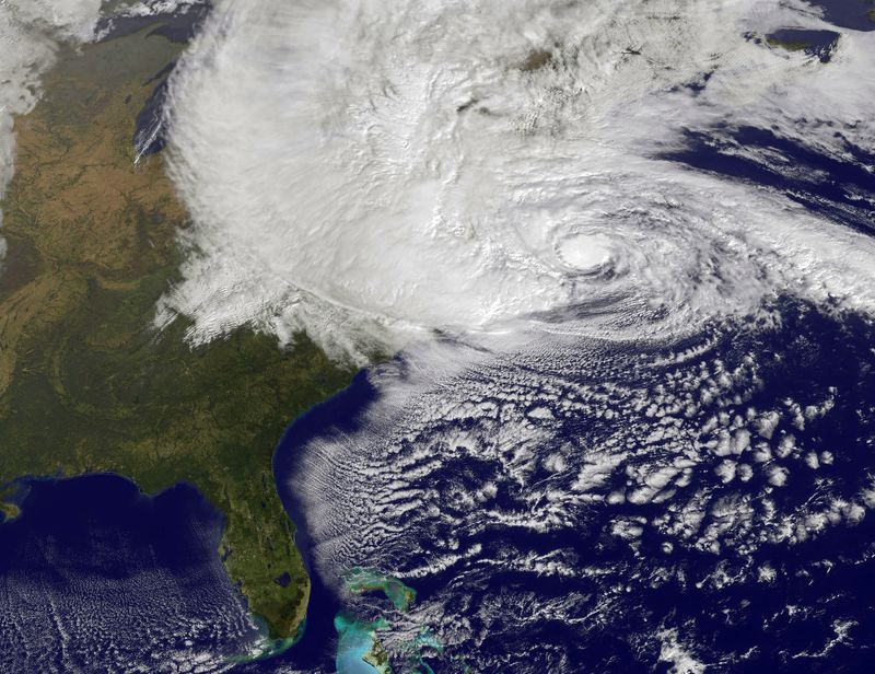
Jeff Masters analyzes new info on Sandy:
Latest data from the Hurricane Hunters shows that Sandy is intensifying as its core traverses the warm waters of the Gulf Stream. At 8 am EDT, an Air Force hurricane hunter aircraft found top winds of 98 mph in the heavy thunderstorms to the southwest of Sandy's center, at a point about 150 miles east-northeast of Cape Hatteras, NC. A dropsonde released in the eye measured a central pressure of 945 mb, but observed winds of 19 knots at the surface, so Sandy is probably a 943 mb hurricane that is very close to Category 2 strength. The Hurricane Hunters did not observe an eyewall, and saw very little temperature difference from inside to outside the eye, so Sandy is not going to be able to undergo rapid intensification. The storm could still see an increase of 5 mph in its winds before landfall tonight between 6 pm – 10 pm EDT, due, in part, to interaction with the low pressure system to its west that is pulling the hurricane towards the coast. The new, higher winds of Sandy don't have a lot of time to pile up additional storm surge water, so the NHC storm surge forecasts will probably not change today. But it is clear that Sandy is not going to pull its punch, and this superstorm is going to deliver a punishing multi-billion dollar blow to a huge area of the Eastern U.S.
Bryan Norcross' take:
At the coast, by far the worst of this is going to come at high tide at the Jersey Shore and points north. The tide will peak along much of the Northeast coast around 9PM and 9AM, but around noon and midnight on the ocean side of Cape Cod. The difference between low and high tide can be 3 feet and more… a really big deal. In a normal hurricane you can get lucky… the storm can come in at low tide, and then it's gone by the time high tide comes around. But in this case, the water will be high for a number of tide cycles, so there doesn't seem to be a way to avoid the full impact of the surging, smashing water and waves.
Waves of 10 to 20 feet on TOP of the storm surge and the tide are forecast for the south-facing beaches of Long Island. This will likely be the highest water and the most damage in many decades.
He also says that high rises "in the big cities may be a problem":
It's especially important that you stay away from the windows. If something flies off a neighboring building, it can smash windows downwind. Besides that, the wind is stronger because you're higher in the air, and the air gets squeezed between the tall buildings. The high wind stresses the glass, and makes it break more violently if something hits it.
The NYT is live-blogging the storm. Harry Enten breaks down what various regions should expect. Other updates from The Guardian here.
(Image: Hurricane Sandy, pictured at 1440 UTC, churns off the east coast on October 29, 2012 in the Atlantic Ocean. GOES satellite image by NASA via Getty Images)
