A Split Decision? Ctd

Kornacki previews the GOP response should Obama lose the popular vote but win the Electoral College:

The bad news is that Republicans probably won’t behave as if he’d been legitimately reelected. The nature of his victory would become a constant talking point. The right would be able to easily convince itself that it had won the great argument of the last four years and that Americans had validated Republican resistance to Obama, who’d been saved only by a technicality. The same pressure to oppose Obama on everything, always that has resulted in unprecedented obstruction by congressional Republicans would persist.

Of course, that obstruction will probably persist even if Obama wins the popular vote. If modern political history has taught us anything, it’s that the Republican base doesn’t believe any Democratic victory is legitimate, and always finds a way to treat a Democratic president as a usurper.

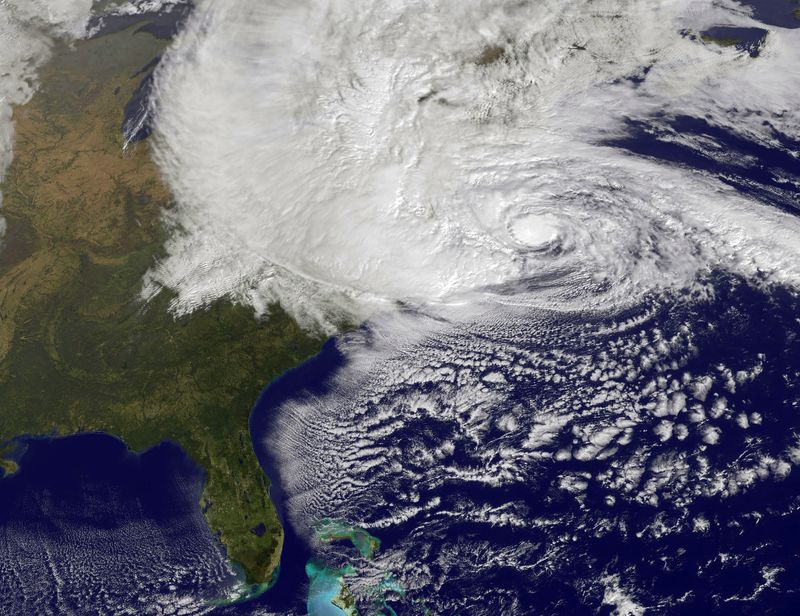
Nate Silver notes that certain analysts have theorized "that the storm could depress turnout along the Eastern Seaboard on Election Day itself." Since the storm is mostly hitting blue states, Sandy could "reduce Mr. Obama’s national popular vote without hurting his standing in the Electoral College much, potentially increasing the risk of a split outcome." But there is reason to be skeptical:

First, the Northeast is a wealthy party of the country, and wealthier regions have better infrastructure than impoverished ones, allowing them to recuperate more quickly after a disaster. Were the hurricane expected to hit at the same time next week, it would almost certainly be profoundly disruptive to the election. But the effects might be more modest a week from now.

Second, although the storm surge represents the most immediate threat from the hurricane, inland areas are under considerable risk as well. Hurricane Sandy could potentially flood riverbanks and other low-lying areas, both because of the storm surge carrying forth into them and then because of the potential for large amounts of rainfall. Moreover, these inland regions may be less well prepared to deal with the storm’s effects, especially given the news media’s tendency to focus its alerts on the impact to major, coastal cities and then to ignore the impact of a storm once it passes through them. (Hurricane Irene in 2011 produced more deaths in landlocked Vermont than in New York City.) Thus, Sandy’s after-effects could be felt in red-leaning areas like central Pennsylvania and West Virginia, along with others that are more Democratic-leaning.

Frankenstorm Update

Sandy_29th

Jeff Masters analyzes new info on Sandy:

Latest data from the Hurricane Hunters shows that Sandy is intensifying as its core traverses the warm waters of the Gulf Stream. At 8 am EDT, an Air Force hurricane hunter aircraft found top winds of 98 mph in the heavy thunderstorms to the southwest of Sandy's center, at a point about 150 miles east-northeast of Cape Hatteras, NC. A dropsonde released in the eye measured a central pressure of 945 mb, but observed winds of 19 knots at the surface, so Sandy is probably a 943 mb hurricane that is very close to Category 2 strength. The Hurricane Hunters did not observe an eyewall, and saw very little temperature difference from inside to outside the eye, so Sandy is not going to be able to undergo rapid intensification. The storm could still see an increase of 5 mph in its winds before landfall tonight between 6 pm – 10 pm EDT, due, in part, to interaction with the low pressure system to its west that is pulling the hurricane towards the coast. The new, higher winds of Sandy don't have a lot of time to pile up additional storm surge water, so the NHC storm surge forecasts will probably not change today. But it is clear that Sandy is not going to pull its punch, and this superstorm is going to deliver a punishing multi-billion dollar blow to a huge area of the Eastern U.S.

Bryan Norcross' take:

At the coast, by far the worst of this is going to come at high tide at the Jersey Shore and points north. The tide will peak along much of the Northeast coast around 9PM and 9AM, but around noon and midnight on the ocean side of Cape Cod. The difference between low and high tide can be 3 feet and more… a really big deal. In a normal hurricane you can get lucky… the storm can come in at low tide, and then it's gone by the time high tide comes around. But in this case, the water will be high for a number of tide cycles, so there doesn't seem to be a way to avoid the full impact of the surging, smashing water and waves.

Waves of 10 to 20 feet on TOP of the storm surge and the tide are forecast for the south-facing beaches of Long Island. This will likely be the highest water and the most damage in many decades.

He also says that high rises "in the big cities may be a problem":

It's especially important that you stay away from the windows. If something flies off a neighboring building, it can smash windows downwind. Besides that, the wind is stronger because you're higher in the air, and the air gets squeezed between the tall buildings. The high wind stresses the glass, and makes it break more violently if something hits it.

The NYT is live-blogging the storm. Harry Enten breaks down what various regions should expect. Other updates from The Guardian here

(Image: Hurricane Sandy, pictured at 1440 UTC, churns off the east coast on October 29, 2012 in the Atlantic Ocean. GOES satellite image by NASA via Getty Images)

Will Pollsters Get Sandy In Their Eye?

Mark Blumenthal looks into how the storm may affect polling crack:

As reported by The Huffington Post on Friday, pollsters conducting national surveys will have to decide whether to continue calling this week if, as estimated, power outages and other disruptions affect upwards of 10 million Americans. The Gallup organization "will most likely suspend all of our national tracking if we feel the representativeness of the data in the Middle Atlantic and Northeast is likely to be compromised" by the storm, according to Gallup Editor-in-Chief Frank Newport. Via email, Newport reports that Gallup "will make a final decision later this morning."

As forecasts tracked a likely landfall for Hurricane in New Jersey, observers noted that the Garden State is home to the corporate headquarters of a number of pollsters, including Gallup, Rasmussen Reports, SurveyUSA and Princeton Survey Research Associates International (PSRAI), a call center that conducts interviews for the Pew Research Center, among other clients. However, pollsters that use live interviewers typically locate their calling facilities apart from their corporate offices. Gallup, for example, maintains call centers in Nebraska, and PSRAI's main calling facility is located in Stafford Virginia.

Sandy’s Politics, Ctd

GT_OBAMASANDY2_121029

Like John Sides, John Allen isn’t worried about the hurricane’s effect on early voting. More generally:

Does Obama have a natural advantage because he’s president? The short answer: yes. The longer answer: not if he makes an unforced error. While George W. Bush’s response to Hurricane Katrina ranks among the worst blunders in modern presidential history, it has also ensured that no president or candidate will under-react to the threat of a devastating natural disaster. As president, Obama’s best politics are to simply do his job well. On Sunday, he visited the Federal Emergency Management Agency’s headquarters for a briefing, which is pictured prominently on the White House website. The president, in suit and shirt with no tie, sits between FEMA Administrator Craig Fugate and Deputy Administrator Richard Serino.

Garance Franke-Ruta notes Romney’s primary debate comments on disaster response:

Mitt Romney said America shouldn’t be in the business of providing federal disaster relief and that it would be better for the Federal Emergency Management Agency’s functions to be handled by individual states or even the private sector. Queried directly on the topic by CNN’s John King during the June 13, 2011 Republican presidential primary debate at Saint Anselm College in Manchester, New Hampshire, Romney said the federal government “cannot afford to do those things without jeopardizing the future for our kids.”

Josh Marshall parses these comments:

Many things that Romney said back during his severely conservative period I have little doubt are what he really believes. This one though is so nonsensical that I’d chalk it up more to his penchant for pandering and lack of character. But that’s a difficult excuse for Romney to use on his behalf and I suspect we’ll be hearing more about this pretty soon.

Meanwhile, Scott Bomboy examines a 2007 study called “The Republicans Should Pray for Rain,” which found that Republicans benefit from inclement weather:

[W]hile the study focuses on the effects of foul weather on Election Day, it could be instructive as to voting patterns on November 6th, when millions of people could likely be dealing with power outages, storm damage and obstructed travel conditions. The gist of the findings from three major universities: “When compared to normal conditions, rain significantly reduces voter participation by a rate of just less than 1 percent per inch, while an inch of snowfall decreases turnout by almost .5 percent. Poor weather is also shown to benefit the Republican party’s vote share.”

One big reason:

“Individuals low in socioeconomic status simply find it more difficult to bear the costs of voting, which includes both decision costs and the direct costs of registering and going to the polls,” the researchers said.

Bomboy also notes that electronic voting machines are “another wild card” in states that are disproportionately reliant on them, such as Virginia and Pennsylvania.

(Photo: President Barack Obama talks to workers after a briefing on Hurricane Sandy at FEMA Headquarters on October 28, 2012 in Washington, D.C. By Dennis Brack-Pool/Getty Images)

Quote For The Day

"IF YOU ARE RELUCTANT [TO EVACUATE], THINK ABOUT YOUR LOVED ONES, THINK ABOUT THE EMERGENCY RESPONDERS WHO WILL BE UNABLE TO REACH YOU WHEN YOU MAKE THE PANICKED PHONE CALL TO BE RESCUED, THINK ABOUT THE RESCUE/RECOVERY TEAMS WHO WILL RESCUE YOU IF YOU ARE INJURED OR RECOVER YOUR REMAINS IF YOU DO NOT SURVIVE." - The National Weather Service in New Jersey yesterday, not messing around.

(Hat tip: Andrew Kaczynski)

Sandy’s Politics

Hurricane_Sandy

There is reason to think Hurricane Sandy will hurt the president's reelection chances:

"The pretty strong pattern turns out to be that all other things being equal, the incumbent party does less well when it's too wet or too dry," says Larry Bartels, a professor of political science at Vanderbilt University. In 2004, Bartels and his then-colleague Christopher H. Achen, who's now a professor at Princeton, authored a study on the impact of climate on elections. According to their study, Al Gore lost an estimated 2.8 million votes to George W. Bush in certain states because of drought or excessive rain. These are votes, the study dryly points out, that Gore could have used.

But other research suggests that official responses matter:

We find that electorates punish presidents and governors for severe weather damage. However, we find that these effects are dwarfed by the response of attentive electorates to the actions of their officials. When the president rejects a request by the governor for federal assistance, the president is punished and the governor is rewarded at the polls.

John Sides doubts that "early voters who are stymied by Sandy would then fail to vote later on, including on Election Day":

I don’t think this is likely. What the literature on “convenience voting” suggests is that measures like vote-by-mail and early voting tend to make it easier for habitual voters to vote, rather than stimulating turnout from marginal or infrequent voters.

Nate Cohn suspects that Sandy is worse for Romney:

The clock is ticking for Mr. Romney and Hurricane Sandy probably won't help. Yes, Sandy will interfere with GOTV efforts and television advertisements in Democratic-leaning stretches of northern and eastern Virginia, but the media will be distracted from the race and Romney will be denied crucial time to mount a comeback.

And Ed Kilgore notes that power outages could stop "tens of millions of dollars worth of political messages" from being received.

(Photo: Water floods a street ahead of Hurricane Sandy on October 29, 2012 in Atlantic City, New Jersey. Governor Chris Christie’s emergency declaration is shutting down the city’s casinos and 30,000 residents were ordered to evacuate. By Mario Tama/Getty Images)

The Frankenstorm Cometh

Sandy from space

Jeff Masters puts Hurricane Sandy in perspective:

Massive and dangerous Hurricane Sandy has grown to record size as it barrels northeastwards along the North Carolina coast at 10 mph. At 8 am EDT, Sandy's tropical storm-force winds extended northeastwards 520 miles from the center, and twelve-foot high seas covered a diameter of ocean 1,030 miles across. Since records of storm size began in 1988, only one tropical storm or hurricane has been larger–Tropical Storm Olga of 2001, which had a 690 mile radius of tropical storm-force winds when it was near Bermuda 

Masters notes the biggest threat will be from the storm surge:

[NOAA analysis suggests] the destructive potential of the storm surge [will be] exceptionally high: 5.7 on a scale of 0 to 6. This is a higher destructive potential than any hurricane observed between 1969 – 2005, including Category 5 storms like Katrina, Rita, Wilma, Camille, and Andrew. The previous highest destructive potential for storm surge was 5.6 on a scale of 0 to 6, set during Hurricane Isabel of 2003. Sandy is now forecast to bring a near-record storm surge of 6 – 11 feet to Northern New Jersey and Long Island Sound, including the New York City Harbor. While Sandy's storm surge will be nowhere near as destructive as Katrina's, the storm surge does have the potential to cause many billions of dollars in damage if it hits near high tide at 9 pm EDT on Monday. 

Masters gives "a 50% chance that Sandy's storm surge will end up flooding a portion of the New York City subway system." Stu Ostro emphasizes Sandy's size:

That gigantic size is a crucially important aspect of this storm. The massive breadth of its strong winds will produce a much wider scope of impacts than if it were a tiny system, and some of them will extend very far inland. A cyclone with the same maximum sustained velocities (borderline tropical storm / hurricane) but with a very small diameter of tropical storm / gale force winds would not present nearly the same level of threat or expected effects. Unfortunately, that's not the case. This one's size, threat, and expected impacts are immense.

Mike Smith adds his forecast to the mix:

Landfall in NJ or Delaware. Winds capable of causing power failures extend from around Portland to Richmond and inland to Harrisburg and, perhaps, Buffalo. Wind gusts of 70 mph develop around DC and Baltimore.  Wind speeds are increasing throughout the eastern Great Lakes region.  The barometric pressure at landfall looks like it will be around 940-942 millibars. The storm from there moves inland and gradually weakens but may still cause gusts above 50 mph over the eastern Great Lakes region. 

Mayor Bloomberg has already ordered mandatory evacuations for some 375,000 people living in the low-lying areas of New York City known as Zone A (map here). New Jersey's evacuations are here. NYC's public transit system will also be shut down starting tonight – full list of metro-area transit closures here. The city's emergency updates can be found here. NYT live-blog here. The Guardian's round up of today's storm news is here. Hurricane tips, posted on the Dish during Hurricane Irene, can be read here.

(Photo: NOAA's GOES-13 satellite captured this visible image of the massive Hurricane Sandy on Oct. 28 at 9:02 a.m. EDT. Credit: NASA GOES Project, via NASA Goddard Photo and Video)

Man-Made Natural Disasters

Bill McKibben sees Hurricane Sandy as a window into "what the future may be like, as more and more of the world finds itself facing ever more frequent assaults from the amped-up forces of the not-so-natural world":

You can’t, as the climate-change deniers love to say, blame any particular hurricane on global warming. They’re born, as they always have been, when a tropical wave launches off the African coast and heads out into the open ocean. But when that ocean is hot—and at the moment sea surface temperatures off the northeast are five degrees higher than normal—a storm like Sandy can lurch north longer and stronger, drawing huge quantities of moisture into its clouds and then dumping them ashore.

Where Will Sandy Hit?

Sandy_Hurricane

Jeff Masters analyzes the latest weather data on the storm:

The latest set of 00Z (8 pm EDT) and 06Z (2 am EDT) computer model runs still have wide differences in the timing and landfall location for Sandy. The ECMWF has been very consistent in its handling of Sandy, and continues to predict that Sandy will hit Delaware or Maryland on Monday afternoon–basically the same forecast it has had for three days. Our other top model for forecasting hurricane tracks, the GFS, has been more inconsistent, and predicts a landfall on Long Island, New York on Tuesday afternoon. 

Harry Enten adds:

Where the storm hits, it's going to be very bad. A more indirect hit will lead to harsh conditions and potential power outages, yet it probably won't be something that is the be all, end all. That said, we don't know where the direct hit will be, so it's important to take all necessary precautions.

Image from the NOAA.