The View From Your Window Contest: Winner #155

Screen Shot 2013-05-24 at 6.18.25 PM

A reader writes:

We’ve crossed that bridge several times on our way from Paris to a small village in SW France where we like to stay. Beautiful. Just got back from NYC, so didn’t see this until this morning. If the 12 noon deadline is eastern time, I missed it.

Another:

Beylerbeyi, Turkey? That’s the Bosphorus Bridge that connects Europe and Asia.  I’m just guessing that the pic is from the Asian side.

Another:

Istanbul? I’m only making this guess because of the bridge in the background, which I think might be the Bosphourus Bridge.  Looking at a map of the area, I would guess this picture is taken from the Symbola Bosphourus Hotel.

Another Istanbul guesser:

This is as far as I’m going to get.  It’s taken from the European side, north of the Fatih Sultan Mehmet Bridge. But I’ve spent altogether too long on this, and I can’t get good enough resolution on Google Earth to figure out exactly where. First time try.  I’m betting that you’ll have lots of correct results on this one.

Another:

Hong Kong? I believe that’s the Tsing Ma Bridge in the background.

Another:

I suspect this one was too easy, if for no other reason than I was able to get a view for the first time. The bridge looked a lot like the second and newer Narrows Bridge near Tacoma, WA, but the first bridge wasn’t in the picture and nothing else matched. I looked up the list of suspension bridges on image004Wikipedia, considered and rejected the Mackinac Bridge and one of the Bosporus Bridges in Turkey, and then took a closer look at the third bridge of the right color and style and saw that it had Chinese writing on the crossbar which was also visible (though previously unnoticed) on the view.

Then it’s just a matter of looking at the Jiangyin Bridge on Google Maps, confirming the view (which took seconds), and then trying to narrow down the exact window. It looks like it’s on the property of the Huangjia Sheraton Hotel, in Jiangyin, Jiangsu, China. It almost looks like the view is too close to be in the main body of the hotel, which could place it on the wall that extends from the building, but it also looks to be above ground level so I’m going to say it’s in the hotel but zoomed in to foreshorten the view. I can’t find a map of the hotel itself and so from there it’s a guess. Let’s say 4th floor of the hotel, facing north-northeast, roughly as shown in the following images.

Jiangyin, China it is. Almost all of the 200 readers who participated this week answered Jiangyin, making this contest probably the easiest one yet. Another:

The suspension bridge towers in the distance gave a me something to work with.  It looked like the bridge could be of some scale.  I googled “largest suspension bridges” and came across this YouTube video highlighting the ten largest:

The Jiangyin Bridge was listed at #6 and immediately looked promising with the blue main cables and white towers with characters on the lower cross beam of the tower.  The bridge, which apparently has a 1,385 meter main span constructed by Cleveland Bridge & Engineering Company (U! S! A!) completed in 1999, crosses the Yangtze River, connecting the northern and southern parts of Jiangsu province.

Great post from YangziMan here with historical details and photos from the area. Construction apparently completed in 2010; the current Google Maps satellite image looks to be mid-construction on the western half of the main building.  I was able to figure out that the building pictured in the foreground, which Starwood describes as “European Baroque” architecture, is the hotel’s VIP tower. If you go to this link and click on the picture shown then go to Image 2 of 2, I’m guessing that the photo was taken from a window on the 4th, 5th or 6th floor of the hotel near or above the head of the woman in gray and black seventh in from the right.

More readers try to guess the correct floor:

Most weeks I look at the photo and figure I’ll never get it.  Other weeks I think I have a shot, but don’t find anything conclusive after looking for a little while.  On this rainy Saturday afternoon, I’ve finally found my first window. This is Jiangyin, China.  The photo was taken from the Sheraton Tianjin Hotel from approximately the spot indicated in the attached image looking toward the Jiangyin Bridge over the Yangtze River:

20130525(1)

I’m going to guess it’s from the 3rd floor.  I’m sure someone will come up with the exact room number, but that’s beyond my meager skills.  Go ahead and give the book to the guy who proposed to his wife on the pretty bridge in the foreground.  I’m happy enough knowing I finally got one.

Another:

Oh my gosh I got one! I guess those hours on Geoguessr are paying off!

A visual guess from a previous winner:

VFYW Jiangyin Aerial with Marked Insert - Copy

Another reader:

How addictive is the VFYW contest?  My wife and I put off starting the new season of Arrested Development to work on it.

Another visual guess:

teti_vfywcontest_windowid

Another reader:

This is so cool! Hotel staff from the Sheraton in China actually responded to my email! I think that is so neat! I had already sent my VFYW answer in yesterday, but I’d like to add this additional detailed location info! Photo likely taken from 6 or 7th floor, from Block A Garden View rooms. Still hoping for a mention or dare I hope, a win … but getting a note from a woman on the other side if planet Earth helping a complete stranger guess was fun, in and of itself!

Another previous winner sends a visual guess of the correct floor:

hotel-334

Another reader:

Best bet of room location is west wing, 7th floor, probably Sheraton Club level, room 7035. I’m getting better at this each week so thought I would start entering.

The 7th floor it is – room 7028 to be exact. Of the half-dozen readers to guess the correct floor, the one who has participated in the highest number of contests so far (15) gets the tie-breaker this week:

Yay! A pleasantly easyish one. The suspension bridge took me straightish to it. It’s from a window in the Sheraton Jiangyin Hotel, Jiangyin 214400, China. I’m guessing lots of people will get this one, so I’m going with the 7th floor. I’ve never been to China, so I have no cute China stories. I don’t even live in a city with a China Town. I did visit China town in San Francisco when I was five. I remember getting to pick one souvenir, and I picked a small tool set. Yay!

(Archive)

The View From Your Window Contest

Screen Shot 2013-05-24 at 6.18.25 PM

You have until noon on Tuesday to guess it. City and/or state first, then country. Please put the location in the subject heading, along with any description within the email. If no one guesses the exact location, proximity counts.  Be sure to email entries to contest@andrewsullivan.com. Winner gets a free The View From Your Window book. Have at it.

The View From Your Window Contest: Winner #154

Screen Shot 2013-05-17 at 4.35.28 PM

A reader writes:

Satellite dishes and shadows say somewhere not far from the equator.  Karst-ish mountains, slightly exotic architecture, a Pizzeria. I’m going to go with some moderately biggish upland city in Malaysia. Maybe Indonesia.

Another:

This reminded me of the view from an office I worked in many years ago. It was located just west of Main Street, north of Broadway in Vancouver, B.C., Canada. The mountains in the background look similar to a mountain range that is affectionately referred to as Sleeping Beauty on Vancouver’s North Shore. I imagine we can all see what we want to see for when my partner looked at the photo he sais, no it could not be Vancouver as the mountains appear too close. He is right of course, but it sure brought me a sense of deja vu. It was fun to think I might of solved my first “view”.

Another:

I hate you. Or to be more precise, my wife hates you for taking me away from her this Saturday for nearly 90 minutes while I was going crazy trying find out where in the Vancouver area this photo was taken. (Juneau was briefly considered, but no dice.) So where is it? Vancouver proper? North Vancouver? Burnaby? I’m burned out and discouraged! Please let me know if I wasn’t thorough enough with my googling OR if I was on the wrong track altogether. Whichever it is, my wife won’t forgive you, but I will.

Another:

You can see a DirectTV logo on the satellite on the roof, but other than that I’m stumped. Apparently DirectTV can only be found in the Western Hemisphere, so at least it’s narrowed down a bit. The motorcycles and the lush green hills suggest central or South America to me. Just now I’m noticing the Venezuelan flag on the opposite building, so assuming that’s not an embassy, I’m guessing this is Caracas, Venezuela. No doubt someone will find the exact window, but I don’t have much time left, so I’ll have to leave it at that.

Another:

This is my first attempt to send in my ideas about a VFMY contest, although I am a regular if often befuddled contestant. At first I got very first world northern vibes from the photo – the deciduous valled18kmtrees, the general buildup of strip malls, clean streets, good lighting, etc., but then decided the flag flying on the building in the left portion of the photo was the flag of Colombia, South America and was forced away from my preconceived notions. From there I poked around a few maps – veering north away from the equator, due to the lack of palm trees, etc., and looking at a topical map for hilly areas. I settled on the town of Valledupar, Colombia, a rather nice low rise city set against the foothills of Sierra Nevada de Santa Marta. From there I looked at many a Google picture, but never did get much farther. ( I have enclosed a small photo of downtown Valledupar for your perusal.) Of course, I am hopelessly wrong, but still, as always I enjoyed the ride. And I do think I may be close; close as in the right hemisphere, lol.

Another:

Cucuta, Colombia is a wild guess. I have no idea what city this is, but the Colombian flag in the photo makes the country pretty obvious. I did learn a few things while searching vainly for further clues to this week’s location:

1) Colombia has no Street View, which made this quite difficult. I’d hoped to be able to spot that radio/TV tower from street level.

2) Every city in Colombia is nestled at the foot of thickly forested mountainsides.

3) Colombia is an absolutely gorgeous country. It has now moved the top of my bucket list of travel destinations.

Another:

Judging by the tall buildings and the peninsula peak in the background, this is obviously Christchurch, New Zealand. The Colombian flag is the kicker, seeing as the two countries have a good relationship.

Another:

It’s definitely Colombia. Even I couldn’t miss the flag flying from the building in the foreground. If it turns out this is a Colombian embassy in another country, please let me kick the photographer in the shins. But I’m pretty sure it’s in Colombia because the the No Parking sign that’s visible matches what I found online. (Would you believe that Colombian road signs have their own Wikipedia page? Because of course they do.) I’m going to guess Cali, Colombia and hope that either that radio mast or those satellite dishes belong to Telepacifico.

Another pins down the correct city:

With the yellow, red and blue flag partially visible, I’m figuring this window is in either be in Venezuela or Colombia (unless you’re throwing us a huge curve ball). With the death of Chavez and the “election” of Maduro, Caracas would be logical, but I’m going to go against the grain and go with the downtown business district of Bogota, Colombia.

Another clarifies the flag distinction:

The flag was a giveaway (unless there are stars in the blue field, which would make it Venezuela):

Flag-Pins-Colombia-Venezuela

The formations of the mountains in the background suggest Bogota.  So, there we are.

Another gets the right address:

It’s Bogota, Colombia, probably a Sunday by looks of no traffic, near Parque 93; from the Google maps, Calle 93 w/Carrera 13A. the nice northern neighborhoods, Chico, looking east north east to the hills.  You can see the trace of the road to La Calera going up the forested hill on the right. I’m a loyal, currently freeloading, reader.  Dag, for karma I’ll [tinypass_offer text=”subscribe”], now that I’m on the proverbial map.

I would add that this northern privileged neighborhood, with fine restaurants and walkable parks, is a prospect well known to the privileged (diplomats such as my family) but it literally turns its back on the bulk of the teeming, 9 million people mega-city that is filling the high mountain valley, la sabana; the poor live in the south, about 10 miles away.  The city is relatively flat and sprawling; you can drink the tap water because it comes from the pristine paramo ecosystem in Chingaza National Park, up in the mountains to the east. Air pollution from chronic congestion and dirty diesel busetas make the city gritty and smelly most places, particularly to the south and west; public transport is a big challenge for most Bogotanos.  Sundays and holidays, however, the city closes many kilometers of road to cars for ciclovia from early in the morning until 2:00 p.m. and thousands of Bogotanos ride, walk, run, skate with whatever means of conveyance available, fresh fruit and juice stands pop up on corners, aerobic classes are held in parks, no matter the rain or sun, and the city seems democratic, even optimistic.

Another sends an image of the correct building, seen to the right. Another almost gets the right floor:

The word is out and Colombia is officially on the backpacker trail in South America – much to the chagrin of the burgeoning expat community here. Most international travelers will make a stop at best-westernsome point in the capital city pictured here, Bogotá. Sitting on a wide plateau at an elevation nearly two miles up, the city of about eight million hardly fits the stereotype of a tropical city. In fact, some nights here are downright chilly. The good news is that day trips close to the capital abound and you’re never too far from tierra caliente. Unlimited live music options, vibrant nightlife, great restaurants, markets, colonial neighborhoods, low cost of living, and beautiful people are all reasons to visit.

The mountains, architecture and street signs on buildings in the picture (not to mention the flag flying above a nearby building) pointed immediately to Bogotá. The photo is facing the mountains East-Northeast from a spot close to Parque 93, an upscale restaurant and bar district. If you have money and want to see and be seen, this is one of the more popular areas in the city. You will likely have dozens of correct guesses for Bogotá this week, but fewer who can decipher the location given the sprawl of the city. The key for me was the pizzeria in the bottom left-hand corner. It’s a new location of a local chain called ‘Da Quei Matti’ that has a decent, if overpriced pie. The picture was taken from an apartment building across the street, just west of Carrera 13A on Calle 93. The weird address system here might throw some people this week. Calles run East-West, and Carreras North-South. The first number of an address is the street you’re on, the second the closest cross street plus the building number. I’m going to guess this was taken from a 5th floor apartment at Calle 93, #13A-08.

So close: 6th floor. The winner this week was the only reader among the dozen to guess the right floor who has guessed a difficult window in the past without yet winning (but those dozen will now be added to the “Correct Guessers” list, giving them an edge in future tie-breakers):

Another fun/challenging one. The flag was either a gimme or the Colombian Embassy anywhere, and if the latter I was hosed, so I chose the former. Green mountains in the background suggested Calle93BogotaColombiaBogota, but not much success until I identified the large black building in the far background, which shows up in several of the photos taken from the ridge to the east of the city. From there it was a matter of wandering off in the right direction until the right collection of roofs showed up. Not the usual hotel/motel, at least Google doesn’t admit to it. I’m guessing just from sight lines that this was taken from the sixth floor, north-east corner of the building (see attached photo). BTW I tried googling pizzarias to see if I could narrow it down that way and had zero luck.

Thanks again for running these contests. I was on travel all weekend so started late Sunday night and finished Monday afternoon (some work intervened).

(Archive)

The View From Your Window Contest

Screen Shot 2013-05-17 at 4.35.28 PM

You have until noon on Tuesday to guess it. City and/or state first, then country. Please put the location in the subject heading, along with any description within the email. If no one guesses the exact location, proximity counts.  Be sure to email entries to contest@andrewsullivan.com. Winner gets a free The View From Your Window book. Have at it.

The View From Your Window Contest: Winner #153

Screen Shot 2013-05-10 at 11.26.51 PM

A reader writes:

It could be anywhere tropical. The coconut tree, the papaya plants, the bamboos – I am tempted to call it in some place in India, but the high cliffs are not what you typically see in India. It could be some other Asian country, but somehow the word Guatemala is screaming in my head. And I refuse to scan the entire country looking for this particular area – sorry. Neither my back, nor my brain, is quite cut up for that kind of effort.

Another:

Never actually tried to answer before, but this looks suspiciously like Cuamba, Mozambique. I traveled through this region when trying to get from Malawi to the coast of Mozambique. There is a somewhat sketchy old train line from Cuamba near the Malawi border to Nampula near the coast. It crosses Niassa province, once of the poorest but most beautiful parts of Africa. Niassa is peppered with rock formations lke the one in this week’s contest.

Another:

I’m guessing the photo was taken in Krabi, Thailand. The vegetation, the karst rock formations, the type of construction, the thatching on the roof, all points to Krabi. If that’s the view from a hotel, I’m a little sorry for the tourist who shot it. Weird mix of beauty and the mundane. But, hey, I’m also envious: He or she’s in Thailand!

Another:

The geography of in this week’s photo reminds me strongly of the limestone formations found on Thailand’s Andaman Coast. My guess is that the photo was taken on the isthmus of Ko Phi Phi Don. Satellite photos are not helpful, but this photo shows a red roofed home on the far end of the isthmus which could line up with the hills in the contest photo if the perspective is right. A friend and I took the ferry to Ko Phi Phi Don from Phuket in August of 2006 when the island was still very much in recovery mode from the 2004 Tsunami. We loved the island enough that we made an unplanned overnight stay with only the shirts on our backs and paid about $9 for a shack near the beach. The window frame in the contest photo reminds me very much of that shack. There were many interesting people on the island, ranging from Danish economics students to an American military contractor on leave from Afghanistan.

Another:

Could be any of the Andaman Sea islands of Thailand, or even Krabi on the mainland, but this looks vaguely reminiscent of Phi Phi Don (and I’m not going to go searching through ours of images to try to match up the cliffs).  If so, this is probably from a bungalow set back a bit from the beach and main road on the Ton Sai Bay side (I think they call the area “View Point”). This was one of the places devastated in the Boxing Day Tsunami in 2004.  We were back in 2009 and the recovery was in full swing – too much so, in fact.  The place was fast on the road to over-development and we escaped after two days (e.g., the south end of Koh Lanta was our favorite).

Another:

The nap of the felt on that tennis ball in the corner is clearly of a type sold only in the Lesser Antilles. Given that and some clues apparent only to me, I am certain that this photo was taken from Room 4F at the Still Beach House in Soufriere, St. Lucia.  Wait – Is that a mango?

Another:

The geography and the hanging tobacco remind me a lot of a visit to Viñales, in the Cuban province of Pilar del Río during my undergraduate career at Berkeley.  On one of the days there we visited an old tobacco plantation and we hiked a couple of mogotes, those hills in the background.  I might be wrong, but thanks for bringing back those wonderful memories.

Another:

I may be continents off, but as soon as I saw the photo, it reminded me of the many villages along the Mekong River, particularly the region between the Golden Triangle of Thailand and Luang imagePrabang, like the one in the photo below which I took last summer.   Since the writing on the water tower is in English, my first thought was that this was in Myanmar, and it may be, but my gut is saying Laos. This looks like a very small village, but I suspect it isn’t, because theres too much concrete and that would make it too impossible.  Since many of the slow boats that make this journey stop in Muang Pakbeng overnight, and there are plenty of hostels and guest houses there that look out on the outskirts of this small town, I’m going to guess that’s where this was taken.

Another:

Vang Vieng, Laos is a station on the backpackers’ SE Asia grand tour with spectacular karsts along the river. VV is the halfway point on the amazing bus ride from Vientiane to Luang Prabang. Parts of Laos are changing rapidly but the charm and good nature of the people has not yet been badly compromised by tourism but I fear it eventually will be. People need to eat and be sheltered and kids need education and unfortunately tourism is one the few revenue streams in very poor country. Part of me says, “Go now!” while another says, “Stay away.”

Another:

The eroded limestone mountains plus the tropical foliage leads me to guess this is a photo from a room in a hotel somewhere on Ha Long Bay in Vietnam. My parents were Americans in South Vietnam during the war. Dad was there working on malaria eradication and my mother was a French language intelligence collector for the CIA. I was born in that Saigon in 1965, but my mother and I were evacuated two weeks later. Some day I will have to go back to the country of my birth.

Another:

You’ve got to be kidding with this one!

It could be a million places in the tropics.  The dramatic peaks in the background looks like those which rise from South Pacific islands which I’ve visited, but the green is less intense.  It’s probably in Central America some place, but for kicks I’m going to say it’s Pago Pago, American Samoa.

Another gets closer:

For some reason, Sumatra popped into my head immediately upon seeing this. Have I been to Sumatra? No. Do I know anything whatsoever about Sumatra, other than its general location? No. Have I done an exhaustive (or even non-exhaustive) Google search to bolster my claim? Again, no. Nevertheless, this is my guess. I’m stuck working the weekend in a hotel in California. (The very same hotel from which I took the picture in Contest # 144.) It’s a beautiful and dry 88 degrees outside, but I’m inside. I needed a break and I knew it was VFYW day, so here I am, gazing at what may or may not be Sumatra. Thanks for the distraction!

Another gets really close:

Very challenging this week.  The only clues I could use (besides general tropicalness) were the watertank (“Bestank” is a Philippines company), cliffs are mostly in the Palawan Islands, and the presence of satelite dishes indicated some level of power usage and a southern view (assuming northern hemisphere).  Lots of swanning about the Palawans, trying to narrow it down but no success.  I’m sure others will have nailed it; we have such a sophisticated crew here!

A previous winner gets incredibly specific:

A brutal contest with a deceptive start. It only took me a few hours to find that this view is from  El Nido, Palawan, Philippines. So, sick with flu, I went to sleep thinking that I would quickly find theVFYW El Nido View Above with Insets - Copy actual window when I woke up. Ha. Two full days and one bottle of Dayquil later and I was still searching. See, the thing about resorts in developing nations is that the small inns and hotels are constantly rebuilding and expanding – as in, every year. And in the tropics, the roofs have a fun way of rusting into oblivion every year too. The upshot is that online searches are really hard because the architecture changes so much. This was especially true here because your viewer stayed at a building that’s only two years old.

That building is the new expansion at “Rosanna’s Cottages” that sits on M. Quezon street (not the beach). The window is on the second floor, possibly in room #15, and looks towards Taraw Peak at a heading of 204.46. For the curious, the coordinates are 11°10’57.39″ N, 119°23’32.92″ E. VFYW El Nido Rosanna's Actual Window Marked - CopyUnfortunately, recent satellite maps only show a copse of trees on that spot; they were torn down for construction. Next time a Dish viewer goes to El Nido, I recommend the Four Seasons; it shows up on a map like you wouldn’t believe.

Attached is a combination image. On the left is a 2011 view from the cliffs looking down on the town and your viewer’s location, circled in yellow. On the right side is a magnified area from that shot inset into your viewer’s photo. The purple, orange and green boxes match up the three roofs seen in both images (the blue roof in your viewer’s foreground has rusted considerably in the past two years). Also attached is an oblique image of the actual window showing the direction your viewer was facing, and one of their building’s front.

VFYW El Nido Rosanna's Front - Copy

But the prize this week goes to a reader who has guessed a difficult view in the past without yet winning and who has participated in 12 total contests:

I’m sure in a few weeks I’ll be Google-mining trailer parks in Hickspit, Alabama, but as far as this view is concerned, thanks for forcing me to closely examine paradise. Wow.

As one of your less worldly Dishheads, the key for me this week was correctly identifying the steel gravity water tank. An hour or so in we had our manufacturer, based out of the Philippines. From there, image search “Philippine cliffs” and bam – El Nido! Done and wrapped up by 9:30 Saturday night.

But wait. It’s become apparent over the last few months that the Window View’s new obsession is picking non-Streetviewable locations, and as is often the case, getting the last few blocks became untenable. To me, anyway. I think I’m close, and I’ve attached a murky overhead in the block near where Calle Real meets Osmena St., but I can’t get inside the room this week, despite searching the entire wonderful town of El Nido for the right set of louvered windows.

I hope I’m closest, but under the assumption I’m not, I hope somebody won who can give me the right search criteria so I’ll know what I did wrong. I’ll set my laptop on fire if this one goes to the “I got married in that shanty” crowd.

(Archive)

The View From Your Window Contest

Screen Shot 2013-05-10 at 11.26.51 PM

You have until noon on Tuesday to guess it. City and/or state first, then country. Please put the location in the subject heading, along with any description within the email. If no one guesses the exact location, proximity counts.  Be sure to email entries to contest@andrewsullivan.com. Winner gets a free The View From Your Window book. Have at it.

The View From Your Window Contest: Winner #152

Screen Shot 2013-05-04 at 11.54.44 AM

A reader writes:

The fogged-in, treeless channel with fishing vessels and the red-roofed single building. I see the North Coast of Iceland. (Though as good a guess might be Invercargill, New Zealand, which has the same look at the diametrically opposite side of the world.)

Another:

Reykjavík? Plainly, this is Iceland. No other country in the world has such distinctive window latches.

Another:

Not a lot of time to look around this week, so after what appears to be a left hand drive car, chimneys instead of air-conditioning, I am going to guess Scotland.  Google gave me some obvious fishing villages to start, and Lewwick seems to be a real chance.

Another:

Norway?, Scotland?, Ireland?, Newfoundland?, wait! – that van is a Chrysler product so USA or Canada only – plus the license plate isn’t extra wide like in Europe. Newfoundland?, Victoria?, Puget Sound?, zoom in on the license plate, wait! – isn’t that an Oregon license plate? Sort of looks like a little bit of green in the middle of a white plate so could easily be the Doug Fir tree. Of course, someone from Oregon could easily drive up to the Puget Sound or B.C. but I’ll go with the better odds: Oregon. Columbia River or Pacific Coast? Those boats make me think coast for some reason.

So where on the Oregon coast would there be a harbor like that? First thought to pop into my mind: Astoria, Oregon. Where in Astoria though? I used to live in Oregon but I’ve never been to Astoria and I’m not one of those people who spend hours on Google Earth trying to pinpoint locations for these contests and it’ll probably turn out to be New Guinea or Uruguay or someplace like that anyway. I wonder what the next post is about …

Another:

From the looks of the port city and the building under construction on the right side of the photo, I’m guessing this was an area impacted by the Tohoku earthquake and tsunami in March 2011. I remember seeing a YouTube video of a port being inundated with a shopping center on the shoreline. In looking online, I couldn’t find the name in the particular video, so I will guess Kesnessuma, in the Miyagi Prefecture.

Another:

I’m going to Norway at the end of the month.  This VFYW looks a lot like the pictures I’m seeing in the travel books I’m using to plan my itinerary.  The weather looks about right for this time of year and the scene kind of matches my preconceived idea of what the Norwegian fjords and ports will be like.  There are a lot of places I could choose, but I’m going with Stavanger.

Another:

Well, not much to go on this week, but here is my reasoning: the cars and the license plates look American but the building in the foreground has a Scandinavian feel to it. It also seemed to me like the red and white boat looks a lot like many in the Coast Guard’s fleet. And where would there be cold and damp weather still at this time of year? So I googled where there are Coast Guard stations in Alaska, and it turns out that there is one in Petersburg, Alaska. Plus, the town’s nickname is “Little Norway” because it was founded by a Norwegian, and on Google Earth you can see many of those red-roofed buildings. So maybe the photo is taken from the Morning Mist Bed and Breakfast, second floor?

Another nails the right location:

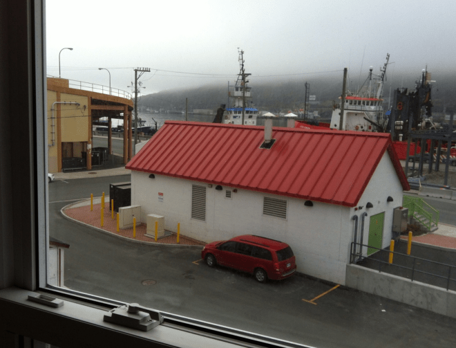
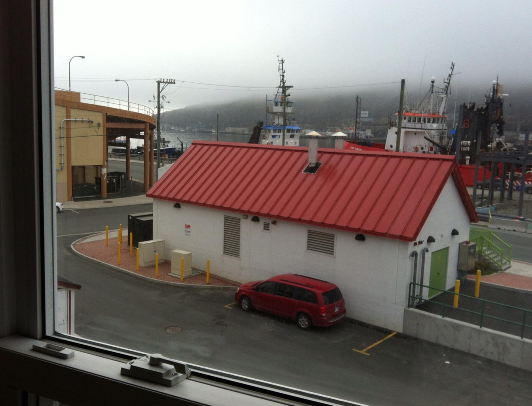
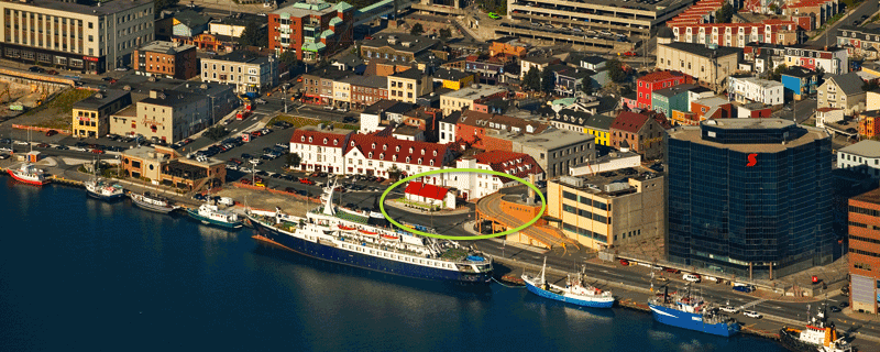
It’s a bit ironic that while on a business trip in Bangkok, a very exotic location for me, you publish a photo of a place that I consider very familiar, also through work. We’re overlooking the harbor of St John’s, Newfoundland, a beautiful place that is very fishing oriented, which is what draws a Massachusetts-based marine biologist like me to it. The harbor entrance is off to the left, and you can’t see Tower Hill, a very nice place to overlook the city and the Atlantic Ocean. St. John’s is way out into the Atlantic, and nearby Cape Spear is the furthest east one can go on the North American continent. The people are very, very friendly, and they like to drink and play music and sing, and they like you to come along, too.

I know I won’t win – this one is too easy, and I frankly detest the minute detail of winners who determine which hotel room, how high, la la la. That’s just silly. So I’m just happy to know after many years of reading your blog, I finally nailed one, as well as I care to.

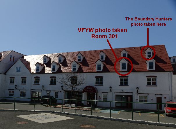
A cool view of the hotel:

image (3)

Details from another reader:

My spouse lived at the Murray Premises Hotel for a few weeks back in 2010, as part of the Opera on the Avalon Festival, and we visited her there for the last week. Her room was in an annex that faced Water Street, on the other side of this view, near where George Street connects – so if any readers know St. John’s they know that we had to wear earplugs to bed. George Street is perhaps the booziest party street on the planet – and that’s not hyperbole. To quote Wikipedia: “The street has the most bars and pubs per square foot of any street in North America, and is known to have bars that are open later than most others throughout Canada.” There was a 24-hr restaurant directly across the street where revellers would go to eat after the bars closed, then come out and barf into the street.

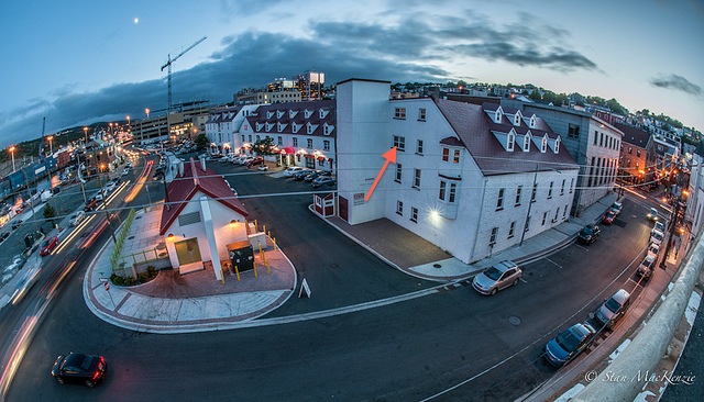
The photo is taken, I believe from the second floor of the Murray Premises Hotel, facing Harbour Drive. The parkade (as we call them here in Canada) is on the corner of Harbour and Beck’s Cove as part of the Bowring Downtown Centre (Bowring was originally a Newfoundland company est. 1811, a huge company with ships, provisioning, and trade on a worldwide scale in the late 19th and early 20th century – now is a gift store chain). If I’m not mistaken the photo is taken from just outside (or perhaps inside – I can’t quite remember the layout) of the breakfast room.

A local snaps a photo:

StJohnsHarbour

It happens, it really does happen! One sees the View from your Window Contest and says: I know that place!  Even better: That’s here!   I’ve seen other people have such reactions; I never dreamed that I’d be the same one day.

Another reader:

This is a view from the second floor of the Murray Premises Hotel overlooking St. John’s cove.  I recognize it because my mother did some demographic research on the 1918 flu there and I spent a few weeks with her in the summer.

Another:

Having Lived in Newfoundland for six years while going to school, I recognized this location immediately.  The big Irving oil sign on the opposite hill was a dead give away.  Still my favorite place on earth, would move back in a heartbeat if I could.

Another:

St John’s is a wonderful place with friendly people and appalling weather. After a business trip there years ago, while filling out my expenses back at home, three and a half time zones away, I noticed for the first time that the charming waitress who had served us in a downtown restaurant had left her phone number on the back of the receipt. Nothing like that had ever happened to me before or since. Regrets, I have a few …

Another:

image

I’ve been reading The Dish for yonks, but I’ve never actually sent am email on any topic.  I’ve certainly never been tempted to enter the VFYW contest.  I follow it avidly each week, but mostly to marvel at how people are able to pinpoint such exact locations from such scant clues.  Normally, the best I can do is narrow it down to continent.  But this week, I knew instantly and without a shadow of a doubt.  It was an instant recognition of home. I live on the mainland now, but I was born less than a mile away from where that photo was taken. That is St. John’s harbour.  That is Newfoundland’s characteristic rain, drizzle, and fog.  That is the Bowring building in the corner.  That is a view from the Murray Premises.

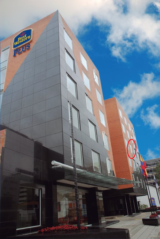
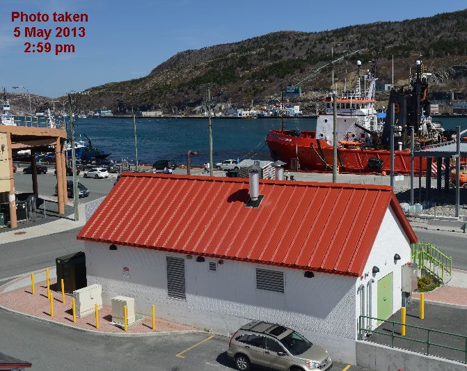
I don’t expect to win.  Having never entered before, I wouldn’t win any kind of tiebreaker, and if the location was obvious to me, it must be obvious to others.  But when I went to verify the location, I saw that Google street view doesn’t actually have data for the corner of Harbour Drive and Becks Cove.  So maybe it will be a tough one for Dishheads without local knowledge?  Probably not. But just in case, I’ve attached from the Murray Premises website that shows the scene from the opposite side of the harbour in much nicer weather. It seems like the picture has been taken from the third floor, and I’m guessing the most easterly window.

So very close. The following reader zeroes in on the correct third-floor room:

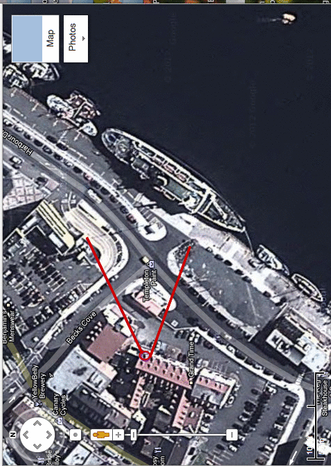
This is the Murray Premises Hotel, located on the town’s harbor in the block created by Harbour Drive, Beck’s Cove, Water Street, and Bishop’s Cove. If my estimation of the sight lines is edited original piccorrect, it’s taken from the bedroom of suite 301, or from this picture, the window furthest to the right and the lower one poking out from the roof. This picture shows the hotel with the the little red-roofed building (a paint shop, apparently) and the little overpass parking exit which are visible from the picture.

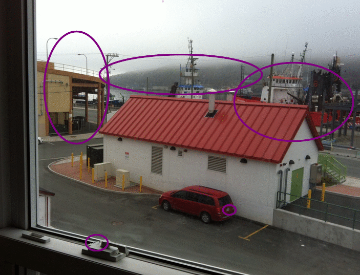
The first thing I noticed was that the car in the foreground seemed American-ish with an American-style license plate. I’ve never been to Canada, but I guess they use them there, too? I suspected that this placed the photo in British Columbia, Alaska, Washington, or Eastern Canada. I also saw the word “lock” on the window lock, so that confirmed some suspicion.

Next, I tried to identify the ships. The red one’s name is visible, but I couldn’t make out anything, really. I tried looking up ship prefixes, but none seemed to match what I was guessing. In doing this, though, I found Canadian Coast Guard ships that were painted in similar patterns. I have no google map w guidelinesreason to think this ship is a coast guard ship, but in looking through the CCG pictures, I found a link to St. John’s. This link provided another to a cool little ship-tracking site, so I looked through and didn’t find anything in St. John’s with a similarly-shaped name or a similar-looking boat. Silly me, I didn’t think about the fact that ships move, so I played on that site looking at other places in Eastern Canada.

At one point, though, I just thought, “No, St. John’s looked right.” So I went back and started looking at Panoramio pictures and street views, and of course, after about five minutes I saw the overpass. The area in front of the hotel seems to be under construction, and there was no street view. But right after the street view jumped past it, I turned it around and there was the overpass, street lights and all. From there, I just found the hotel name on the map, followed it to the website, looked at pictures to confirm, etc. And, you know, e-mailed the hotel to find out the room number. The woman who replied, Kim, was surprisingly nice given the oddity of my request.

An even more ambitious effort – and this week’s winner, given the reader’s long track record without yet clinching the prize:

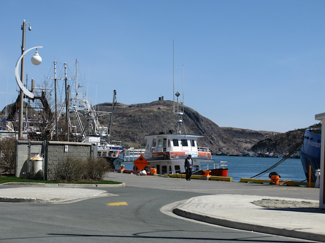
The key to solving this week’s VFYW contest (in under five minutes) was identifying the red vessel Murray Premisesin the background of the photo.  Turns out there aren’t too many red vessels with ALEX as part of their name.  The ALEX GORDON is an “anchor handling vessel”, built in 1975 and its most recent known port visit, according to this site, was St. John’s,  Newfoundland.  Some quick googling confirmed this was the sight of the photo and the hotel from which the photo was taken is the Murray Premises.

I figured quite a large number of people would also quickly identify the photo location so I thought about what kind of “added value” I could bring to my contest entry.  It suddenly occurred to me, and I’m probably letting the cat out of the bag for future VFYW contests revealing this, that I could utilize a hobbyof mine – geocaching – to help identify the room number and get pictures at the location.  I looked signs_681up the closest geocache to Murray Premises and emailed the owners of the geocache and asked them if they could help me out. And did they ever!  “The Boundary Hunters” went down to hotel and took several photos for me.  They identified the room from which the VFYW photo was taken as room 301.  Unfortunately that room was occupied but they did their best to recreate the photo and were able to access the window one up and one over. The ALEX GORDON is still docked at the same location and the weather has much improved from the time when the contest photo was taken.

Details from the submitter:

This one was taken this morning as the fog was lifting on St John’s Harbour. I took it from our room in the Murray Premises, a small hotel at 5 Beck’s Cove between Water Street and Harbour Drive in what was once a mercantile warehouse built in 1846 and where my husband and I are enjoying a romantic weekend getaway. It’s room 301 … is that specific enough?

(Archive)

The View From Your Window Contest

Screen Shot 2013-05-04 at 11.54.44 AM

You have until noon on Tuesday to guess it. City and/or state first, then country. Please put the location in the subject heading, along with any description within the email. If no one guesses the exact location, proximity counts.  Be sure to email entries to contest@andrewsullivan.com. Winner gets a free The View From Your Window book. Have at it.

The View From Your Window Contest: Winner #151

Screen Shot 2013-04-27 at 3.09.02 AM

A reader writes:

This appears to be the view of Pico from Faial, both central islands in the Azores. While not exactly tropical, the climate is warm enough to sustain the odd palm tree. I believe you can see the town of Horta smack in the middle of the snapshot.

Another:

Long-time follower, first time responding! I believe this picture was taken from somewhere on the eastern side of the Azorean island Faial. The mountain in the background looks to be Mount Pico, on the nearby island of Pico. I’m sure someone else will be much more exact, but my best guess is that it was taken somewhere on the outskirts of the city of Horta, possibly Conceição?

Since I can’t offer too much more detail, let me add a personal anecdote about Faial. My family is originally from mainland Portugal and my grandfather originally applied for a visa to come to the US in 1947, but didn’t get one until 1960. It took a series of volcanic eruptions in 1957/58 on the western side of Faial to finally open the door for my family and thousands of others to enter the US.  The eruptions led to Congress passing the Azorean Refugee Act of 1958 (co-sponsored by then Senator John F. Kennedy), which greatly  increased the amount of visas provided to Portuguese, both from the Azores and the mainland.

Another:

This looks like it might be Nevis in the distance, the island that is very close to St. Kitts. The country is St. Kitts Nevis, Nevis is so-called because Columbus thought that the peak was covered in snow, or nieves in Spanish, but it was just clouds.  There are no snow capped islands in the West Indies.  Nevis is just south of St. Kitts, which was named by Columbus for his patron saint.

Another:

It could be any tropical, volcanic region in the world, so most likely Central America or Southeast Asia. With that in mind, I’m guessing that this was taken from the port town of Balingoan on the north coast of Mindanao in the southern Philippines, looking across to Camiguin Island which is famous for its volcanoes.

Another:

krak small

Well, this week’s contest was too easy, as Anak Krakatoa Island is the subject of the photo. (Even were it not for the profile of the famous volcano, the red tile/metal roofs in the tropical paradise setting clearly suggest an Indonesia-like locale.)  The photographer has to be a tourist visiting Anak Krakatoa (Child of Krakatoa), with accommodation on one of the three islands that make up the remnants of the original Krakatoa island obliterated in 1883.

Another:

Well, we’re looking at a volcano in the tropics, sitting near a body of water.  Could be a lot of different places (it quite reminds me of my recent trip to Arenal volcano in Costa Rica), but searching Indonesia alone would take hours, I’m going to make an educated guess that we’re looking at Mayon Volcano in the Philippines, known for its majestic symmetry.  It sits on a body of water, the Albay Gulf, and there’s the little town of Manito right across the gulf from Mayon, so that’s what I’m guessing. (Watch, the volcano will probably turn out to be Concepcion in Nicaragua, or something in Indonesia and I’ll be off by thousands of miles.)

Another:

Costa Rica? Overlooking the Tenorio volcano, from Tilaran, or somewhere close? My husband and I went to Costa for our honeymoon in January and I’ve been dying to go back and this has the look, from the palms, architecture, terrain. Might be another volcano, but definitely Central America.

Another:

I spent the winter holiday cruising down the Pacific coast and stopped in both Guatemala and Nicaragua. Volcanoes in both places, but I’m guessing Guatemala.  Is that Lake Atitlan in the foreground? I don’t expect I’ll ever win the book – I’m just not computer savvy enough to do the calculations and draw the intersecting vector lines and give GPS data … but fuck it, let’s say this is taken from the top of the chicken coop on the farm of Pedro Zacapa on the outskirts of Santa Catarina Palopo, Guatemala.

Another:

Back in the 1980s, when I lived in Guatemala, Panajachel on Lake Atitlan was one of the places I’d go for a respite. At that time there were few tourists and even on Peace Corps wages I could stay in a decent hotel. I believed and still believe that it is one of the most beautiful places on earth. And the people were as beautiful as the land. Many of the villages on the lake were considered too dangerous to visit, but I would go anyway. Stupid youth. There was a Catholic mission in one village that was very welcoming. I had tremendous respect for the work of these people – nuns, priests, and others – doing such good work in a troubled place. I would visit the orphanage to get my hug quota fulfilled. The only negative was that many were from Minnesota and I had to withstand a barrage of Iowa jokes whenever I stopped by.

Another gets the right country:

I have never dared to respond to the VFYW contest before but the most recent one just screams Central America to me, and since I lived for a year and a half in Nicaragua, I’m going to go with that. The mix of vegetation, the layout of the house, the rusty corrugated tin roof, and the volcano on the lake is the spitting image of Mombotombo. The bricks in the foreground even look like the type made by all the towns along the Highway from Managua to Leon. I’m getting some serious nostalgia just typing this. So I’m going to take a guess based on the towns around Lake Managua and say this was taken outside either La Esperanza or Nagarote. Let’s just go with Nagarote. Thanks for the blast from the past!

Another nails the exact location:

Screen shot 2013-04-27 at 10.29.19 AM

A Google image search using the phrase “volcano island” quickly serves up a variety of candidates, including Volcan Concepcion, on the island Ometepe, in Nicaragua, with a cone-like shape similar to the mountain in the contest photo.  A subsequent search on “Ometepe” turned up photos so strikingly similar to the contest photo that they must have been taken from the same window. It didn’t take long to find the location by looking at Ometepe accommodations on Tripadvisor. The location is the Finca Magdalena guest house, near the town of Balgue, on the island of Ometepe, in Lake Nicaragua, Nicaragua.

Screen shot 2013-04-27 at 10.28.57 AM

Another:

On Google maps, my wife and I started moving north along the Venezuelan coastline in search of islands just off the mainland.  Eventually we reach Central America, and Nicaragua.  At this point one might notice a rather large lake set in Nicaragua named Lake Nicaragua, and set in the middle of that lake is … a volcanic island called Isla Ometepe.  In the lake.  Like a motherf*cking Bond villian lair.  It’s the coolest thing ever and I never knew it existed and it’s shit like this that keeps me doing this contest every week.

Another focuses on the hostel:

I am afraid this one will generate a lot of correct results, based on the fact that I found it rather quickly (20 minutes).  Clearly Caribbean landscape, but no island volcanoes seem to match the geography. I found some links to Costa Rica volcanoes and expanded my search to include Central America, which immediately produced several photos almost identical to this weeks view, all with the same outbuildings and varying degrees of cloud cover and snow on Volcán Concepción. Anyway, I believe the photo was taken from the upper floor of the Finca Magdalena Hostel on Isla de Ometepe in Lake Nicaragua. Judging by the angle and the window frame in the photo, I am pretty sure it was take through the small side window circled:

red-circle

Another:

I have never been there, but my Brooklyn-dwelling daughter traveled there last year, visiting a friend and climbing the other volcano, Maderas, which is dormant. She reported spectacular wildlife and loved hiking up through the rainforest; it is a nature preserve and a UNESCO Biosphere preserve.

Another:

This place is fantastic if you like troops of howler monkey. As a monkey enthusiast myself this locale was great for sneaking into the woods up the hill and grabbing a quick pic of the monkeys. We stayed monkeyhere one night on our way around the island back in 2010, since we’d heard they’d had this great fried mango food like Mango French Fries!  The whooping and screeches of the monkeys did not thrill most residents during the night, but boy was I wooed by their subtle songs. Just Beautiful! It had a great little restaurant style bed and breakfast feel, and there was a fantastically cute pet raccoon tied to tree. He did little tricks for food throughout the meals, although he didn’t seem too happy about the leash. Not sure how they got him – are raccoon’s common pets in “Nici”? I need get one of these!

But back to the monkeys! Howler monkeys can be heard from over three miles away. Amazing! We went all around the island listening for them. I felt like Jane Goodall or something finding these monkeys! HUZAAAAHHH!!! There they were! They mostly enjoyed the slopes of the volcano, which – woooweee – are a little steep for my legs. I practically fell right off of Conception. I’m not great at sketching but tried my hand at it – getting sooo much better at anatomical sketches. Probably should write my own book on this stuff.

Another:

When I saw this week’s VFYW, I nearly had a heart attack. Finally, a VFYW that I’d seen with my own eyes! This is the Finca Magdalena, a rustic farmhouse inn on an organic coffee farm, where I stayed with my husband and our three-year-old daughter, Isabel, several years ago. The Finca was our last destination on our trip to Nica. The ride in was rather complicated, hopping from ferry to bus to motorbike, but let me tell you, it was worth it. My husband and I loved the simplicity of the food, the staff, and most of all, the COFFEE! Nothing like some caffeine to get you up those steep Nica hikes! We ditched some clothes just to leave room in our suitcases to bring home as much coffee as possible.

The kind staff even introduced our Isabel to their “mapachito”, the cutest little raccoon they keep tied to a nearby tree. He was friendly as ever. Needless to say, this was the highlight of Isabel’s trip, and she played with him constantly. Talk about a free babysitter ;)

Another:

Arriving to volcano island

During a winter break in law school, I traveled to Nicaragua with one of my best friends.  As I’m sure most tourists would be, we were intrigued by the existence of a volcano in the middle of a lake.  We set aside a couple of days of our whirlwind tour of the country to travel to Isla de Ometepe.  On our only full day on the island, we spent an exhausting eight hours scaling the muddy slopes of Volcan Concepcion.  We brought our cameras for what we believed would be the incredible views on top.  Unfortunately, we had not thought through the implications of the term “cloud forest.”  As the moniker would suggest, the top of Concepcion is entirely banked in by clouds and thick mist at almost all times (as the entry photo depicts).  Despite having no views, the slopes were still a wonderfully dense jungle of packed vegetation, tangled tree limbs, and howling monkeys.

Another:

I knew this one immediately, not because I’d been there but because growing up we constantly had Ometepe coffee around the house.  The distinctive shape of the volcano was printed on the coffee bags.

About a third of the roughly 150 entries correctly identified Ometepe, and seven of those were from readers who have identified difficult views in the past without winning (“difficult” being defined as a view in which only 10 or fewer readers correctly answer it).  To break that tie, the reader among the seven who has participated in the most contests (11) is the winner this week:

This week’s view is from the top (mansard) floor of the Finca Magdalena Hostel. It is located on Ometepe Island, which rises out of Lake Nicaragua. Two volcanoes dominate the island: Concepcion, seen in the original view, is the taller, more symmetric one; and Maderas is the flatter one on the right at the link above. The hostel is on its northern slope. I knew this had to be in the Americas, since there is a cactus in the foreground, on the roof (all cacti but one are native to the Americas). I tried ‘volcano island Central America’ as a search phrase and Ometepe was the top result. I found this almost identical image on Panoramio and then the building it was taken from. (The window in question is the small one on the right.)

One more view:

VFYW Ometepe Interior Actual Window - Copy

(Archive)

The View From Your Window Contest

Screen Shot 2013-04-27 at 3.09.02 AM

You have until noon on Tuesday to guess it. City and/or state first, then country. Please put the location in the subject heading, along with any description within the email. If no one guesses the exact location, proximity counts.  Be sure to email entries to contest@andrewsullivan.com. Winner gets a free The View From Your Window book. Have at it.