The View From Your Window Contest: Winner #145

Screen Shot 2013-03-16 at 3.59.30 AM

A reader takes a stab:

Some Eastern European city, height-restricted buildings, possible government tower (exempt from the restiction) on the horizon, with a tower crane, other cranes nearby. Possible train station roof below. Possible pre-Communist city reconstruction building from which the picture was taken. Aside from the gargoyle-faced building, nothing in the picture looks to have been built prior to about 1960, which again makes me wonder if this isn’t in some city that was either re-built after Dubya Dubya Two, or was the work of one of those Great Leap Forward-type master plan. The sky is grey, the buildings are grey, the people IN the buildings moods are grey …

Another:

This picture was taken just before the photographer flung himself over the edge. He was overcome by the sheer drabness of the view, and thought that his dead body would add, at least, a little touch of the unexpected to an otherwise banal, horrid place. His family, while quite distraught, quickly realized that this view could be in almost any city and vowed to remain exurban.

Another has a more specific guess:

The view from your window is located in Washington, DC.  The picture is looking westward and is overlooking Union Station. In the background is First St.  One of the buildings is the Federal Energy Regulatory Commission I think.

Another:

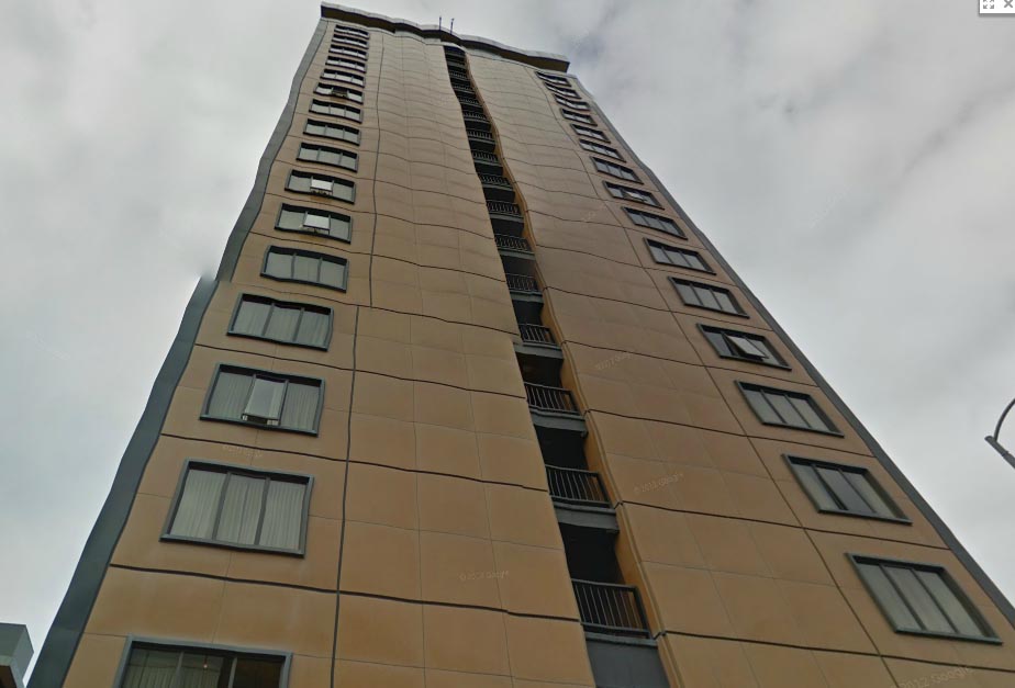
OK, the second I looked at this picture, I thought “Austin” because the building in the center of it looks an awful lot like the UT Tower and I think I see the Castilian dorms nearby. A photo of Austin seems like a logical picture for you to post this week, given that SXSW is wrapping up this weekend.

Another:

It’s a very tough photo, and I don’t see any landmarks of Buenos Aires, but some of the buildings could definitely be from there and the mix of old buildings with newer ones it’s pretty typical. In addition, the blue small structure you see on the right could be one of the newspapers’ kiosks you see everywhere in the city. And finally, since the new Pope is from there, that’s what I’m going with for this week.

Another:

The construction project in the deep background is probably the best clue. I searched online for skyscrapers under construction. After I delved a little deeper in to the promising ones, I’m guessing it’s the Shanghai Tower. The incongruous architecture in the foreground also suggests Shanghai, as the city is host to a surprising number of historic buildings. I would try to be more precise, but Shanghai’s images on Google Earth are full of smog. I think this contest is giving me an asthma attack.

Another:

Normally I don’t actively participate in the contest, but instead just read the award entry on Tuesday afternoon. This week, though, I had a really strong hunch that this was my hometown of Bangkok, Thailand. I did most of my growing up there before moving to the US for college. Now that I’m in medical school, I don’t get to go home as often, so it might just be a figment of my imagination that the building off in the distance is Baiyoke Tower 2, which I believe is the tallest building in the country.

The picture was taken from somewhere near one of the BTS train stops. I couldn’t figure out which one in particular, though, so I called up Mom and Dad who still live in Bangkok, and asked them to drive around the city trying to figure it out. They declined to do so.

Another:

I came up with this guess in less than five minutes.  Whether or not I’m right, at least I had a plausible chain of reasoning.  The glimpse of parapet in the foreground reminded me of Gothic towers in Western Europe.  But buildings in the background are all modern.  So I started thinking about places in Europe where the old city was destroyed in WWII and was subsequently replaced with new construction.  That brought me to Dresden, Germany.  With a quick check of Google images, I found a picture of Dresden Station – which has long, arched roofs that seem to match those in the middle of the contest picture:

FP*146507

Another gets on the right, er, track:

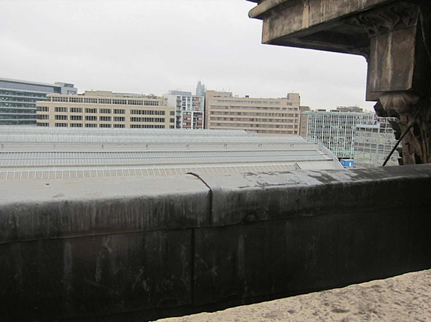
We appear to be looking out over the kind of railway station roofing that’s very common throughout the railway approaches and termini of central London: Liverpool Street, Waterloo et al. And the grime on what appears to be ornate 18th or 19th century stonework in the right foreground is very familiar to anyone who’s lived in London. And is that the Nat West building in the distance? I fully expect to be wrong by well over 10,000 miles.

More like feet. Another gets even closer:

The roof in this week’s picture strongly suggests a current or converted railway station. The Musee d’Orsay in Paris was my first thought. It doesn’t appear to be it, nor any of the other Paris train stations. Given the size of the station (if it actually is one), the old stone of the building from which the photo was shot, and the density of the build-up around, the location is probably in the center of a major European city, one of the classical stations from the heyday of trains. I didn’t find an exact match searching between Rome and Glasgow, but will guess St Pancras Station in London.

Correct city. Another zeroes in:

Scottish ex-pat in Silicon Valley and first-time VFYW entry! This one just screamed “London railway terminus” at me. Why? The foreground old roof with lead flashing reminds me of so many British rooftops. The juxtaposition with the modern buildings in the background and the arched roof (almost certainly over a railway station) just screamed London at me. First thought was St. Pancras, but a quick Google proved me wrong. Victoria? Bingo!

The photo is taken from the Grosvenor Hotel, overlooking the roof of Victoria Station, looking towards the buildings on Bridge Pl. From the height of the buildings, I would say something like the 5th floor counting with the British convention starting with the Ground Floor. I’ve circled my guess at the location on the enclosed pdf.

Grosvenor Hotel it is. A visual entry:

VictoriaStation-da09724

Another reader:

This will be easy for any London commuter so I assume you’ll get loads of responses. That’s the double arched glass canopy roof over the platforms at Victoria station, taken from up on the roof of the station building looking south-east towards Vauxhall.  I’m sure you’ll get loads of bods from the Torygraph giving you the exact location of where the photo was taken – their headquarters are in the office block above the station concourse.

You can see the Vauxhall tower in the distance with the crane on top – that’s the crane that was recently hit by a helicopter in heavy fog, with crane and helicopter coming down in the carpark of our Sainsbury’s on South Lambeth Road.  Our houseboat is moored on the Thames between that tower and Battersea Power Station. Best wishes from the UK, and keep up the great work.

Another visual entry:

angle-london

Another reader:

Amongst its various amenities, the Grosvenor Hotel offers the “Cora Pearl Experience” – an homage to the “infamous 19th Century Parisian Courtesan.”  Born to a humble background working as a street prostitute, Pearl eventually found wealth and notoriety as the companion to the rich and powerful of Europe – including Prince Napoleon and Prince Willem of Orange.  There’s also a cocktail named after her, the “Tears of Cora Pearl” – the only recipe I can find says that it is comprised of vodka, creme de cacao blanc, Domain de Canton, fresh strawberries and topped with champagne and 23 carat gold leaf.  I was going to say that I might celebrate with one, but like Cora Pearl herself, is probably a bit too rich for my blood.

Another visual entry:

circle-red

Another reader:

As a railways enthusiast and employee of Deutsche Bahn (German Rail), I was determined to solve this week’s VFYW upon seeing the unmistakable roof of a large train shed. Not immediately recognizing the surrounding buildings, I was able to quickly rule out Germany (I’m quite familiar with all of our train stations and their surroundings). Something about the modern architecture and the density said “London” to me, and being familiar with most of the city’s train stations I started my search there. St. Pancras was clearly out – its single-span train shed could not be mistaken for the two spans seen here. Neighboring King’s Cross was a possibility – it sports a two-span shed but a quick look at the adjacent buildings allowed me to rule it out as well. My next guess was Victoria, and lo and behold, the buildings matched!Screen shot 2013-03-16 at 6.46.48 PM

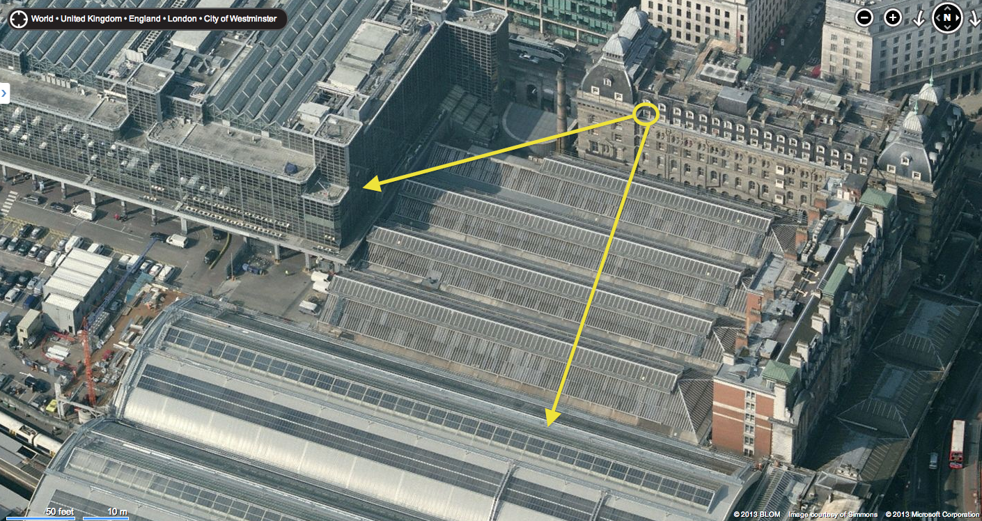
Then it was just a matter of finding the precise location of the photographer, who must have been standing on a roof of a neo-classical building on the side of the trainsheds opposite the buildings seen here. That pointed me to the Thistle Grosvenor Hotel. Counting the ribbing on the roof of the train shed helped me line up the photographer’s location along the parapet of the hotel. I’ve marked my estimation of the location in two of the attached photos, with the third showing the buildings seen in the background of the VFYW shot.

For what it’s worth, I’ve previously identified Boston, MA (September 2010), Warsaw (March 2012), Depoe Bay, OR (May 2012), and Bethany Beach, DE (July 2012), but have yet to win a contest. I also think that working for Europe’s largest railway company should earn me an extra point, should you need a tie-breaker!

The tie-breaker this week goes to the reader who guessed the room closest to the actual one:

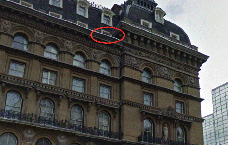
This is my third hit in four weeks … either I’m getting the hang of this, or they’re getting easier! The grey architecture and even greyer weather suggested Britain to me, and as a British expat I’d feel fairly ashamed if a missed a British VFYW. The building in the foreground is clearly a train station, and so a few searches got me to the Grosvenor Hotel, near Victoria station in London. Based on photos on the web of the Grosvenor, I’m saying the room is one floor from the roof, which by my calculation will put the room in the 500 range. Room 601, according to a photo on tripadvisor, is at the northern end of the building, and from the same source room 421 is on the western side, so I’m guessing around room 514.

Details from the submitter:

This is taken from Room 508 of The Grosvenor Hotel, adjacent to Victoria Station, London. The wonderful thing about these back rooms is that the station roof muffles the sounds, such that the public address announcements sound like the adult voices in “Peanuts” cartoons – “wah wah weh wah weh…”

The best visual entry this week:

Grosvenor Hotel VFYW.002

One more reader:

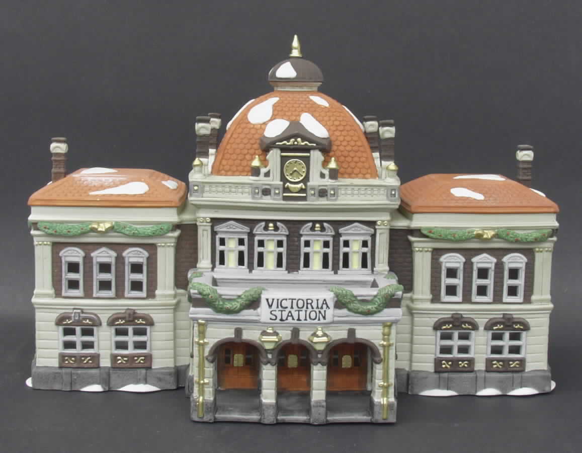
I’ve always been curious to see if the Dish team could find good contest views from otherwise well known cities like London and I think this one hits the spot. On a personal level, I love that it was taken at Victoria Station. As a kid my family had a set of decorative porcelain houses called Dickens Village which we would display at Christmas, and one of them was a miniature Victoria Station. That little station helped form my childhood image of London, and although in real life it proved far less adorable, it’s still the first train station that pops into my head when I think of the city.

Attached is an Ebay image of that miniature, marked bird’s eye views and an aerial shot of the hotel and station from way back in 1945:

Victoria Station Miniature - Copy

(Archive)

The View From Your Window Contest

Screen Shot 2013-03-16 at 3.59.30 AM

You have until noon on Tuesday to guess it. City and/or state first, then country. Please put the location in the subject heading, along with any description within the email. If no one guesses the exact location, proximity counts.  Be sure to email entries to contest@andrewsullivan.com (the old address still works as well). Winner gets a free The View From Your Window book. Have at it.

The View From Your Window Contest: Winner #144

Screen Shot 2013-03-08 at 8.13.47 PM

A reader writes:

I see we’re going back to harder contests after the hundreds of winners in the previous weeks. The street light, no standing sign, and fire lane tell me that this view is definitely somewhere in the US. The haze in the distance kind of reminds me of the exurban areas of Los Angeles. So I’ll guess Riverside, California, and leave it at that. I don’t think 10 hours of internet searching would get me any closer. Perhaps this is one of those construction projects that stopped mid-recession and never got started again?

Another:

Has to be Las Vegas! All the tells are there: the American “no parking” sign and lamppost; flat barren landscape, the big city buildings in the distance.  This must be some of the construction that surrounds Las Vegas, started in the boom times and stopped suddenly when everything crashed.  As you fly into Las Vegas you can see how the outskirts of the city were once being developed, housing subdivisions that have streets and sidewalks, but no houses (or even worse, one or two houses in an otherwise empty development).  I’d give 10:1 odds that I’m correct!

Another:

Tough one. I was going to guess Fargo, North Dakota, because the land is dead-flat and there’s so much new construction going on there, but there’s no snow. That skyline in the background looks a little like Tulsa, and that’s what I’m going with.

Another:

Just a wild guess mostly, but it is obviously a picture next to a decent, but not overly large, city.  The skyscrapers are tall enough to give a good view from ~5-10 miles away.  The signs are English, and the climate seems to be similar to that of Texas, warm and relatively dry.  Since it doesn’t seem the downtown is either dense, or large, enough for Houston or Dallas that leaves San Antonio.  Now to see the e-mail from someone who picks the exact window.

Another:

SXSW started this week, and as I have no clue where in the world this is, why not guess Austin, Texas?

Another:

This picture feels like the Meadowlands area.  The long expanse of undeveloped. swampy-looking land leading up to a series of nondescript urban buildings.  A Google image search suggested this hunch might be correct (e.g. see attached – source here).  Other clues: the “fire lane” marking puts us in an English-speaking country, and that no parking sign looks like the ones in the NYT metro area.  the town that the Meadowlands are in is called East Rutherford, and a Google Maps search of it shows certain sections that appear isolated and with long windy roads.

Another:

I would rate this one as nearly impossible. A flat area in the US.  It’s a new office park, or something similar, so perhaps a growing area. A few medium sized buildings in the background. I’ll take a wild stab and guess Lincoln, Nebraska, somewhere near I-80 and Hwy 77.

A reader nails the right city:

I immediately thought “Sacramento, CA” when I saw this photo. Unlike most of America at this time of year, California’s Central Valley is green. My wife and I lived in Sacramento for two years, and we would visit Davis, CA as often as we could (they have a great Farmer’s Market). From the east side of Davis, you can often see Sacramento in the distance; so I’m going with Davis, CA, near El Macero Estates.

Another:

For the first time ever, I think I recognize the location. It looks like it was taken in Elk Grove, California, a suburb south of Sacramento. That looks remarkably like the half-finished, abandoned mall at the south end of the city limits. But I don’t recall there being any buildings near that lovely wasteland that are actually occupied as residences or businesses. Still, it does look like Sacramento’s petite skyline in the background. Unfortunately, there are probably several places around here that would allow a view such as this, and around the country as well. At least I finally have a guess based on more than intuition.

Another:

Around Sacramento stalled developments were a common site. Though many of the housing projects have started up again, check out this similar pre-ruin south east of Natomas in Elk Grove:

Screen shot 2013-03-09 at 10.18.24 AM

Neither project has moved an inch since the financial crisis.

Another gets the right part of Sacramento:

This area is called Natomas and the hotels serve the Sacramento International airport near by. Two doors down is a hot dog place with late night drive through. For years these building skeletons have waited for real estate to turn around. The blocks are sketched out and the cement sides raised but there hasn’t been the money to finish them. I’ve stopped there at dusk before to look at them. To the north are the rice fields of the Sacramento valley. Natomas grew from the fields in a few decades and the effect, along with the half constructed buildings has always brought Caffa to mind- the outpost remade by Venice and then the first to collapse under the plague.

Another adds, “The empty development is locally known as “Stonehenge,” or sometimes, “Natomas Stonehenge.” Another:

First-time participant here, I never thought I would be able to correctly guess a VFYW contest. The picture was taken at the Homewood Suites in Sacramento, CA. I will try to be as specific as possible since I am sure anybody who stayed there might remember the location: the second floor, on the southeast side of the hotel indicated by the arrow in the attached picture:

SMF

I stayed there a couple of years ago on a business trip and I remember jogging around the area.

So very close – it’s actually the third floor. About a half-dozen readers correctly guessed that floor, but none of them have guessed a difficult window view in the past (“difficult” defined by only ten or less correct answers), so breaking the tie is tough again this week. But the following entry was the most detailed and proactive of all:

Since I live in an eastern suburb of Sacramento, my first reaction was, “Wow, there are dozens of these abandoned developments all over the Sac region; there’s even an entire mall.” Then I noticed that the city skyline looked familiar, the tree was budding, grass/weeds growing; plus the No Parking sign eliminated a large chunk of the world. So Sacramento in early March seemed like a possibility.

A quick scan of Google Earth and a comparison to various skyline images confirmed that the image must have been shot from the north toward downtown (sunset shadows and open space were clues). After a few more minutes map-scanning, I was confident I had it thanks to the sidewalk design, driveway arrows and landscaping. So it’s Homewood Suites (a hotel) at 3001 Advantage Way in Sacramento, CA. And my hunch was that it was taken from a window on the 3rd floor:

VtoYW Sacramento

You might find it interesting that the commercial structures mask a view of one of our many housing failures in the region. An entire neighborhood of streets, utilities, house foundations overgrown by weeds, and most striking – a small community center and swimming pool that’s abandoned and deteriorating. Looks like the developer sold five townhomes before shutting down; they appear occupied, so I hope the owners aren’t paying HOA fees for that pool.

By the way, my 3- and 6-year-old daughters and I (ok, mostly me) decided to make an adventure of it and attempt to see “The View TO Your Window.” We didn’t expect to replicate the view FROM, but fortunately, this is a window in an open-space hallway on the 3rd floor, just outside of room 301 (and the hotel staff were very friendly):

VFYW Sacramento recreated

My 6 year old, comparing the original image on my phone to the actual view, thought it was amazing that “we found the match.” Then she immediately asked, “What will we do if the next picture is in China? Will we go there?”

Thanks for spawning a fun excursion for the three of us. (Mom thought we were crazy.)

Congrats, we’ll get a book prize to you soon. One of the contest’s most consistent winners adds:

The site is probably familiar to local basketball fans, as Arco Arena, home court of the Sacramento Kings, is visible rising behind the unfinished buildings on the left. Because the Kings will likely be sold this year, the city is actively working on development plans for the surrounding area. As for the unfinished buildings, they were originally supposed to house a TGI Friday’s, a Sonic Drive In and healthcare buildings, but the recession drove the developer into bankruptcy.

VFYW Sacramento Recession Marked - Copy(1)

Could there be a better monument to the last decade than the half completed shells of suburban chain restaurants and medical offices? The street in front of your viewer’s hotel is named Advantage Way, but it’s really the high-water mark of an entire era.

The photo submitter’s entry, for the record:

Sacramento, California, 5pm on 2/13. Looking from 3rd floor of the Homewood Suites in Natomas. Someone had great plans for a development in this area – foundations are laid, streets have names, but it apparently came to a crashing halt. I’ve been coming here on business for 7 months and it’s been like this since then. You can see the slightest sliver of the (hilariously named) Sleep Train Arena, home of the threatening-to-move-to-Seattle Sacramento Kings.

Update from the submitter:

The guy who won was exactly on target: I took that photo from the hallway window near room 301 of the Homewood Suites. I’m delighted to hear that he went there with his daughters. I’ll be back in that hotel on Monday and will let the staff (who know me by now) know how this all came about. Extra fun – thanks!

(Archive)

The View From Your Window Contest

Screen Shot 2013-03-08 at 8.13.47 PM

You have until noon on Tuesday to guess it. City and/or state first, then country. Please put the location in the subject heading, along with any description within the email. If no one guesses the exact location, proximity counts.  Be sure to email entries to contest@andrewsullivan.com (the old address still works as well). Winner gets a free The View From Your Window book. Have at it.

The View From Your Window Contest: Winner #143

vfyw-contest_3-2

A reader writes:

Perhaps its something like familiarity bias, but I’m always struck by how many images look like my own locale, Southern California.  This view with the large grey mountain in the background, the cars in the foreground, the palm trees in the mid-view, could be a suburb of Los Angeles.  But there is a pagoda-like roof to the left, and a Islamic looking tower in the mid-ground, and I’m going to go with Tehran, Iran.

Another:

I’ve never put in a guess on one of these before, but I just passed through Puebla, Mexico the other day and it has a volcano similar (indeed, identical, hopefully) to the one in the picture.

Another:

Olympia, Washington? I couldn’t find the exact house, but isn’t that Mt St Helens?  With no snow?

Another:

If not Naples itself it is one of the surrounding cities. The mountain in the background is Vesuvius, unless of course I am wrong. I spent a day at Pompei and saw it from many views. It wasn’t until later in the day that I realized the peak I’d been centering in my photos was only the far right side of what was left of the mountain. It was with that realization that the full magnitude of the event hit home as you could see there was a huge piece of the mountain that is missing.

Another is on the right track:

This has to be Japan.  There’s the characteristically roofed building in the lower left hand corner, the boring modern sameness of all of the building you see in the skyline, the cars all small, sleek and new.  I looked at a topographic map of Japan to see which cities would be surrounded by nearby visible mountains.  After guessing around a bit I found a photo of Fukuoka which seemed to match the flatter topped mountain in the background.

Another:

It’s 1:05 a.m. after a birthday party in Montreal, and I should know better than to take a crack at a VFYW contest on a hunch, but here goes. The clay tiled roofs and right-hand drive cars suggest Japan. The palm trees and exposed staircases suggest a southern climate. The urban density says a large city on a southern Japanese island, and that suggests Naha, Okinawa. And now I’m going for some poutine (cheese-curds, gravy and French-fries – renowned Canadian hangover cure!)

Another:

Here’s why I love this stupid, awful contest.

Since Saturday I’ve learned that the ugly institutional Soviet-style architecture I’ve hated my whole life is called Brutalism, I’ve learned that the Scion line is only sold in North America, that Grupo Bimbo has opened two two bakery facilities on the outskirts of China, and I’ve dusted off some pretty dormant geographic knowledge I once knew by heart and clearly took for granted.  I feel smarter for having searched.

Here’s why I hate this fun, stimulating contest.  None of the above mattered much in my search, and I’m still left without even being 100% certain of the right continent.  My answer may as well be Pangea.

This view is insanely frustrating.  It is a terribly ugly city.  There are no people in the view.  The city is almost entirely bereft of notable signage or advertising.  There are cars, but they are all backed into a deck.  The roof tiles suggest Asia, as do the few visible characters, but I eventually went crazy and at moments thought those were red herrings too.  I have image searched things as varied as Nigeria, East Timor, the suburbs of Beijing, and seemingly every stray corner of Oceania.  My wife was convinced one of those horrible buildings was a hospital based on the size of the rooftop access doors, and was Googling things like “asia hospital helipad”.

I’m saying Akita, Japan, or someplace near.  I have my reasons but they’re all terrible, and this guess is also I’m convinced.  I’m only sending this in because after my wife and I spent most of two evenings on it, I feel I owe it to myself to enter a guess, any guess.  I have a list of about 12 questions I need to have resolved about this view, and I’ve probably never anticipated an answer this much.

And somebody was there last week or was best man in a wedding on top of that stupid TV network building looking thing with hardly any windows.  Or some other bullshit.  I hate that person.

Another:

Fuji-san!! That was my first thought when I first saw the picture.  I have seen it from a speeding Shinkansen several times. I knew it was Japan – the cars in the parking spaces looked right – and the vague lettering on the signs too.  But the longer I looked the less and less it looked like Mt. Fuji, which is more conical and would certainly have snow on the summit this time of year.

I looked at other mountains … Mount Haruna?  No, too flat. Maybe Mount Ontake in Nagano?  I looked at a lot of mountains. Then I looked some more, and wondered if maybe it wasn’t Mount Fuji after all.  I can find some images that look a little like that.  So … I’m sticking with a view of Mt. Fuji, from the city of Fujinomiya.

Another sends a view of the right mountain:

Kagoshima City VFYW Volcano Bird's Eye3 Marked - Copy

Another identifies the right city:

This is the first time I have ever attempted a VFYW. To be honest I never really understood the appeal of internet searching as a form of fun. I always just want to find something, the searching part is actually kind of annoying. However, there were many clues in this view that led me to believe I could be victorious. The lettering on the buildings, the foliage and the FREAKING VOLCANO!

Because of the clues I’m sure someone has already beat me to the location as Kagoshima, Japan. The characters on the sides of the building are nice and friendly, indicating Japanese  The right side steering is another giveaway, that and the cars are all new and spotless. I first thought Okinawa Prefecture. Some of these islands are volcanic, but none of the mountains I could find were near city big enough to have multiple tall buildings. I was searching for photos of Okinawa and I stumbled on a blog in English about someone who lives on Okinawa and bam! There is that volcano! The particular post was about a trip to Kagoshima and from there it was easy to locate. The weird green roofed?(color blind) building in the foreground is pretty unique and is the Kagoshima City Museum. There is only one tall building behind it that is either a hotel or apartment building, I’m not sure. When I click on the building in Google maps its says “Kagoshima-ken, Kagoshima-shi, Shiroyamachō.” Whatever that means.

It was a thrill to find it, thanks bunches!

Another:

I think this is my fastest ever, less than ten minutes from seeing the contest photo to finding the building from which the photo was taken. I don’t have a story or anything to go along with the guess, but the photo was taken in Kagoshima, Kagoshima Prefecture, Japan, facing east towards Mt. Sakurajima:

sakurajimia

Another:

I had a feeling that if I could figure out what the stylized kanji on the left said that it would lead me to the window and I was right! My other Japanese friend and I were able to correctly piece together than the kanji are

満秀

which leads immediately to the hotel Manshu in Kagoshima, Japan!

Another:

Kagoshima is the hometown of Heihachiro Togo, the great Japanese admiral who humiliated the Russian navy at Tsushima. Sakurajima sits due east of the city across a narrow stretch of Kagoshima Bay. Since the view is to the east, we are looking for a part of the city with streets running southwest-to-northeast. A quick aerial tour shows that the oldest part of the city – bombarded by the British in 1863 – fits the bill. The copper-roofed building is the Kagoshima City Museum of Art, and the green-surfaced parking deck in the VFYW’s foreground is plainly visible as part of a large apartment complex to the west. Its address is Shiroyamacho 3-35; Google translates the name of the building as “Surpass Shiroyama Park City.” I’ll say it’s a view from the top floor, about a quarter of the way along the northeast side of the third building up the hill.

Another sends an image of the building:

kagoshima

This one was really easy so I’m sure there will be a lot of correct responses given the amount of signage in Japanese.  The photo looks like it was taken from the Surpass City Shiroyama Park apartment building in the Shiroyama-cho district of Kagoshima Japan.  Probably from the 5th or 6th floor of the main building or one of the units right above the parking lot. I’ve attached a fun rendering of the building which overlooks the active volcano on Sakurajima.

Another adds:

These are “manshon” or condominiums, one of which seems to be for sale right now for about $226,000. Looks like a lovely spot, and the statue of Saigo Takamori (The “last” Samurai) right across the street adds interest. Somehow I wouldn’t want to test my luck that close to an active volcano, though.

Another sends a painting of the volcano:

05123742

Sakurajima in Morning Light, Kagoshima, Kyushu by Toshiro Maeda

Close to 250 readers correctly answered Kagoshima, and a dozen of those have correctly guessed difficult views in the past without yet winning, so determining a winner this week is extremely difficult, especially without knowing the exact floor or unit from which the photo was taken. One Kagoshima guesser goes for bribery:

If I win I will subscribe!

No pay-for-play on the Dish. So to break the tough tie this week, we found the reader among the aforementioned dozen who has entered the most contests overall. The image from that reader’s Kagoshima entry:

Kagoshima

Congrats to that reader on the close win. From the photo’s submitter:

My daughter took this picture on February 3 at 2:30 PM. The view is the city of Kagoshima, Japan, looking across the bay to the active volcano Sakurajima, which is only about five miles away. The exact address is 701 Surpass City Shiroyamakouen, 3-35 Shiroyama-cho, Kagoshima. I have no idea what all that means, unfortunately,although the neighborhood is called Shiroyama-cho. People should notice the nearby mountain that is recognizable as a volcano, and the roof in the foreground looks very Asian so I think people may get to Japan quickly, but Kagoshima, onthe southern island of Kyushu, is pretty off the beaten track.

viewer (1)
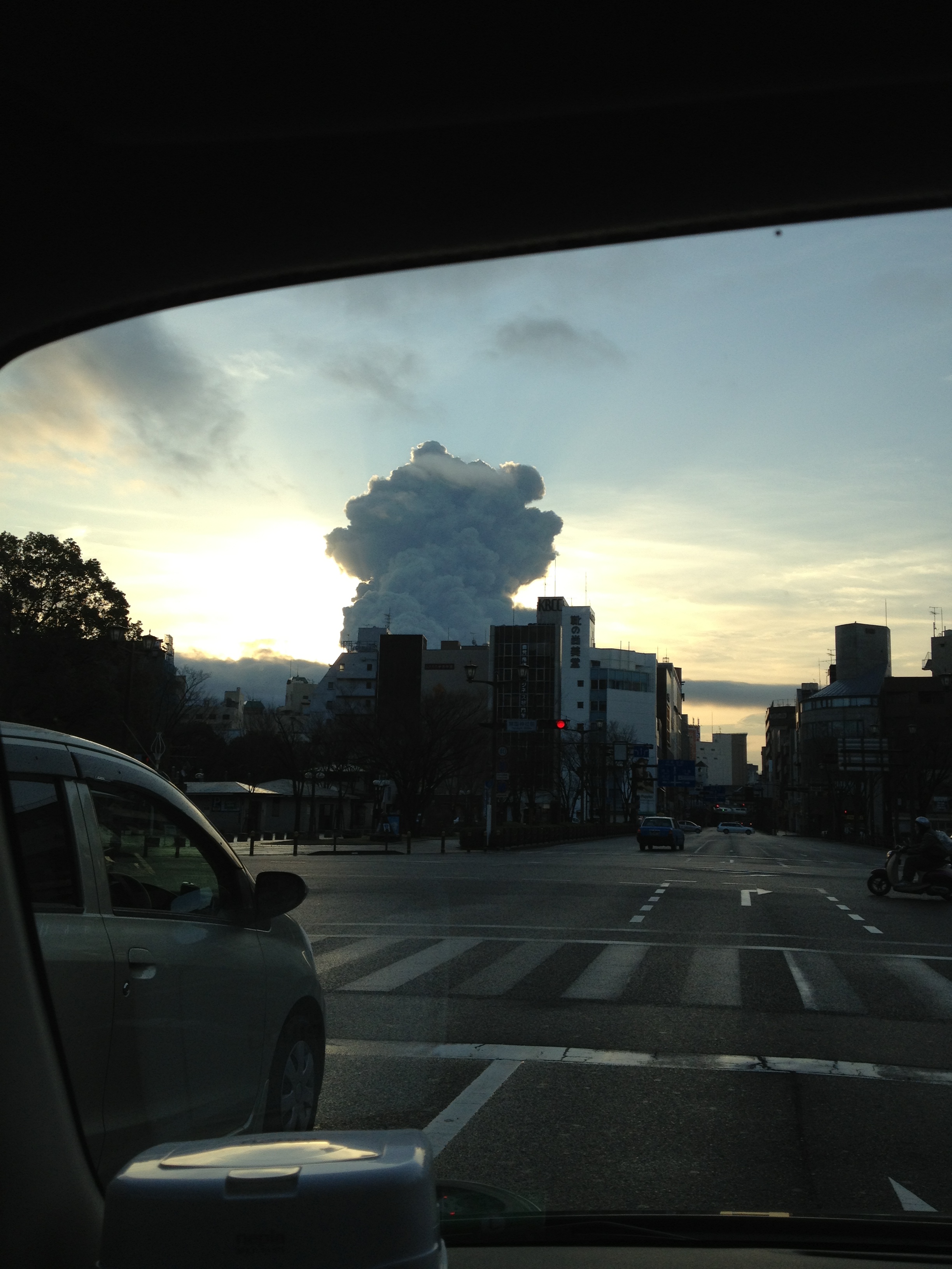
She is studying in Tokyo for her junior year abroad, and is doing an internship for a month between semesters as a distillery in Kagoshima. She likes to look at the VFYW and is always sending me photos asking if this would be a good one, and I finally think she got it right.

Love the contest and the Dish! Of course I’m a subscriber. Also sent you your contest view of Waterton Lake last summer, which thrilled me to see on the blog. Keep it going everyone!

He follows up:

Awesome to see my daughter’s picture of Mt Sakurajima from Kagoshima as this weeks puzzle entry! I thought I’d pass along a new picture she sent me (a view from your car window) of the mountain in a big ashy eruption the other day, taken from the streets of Kagoshima:

BIIIIIIG ASH CLOUD

(Archive)

The View From Your Window Contest

vfyw-contest_3-2

You have until noon on Tuesday to guess it. City and/or state first, then country. Please put the location in the subject heading, along with any description within the email. If no one guesses the exact location, proximity counts.  Be sure to email entries to contest@andrewsullivan.com (the old address still works as well). Winner gets a free The View From Your Window book. Have at it.

The View From Your Window Contest: Winner #142

vfyw-ds

A reader writes:

Snow. US. Flat. Midwest-looking. How about Kansas City, MO, post blizzard?  I realize this isn’t precise enough to win in all likelihood, but why not try.

Another writes:

Well this is my first entry in the window contest and pretty sure I am off on the city and most likely the state, but I am sure it is in the northern portion of the United States, as there is snow and pine trees.  Looks like the West, as there seems to be a decent amount of sprawl.  Possibly next to an airport, as there looks to be a Hilton or Marriot in the distance and a Rodeway Inn on the right. So I am going to go with Boise, Idaho.  Hope someone gets this one; it wasn’t easy with a night-time picture.

Another:

This is one of too many grassy knoll cities in the Rust Belt. Grassy knolls replacing older buildings of character knocked down in a thoughtless enthusiasm for the new that never arrived to fill the spaces left behind. So a piece of architectural dreck fills the center of this photo with plenty of parking to spare. Probably isn’t South Bend, but I’ve been there and with the snow and USA cars this week’s VFYW shines as sister city to that strange place, now existing on the crumbs thrown by its neighbor, Notre Dame University.

Another:

Issy-les-Moulineaux, France? I was there for a conference years ago and it was the first place that popped into my head when I saw the photo. Post-industrial suburban Paris. Can’t wait to learn where it really is!

Another:

Your profile caught my mind and heart and i cherish you so much. Please contact me so we can know each other better and i can send you my pictures for you to see more of me. I have something about me i will like to share with you. Distance, religion, skin color or other geographical difference has nothing to do with a sincere heart that seek for love and care. I will be wait you email, till then remain bless and take good care of yourself as i will always think about you because you caught my fantasy and passion.

Nice try, spam bot. Another:

Oh, goodie. It’s dark outside. There goes narrowing it down by landscape. But just because it’s nighttime doesn’t mean it’s impossible. There’s plenty of information to quickly narrow it down to city, state and country, namely the fact that a) there’s snow on the ground and b) there’s a giant Rodeway Inn sign in the lower right-hand corner.

Another lays out all the possible Rodeways:

image

That should make it easy right? Just find the right Rodeway Inn?

Another:

I give up. After looking at dozens of Rodeway Inns via Google Maps, I’m just going to pick one at random that I haven’t looked at yet: Cedar Rapids, Iowa.

Another:

Having just spent half an hour looking at photos of Rodeway Inns across the United States, I have to assume that this week’s VFYW is some very subtle “native advertising.”

He’s onto us. Another nails the right Rodeway:

Woo-hoo! Alaskan here, born and bred (now DC-bound), and first time VFYW contest entrant!

I knew this was Anchorage at first glance – not really sure how. The Rodeway Inn sign was an easy confirmation. The white arched building in the middle is home to the Alaska Legal Services Corporation (ALSC), a “nonprofit law firm established in 1967, that provides free civil legal assistance to low-income Alaskans.” The multi-colored lit stairwell is the home of Anchorage Dept of Health and Human Services, which I’m guessing is to provide some cheer in the dark Alaskan winter. The rest of it just has the look of old-school downtown Anchorage: flat, snowy, uncrowded by either people or buildings.  Across from the Roadway Inn is the backside of the venerable Captain Cook Hotel, where the photo was obviously taken from. This is where my parents stayed in Anchorage when they were feeling flush – we traveled up from Kenai once a month or so. A little history here from the hotel website:

An earthquake in 1964 leveled much of downtown Anchorage, and many in town were hesitant to rebuild. Walter J. Hickel was more optimistic. The Kansas native—who had arrived in Alaska in 1940 at the age of 20, with only 37 cents to his name—had already been investing in Alaska’s future for decades, building hotels and business centers as well as serving as Alaska’s governor, all with an eye to making Alaska the American gateway to the Pacific Rim. The Hotel has prospered and expanded with the times: the first Tower opened in 1965, followed by Tower II in 1972 and Tower III in 1978.

More from another reader:

779px-AlaskaQuake-FourthAve

The Captain Cook’s developer built the hotel in 1965, in the wake of the Great Alaskan Earthquake of 1964 (also known as the Good Friday Earthquake) that measured 9.2 on the Richter scale and destroyed much of the city, not to mention other parts of Alaska. The picture from the Wikipedia page was taken a few blocks away from the hotel’s location, to give an idea of the magnitude of the landslides that affected the city.

A lovely view of the restored city today:

CCHotel1

Another:

Very easy VFYW this week … the Rodeway Inn sign is readable and there are only 150 of them in the world. Not too many of them are located in downtowns, so my wife found the right one quickly by googling “rodeway inn downtown”. Not sure of the exact floor, but we’re guessing 10th, since we’re a few floors above the top of the octagonal building across the street which looks to be about 7 stories. We’ve won before, so this is just for pride.

Another:

I traveled to Anchorage for the first time this past Christmas to visit my sick aunt. The city struck me as strangely empty and quiet, but I assumed this was due to it being a holiday. As the days passed, however, the quietness remained.

Another:

I’ve been showing your VFYW photos to my kids, ages 10 and 5, since the start of the contest.  It’s a great way to expose them to the rest of the world from our living room, and has led to some great discussions.  Unfortunately we haven’t recognized many of them.  However, what a thrill today as they both recognized this one as our hometown, Anchorage, Alaska!  The tip off?  The building in the background with the stairway lit with different colors.  That’s the Federal Building Annex at the corner of 8th and L Street.  The building across the street is the Benihana where we celebrated my daughter’s 10th birthday a few months ago.  The photo was taken from the Hotel Captain Cook, probably from about the 8th floor facing southwest.  The line of lights in the distance is the runway at the Ted Stevens International Airport.

Another gets down to street level:

Slide1

Another:

I have no interesting story about the Hotel Captain Cook or the Rodeway Inn.  I have never been to Anchorage.  I used a little good deduction to trip into the answer early, perhaps because I work in hotels and knew how to search.  I first tried hitting the Rodeway Inn website, but you can’t just pull up a list of all Rodeway Inns.  So after taking a first guess at looking up all Rodeways within 100 miles of Kansas City (snow, grids, open space, and you just posted that window view of Olathe, KS), I hit upon an idea.  I went to Trip Advisor, simply typed in “Rodeway Inn”, and looked at the pictures in the listings that appeared.  They aren’t alphabetical, but the Anchorage Alaska Rodeway came up early (page 2), and it looked about the size of the one in the window view.  Google an address, and that octagonal neighboring building was an immediate giveaway.

Another:

The VFYW was taken from the 10th or 11th floor of the east tower of the hotel Captain Cook looking southwest. The lights in the distance are on Russian soil.

Heh. Another gets up close to the hotel:

vfyw(2)

Another one of the hundred or so readers who answered Anchorage:

Greetings from Germany. It appears to be the higher of the two towers in the “Captain Cook” hotel. I can only guess as to the correct floor – I’ll go with the 12th floor. I don’t expect to win, as you must have a few readers in Anchorage who will probably have better guesses as to the right floor and/or room. But getting this for the first time ever totally made my day!

Another:

I’m happy just to finally identify a window, but I would be thrilled to win the contest, in part because the VFYW book contains one of my own winter shots. Incidentally, you also recently posted my “View From Your Blizzard” (Kitchener, Ontario). I’m going to try to make sure the next time I participate in any way with VFYW it does not involve snow.

On to the winner – the only reader who nailed the correct floor of the Captain Cook hotel (the actual room was 1778):

Curses, Andrew Sullivan, I have been so good about walking away from the contests in the past few months. But you got me this time with the Rodeway Inn clue. My OCD kicked in, and I was painfully trying to find a Rodeway Inn in one of the Northern states (flat, snow-covered), when my 8 yr old plonked on my lap and suggested Alaska. Smarter than I or kid’s intuition? Probably both.

It’s a view from the Hotel Captain Cook in downtown Anchorage – 939 W 5th Ave, Anchorage, AK  viewer99501. A view looking southwest from a corner room on the 17th floor? The hotel has 3 towers and my guess is attached. The building in the center of the frame is the Alaska Legal Services Building, and the lights on the horizon might be from the Ted Stevens airport.

My husband and I spent our honeymoon in Alaska – camping for 2 weeks in the Alaskan fall 10 years ago. But we just flew in and out of Anchorage without spending any time there. We were fortunate enough to get a cloudless view of Mt. McKinley, we met a bear in downtown Juneau, huffed and puffed on a gruelling hike to the Harding Icefield, watched brilliant blue glaciers cleaving with thunderous roars, and stayed up to catch the Northern Lights but never did. Such fun. This drab night view is such a clever pick for Anchorage, considering the characteristic stunning views one usually associates with the city, and Alaska in general.

This is just the second time in all these years that I have found the contest location. The first was the Balmora Lodge window in New Zealand, but I guess it does not count since I sent the entry to the wrong address.

I’ve still not signed up. It’s one of the first things I will do once I get a job; I now feel like a moocher when I am reading the Dish. Love the new layout, higher resolution VFYW Contest photos and the endless scroll. Good luck to you and the team. And thanks.

(Archive)

The View From Your Window Contest

vfyw-ds

You have until noon on Tuesday to guess it. City and/or state first, then country. Please put the location in the subject heading, along with any description within the email. If no one guesses the exact location, proximity counts.  Be sure to email entries to contest@andrewsullivan.com (the old address still works as well). Winner gets a free The View From Your Window book. Have at it.

The View From Your Window Contest: Winner #141

vfyw_2-16

A reader writes:

Pollution, filthy window, characteristic air conditioners, paper over windows across the way (in lieu of curtains or shades) is typical in working people’s homes in China. Probably Beijing, possibly in or near Dashanzi industrial zone and 798 Arts District. Further than that I cannot say.

Another:

I was in Shanghai last summer and this view is reminiscent of the local architecture throughout the non-downtown areas.  So I’ll go with Shanghai as my guess and have a glass of scotch to soothe the trauma of a freshly renewed memory of a horrific cab ride through the city. My driver’s name was Crash … no more needs to be said.

Another:

Several buildings in the picture are very distinctive, so I tried a number of Google searches for “yellow and brown striped building” or “building that looks like it has an alien spaceship on top of it,” but sadly those searches yielded nothing. This place really seems like it could be anywhere cold and industrial, from Baltimore to Beijing. I’ll go with Harbin, China. I took a trip through the area a couple years ago, including a visit to the border with North Korea, and this scene definitely reminds me of the Northeastern Chinese cities that I traveled through.

Another:

I see dreariness, slightly Middle Eastern look but with not enough sat dishes and possibly wartorn. I’ll go with Grozny.

Another:

The pollution is a dead giveaway for a developing country – look at how dirty the buildings are from the coal burning! Beyond that, the color of the buildings and the unique fusion of the single skyscraper in the background suggest a city in Iran, perhaps?

Another:

The smoke and grimy window and American looking buildings and some sort of industry and presumably water cutting off the scenery beyond make me think of Gary, Indiana. A cheap hotel in Gary is my guess.

Another:

Where the meteor dropped some pieces: Deputatskoye, Russia. It’s a neat name even if not a winner. Sure looks like some Russian industrial town.

Another gets the right city:

Bad air, hot climate as suggested by the industrial air conditioners, muslim country as suggested by the one minaret or I’m hoping the Cairo Tower, but probably not.

Cairo, Egypt it is. Another gets more specific:

It didn’t take long to figure out that we’re looking at Cairo: the small striped building in the center is the Falaki Academic Center (part of American University in Cairo), and the distinctive building in the far right background belongs to Banque Misr.  Determining where exactly the photo was taken from proved far more challenging.  As best as I can figure, the photo was taken from the south side of Hussein Hegazy street, looking north into Cairo.

cairo

The adjacent rooftop structures seem to match (are those air conditioning units?), as does the light blue roof on the far left.  Unfortunately, I don’t have a window to highlight. But if it comes down to a tiebreaker this week, I was one of the many people who also identified the correct window last week. Hopefully that counts for something!

So close to breaking the tie, but the prize this week goes to the following reader, who got much more specific and who has also entered a dozen more contests than the previous reader:

A lot harder than last week!  My initial gut reaction was “Arab world” just based on the appearance of the buildings and a sort of resemblance to Amman, which I visited last year.  Amman was out, however, due to the flatness of the terrain visible, and the buildings were not modern enough for the Gulf, so my next thought was Syria.  I spent a while searching skylines of Damascus and then Aleppo with no luck, so I thought about what other cities in the region were big enough to have a view like the contest’s view, and Cairo occurred to me.

I spent another long while poring over skylines before I found the photo attached as “Cairo from old city” (link here).  I’ve put an arrow over the building which I’m pretty sure is the one on the right in the contest photo:

Cairo from old city

Next step: actually find where that is in Cairo.  The big mosque in the foreground was relatively easy – the Mosque Madrassa of Sultan Hassan, taken from the Citadel.  Then, I used the very helpful wikipedia page “List of tall buildings in Cairo” to identify the twin buildings in the far right background as the Nile City towers.  I then used Google maps to make a line-of-sight – somewhere along that line roughly was, if not the Window, then the key tower:

Line of sight

Aha!  If only I had drawn that line the first time around it would have saved me an embarrassingly long time combing the city, because as it happens the tower in question fell right on it!  The Banque Misr headquarters – satellite image attached, link here.  Here it is from the front, I think.

If only that were the actual Window.  I still had some work to do.  The absence of other large buildings and or visible open areas/parks from the shot narrowed down somewhat the possible directions we could be facing, but it took me a while of looking for the second-tallest building in the shot, the one on the far left, until I found this one.

More frustrating streetcombing with Google maps and image search, and another piece of the puzzle fell into place: The orange/tan stripey building in the center-right, midfield of the Window, is the Falaki Academic Center of the American University in Cairo, and is located here.  That would make the black smoke billowing upward in the center of the photo roughly coming from Sheikh Rihan street, the site of recent riots, or possibly from the front of the Egyptian Parliament, which has also seen its share of the riots.

Working backwards (south) from my triangulated points, passing the campus and the Egyptian Parliament, the first set of “roof stuff” that seemed to fit the necessary angle was this building on Hussein Hegazy street (green arrow, not red “A”), so that’s my answer – top floor:

The Window

I searched for the street number google suggested (12 Hussein Hegazy), and came across the Albawtaka Review, an “Arabic independent (non-governmental) non-profit online quarterly concerned with translating English short fiction.” (from here)  That sounds like Dish readership potential, so I’ll hazard that the photo came from their office.

So there we have it.  The first time I think I’ve gotten two windows in a row, and this one being the hardest one I’ve gotten.  Maybe this is my week to win!

Indeed. From the submitter:

The photo was taken at about 5:15 pm local time on January 26, 2013, in Cairo, Egypt. The smoke rising is from clashes near the interior ministry; my apartment is right next to the Cabinet and near a variety of other government buildings, so when things get hot, protestors head here. With the 2nd anniversary of the revolution yesterday and the government’s announcement of the outcome of trials of those police and protestors involved in the Port Saeed massacre of last year (21 received death, 70 some trials were delayed, including those of all police involved), things are not looking too hot in Egypt right now.

Follow-up from the submitter:

No way you chose my photo! This is excellent, much appreciated. I love the Dish, gonna subscribe now, rather than just mooch off my Google Reader.

In case you need any extra details should some creep figure out exactly where I sleep, I live at 12 Hussein Hegazy Street, in an area of Cairo called Mounira. I’m on the 9th floor (10th by American counting), and this is from the eastern-most window on the floor.

Thanks a lot for all the blogging!

Another close entry from a first-time contestant:

Finally, one that I recognize! This photo is taken in Cairo, Egypt, to the southeast of Tahrir Square. The cityscape immediately made me think Cairo, where I lived for a year back in 2006, but I’ve thought that before and been wrong. After I started looking closely, the striped building in the center looked familiar, and a Google image search confirmed that it is part of the American University in Cairo’s old campus near Tahrir. This building, which is called the Falaki center:

Screen Shot 2013-02-19 at 1.09.05 PM

I’m pretty sure the tall building on the right is the Banque Misr building, which means this photo is facing north. If my extrapolation is correct, the photo was taken on the 7th floor (or thereabouts) at 12 Hussein Hegazi Street, which is just a few blocks from where I used to live. The building in the foreground, with its quintessential third-world bureaucracy architecture, is part of the Ministry of Health, I believe. Tahrir Square is very close, a few blocks to the left of the Falaki building.

One reader totally nailed the right location – down to the exact floor – but he has already won a contest and VFYW book:

That was exhausting. I must have been to every souk and high rise from Amman to Riyadh before finding the right spot. This week’s view, however, comes from the heart of Cairo, Egypt. I believe the shot was taken from roughly the ninth floor of 12 Hussein Hegazy Street. The viewer was looking north, north eastward, with the Misr Bank Tower being the most distinctive landmark on the far right of the image. Egypt’s National Assembly building is only a block away, but it’s hidden from view by the building in the left foreground.

Hussein Hegazy Street is named for the first Egyptian soccer player to play in the professional English soccer leagues, way back in 1911. More recently, the street itself was the location of major protests over union and minimum wage issues in the spring of 2010. Only eight months later and a few blocks away some of those same protesters returned to Tahrir Square as the Egyptian revolution began.

Attached is a labeled, high-resolution satellite view showing your viewer’s position in relation to Tahrir that was taken during the January 2011 revolution:

Cairo VFYW Overhead Marked2 - Copy

(Archive)

The View From Your Window Contest

vfyw_2-16

You have until noon on Tuesday to guess it. City and/or state first, then country. Please put the location in the subject heading, along with any description within the email. If no one guesses the exact location, proximity counts.  Be sure to email entries to contest@andrewsullivan.com (the old address will still work as well). Winner gets a free The View From Your Window book. Have at it.