You have until noon on Tuesday to guess it. City and/or state first, then country. Please put the location in the subject heading, along with any description within the email. If no one guesses the exact location, proximity counts. Be sure to email entries to VFYWcontest@theatlantic.com. Winner gets a free The View From Your Window book, courtesy of Blurb. Have at it.
Well, I imagine most of the guesses pouring in are going to be centered around Europe, particularly the Mediterranean. While I’ve traveled there, I don’t think I’ll be able to compete with European Dish readers on their home turf, so my strategy is to cross my fingers and hope it’s South America. I’m going to guess Quito, Ecuador, taken from the lovely Centro Historico district (Historic Center / Old Town), making the hill pictured possibly Panecillo?
Another writes:
This picture appears to be in Central Chile, based on what I believe is the Chilean white palm tree in the picture. I’m going to guesstimate farther and say it is a Spanish colonial city of the region, being Valparaiso or La Serena. I’ll take a stab and say the photo was taken in Valparaiso, Chile. Now I’m going to hear that I’m completely wrong, right?
Yup. Another:
Finally, a VFYW photo that resembles somewhere I’ve been! I don’t do the google searching like most of the people who win this thing; I just go with the images stored in my brain from the places I’ve been. And this looks like a hill I saw in Amman, Jordan.
Another:
When I saw this photo for the first time, I immediately said Jerusalem, as the color of the stone reminded me of all of the buildings I saw when I was in Israel last month. If I had to pick neighborhood, I’d say East Jerusalem, about a mile outside the Old City in Silwan where there have been recent riots.
Another:
Locarno, Ticino, Switzerland? That’s my guess because I would rather be there than here, in Plain City, Ohio.
Another:
“My guess is that it is the Carrera marble cliffs/quarries in the background which would place it near the coast in western Tuscany, maybe 75 miles west of Florence. It could be mild enough for a palm tree to survive.” I received this email from a friend with whom I play the VFYW contest but is too shy to enter. I’ll forward the prize if he wins!
Another:
My thinking and research path: Mediterranean terrain, climate, and architecture. Crete? The green shutter in the building opposite photo’s POV looks like one in a photo from Sardinia; slatted green shutters predominant in Italy not Greece, Malta, or France. Towns in Sardinia have red roofs and colorful buildings. Calabria is drier and buildings and roofs are grayer in tone. Calabria was strongly influenced by Greece. I Google Image “mountain villages Calabria”: Cardeto! Close enough?
Close. Another:
Citta` di Licata, Provincia di Agrigento, Sicilia, Itali? Having spent many years in southern Italy and Sicily on my father’s archaeological digs, I wondered if there would ever be a view posted form an Italian location I might recognize. I certainly didn’t dare hope one would turn up in the contest itself, and so soon!
The rock formations, vegetation, architecture (tile roofs, new stucco over old, new windows in old walls), active TV antenna, houseplant varieties and display choice, closed window blinds, laundry, coloration, all scream Sicily. As do, especially, the smoke from burning roadside garbage (I guarantee it), and the old, red-stuccoed villa on the hill within its walled garden – a trapping of old money not so often seen in the Mezzogiorno on the mainland. Sicily combines poverty with old wealth and new in a way that other places in southern Italy do not.
We lived in a house like that – a summer folly of years gone by, unchanged in the dry climate but no longer chic, abandoned by that time, the garden reduced to palms, cacti, and thorns. Our garden did support a lush and ancient mulberry tree, whose roots, we later found, were wrapped around the sewer pipe that fed out into the tuffa soil and ended, no need for a tank in that dry, dry land. The faucet water came in from a cistern supplemented by truck from the town below.
But I googled every available angle and couldn’t find the exact spot. So maybe it’s a different town – I’ll be very interested to read the guesses on Tuesday! If it’s not Licata, at least your photo has brought back memories.
On the right island. Another:
It looks just like the small town of Pezzolo, the Sicilian town my parents immigrated from. But if it was a picture of Pezzolo I would know it in a heartbeat, and I would even know who took it (hell, I’m related to all of them). So I’ll just choose a place an hour away, at random – Maletto? If I lose, so what? At least I got to mention my parents tiny town Pezzolo. Look it up! It’s fantastic.
Getting really close. Another:
This is the first time that I try what seems like the obvious thing to do with the Dish readers: Google street view. My husband thought about Sicily, which prompted me saying, “There are no palm trees in Sicily”… which was disproved two seconds later with a quick Google images search :-) Anyways, I couldn’t find the street that would give the view from the picture, but I had a lot of fun traveling through the streets of Ragusa, which definitely has tons of green shutters, tile rooftops and beautiful red flowers in the balconies, just like in the view! (I should visit some day, since my family comes from Sicily.)
Just 5 miles off! Another:
This looks like Sicily. The city is big enough to have lots of houses, but not so big that they are apartment buildings (at least in this area). The cliffs in the background are a clue, but is it a city on a hill or just a hilly city? I’m guessing the former. For one, that would explain the lack of apartment buildings. There’s probably no waiting list for a city in the mountains. So I think it’s Modica, Sicily (although not in the heart of the city).
One other reader guessed Modica (out of about 100 entries), but the reader above was first to submit an entry, and gave a more detailed description – congrats! (The runner-up will definitely win a Blurb book in the future if he ties with other readers.)
You have until noon on Tuesday to guess it. City and/or state first, then country. Please put the location in the subject heading, along with any description within the email. If no one guesses the exact location, proximity counts. Be sure to email entries to VFYWcontest@theatlantic.com. Winner gets a free The View From Your Window book, courtesy of Blurb. Have at it.
This photo is packed with clues! Cars. Mountains. Pine trees. A steeple and a industrial chimney. A large, odd-shaped, multi-colored building with blue window frames and skylights! Yes! A search of Google images should resolve this one in about 5 minutes, right?
Ha. You guys know exactly what you’re doing, because the clues in this photo led nowhere! I searched every possible word combination for just a hint of where this might be. The best possible clue is the building. It’s so strange that you’d think someone would have put it on the Internet. No offense intended to the contributor, but I did a word search for “world’s ugliest buildings” because, come on, this thing is atrocious. I’m eager to see the answer, if nothing else, just to see what this building houses. My two best guesses are Landstuhl, Germany, and Brasov, Romania, and it’s a toss-up. I’m going with Brasov.
Another writes:
OK, this week is a bit easier than last week, since the buildings and church steeple combined with that Soviet-looking smokestack just scream “Eastern Europe” to me. The only mountain range in Eastern Europe is the Carpathians, so it’s most likely going to be Slovakia, the Ukraine, or Romania. That church steeple looks Romanian, so let’s see if I can whittle it down from there. I’m going to go with Brasov, Romania, given that it’s nestled in a tight valley (as this city appears to be) and given that Dracula’s castle is nearby, giving Brasov a bit more notoriety than other cities and towns in the Transylvanian Alps.
Another:
Looks like you’ve landed in Switzerland again. The give-aways are the mix of 1950s-style and 1990s-style architecture (at least to me, a non-specialist) in the building in the foreground; the flat, glacial valley with hills and mountains in the distance; the mix of evergreen and deciduous trees. The isolated smokestack is a familiar sign of the industrial activity that dominates many of the Swiss valleys before you get to the tourist areas. And the church steeple makes me think of Chur, which I’ve been through on the train a few times.
Another:
Looks like central Europe to me, based on the steeple. The other spire looks like a commie era TV tower. No particular reason to think it’s Hungary, but that’s the memory file the picture flips open for me. (Madeleine, anyone?) These TV towers are tourist attractions in provincial Hungary, so I’ve seen several. I’m going for the one near Pécs, as the one shown isn’t at the highest elevation like the tower at Kékestet?. The building would be unusual in a village like Hosszúhetény, but at least the church looks right, and the general area looks rather rural.
Another:
Tough one! Anywhere mountainey, Europe. I’m thinking foothills of the Alps. Some small industrial town, wealthy enough for nice cars. Germany: Bavaria: Ichhabekeineahnungburg
Rough translation: Ihavenoclueburg. Another:
The tall, thin tree on the far right side of the picture really confused me with this one. It appears to be a black spruce (or even a white spruce), but both are native only to North America. There’s another conifer sticking out on the left side of the picture from among the deciduous trees. But everything else in the picture, building, steeple, what appears to be a radio tower, all speaks so European. So I guess it must be a Norway Spruce, and since there appear to be so many deciduous trees around as well, we aren’t exactly in the taiga.
So taking the range of the Norway Spruce and these low mountains, there are only a few places it could be. After eliminating several mountainous areas, I settled on the southern Rhine Valley. Although I wasn’t able to locate the exact location, I’m going with Lahr/Schwarzwald, Germany.
Another:
I searched far and wide for the right hospital/rehab/sanitarium, assuming that’s what this building is. Couldn’t find the place is Austria or Switzerland, but found some excellent candidates in Germany near the Swiss or Austrian or French borders. Like this one. No, it doesn’t look exactly the same, but it’s awfully close. Since I don’t have time to search the rest of the Schwarzwald for clinics, that’s my guess. The shot must be from your submitter’s hospital room.
Another:
I think this is somewhere in Finland. The church tower looks Finnish. The other tower looks like it’s from an oil refinery. It’s oil country. Buildings also make me think that it’s quite far north. Why else would you compromise the architectural aesthetic so much unless you needed to survive some horrible winter? My bet is that it’s some kind of research facility in a University town (or just outside). I’m going with Kuopio, Finland.
Another:
Smokestack is retrofitted for pollution control. So rule out all of eastern Europe where they couldn’t care less about such niceties. Rule out Italy too – same reason. Rule out Scandinavia. Building has air conditioning units on roof; the frugal (cheap) Swedes aren’t going to install air conditioning which isn’t even needed 11 months per year. Also, the building is multi-color. Scandinavians prefer gray. Rule out Switzerland – mountains not high enough. Buildings not chi-chi enough I’m going with somewhere on the outskirts of the Alps – Grenoble, France. (Picture lacks signs of meaningful commercial activity or economic buzz, has that sleepy lazy French feel)
Another:
Tbilisi, Georgia? This is a completely unscientific guess based purely on instinct and memory.
Another:
I am a geography-hound and this image screamed the Balkans or Switzerland to me, though I’ve been to neither. My ultimate guess – Budweis, Southern Bohemia, Czech Republic – is based on Googling (web, images, and maps) “black tower,” “smokestack,” and “pastel colored buildings,” which led to Slovenia, Bulgaria, the Black Forest area in Germany, then Bohemia in the Czech Republic. On someone’s blog of their visit to Budweis I saw (in separate images) a black tower somewhat similar in style to the one in the photograph, hills, a single smokestack, and pastel-colored buildings. My only hesitation comes from the building in the foreground of the photograph looking recently-built and reflecting civic affluence, which could lead back to Germany. Perhaps Budweis is booming these days.
Another:
I’ve only seen ice cream colored buildings in Prague, and Curacao, but those aren’t Curacao license plates so I’m going for Prague.
Another:
The siding-less buildings, moderately sized cars, black roofs and industrial chimney all scream Eastern Europe to me, and it reminds me of a city I visited on a family trip as a kid. So, my guess is: Kosice, Slovakia.
This is not the right answer. Knowing that, I write more with a simple request: publish stories of how in the name of God people who haven’t actually lived in these neighbourhoods or proposed to their wives there go about figuring these things out. Even if Kosice were the right answer, I’m almost 100% sure I could never get the address, let alone the floor, apartment number, or viewing angle. Is there any way we can set your blog’s readers on finding bin Laden? They seem way better at this than the CIA.
Another:
Google Maps doesn’t seem to support my claim, but this scene reminds me of Levoca, Slovakia, a town I visited 25 years ago. The tower is familiar and the High Tatras mountains are in the background. It’s probably not Levoca exactly, but I bet it is in the general neighborhood – maybe across the Tatras in Southern Poland.
Definitely in the right neighborhood. Another:
Poprad, Slovakia? (By the way, there should be an alternate speed contest – you have to submit within 5 minutes or something – for people who aren’t going to surf, survey, triangulate, and order soil samples. Just sayin’ …)
Poprad is closer. Another:
Bojnice, Slovakia?
So close. Another:
Ruzomberok, Slovakia?
Not quite, but close enough for a win! The exact location is Martin, Slovakia, which is 42 kilometers west of Ruzomberok. The reader who submitted the photo writes:
Well, since you have been kind enough to pick this picture for this week’s contest, here are a few more details. The view is from the Hotel Turiec looking southwest. The steeple is from the Church of St. Martin (click here for a better view). The high hills in the background are part of the Tatra range of the Carpathian Mountains. The steeple is should be a major clue. That specific shape and other variations are evident in the western part of Slovakia. The other clue is the tall, single smokestack in white with reddish stripes. Saw a number of those in the industrial bits of Slovakia. Can’t recall ever seeing that specific variety of smokestack before.
I’d say that this might prove a difficult view to pin down, but Dish Readers have extraordinary powers. We encountered tourists in Bratislava but only locals in Martin. Nonetheless must have been a least one intrepid Dish Reader to have stopped in this odd corner of central Europe.
You have until noon on Tuesday to guess it. City and/or state first, then country. Please put the location in the subject heading, along with any description within the email. If no one guesses the exact location, proximity counts. Be sure to email entries to VFYWcontest@theatlantic.com. Winner gets a free The View From Your Window book, courtesy of Blurb. Have at it.
Could it be Northern India? Or Central America? Or the Pacific Northwest? The modern stadium lights, lush green vegetation, and (possible) geothermal hotspot in the background make me think it’s the latter. Or is it Iceland? Nah, too many trees. And that awning would be destroyed in the wind. I’ll go with La Fortuna, Costa Rica. (Actual Google searches included “powerlines Costa Rica”, “stadiums near powerlines”, and “plants”. Nothing was fruitful.)
Another writes:
Unless I’m missing something here, this is a tough one. The rounded mountains, high ground, low clouds, and manicured fields all tell me South Africa, although I admit my image of the nation is being distorted by this summer’s World Cup. If I’m right, though, it’s pretty clear to me it’s the Western Cape, and likely the Misty Mountains. I’m going to go with north of Worcester, South Africa.
Another:
Well I’m sure you have plenty of winners on this one (the mountains with the flatirons are a DEAD giveaway). I know it’s very close to Boulder, Colorado. The question really is, exactly where. Slightly northeast? Ah hell, it might even be Boulder, but my guess is Niwot.
Many guesses were in the Boulder area. Another:
This one doesn’t seem too bad. Probably Pacific, possibly an island (of volcanic origin). Also, it appears to be somewhere a school and tree farm are adjacent. I’m guessing they might be Macadamia nut trees, and while not indigenous to the island, would point to Hawaii. I glanced quickly at the islands for Macadamia/School co-existence and will go with the Honaunau School in Captain Cook, Hawaii.
Another:
Waipio, HI? Couldn’t get an address for this one, which makes me uncertain as to whether I’m even on the right continent. If forced to give a place (for proximity’s sake), I’d say somewhere near Ka Uka Boulevard. The baseball diamond with the floodlights is one of very few on the island of Oahu. I’ve scoured private schools in Hawaii, floodlight manufacturers, power line grids, and still can’t find the buildings (hoping Google Maps satellite is out of date), so I’m not sure this isn’t Kyoto or something.
Another:
I’m a purist on these things – no Google satellite for this Van Winkle. Somewhere in Okinawa Prefecture, Japan? The baseball field, the Japanese-style roof beams, and what look like a couple Japanese schoolgirls. Plus some ugly houses and a Quonset hut in the background – maybe a U.S. base?
Several readers guessed military installations. Another:
I’m gonna guess Daegu, South Korea. The picture has an Asian feel, especially the fog-shrouded green mountains. There are two school girls in uniform. That, plus the volleyball net, suggest Japan or Korea. The building in the foreground (assuming it’s a school) is not nice enough for Japan, so I’m going with Korea. Daegu is the biggest city in South Korea that sits in or near mountains. So Daegu it is.
Another:
This one has tropical vegetation, the construction is simple and does not reflect great wealth. The mountains appear to have a wet climate. My pulled-out-of-my-ass guess is Honduras. Since the picture was taken a plain looking to the mountains, and looking at a topographical map of Honduras on wikipedia, the candidates are in the region of Choluteca or Gracias a Dios. Since I’m guessing anyway I’ll say: Honduras: Choluteca: El Triunfo (I’ve attached what I believe is a picture from the Choluteca region)
Oh, and I deserve a few points for spotting Andrew at the Dina Martina show on Saturday in Provincetown. My husband passed him in the men’s room.
Another:
I look forward to this contest every Saturday morning, and more often than not, by 2:00pm, I find myself hopelessly frustrated. And here we are again …
I think this photo was taken either in the Caribbean (probably Jamaica), or somewhere in the Pacific (French Polynesia seems most likely). The trouble is, these two locations are on opposite ends of the earth! So if my guess is wrong, it’s going to be really, really wrong. Last week, I ignored my instincts and fixated on the American-type vehicles. I guessed Florida (which much to my chagrin, was even farther off in miles than the person who guessed Germany!). So I’m sticking with my gut this time, and my gut says Kingston, Jamaica.
Another:
As soon as I saw this image, I was swept back to writing part of my dissertation while housesitting in the south of Switzerland one summer. From a window not unlike this, I looked out on the Alps and wrote at a level – in terms of quantity and quality – that I hadn’t done before or since. My late partner would cross the train tracks (parallel to the space between the bushes and the klieg lights in this photo?), and go for a mountain hike most mornings. In the afternoon, I’d shop for groceries, we’d cook, and read. Occasionally we’d go exploring the Val Verzasca. Best. Summer. Ever.
So I’m going to guess Roveredo, Switzerland. I’m sure I’m at least a continent off, but the pleasure of the memory, and the expected pleasure of reading the other entries that are wrong but brimming with life, is worth it.
Another:
First time VFYW contest entrant here *deep breath* My guess, trying to narrow down to the neighborhood at least: Punavai Plaine, Punaauia, Papeete, Tahiti, French Polynesia, looking out towards the island Moorea. I’m guessing Papeete purely because I was there two weeks ago for an international badminton competition, of all things (I’m a USA hopeful for the London 2012 Olympics and we’re at the beginning of a grueling two-year qualification process). So this is probably a classic seeing-what-I-recently-saw guess, but here goes.
The island in the background looks suspiciously similar to the view from my host family’s home. However, they live up in an area called Punavai Nui, which is on a hill, so it’s the wrong angle to be there exactly, which is why I changed it to ‘Punavai Plaine’, which is the same area at sea level. Attached is the view from my host family’s balcony, the view that I was spoiled with for a week while I was there. If I’m wrong about Papeete for this window contest you’re welcome to use this photo for a regular VFYW, I think it would be too easy for a contest.
Assuming I’m right that this is Papeete, cheeky of you to finally choose a place where there aren’t Google-able street addresses everywhere. I’m leaving a tournament in Bogotá, Colombia to go back to home to San Francisco for two days before flying to Copenhagen, so I really don’t have time to get more specific. So if there’s a local university student or a recent honeymooner who also correctly IDed Papeete, I’m out of luck. So I’m crossing my fingers that the students aren’t aware of this contest and the honeymooners were all whisked off to other islands (which is probably true) and didn’t see any of Papeete, so I can win the book and gift it to my parents – my biggest fans and supporters.
I’ll also have you know that I saw the contest right before going to sleep and was apparently so wound up at the thought that I might know this view that I ended up dreaming that I was on a hike in Serbia (which I only know because someone in the dream said it) that had a view of this island or whatever … I’m so wrong about Papeete, aren’t I?
Yes, but you should’ve looked around a little more before catching that flight. Another:
I know exactly where this is: San Simon University playing flields in Cochabamba, Bolivia, South America. Yahoo!
Another:
This contest is seriously hard. I’m going to hazard a guess here, because it looks familiar. It reminds me of the wine growing areas just southeast of Mendoza, Argentina. Although the stadium lights at second glance make me almost 100% certain that I’m wrong.
This contest really is fascinating though. It reminds me of the “smart cow problem” that folks talk about with Digital Rights Management software. To stretch the analogy: To identify the location of any picture in the world, you don’t need every Dish reader to be a globe-trotting botano-anthropologist; it just takes one smart cow to unlock the gate.
Another:
My first impression was that this was the plateau north of Bogota, Colombia – because of the mountains, the type of construction, the bricks and roof, the vegetation, and what looks to be a greenhouse to the left. This area is known for the cultivation of flowers. The mountains in the background are the Andes mountains; this is on the plateau (or ‘sabana’) of the eastern chain of the Andes (of the three mountain chains – all part of the Andes chain – that cut through Colombia), just north of Bogota, in the department of Cundinamarca. The photo is taken from west to east.
The problem is knowing exactly where along the plateau it is. I think it somewhere close/between Chia and Cajica, as two reference points. Assuming others will get close, I’ll go with coordinates: 4’53’35.26″N 74’02’08.79″W
Am always a little afraid to guess because of how far off I’ll be, but I am feel confident enough this time to try. Even if I don’t win, I hope I am right about location – this is a lovely area of a most beautiful and incredible country, which I am glad to see as part of VFYW.
So close. Another:
No need for maps or coordinates. I am a passive participant of this contest, but this time the picture gave me the twitters. That is in Bogotá, Colombia. The mountains with the low clouds, the brick structures, slanted tin roofs, the ‘grass-stands’ and the uniformed girls. Extra points if I guess that this is a teacher? Taking a picture from his office or classroom at school? The more I look at the picture the more convinced I become. Amazing how one picture can capture the mood of an entire way of life. This better be right.
Moo. The reader who submitted the photo wrote:
I am a social studies teacher at a bilingual school here, and took the picture from my classroom window. It is on the edge of the city, and faces the mountains of the nearby town of Cota. Not sure if I have ever seen a view from Colombia before.
They have been few and far between: this one from Bogotá was posted shortly after the window feature launched in 2006; this one from Medellin was posted in 2007; and this one from Bogotá in 2008 made it into our book.
A total of five ‘smart cows’ correctly guessed Bogotá, out of about 100 entries. The rest of the guesses are forthcoming (more snafus with Google Maps caused the first map to be lost again).
You have until noon on Tuesday to guess it. Country first, then city and/or state. If no one guesses the exact location, proximity counts. Be sure to email entries to VFYWcontest@theatlantic.com. Winner gets a free The View From Your Window book, courtesy of Blurb. Have at it.
Now we’re talking. This one is challenging, I suppose to balance out last week’s easy one. At first glance, from the blue sky and waterfront background, I’d lean Mediterranean, perhaps a Lebanon location or Cyprus. But after careful inspection, the tractor and buildings have a Soviet feel to them. A water location that is Soviet and arid … well, I can only make one educated guess. I’ll have to say the city of Baku in Azerbaijan, along the coast of the Caspian Sea. (Alternatively it could be the first buildings conceived of in the deepest dream state of Inception, but I’ll stick with Baku).
Another writes:
Tough one! Obviously we’re at a beach. The SUVs and the overall look of the buildings say we’re in the US. This is a tourist-type area, but not crowded, and there’s new construction. The avenue fronts the beach, with no hotels on the beach side. It’s a bit odd that the hotels don’t have balconies, as most beach-front hotels and condos I’ve ever seen do, but I don’t know the significance of that. This could be Galveston, where they’re still rebuilding after Hurricane Ike, but there’s no seawall (and again, most hotels have balconies). Likewise, it could be Mississippi, where places around Biloxi are being re-built after Katrina, but that area has a lot more trees than are apparent in this photo. I really have no idea where this is, so I’m going to guess Dania Beach, Florida.
Another:
No one begrudges a harder one this week – I can convince myself there are places on four continents that might just work. [300 words later] Ultimately, I decided it must be in Australia – the flattest and sandiest continent – and the logical choice seemed like the western coast near Perth. A few Google satellite maps and street views don’t dissuade me; I have found red jersey barriers, stacks of red and yellow bricks, and designer street light posts that are similar to the picture. And there are many areas on the coast that look like they are being developed (with new harbors being built behind man-made breakwaters). Plus, the Aussies love to sail. But I don’t have time to scour the maps to find a likely location. Just going by nice names, how about Sorrento, just north of Perth?
Another:
I may be terribly terribly wrong on this one, but that Dutch flag on the sailboat (celebrating Laura Dekker maybe?) and the rather Spanish-looking architecture make me think of Gibraltar. Could this picture be taken along Queensway?
Another:
My guess is Suez, Egypt. I can’t really make out the writing on the white sign next to, what I think, is the Egyptian flag. It would have been a huge help if it was in Arabic. I lived in Egypt for a year and became friends with lots of Egyptians. I spoke with a friend of mine that lives in Cairo and he also thinks it’s in the same area. I tried Google Earth to identify the exact location but after an hour, I gave up. I figure based on the road, it has to be the 23 of July Highway. How off am i?
Another:
Clues: Highway near water with visible coastline in distance, right-hand driving, dry-climate with some flora, windows structured to defend against some inclement weather patterns, flag in centre with insignia in white-flag. This is a bit of a guess, but I’m going with just south of Qantara el Gharbiya, Egypt, near the El Ferdan Bridge over the Suez Canal. I have attached two Google map screen captures of approximately where I think it is.
Another:
I thought I’d be one of the few to get Tallinn, but I was wrong; I guess I’m not as smart as I thought. This one has me totally stumped even for clues, but I’m going to hazard a guess at somewhere alone the Jordanian side of the Dead Sea. I know the sea is dying rapidly, which would account for new buildings far from the shore. And Jordan is pushing new construction along the Dead Sea. Finally, the street lights look like those I’ve seen in the Middle East, and the location might also account for the road barriers. Just a guess, no Google this time.
Another:
I actually won this contest at week #2 (Ft. Lauderdale), but since that time it has become SO difficult and SO high-tech (when do people have all of this time to go through street after street on Google maps?) I have felt intimidated to even send in a guess. However, like in week #2, I just got an instant impression when I looked at the photo, which reminds me of the coastline in Tel Aviv, Israel. I was there a few years ago and the apartment building/hotels on the Mediterranean shore with little vegetation and those lampposts along a walkway at the sea remind me of that trip. I have to admit I spent NO time scanning through Google maps and I may be way off base, but it does remind me of a wonderful trip I had a few years back.
By the way, we have a little group in our office who also love to play this game weekly. Our “View from your Window” guesses are always a fun topic on a frequently depressing Monday!
Another:
What a bear!
This is going to have to be solved by someone who’s been there. Looks like the beach or dock road of an industrial port in desert terrain. If that’s a dhow in the background, we’re in the Middle East or East Africa. The buildings look pretty utilitarian – not luxe enough for Dubai or one of the Gulf coastal cities, but more developed than what I imagine would be Aden or Africa. Could it be military housing? I’m going with the Khobar Towers complex in Al Khobar, Saudi Arabia, but that’s a wild-ass guess.
Another:
This looks very much like Saudi Arabia, where I was stationed during the first Gulf War. Those street lights near the water look like the street lights along the way to a seaside resort (Half Moon Bay) we used to go to for R&R. In fact I see some type of sculpture shaped like an Arab dhow. So I am guessing Ad Damman or Al Khobar on the Persian Gulf.
Another:
My guess is the Green Zone, Baghdad, Iraq. Chiefly because of the creepy orange-and-white Jersey barrier and the odd sailboat-looking item which has to be a military memorial to … something.
Another:
Part of our trillions wasted in Iraq.
Another:
I’m gonna guess Dubai, United Arab Emirates. There’s gotta be a few Dish readers there. Having spent a year in Baghdad with Army, several things in that picture suggest the Middle East and particularly the Persian Gulf. Even though Baghdad and Dubai are very different places, Baghdad and everywhere else in Iraq imports a ton of stuff from Dubai.
The earth-mover, the pallets of bricks, the gated windows, the wide window ledge, the road barriers with a familiar orange, and white pattern are all little clues. I can’t quite make out the text on the billboard sign with the red pole, but it looks as if the text on the sign reads from right to left, which suggests Arabic. The sweeping sand that runs up to the road also leads me to believe this is a Persian Gulf city. I think that red, white, and blue shape is a sail fixed to a boat that looks like boats I’ve seen in photos of the port of Dubai, but I have no idea why a boat would be on the side of a highway. Another clue is what appears to be a canal or some body of water and a bridge or causeway that was built up over it.
A quick Google Map check of Dubai shows there are a couple bodies of water within the city, but I have no idea which one. I’ve already spent too much time thinking about this. Lastly, the sunlight and the sky captured in the picture give off a hot and bright Middle Eastern locale. Before we flew north to Baghdad, we trained for a couple weeks in the Kuwaiti desert and I’ve never been experienced sunlight and heat as intense as I did there. I don’t think this is Kuwait City, though, so Dubai is my guess.
Close. Another:
This is exactly what it looked like when I was in Abu Dhabi! But that was 2003 and it is probably all developed by now. It must be some place in UAE. But I am leaving for the airport and I don’t have time to try to find a bridge like the one in the background, so I’m just going to guess +24.56, +54.60, assuming coordinates are OK to submit. Maybe I’ll be on the right continent. (Someone will probably know the name of the construction company that owns that front-end loader in the photo.)
Getting closer. Another:
This one is tough. The catamaran had me thinking of the Burj Al Arab in Dubai. Clearly it’s notin Dubai proper, if it’s Dubai at all; it’s somewhere on the outskirts or elsewhere in the United Arab Emirates. The pattern on the median had me thinking UAE as well, as in this picture. The buildings also look similar to ones in the city of Ruwais, especially the windows, like on this building. So I’m going with Ruwais in Abu Dhabi, UAE. Final answer.
Closer. Another:
The scenery seems to indicate a rather hot and sandy place with reasonable money but not over-the-top development. There’s also water and what looks like a bridge in the distance. So I’m guessing this is in Saudi Arabia, Al Aziziyah, with the King Fahd Causeway to Bahrain in the background. The buildings in the picture (and the window used) seem to be such a novel development, that google maps hasn’t caught up with it yet. Given that a) the buildings in the picture clearly are fairly new (given the shovel and the bricks) and b) that the area west of the King Abdul Aziz Street and south of the bridge indeed seems in development (by comparing satellite imagery of Google against yahoo maps, worldstreetmapfinder is even further behind with its roads), this is perhaps not entirely unlikely. The street lanterns in the picture also vaguely match those on pics from the bridge (King Fahd Causeway), but then again, most large street lanterns look alike and probably I’m off by a few peninsulae.
Just over the bridge. Another:
Durrat al Bahrain, Bahrain? First I started with the shape of the sign, being not just a sailboat, but apparently a dhow. So next I focused on the colors – red, white, and blue. None of the Gulf states (or individual emirates) have that color scheme, but Bahrain does have red and white. Though the Palms in Dubai are the most famous artificial islands in the Gulf, I know that they are not the only ones. My searching led me to the official site of Durrat al Bahrain, on the southeast coast of the island. Various photos on the website seemed to confirm that this might be the location, but especially one of construction equipment that matches the model and color of that in the contest photo (see attached). So I am guessing that this photo was taken from a condo either inside or immediately adjacent to the development, looking at a causeway or artificial island in the distance. Most of the buildings constructed thus far are low-rise and built close together, so they might also be a part of what is seen, although blurred by dust and/or sand in the air.
Correct country. Another:
While I was traveling through the Middle East I passed through this area, Al Manama, Bahrain. The bridge in the background, the vehicles and the development put me at this spot. (I love this contest; it’s the first time I’ve participated in responding and am a big follower of these postings.)
Correct city, but several readers got more specific. Another:
The view is from Al Manama, Bahrain, Umm Al Hassam neighborhood, looking southeast along the Sh Isa Bin Salman Highway. The dhow is located at the junction of the highway and Road No. 3321. There is a helpful photo on Google Earth that shows the dhow. Here is the aerial view:
The view is conveniently close to the Bahrain Naval Support Activity and pier. I would wager that a member of the US military took the shot of the view from their apartment, and I would be especially pleased if it was a sailor.
That’s because the reader is a sailor – the same one who won contest #11, in Sardinia. Another reader sent a similar map:
The dry desert-like conditions, the dhow shaped object and the general quality of the cars all suggest an Emirates-type country.I got a bit lucky figuring the photographer was an expat and s/he was likely to be staying in a popular expat apartment (I’ve spent time in the Middle East). The building across from the vantage point is Building No. 983, Road No. 3320, Manama, Bahrain 333 (see photo – plus it is the blue “i” on the Google Earth photo). My crude arrow points to my best guess for the window. The other black marks locate the dhow shaped object and the traffic barriers.
Oh so close; the correct building is actually #989. And the winner is:
The pic is taken from the Elite 2 Hotel Apartments in Mahooz, Manama, Bahrain. The sister property (the Elite 4) is pictured. The Sh Isa Bin Salman Hwy is on the right. This area is called Umm Al Hassam. The Sitra Bridge or causeway is pictured in the distance.
I am the Georgia man who rode the green line via YouTube last week. This time I was convinced it had to a rich city on the Persian gulf based on the sand and nice American cars. I just studied Google Earth until I found the right perspective. Looking back, if I had only searched for hotels I could have saved some time. The Elite 4 hotel pops up quick in a search for Bahrain hotels.
Congrats! We will get a window book out to you shortly. Eight people correctly guessed Manama (out of about 100 entries), and most guessed Dubai. Here’s a full breakdown:
You have until noon on Tuesday to guess it. Country first, then city and/or state. If no one guesses the exact location, proximity counts. Be sure to email entries to VFYWcontest@theatlantic.com. Winner gets a free The View From Your Window book, courtesy of Blurb. Have at it.
A different approach for the holiday weekend. A reader writes:
I think you’re just throwing us a bone here, since you assume that no one will play on Labor Day weekend. I’ve never tried the contest before because they all looked too difficult, but I was able to google that trolley in seconds, so I thought this one would be easy. The trolley appears to be the MBTA Green line in Boston. The street appears to be Commonwealth Ave. However, I’ve been up and down it three times in Google maps now, and I don’t see a turnaround like the one in the picture. Perhaps it’s not as easy as I suspected …
Another writes:
I never thought I’d see one I’d know so immediately! My dad grew up in Brookline and later my grandmother moved back there; I myself lived right off Comm Ave for years while in grad school. I grew up in Boston. I love seeing home! And that shot is Beacon Street if ever anything was. Admittedly, it’s been six years since I left so I had to double-check with Google Street View to get the exact address. Google says it’s 1207 Beacon, which sounds about right. After Sarajevo and East Timor and god knows what else all over the world, I’m really cheered up seeing a place I know and love!
Another:
You are going to get a ton of correct answers to this one. I’m a little curious as to how many people who actually live in that building write in.
Another:
This VFYW was almost shamefully easy. A quick glance indicates it’s the U.S. (cars, parking meters, possibly Georgian- or Gothic- style architecture of the building in the foreground). The dead giveaway is the Kinki-Sharyo Type 7 light rail vehicle in the background: It bears the unmistakable silver and teal paint scheme of the Massachusetts Bay Transportation Authority’s Green Line in and around Boston, Massachusetts, U.S.A. A quick scan down the street with Google Maps’ satellite view looking for a courtyard with a fountain led me to 1209 Beacon Street, Brookline, Massachusetts. According to Google Earth, the second-floor window from which the photo was taken is at about 42°20’35.01″N, 71° 6’57.06″W.
Total searching time: under 5 minutes. Also, if it makes a difference for the run-off, I’ve spent a total of one day in Boston in my life but have studied its transit system a great deal from afar. The Green Line is rather well-known, as it runs through America’s oldest subway tunnel. I knew my master’s degree in transportation systems engineering would pay off one day!
Another:
I’d go GoogleMap the son of a bitch to figure out the exact latitude and longitude of the window, and the hour at which the photo was taken, and what the photographer’s horoscope said that morning, but here in Massachusetts we’re having a lovely respite from a week of heat, so I’m going outside.
Another:
First, modern cars + right hand side = America. Then I saw the trolley. I could recognize that trolley anywhere: It’s the late 1980s rolling stock of the MBTA Green Line built by Kinki Sharyo, which they had to buy in an emergency because the Boeing-Vertol models were so terrible that they had to reinstate the PCC cars from the 1950s. Given that, the above-ground location narrows the scope even further to somewhere to the immediate west of Boston proper (i.e., Back Bay, South End, Beacon Hill, etc.).
Let’s go even further. The design of the above-ground track in conjunction with the road rules out the D Line (which is independent of the roads, for the most part). The E Line can also be ruled out, for Huntington Avenue (which is where the trolley is grade separated up until about Brigham Circle, which it then becomes part of the road) is a wider road and has no trees lined to it. The vast majority of the B Line is also ruled out due to lack of trees and road layout, and after looking through the section of B Line of which this picture could have come from (the last three stops, basically, from Chiswick Road west), that can be ruled out as well. This leaves the C Line, of which almost the above-ground portion is based in Brookline, Massachusetts.
Because I’m assuming that a lot of people are going to get the city right, I’m going to attempt to nail down the address. The angle of the cars behind the track suggest that this is one of the C Line parking lots, and looking closely at the upper left and the fact that the trolley doesn’t look in motion, it is near an intersection and likely a stop. Given the size of the trees by the tracks, this means it is somewhere after St. Mary’s Street (the first above-ground stop), before Coolidge Corner (the major stop on the C Line, and where I briefly used to live), and the building from which the shot came from the south side of Beacon Street. Roving on Google Maps gives me a direct hit. From the street view, it was hard to confirm it due to some excess greenery, but the red building across the street (the Holiday Inn Boston-Brookline) gives me the confirmation. Thanks to someone leaving some registered addresses, I’m going to take a stab: 1207 Beacon Street, just off St. Paul Street and its respective stop.
Another:
The Green Line? Seriously?
You guys are just trying to figure out how many people actually look at this contest, aren’t you? Your answer unveiling is going to have to be reformatted this week, due to a dearth of erroneous replies. Of course, now I’ll have to come up with a great story to actually be the winner of the book. Fortunately, it just so happens that the fountain in the photo was brought over from the old country by my great grandfather, and at his request, we buried his ashes beneath it when he died. This is why I proposed to my wife right there in that courtyard many years later. And next Sunday, my newborn son will be baptized in those very waters.
Another:
Yawn. Light rail image search for trains with green stripe: Boston. Find MTA map, guess Green Line, follow in Google Maps to U-shaped driveway at 1209 Beacon St. Too bored to figure out the apartment number. Nite, nite.
Another:
I expect you’ll get lots of complaints that this was too easy, but it was just right for me! The view screamed “New England in fall” but Googling that wasn’t going to get me anywhere. I decided the green-and-white tram was my best bet, and sure enough, searching for images of that while bearing ‘New England’ in mind quickly lead me to the Boston MBTA Green Line. They have a super-useful Interactive Street Map. I searched along it in Satellite view, looking for where the tram line ran in the middle of road, shaded by trees. I spotted the fountain and courtyard after about 15 minutes. Here’s the building’s Wikipedia page and here it is on Google Streetview. The building across the road, with a distinctive flash of green just visible, is a Holiday Inn. Love this contest!
Another:
The name of the apartment complex is Richmond Court, owned by aptly named Sullivan & Co.
Another:
It’s an apartment building on the National Register of Historic Places. According to Street by an iron fence, brick and stone posts, a fountain, and private gardens. Richmond Court was designed by Ralph Adams Cram who went on to design All Saints Church, further west on Beacon Street, as well as the Cathedral of St. John the Divine in New York, and many buildings at West Point and Princeton University” … which included the monstrous chapel opposite McCosh Hall, where I used to work.
Another reader sent a black-and-white photo from the turn of the century (click to enlarge). Another:
Since this one is straightforward, I thought I would try to go the extra mile and try to figure out whose window this is. The town of Brookline’s municipal website has an assessor’s atlas that shows the allocation of street addresses to the different sections of Richmond Court. We appear to be in the 1211 section, on the second floor. After finding the assessor’s atlas, I went to the Mass. Norfolk County Registry of Deeds website, hoping that the Richmond Court units would turn out to be individually-titled owner residences. Alas, Richmond Court appears to consist of rental units – good for affordable housing, but bad for me. Ultimately, I cannot say which apartment number this is, or who rents it, since rental lease documents are not public. The entire building and its land appear to be owned by a trust. No doubt the historical significance of the structure and its status on the National Register have thus far prevented a condo conversion. In any case, if I Google “1211 Beacon St” with “Brookline”, I find that a doctor and a couple lawyers have recently lived in the units with the 1211 address. That’s Brookline!
Another reader found the original floorplan here. Another:
The only business at this address is a dentist, who gets great reviews on Yelp. Not sure if this is his office.
Another:
I’d bet that some of those cars parked in front belong to patients of Dr. Ken Thomases, the dentist next door. Which reminds me, I’m looking for a dentist up here; anybody know if he’s any good?
Another:
I am not sure of the address, but I know the building well enough. After graduating from college I went to India, to study Carnatic music and travel around. When back in Boston, I spent a year working painting apartments, for the company that owned this building. In a way, this is really a view from MY window, because unless they later installed more energy efficient windows, I probably painted the bit of window frame visible in the lower left corner. Those were great apartments, and rent controlled in those days. How I wanted one of them!
Another:
I have a particular fondness for this VFYW, and this building. I am a realtor, and have rented several units here. I have also worked as a bartender in the building next door, ridden that C-line T right outside 100 gazillion times, received over a dozen parking tickets from those pesky meters along Beacon St. (thanks Fenway Park parking prices), occasionally stayed at the Holiday Inn with the green awning across the street, endured the horrible Brookline Red Cab drivers parked out front, and now work one block away. Great to get one that is so personal to me!
Another:
Now that’s amusing. I used to live in that same apartment complex on the other side of the courtyard. It’s a great place to watch the Boston Marathon as the runners go right by about 2 miles from the finish line.
Another:
I know exactly where that is. I lived in that apartment complex for four years, and as pristine as the courtyard looks right now, you should see it on Marathon Monday. This building is on Mile 24 of the route, and it seems like every person in the buildings invites their 50 or 60 closest friends over to celebrate. Start early, stay late. Super super fun. Epic disaster on Monday night. I miss living there already!
Another:
This looks like the view from the third floor of the building where I live at 1211 Beacon Street in Brookline, Massachusetts. Attached is a view from my window on the fourth floor of our building during the Boston Marathon, which runs right in front. Thanks for the view!
Another:
I look at the contest picture every week and wonder how anyone can even make a guess. I’ve almost stopped reading the guesses you post because it makes me feel something like stupid or unworldly (or that I’m spending too much time actually working at my job). But this week I’ve got it … because my sister lived in this building about 5 years ago. I emailed her to be sure and she says she was on the other side of the hallway (and one floor up, she thinks), but used the same entrance. I’m not sure if actually having been (nearly) in the place of the photographer is “cheating.” If so, thanks for the jolt of electricity I felt when I saw that the picture was her old apartment building.
Another:
I went to BU and actually have friends who used to live in the building, and in fact briefly dated a girl who lived there. That’s a great little courtyard in front, which made for some nice BBQs and the like over the years. Never expected to see somewhere so close to home on here.
Another:
My girlfriend used to live in the same complex (1215 Beacon) so I recognized this as soon as I saw it. On our 3rd date, a little over three years ago, we had our first hug was on the sidewalk right outside the gate when I dropped her off after seeing a movie. Is that enough to make us the winners this week?
Another:
Having the Green Line train in the picture from the MBTA made this too easy. I lived in that area for four years. Randomly, I spent a night playing German board games in that exact apartment complex three years ago. This picture provided a strange, vivid flashback to a night I barely remember.
Another:
The funny thing is, I didn’t even need to know about transit in order to get this one. After I finished undergraduate education, I spent a year in Boston as an Americorps volunteer for a non-profit called the Urban Ecology Institute. During that time, I went on a date or two with a friend of a friend who lived in that apartment complex. Alas, it didn’t work out (for a number of reasons, including her and my mom having the same last name), but I saw the picture today and made me think about that young woman, that apartment building, and what could have been.
Another:
It would appear that the residents of this particular building have created a Facebook group on its behalf.
Another:
I’ve been following these contests with amazement, wondering how folks have been able to figure out such random places so accurately. So I was quite surprised to not only recognize the city in the photo, but also recognize the location as being the old apartment of a friend. A two minute search on Google Maps confirmed it, so I e-mailed my friend to check. She says, “That is totally my old apartment! Good eye. If I were a betting person, I would say it was taken from the third or maybe the fourth floor of 1211 Beacon Street (I was on the second, and it looks higher).” This was a fun experience for me. I was surprised how easy it was to recognize a city I’ve called home, and how easily I recalled a location I have only been to at night during the winter. Thanks for providing a great excuse to catch up with an old friend!
Another:
You can’t possibly know how much this one meant for me to find. I am a 2L law student currently at Boston University (a great law school, but not really one of those dastardly ivy-league schools that has been the topic of recent debate on your site). I work as a Resident Assistant at BU to help pay my way through school, just a block or two West of Fenway Park. I was so disappointed to learn recently that I had to be “on-call” for all of labor-day weekend and labor day itself, meaning that I am not allowed to leave a 10 minute radius from my area of campus. I spent much of Friday night and early Saturday morning dealing with a very serious student issue, so I didn’t sleep much. When things finely calmed down this afternoon, I checked your blog, and it just put a smile on my face after an otherwise long and sad day.
While I had never been by this specific building, I had a hunch in might be in my neighborhood. I decided to take a walk down Beacon Street for about 10 minutes (making sure not to leave my zone in case of emergencies on campus), and sure enough I found it about three blocks from my apartment. I attached a few pics taken outside, but alas I lost my connecting cable and had to upload camera phone pics of the pics. If I get a chance I can send along better pics later. Thank you again for the amazing treat.
Thanks to you; those pics are better than you realize. Another:
This is Beacon Street, just a few doors up from St. Paul Street. I can’t believe I know an exact location for one of these; I’m so excited! I’m going to drive over and get the exact address now. [next email] I couldn’t see the exact number, but Google says it’s 1223 Beacon, so I’ll go with that. It was definitely taken from the second floor, probably the back corner window as seen in my poor quality iPhone pic.
Another:
My wife and I just moved to Boston, so imagine our surprise and delight when our favorite photo game hit so close to home! We immediately recognized the green line train and knew the image was captured in Boston. As a fun little Saturday diversion, we decided to walk to Cleveland Circle (the end of the C Line) and take the train until we found the exact spot. We probably looked a bit ridiculous peering out the windows of the train, or maybe we just looked like your garden variety Boston tourists, but we finally found the building on Beacon Street in Brookline.
Another:
Since the addresses on Street view were approximate, I decided to bike over there to find out the exact address. The window in question is at 1211 Beacon Street, St. Albans Hall, part of Richmond Court. A plaque on the wall mentions it’s in the National Register of historic places and was completed in 1898. I’ve included a picture of the window from the courtyard.
Another:
Long time reader, first time participant. While I wouldn’t know Islamabad from Kuala Lumpur from Cape Town, the sight of the green line train told me that this had to be somewhere in/near Boston – practically in my own backyard! For years I commuted into Boston and there are only a few locations where the T runs at street level. Google maps gave me the location, although in the Google street view the courtyard is obscured by vines. After a short field trip and some research I found out the place. I saw at least two other suspected Dish readers checking out the location and snapping photos so I know that I’m not the only one with the correct answer.
Another:
My girlfriend and I were quickly able to find the window using Google Earth, then we paid a visit to the site to take some pictures. In the few minutes that we were there, another couple arrived also to take pictures of the window (they asked us “are you guys here from View From Your Window too?”). I’m guessing that your inbox this week is going to have more than a few winning responses containing photographic evidence.
Another:
A million people will get this, but I’ll try anyway. Here’s an overhead shot from Google Maps. I’m no match for the folks who can nail Estonia or Islamabad, but I’m a Boston boy, and I rode the Green Line for a long time, in every sense.
Another:
I feel guilty even emailing, as I walked by this exact location earlier today after a fun Labor Day Oreo Fry. (It was just as much fun as it sounds. And better.) I appreciate the inclusion of Boston/Brookline in the VFYW contest – the way the Sox have been performing recently, we can surely use the pick-me-up!
Another:
I suspect a bunch of readers will get this one, and the trickiest part is not confusing Brookline with Boston, which surrounds Brookline on three sides. This is my first contest, and I don’t have any funny ties to the picture, other than I live just down the street and I’m pretty sure my dog has relieved himself in front of that courtyard. And how can you say no to this face?
Another:
I lived between the B and C lines. Sometimes I would get off at Coolidge Corner, the next stop, and grab dinner at Rami’s, which had the best falafel, or Anna’s Taquiera, which had the best burritos in town. I moved back to SoCal a few years ago after living in Boston for a decade. While I don’t miss much about Boston, particularly the weather and Celtics fans, I do miss my friends and days like I am imagining this one to have been. I especially enjoyed this time of year, when I’m guessing that this photo was taken. Fall is approaching but the days are still warm and less humid; the nights are finally starting to cool off; and some leaves are hinting at the fall foliage to come (I have no doubt that some of your readers will be able to identify the trees and which ones tend to turn first).
The photo was actually taken last October. Another:
I’ve never even been to Boston or the Northeast. I’m just a broke Georgia redneck who can’t afford to travel. This is my vacation – scouring the globe to win this addictive contest every Saturday. I went to YouTube and watched a half dozen videos of train fanatics, who actually record their subway rides on MBTA and post them. I road that green line all over Boston.
Another:
How did I find it? Saw the commuter train. Looked for similar pictures with Google images. Figured it was probably the MBTA Green line. Decided an Andrew Sullivan reader in the Boston area would probably be a student (you know, one of those elites Conor likes to complain about). Saw the Green line goes to the Boston College and Cleveland Circle area, then dropped into Google Maps to search for the roundabout with a fountain in the middle. Noticed Beacon Street had the rail in the middle, and from there, it was easy.
For the record, I’ve only visited Boston once, spent all my time downtown, and I’ve never been to Boston in the fall:
Another:
It’s taken over an hour, entirely on a mobile phone, but it’s been fun. I guess this means the contest was too easy, but I’m chuffed. Sitting in bed with a mobile phone I can track down the precise window on another continent. This really is an age of miracles – it’s nice to be reminded of that sometimes.
Another:
Imagine for a moment how difficult the VFYW contest would have been only fifteen years ago. I certainly wouldn’t have been able to succeed in less than fifteen minutes, without leaving my bedroom! Now all I need is just a few context clues and an internet connection.
Another:
So about 8% of the 150 guessers got Islamabad right. By going to the US this week, I predict you’ll have over 300 entries and over half will get the city and state (with the winner probably able to tell us all something interesting about that fountain). I’m addicted to the contest, and you are mixing in just the right amount of easier and harder images. I get close about one out of five, but can be completely off about half – being able to nail one every so often is just the right hook to create an addiction. Thanks for the diversion on a rainy Anchorage morning.
Closer to 600 actually. Only a few dozen guesses were not Brookline. Perhaps the most spectacular miss:
I usually spend so much time trying to figure out all the possibilities, based on topography, architecture and paving styles that by the time I have a guess it’s already Wednesday morning. And I’m still wrong. So this time, I’ll get it over with quickly and guess Taft Avenue, Malate, Manila, Philippines. I believe that’s the MRT blue line running along the median. I await my humiliation.
Another:
I’m sure the winning entry will be from some enterprising Boston-Area college student who spent all day Saturday riding the green line and, having found the spot, took a photo of themselves climbing the tree outside the window in question, but for me, seeing that circular driveway and those stone-topped pillars on Google earth and having the thrill of knowing I got it was all the reward I needed. What a great feature the window view and the contest are. You guys make me a believer in blogs.
The winning entry goes to a previous near-winner of one of our most difficult puzzles:
I won’t be the first of the hundreds that send this in to you. And I didn’t ask my girlfriend to marry me right at St. Paul’s MBTA stop or anything. I got Lausanne because I lived there. I got this one out of luck, because while I never lived there, one week ago I moved to Boston. After four years of long-distance relationship that began in Beirut, then variously involving Québec, Geneva, Lausanne, New Haven, and Boston, my girlfriend and I are finally living in the same place. “Même maison” has been our mantra for a long time, even though it has come at some career costs. I’d been visiting her on some weekends over the past year, and she lived about four blocks from here. We passed it a handful of times.


 this building is. Couldn’t find the place is Austria or Switzerland, but found some excellent candidates in Germany near the Swiss or Austrian or French borders. Like
  are a few more details. The view is from the

 This one has tropical vegetation, the construction is simple and does not reflect great wealth. The mountains appear to have a wet climate. My pulled-out-of-my-ass guess is Honduras. Since the picture was taken a plain looking to the mountains, and looking at a topographical map of Honduras on wikipedia, the candidates are in the region of Choluteca or Gracias a Dios. Since I’m guessing anyway I’ll say: Honduras: Choluteca: El Triunfo (I’ve attached what I believe is a picture from the Choluteca region)
 family’s home. However, they live up in an area called Punavai Nui, which is on a hill, so it’s the wrong angle to be there exactly, which is why I changed it to ‘Punavai Plaine’, which is the same area at sea level. Attached is the view from my host family’s balcony, the view that I was spoiled with for a week while I was there. If I’m wrong about Papeete for this window contest you’re welcome to use this photo for a regular VFYW, I think it would be too easy for a contest.

 The earth-mover, the pallets of bricks, the gated windows, the wide window ledge, the road barriers with a familiar orange, and white pattern are all little clues. I can’t quite make out the text on the billboard sign with the red pole, but it looks as if the text on the sign reads from right to left, which suggests Arabic. The sweeping sand that runs up to the road also leads me to believe this is a Persian Gulf city. I think that red, white, and blue shape is a sail fixed to a boat that looks like boats I’ve seen in photos of the port of Dubai, but I have no idea why a boat would be on the side of a highway. Another clue is what appears to be a canal or some body of water and a bridge or causeway that was built up over it.
 This is exactly what it looked like when I was in Abu Dhabi! But that was 2003 and it is probably all developed by now. It must be some place in UAE. But I am leaving for the airport and I don’t have time to try to find a bridge like the one in the background, so I’m just going to guess
  in Dubai proper, if it’s Dubai at all; it’s somewhere on the outskirts or elsewhere in the United Arab Emirates. The pattern on the median had me thinking UAE as well, as in
  Aziz Street and south of the bridge indeed seems in development (by comparing satellite imagery of Google against yahoo maps, worldstreetmapfinder is even further behind with its roads), this is perhaps not entirely unlikely. The street lanterns in the picture also vaguely match those on pics from the bridge (King Fahd Causeway), but then again, most large street lanterns look alike and probably I’m off by a few peninsulae.
 model and color of that in the contest photo (see attached). So I am guessing that this photo was taken from a condo either inside or immediately adjacent to the development, looking at a causeway or artificial island in the distance. Most of the buildings constructed thus far are low-rise and built close together, so they might also be a part of what is seen, although blurred by dust and/or sand in the air.
 Emirates-type country.I got a bit lucky figuring the photographer was an expat and s/he was likely to be staying in a popular expat apartment (I’ve spent time in the Middle East). The building across from the vantage point is Building No. 983, Road No. 3320, Manama, Bahrain 333 (see photo – plus it is the blue “i” on the Google Earth photo). My crude arrow points to my best guess for the window. The other black marks locate the dhow shaped object and the traffic barriers.

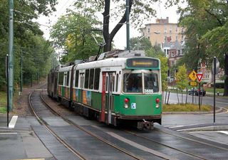 The dead giveaway is the Kinki-Sharyo Type 7 light rail vehicle in the background: It bears the unmistakable silver and teal paint scheme of the Massachusetts Bay Transportation Authority’s Green Line in and around Boston, Massachusetts, U.S.A. A quick scan down the street with Google Maps’ satellite view looking for a courtyard with a fountain led me to 1209 Beacon Street, Brookline, Massachusetts. According to Google Earth, the second-floor window from which the photo was taken is at about 42°20’35.01″N, 71° 6’57.06″W.
 First, modern cars + right hand side = America. Then I saw the trolley. I could recognize that trolley anywhere: It’s the late 1980s rolling stock of the MBTA Green Line built by Kinki Sharyo, which they had to buy in an emergency because the Boeing-Vertol models were so terrible that they had to reinstate the PCC cars from the 1950s. Given that, the above-ground location narrows the scope even further to somewhere to the immediate west of Boston proper (i.e., Back Bay, South End, Beacon Hill, etc.).
 also be ruled out, for Huntington Avenue (which is where the trolley is grade separated up until about Brigham Circle, which it then becomes part of the road) is a wider road and has no trees lined to it. The vast majority of the B Line is also ruled out due to lack of trees and road layout, and after looking through the section of B Line of which this picture could have come from (the last three stops, basically, from Chiswick Road west), that can be ruled out as well. This leaves the C Line, of which almost the above-ground portion is based in Brookline, Massachusetts.
 major stop on the C Line, and where I briefly used to live), and the building from which the shot came from the south side of Beacon Street. Roving on Google Maps gives me a direct hit. From the street view, it was hard to confirm it due to some excess greenery, but the red building across the street (the Holiday Inn Boston-Brookline) gives me the confirmation. Thanks to someone leaving some registered addresses, I’m going to take a stab: 1207 Beacon Street, just off St. Paul Street and its respective stop.
 Street by an iron fence, brick and stone posts, a fountain, and private gardens. Richmond Court was designed by Ralph Adams Cram who went on to design All Saints Church, further west on Beacon Street, as well as the Cathedral of St. John the Divine in New York, and many buildings at West Point and Princeton University” … which included the monstrous chapel opposite McCosh Hall, where I used to work.
 that the Richmond Court units would turn out to be individually-titled owner residences. Alas, Richmond Court appears to consist of rental units – good for affordable housing, but bad for me. Ultimately, I cannot say which apartment number this is, or who rents it, since rental lease documents are not public. The entire building and its land appear to be owned by a trust. No doubt the historical significance of the structure and its status on the National Register have thus far prevented a condo conversion. In any case, if I Google “1211 Beacon St” with “Brookline”, I find that a doctor and a couple lawyers have recently lived in the units with the 1211 address. That’s Brookline!
 pristine as the courtyard looks right now, you should see it on Marathon Monday. This building is on Mile 24 of the route, and it seems like every person in the buildings invites their 50 or 60 closest friends over to celebrate. Start early, stay late. Super super fun. Epic disaster on Monday night. I miss living there already!


 over and get the exact address now. [next email] I couldn’t see the exact number, but Google says it’s 1223 Beacon, so I’ll go with that. It was definitely taken from the second floor, probably the back corner window as seen in my poor quality iPhone pic.
 My wife and I just moved to Boston, so imagine our surprise and delight when our favorite photo game hit so close to home! We immediately recognized the green line train and knew the image was captured in Boston. As a fun little Saturday diversion, we decided to walk to Cleveland Circle (the end of the C Line) and take the train until we found the exact spot. We probably looked a bit ridiculous peering out the windows of the train, or maybe we just looked like your garden variety Boston tourists, but we finally found the building on Beacon Street in Brookline.
 the exact address. The window in question is at 1211 Beacon Street, St. Albans Hall, part of Richmond Court. A plaque on the wall mentions it’s in the National Register of historic places and was completed in 1898. I’ve included a picture of the window from the courtyard.
 Long time reader, first time participant. While I wouldn’t know
  visit to the site to take some pictures. In the few minutes that we were there, another couple arrived also to take pictures of the window (they asked us “are you guys here from View From Your Window too?”). I’m guessing that your inbox this week is going to have more than a few winning responses containing photographic evidence.
 with Boston, which surrounds Brookline on three sides. This is my first contest, and I don’t have any funny ties to the picture, other than I live just down the street and I’m pretty sure my dog has relieved himself in front of that courtyard. And how can you say no to this face?