The View From Your Window Contest

Vfyw-contest_9-4_

You have until noon on Tuesday to guess it. Country first, then city and/or state. If no one guesses the exact location, proximity counts.  Be sure to email entries to VFYWcontest@theatlantic.com. Winner gets a free The View From Your Window book, courtesy of Blurb. Have at it.

The View From Your Contest, Ctd

by Chris Bodenner

Recently I asked readers if they had any good ideas for presenting the VFYW guesses in a cool and dynamic way.  We have received a ton of really great suggestions – thanks!  I am still testing several of them to see which works best with the Dish.  Below are some of the leading contenders.  Hopefully one might be useful for a project of your own.  A reader writes:

Not that I ever have any luck at guessing, but I do love the VFYW contests and I think I have an idea for your map. Why not get together with the great folk at WorldMapper (or even do it yourselves if you have the know-how) to develop a map that expands the area devoted based on guesses? Since I hope that you get more “close” guesses than not, the region around the correct spot would be blown up and allow people to more easily see all the close guesses. Besides, who really wants to waste all that space on the map to those of us who couldn’t even get the right hemisphere.

Another:

OpenHeatMap might fit your needs. All you need to do is create a Google spreadsheet containing your guesses, and it handles the rest. (Here’s a two-minute guide for journalists.) As a long-time Dish reader, I’m happy to customize it if it doesn’t do exactly what you want.

Another:

I’m a longtime reader of the blog and a big fan of the VFYW contests. I work as a product manager at a web/search company and I’m a computer scientist by training. Here’s one way to dynamically create markers on the map:

1. I can build you a JavaScript widget that you insert into these contest result posts.
2. The JavaScript analyzes the page’s content on the fly and identifies all the place names on the page (this is not foolproof but quite easy to do)
3. It geocodes each place down to lat/long using the Google Maps API
4. It draws the map on the fly, directly into the page.

I’ve got a similar service that does this for food bloggers (identifies restaurant names in content and converts them to points on the map), I’d be happy to customize it for this use case if you are interested.

Another:

Apple’s iMovie has a mapping tool which creates animated “flight tracks” between geographic points you specify that you can intercut with the window photos in each location.  Of course, it’s not very interactive.  Perhaps check out a geomapping program like ArcMap, where you can tag each location with the corresponding photo.  I’m pretty sure that ArcMap now has a web creation utility.

Another:

Why not save the guesses in a file readers can simply download from your website and then overlay on Google Earth?  I don’t know if The Atlantic would be able to support that, but a host site shouldn’t be too hard to come by.  For my job I’m always using Google Earth and have multiple files I can simply open and close at will so the map doesn’t get too crowded.  You can even color code the markers if you want to get really fancy.  It takes a little work (but is not that hard once you get the hang of it) and it’s an easy way those of us at home can get a good first hand feel for the guesses that week.

Another:

Google Earth is an obvious choice. You can create “virtual trips” and embed each picture at the actual point it was taken, with any added textual comments you wanted. (Here are some examples related to literature.) Then save it as a kmz file, and people could upload it to their desktop Google Earth. Though that might be more work than you (or your readers) want to do.

Another:

Use Google Charts with world maps. It is a little more work, but here is what you could do:

1. You can mark the countries with most guesses in a different color. Or use darker and lighter shades for more guesses.
2. You can still mark the locations which people guessed.
3. You can mark out different regions within the same country.

Another:

Tableau Public. This is a great, free visualization system aimed at web publishing, and for something so sophisticated it’s fairly easy to use.  I think it’d be a good choice for showing geographical data like this.

Another:

There is a tool called Map Builder that lets you add markers on a map and add information on each pointer. You can see it in action here. We have also occasionally used BathGeo, which lets you paste in data from a spreadsheet and spits out a map. The former is a bit cumbersome, but useful if you want to display the various windows featured in VFYW. (For instance, if you want to link to the window.) The latter is better for a quick map.

Another:

Ushahidi builds tools for democratizing information, increasing transparency, and lowering the barriers for individuals to share their stories. It’s currently used for crisis mapping and election monitoring, but can be used for anything.

On a somewhat related note:

A couple weeks ago someone explained how they had created a VFYW fantasy league, and I was wondering if you guys have had others who’ve mentioned the same thing – have created leagues, were looking for other participants, etc.  I’m contemplating creating a VFYW Facebook page, but as a semi-slacker I was hoping someone else has gotten around to doing it first. In case I do create the FB page, do I have (or need) your permission do it?

No permission needed! And a quick search of Facebook shows this group that has already started (though it appears closed to the public). Send us a link at vfywcontest@theatlantic.com if you end up creating something – on Facebook or elsewhere.

The View From Your Window Contest: Winner #13

Vfyw-contest_8-28

by Chris Bodenner

A reader writes:

Now you guys are getting your act together.  This view will get guesses on all continents I imagine.  I’ll have to go with Malaysia, Kuala Lumpur.  Reason is, I have friends from India and China.  They have spoken to me about how they have personal drivers for their cars, as many people do there.  The little booth in the picture in front of the house would seem to serve this purpose.  But, I’m caught at a crossroads … China or India?  I”ll split the difference and say Indonesia.  Looking forward to the guesses.  They will be varied in global scope.

Quite prescient. Another writes:

This is San Francisco’s Seacliff neighborhood, on El Camino del Mar. That’s the Marin Headlands in the background. San Francisco Bay is hidden behind the houses.

Another:

At first glance, the picture looks so much like Southern California that it seems too obvious.  It must be one of the Inland Empire suburban developments that helped fuel the housing boom and bust.  But wait a minute – are those bars on the windows? A guard shack? That car isn’t American.  So I don’t think this is So Cal. But the mountains and perhaps Norfolk pines make me think the climate and typography are similar. Cape Town, South Africa would fit the mountains, climate, and car.  That’s my guess.

Another:

I’m going to go out on a limb and guess the Observation Neighborhood in Cape Town.  After my heartbreak last week at finally being successful at identifying the exact location of the towers in the picture, only to find out it was the easiest contest yet, I don’t have the heart to scour the globe finding the exact locale.  I’m going only with my gut. Hats off to those who discern the exact locale.  I will console myself with the knowledge that I am continually outdone by some of the most well-read and well-traveled blog readers on the internet.

Another:

I’m so intimidated by this contest. I wouldn’t know the first things about how to research this picture, but it reminds of of the summer I lived in Guadalajara, Jalisco, Mexico. I lived in a nice neighborhood, Colonia Providencia, and all the houses had gates like the ones seen in the picture. (With my luck, it’s probably from New Zealand.)

None from New Zealand this week. Another:

The houses and the pine trees in which they are nestled all remind me of a high-class neighborhood in Tunis, Tunisia. If this guess is correct, the mountain in the background is Mount Ressas. The only detail that throws me off is the little guard tower in front of the house; I don’t remember seeing those on my visit, so I am probably totally wrong.

Could I have the book anyway, please!? Two contests ago I mentally guessed the one from Sardinia, without writing an email. Does that count?

Nope, sorry (though the reader’s address is from Sardinia). Another:

This picture reminds me of diplomats row in Shihlin, Taiwan, north of Taipei.  I remember walking along several similar streets going door-to-door as a missionary back in 1999.  The National Palace Museum is nearby and there was a great noodle place along the way.

Another:

I have seen neighborhoods like this one in Lagos, Nigeria and Kigali, Rwanda — places where privileged classes are building (but not always completing) gaudy villas, while at the same time becoming more fearful of where they came from (as evidenced by the guard post). But the residents of this street do not perceive themselves as in quite so much physical danger as in Kingston, Jamaica, or Johannesburg, South Africa, where the fences would be higher or sharper and the gates closed shut. Also, the absence of palm trees suggests a more northern climate. Almaty, Kazakhstan?

Another:

This is Arab – by the architecture, and the guard boxes in front. Based on the mountains and the Mediterranean pines, I would say Lebanon. The guard boxes would say the diplomatic quarter of Beirut. However, the wealthy in Lebanon also have guard boxes, equally empty, so it could also be Jbeil. I’ll stick with Beirut.

Another:

It looks like Ankara, Turkey. I stayed in the Cankaya District for two weeks and saw a few of those guard shacks while walking some very steep roads in that area.

Another:

First, thanks for doing these.  Like a good crossword, they’re hard.  But if you stare at it long enough the clues start to show themselves. That’s the best kind of puzzle.  Anyway, my guess: I’ve narrowed it down to the Malaysian suburbs somewhere in the mountains.  Beyond that it’s a proverbial dart at the Google map, which landed here: 2-42 Jalan Selasih Taman Cheras, 56100 Kuala Lumpur, Federal Territory of Kuala Lumpur, Malaysia. I assume your knowledge of Malaysian geography is as bad as mine, so here’s a link.

Another:

My guess is an eastern “suburb” of Mandalay, Myanmar. The hills in the background would be the Shan Hills; both vehicles are white, a common colour choice for cars there, and the license plate is black. The guard houses and walled compounds are also familiar. The person in the driveway also appears to be wearing a longyi, normal dress for Burmese males. That said, the longyi is white, not a common colour, so perhaps this is from Pakistan or somewhere in Northern India.

On the right track. Another:

Tropical flora, but also pine trees; flat landscape with steep mountains in the background.  Person appears to be wearing all white (cotton?).  My guess — northern India; specifically, Chandigarh (since a le corbusier designed city seems like something the Dish would lean towards), looking north east towards the Himalayan foothills.

Getting really warm. Another:

Normally I zero in on details in the photos, like everyone else, and scrutinize the tiny hints to narrow down a guess.  For this scene, it popped up and I instantly thought, “Kabul, Afghanistan – probably the neighborhood of Wazir Akbar Khan.”  The guard posts outside the houses were a give away, plus the familiar rugged mountains in the background, which section up the city.  Also the seemingly new construction (the house in the middle with unpainted masonry).  Perhaps the small figure in white is wearing a salwar kameez.  I spent time a few years ago working at Kabul University, which is pretty far from “Wazir” where I spent limited time, but enough to feel pretty confident about this one.  Until recently Wazir was one of the safest parts of town, where a lot of internationals live.

Closer still. Another:

The homes look made for security and privacy, which suggests to me a predominantly Muslim country with perpetual security angst, plus green luscious mountains.  Pakistan was my first thought.  There’s also the guy wearing the white kurti. Probably a city, because it looks pretty affluent, and Karachi doesn’t have the mountains, so: Islamabad, Pakistan.  I’m guessing somewhere on the northern part of the city looking north at Margalla Hills National Park.

Correct! But which sector of the city? Another:

This week I’m convinced the VFYW is of Islamabad. The houses at first appeared very South Asian to me, and the glimpse of the cars and the man appearing to wear a kurta made me sure of it. Islamabad is among the few well-developed South Asian cities nestled among the mountains, and the pine tree gives away the alpine location of the city. I imagine the hills in this picture are the Margalla Hills. Finally, to narrow down on the neighborhoods in which this photo could be taken, I think the photo is either from the posh sectors E or F, especially evidenced by the little security guard kiosks located just outside each gate.

But is it E or F? Another:

This is my first submission, but I think I have a shot. Initial key things I noticed were the license plate (there are black ones in Pakistan), and what appears to be a fellow in a shalwar khamis.  The topography and foliage remind me of Islamabad, along with the architecture and the little guard houses. The view is looking toward Margalla Hills and the Faisal Mosque, possibly from the E-7 section of town – but I cannot find the houses or view on Google Earth (I am sure someone will, but I have to go walk the dog).

You can blame this loss on the dog then. The winner:

Here goes my shtick for why I think the pic is possibly a rich suburb or neighborhood in Islamabad. (By the way, such a nice view compared to the horrors of the flooding happening elsewhere in the country.)

The style of construction seems like what I’ve seen in the area, as well as the security huts and gates. Checking the Google terrain and some pics in the area, I would say it’s near the area called Christian colony, possibly near the Danish embassy. The hills appear to be the Margalla hills seen from F-6 area of Islamabad. Ok, that’s my guess.

The house in the photo is specifically located on Street 40 in Sector F-7/1 – which is just a hair closer to F-6 than E-7:

Islamabad, pakistan - Google Maps_1283243295764

Congrats to the winner, who gets a free VFYW book. Below are a few more of my favorite Islamabad guessers (who numbered 12 out of about 150 overall guessers). One writes:

So far as I know, those stupid little security booths are not found anywhere else and the mountains in the background look just like the Margallas. Also, the guy in the picture looks like he is wearing a shalwar kameez. And finally, the completely eclectic/random mix of architecture is oh so Islamabad.

Another:

My name is Mark and I’m a VFYW addict (when will we get a midweek fix?).  This is definitely … possibly … probably not … Islamabad. The small guard houses, the chap standing in the driveway wearing a shalwar kameez, the hilly topography, the Chir pine tree, the black number plate on the left-hand drive vehicle and what appears to be minarets in the background (though I might be seeing things – it’s part of my addiction). Today I’ve spared myself the “joys” of Google Earth. Nothing like scouring a city for an hour only to discover that you were a continent away.

If it’s any consolation to the near-winners, we keep track of people who have guessed correctly. In a close tie, victory goes to a correct guesser in the past.

By the way, I just spent more than a half-hour plugging all 150-odd locations into Google Maps, only to have Safari refuse to accept my screenshot software (Safari sucks in general; use Firefox) and then delete all the locations when I tried to log in through Firefox. I may get a burst of energy to do it all over again and post the map, but here is a rough rundown: the most common locations were Cape Town and Beirut; a notable number from Kuala Lumpur and Bogota; an inordinate amount from southern California; a good number from Mexico; a smattering from South America; a handful from Europe … you get the idea – scattered all over the world. My favorite was Schenectady, New York.

The View From Your Window Contest

Vfyw-contest_8-28

You have until noon on Tuesday to guess it. Country first, then city and/or state. If no one guesses the exact location, proximity counts.  Be sure to email entries to VFYWcontest@theatlantic.com. Winner gets a free The View From Your Window book, courtesy of Blurb. Have at it.

The View From Your Window Contest: Winner #12

Vfyw-contest_8-21

by Chris Bodenner

A reader writes:

I dated a German girl for a few years, and so spent plenty of time in various parts of Germany and Austria. The architecture from this photo is very familiar. It’s clearly Bavarian. So I’m going to go with the longtime capital of the former kingdom and now Bundesland: Munich.

Another writes:

This one could be anywhere in southern Germany, eastern Switzerland, or Austria, from my eye.  The church tower is very typical of that region and I think I’ve seen them in towns along the Donau.  The square tower nearby also generally fits my hazy memory of an architectural style from that region.  The buildings in the back argue for a large-ish city, and the spike tower in the far background could possibly be the needle from the 72 Olympics in Munich (or just a crane, hard to tell).  How about somewhere south of Marienplatz?  My wife promises me a dinner if I ever get one even close enough …

Another:

It looks like the city where they shot the last scenes of Willy Wonka and the Chocolate Factory – Nordlingen, Germany?

Another reader thought the same thing. Another:

This one was deceptively difficult.  It feels like this should be in Germany, but for the life of me, I can’t figure it out.  I’ve spent more time than I’d like to admit pouring over databases of high-rise buildings trying to place that angular glass building in the background.  I thought the small flag in the foreground could point towards a location, and now I know more about Germanic heraldry than one person should ever have to learn (I’m now convinced the flag just decor).  And with all that, I have naught but a guess: Bremen.  (I know, I know, not even close…)

Another:

The picture looks very much like Sweden, although it could conceivably also be in Russia or Georgia. If I had to guess, I would say Visby, Sweden. A quick Google image search reveals quite a number of churches and other building remarkably similar to those picture.

Another

I am going to guess Cordoba, Spain, near the river there is a fort like building in the old section of the city. The buildings in the foreground remind me of the architecture there, while the modern buildings in the far background look like they would have been built in the construction boom in recent years.

Or too much mosque on the brain. Another:

Wow, this one is obviously from Catholic East-Central Europe, but where?  A million cities flew through my mind, and my gut says “Prague”, but I think this is too obvious.  Still, it’s somewhere that has seen some strong recent economic development – those are obviously capitalist and not communist high-rise buildings in the background. I’m going to go with a dark horse and guess Vilnius, Lithuania (homeland of the ancestors on my mother’s side of the family).

Another:

I believe the picture is from Riga, Latvia. My first guess was Brugges. But my husband, who has been to Brugges, shot down that idea.  He insisted it was Germanic-style architecture. I noted the flat landscape, the lack of skyscrapers and the Russian-y look to the steeple.   Latvia popped into my head, and I googled church steeples in Riga (the only city I know in Latvia) and found an image that looked very close.

Another:

Prague, Czech Republic? I’m pretty sure that red-and-white stripey thing off in the distance is the Žižkov TV tower. And the mix of old-timey and modern architecture more or less comports with the city as I remember it. Even if I’m right, I know someone else is going to be able to identify the location down to the exact GPS coordinates. Or else it’s some tiny suburb on the outskirts of the city, where one of your readers lived for a year. I tell you, I continue to find this contest both exhilarating and despair-inducing.

Another:

Lisbon, Portugal.  I have my reasons.

Another:

I checked the Dish from my office one afternoon not long ago and the VFYW photo showed the very building I was sitting in at the time, taken from someone’s apartment window across the street. How cool is that? Why couldn’t that have been the first contest photo?

Another:

Finally got one.

Although I suspect this one will be very easy and lots of people will get it and someone will get the angle/location of the shot much more precisely. At first I thought Bavaria and searched Bavaria and steeple in Google images.  This yielded some similar things, but no hits.  Then I tried Czech, the Slovakia … closer.  Then I gave up.  But after a walk and brunch, suddenly the thought Estonia popped into my head.  And there it was!  St. Nicholas Church in Tallinn, Estonia.

I figured this week’s contest would be relatively easy, but not this easy: the vast majority of entrants guessed Tallinn (out of about 300 total).  For that reason, a map of the plotted guesses wouldn’t be that interesting this week. (Plus, I’m still sorting through all the great suggestions for dynamic maps sent in by readers – thank you!).  Below are some of the best entries for Tallinn. One reader writes:

At last, I’ve finally been to one of the featured window views!  So we have St Nicholas’ Church, Old City, Tallinn, Estonia. To quote the tourist blurb: “Founded by German merchant/settlers from the island of Gotland sometime around 1230, the sturdy church was designed to double as a fortress in the days before the town wall was built.” The church is well known for its organ recitals – they were pumping out the tunes during my visit in ’08. I could put GPS coordinates up and post pictures but hey, I’m just happy to be in the right country for a change!

Another:

The window the photograph was taken from is somewhere around 59°26’10.90″N, 24°44’26.45″E.  Here is the result once I determined this location:

Tallinn-image001

Thank you very much for this opportunity to dedicate a whole day of sleuthing.  It was great fun!  Hopefully I’ve come fairly close.  Maybe one day I’ll actually get to visit the area.  It looks really interesting.

Another:

The street address is Niguliste 3, 10146 Tallinn, Eesti. The Wikipedia page is here. My wife and I took a roundabout path to the answer.  We instantly, though mistakenly, placed this scene in Central Europe, where we have traveled a bit.  The ornate Baroque tower reminded us of that area.  In the background is a bit of wall, and that inspired my wife to search Google for images of German walled cities.  The first picture in her list showed the church from nearly the same angle, although much further away.  (The linked site was this one.)  We were shocked to find out it was in Tallinn.

Another:

I was terribly excited when I saw this photo, because my wife and I spent the last four days of our honeymoon in Tallinn, two winters ago. I’m browsing our photos, because we have a few that are nearly identical to this shot. We were there in January, when every storm creates the closest approximation you will ever see to a life-sized snow globe. Thank you for posting this!

Another:

I’m the commissioner of the “superfan” league you wrote about here. I’m sure there will be quite a few Tallinn win editguesses of the correct answer (Tallinn, Estonia), but my girlfriend and I are confident we’ve nailed the exact coordinates:  56° 26′ 10.77″ N  and 24° 44′ 25.97″ E.  Here’s the Google Earth view of the spot!

Since I last wrote, we’ve turned our league into a “head to head” style VFYW league, similar to fantasy football, where we have matchups each week and standings based on wins and losses.  At the end of the two month season, we’re doing a seeded playoffs where the top seeds have a mileage spread!

By the way, as a Latvian, it’s good to see you represent the Baltics. (Side note: the most attractive people in the world come from the Baltics – true statement!)

Another:

This one is too easy for us readers of Estonian descent, of which I suspect there are many.  By the way, Estonia and Estonians tend to favour your brand of principled conservatism – the government is small, sensible and low-cost.  It is often recommended as a model, but only really works when the governed are also pragmatic and stoic, as Estonians tend to be.

Another:

I still have a bottle of Vana Tallinn not 5′ away from me that I brought back after my 1995 visit to Estonia while on study abroad. Such a magical place with the old historic city walls still well preserved. It was like stepping back in time – I seem to remember the old historic pubs the best, don’t remember much about the churches. Perhaps it was the drinks we had of Vana Tallinn with 45% alcohol that made the place seem so magical.

Another:

This took no time at all.  The tower was distinct, so I knew I had a good chance. First, I latched onto the tiny flags topping the church steeple and the medieval tower.  But a Google image search of church and city flags got nowhere.  Then I decided (maybe foolishly) that the number of towns with a church right next to a medieval wall must be relatively finite.  I googled “Churches near medieval walls.” That worked.  Incredible.

Jackpot on page 3 of the results, courtesy of this website. Specifically, the black and white church tower is located at 59.435922, 24.742756.  It is called Tallinna Nigulste Kirik.

So!  I’d found Tallinn in 15 minutes.  The rest was Diff-anglean hour (or, uh, twice that) trying to pin down the angle to find the right window.  For this, the Google Earth feature is awesome.  It let me zoom through a 3D virtual Tallinn and line up the triangular building and red-and-white smokestack in the background. In my exploring I also found that under the red-topped tower is a cafe that sells pottery, called Bogapott.  Bogapott has an encouraging website.

In the end, I decided the VFYW photographer (assuming he or she followed the rules and took the photo from a window) was on the second floor right here: 59.436348, 24.740658

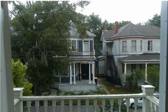
I’ll let those coordinates be my official official guess coordinates.  Google doesn’t really give an address for the building.  The corner building (corner of Pikk Jalg and Piiskopi) may be Pikk Jalg 16. Attached is a photo looking East along the front yard of 16.  To the left, you can see what is likely the VFYW foreground tree, the photographer’s window out of frame.

Two final notes.  First, given this technology, in 5 years we won’t be able to play this game at all; it will be too easy.  We’ll be able to pinpoint any spot on the planet in 10 minutes.  And secondly, I did all this on Saturday morning, when there were 3 or 4 decent photos of that area of Tallinn pinned to Google Maps. When I went back to Google Maps on Monday afternoon, I discovered what seemed to be dozens more photos pinned there. Meaning, I take it, that plenty of your readers uploaded their photos over the weekend.

Another:

Thanks for helping a couple of 911 dispatchers keep alert on a slow Saturday.

Another:

I usually give up on this contest after about ten minutes, but today I have a new puppy and too much time on my hands.  Using Flickr and Google maps, I was able to narrow down a city with red roofs and black steeples.  After a few more minutes,  and after considering both St. Nicholas church and St. Olaf’s as the steeple, I discovered it was actually the medieval town hall, or ratusz, in Tallinn Estonia: 10146 Tallinn, Estonia 645 7900. Apparently people used to be executed in the town square directly in front of the building.

Another:

Wow, check out this cool website:

55A0

You can see the view almost like your photo. And it’s a 360 shot, one can play with it. Wonderful.

Another:

This isn’t an actual entry into the contest, as I found the answer by cheating and wanted to let you know how.  Using the Google Goggles app on my phone, I took a picture of the tower in this week’s photo.  Goggles was able to match that to another photo from Tallinn that happened to have the same tower.  I went through a few other VFYW entries and wasn’t able to cheat on those, but I just wanted to let you know that this sort of thing is possible.

Disclaimer: I’m an engineer at Google and I work on Goggles.

Another:

The reason I am choosing Tallinn is because the steeple and tower in the picture appear to be the same steeple and tower that were seen in another VFYW picture that you Tallinn_estonia
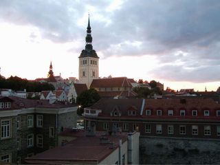
had narrowed my guess down to England or Eastern Europe.

I’m not going to try to guess exactly what window this view came from, but I’m sure some of your other readers will (especially since I’m sure you have readers who live or have lived there, or visited the church on vacation, or had their first kiss in that very steeple, or …). I’m glad that you print some of the e-mails from people who have guessed; it is so enlightening to see the details they are picking out in order to guess the location. And no matter how many details I pick out to guess the location, your readers always pick out many more that I have not even noticed.

Another:

That’s definitely Tallinn, Estonia – though I may have an unfair advantage, having submitted a similar photo that was featured in August 2008.

Another:

Since this will be more a test of one’s ability to stand out in the crowd than a real contest to get the correct answer, I’ll start off by making this a little bit about me.  [600 words later …]  So, how to distinguish myself Me in tallinnfrom the many correct answers?  Sadly, I probably shouldn’t use the google maps screenshot on which I marked up the field of view because that might present copyright issues.  I don’t have much of a personal story about the location.  Although I can say I was there, on a very pleasant warm summer day three years ago, I didn’t get married there or otherwise mark the moment in any sort of spectacular fashion, and it’s probably too late (or too expensive) to plan something between now and Tuesday.

Best I can do is send along the attached photo evidencing my visit to Estonia, as to which I can say without question I own all copyright and hereby give you full permission to use. That’s the best I can do.

Gosh, I love this contest.

So many inventive and accurate answers, but we have to choose one.  So the winner of the free Blurb book goes to the following reader, who not only nailed one of the most difficult prior contests (Dili) but who also included an excellent window view – not too vague, not too obvious, several intuitive clues – to use for a future contest. (One of the most challenging and time-consuming aspects of crafting a contest is finding suitable windows from the limited number of unused photos sent to us.) The winner writes:

This time you’ve selected a picture which is simply too easy.  I’m betting 200 entrants get it correct.  This is going to be my third correct entry (I’ve previously gotten correct the photos of Dili, Timor L’Este and Sarajevo, Bosnia & Herzegovina).

In the photo this week, the architecture is clearly Baltic.  I’ve been previously to Riga, Latvia, and Vilnius and Kaunas, Lithuania, the other major Baltic cities, and I thus know it’s not a view of any of them.  So I presumed it must be Tallinn – which I haven’t visited.  All you have to go is google images of Tallin and it’s clear this is a view of Tallin’s old city.

Make it harder next time.

You can count on it.

The View From Your Window Contest

Vfyw-contest_8-21

You have until noon on Tuesday to guess it. Country first, then city and/or state. If no one guesses the exact location, proximity counts.  Be sure to email entries to VFYWcontest@theatlantic.com. Winner gets a free The View From Your Window book, courtesy of Blurb. Have at it.

The View From Your Contest

by Chris Bodenner

We added a new feature to the window contest today if you missed it below the fold:

Vfyw-map_sardinia

If you know of a cool and relatively easy way to present this information a dynamic way, please email us at VFYWcontest@theatlantic.com. A free window book to the reader whose idea we use.

The View From Your Window Contest: Winner #11

Vfyw-contest_8-14_

by Chris Bodenner

This week’s puzzle was the least participated yet, likely due to the August lull, Andrew’s absence, and the level of difficulty. A reader writes:

Not an easy one, is it? The roofs and shutters suggest southern France, or possibly northern Spain. I am gonna go with southern France, and just to make a guess: Languedoc region, possibly Corbieres mountains.  Lezignan?

Another writes:

Now, we’re talking.  I’m still waiting for an image of such obscurity that no one possibly could imagine what it is.  This is close, but there are clues…

The blue sky, shingles on roof, water in the background, and well-made wood doors indicate Mediterranean origin.  I was tempted to choose a Greek island, given the blue laundry hanging in the background that matches their flag.  (Europeans do not like displaying flags after the wars, but perhaps there is a subliminal draw to the color.)  But I’ll have to choose Spain.  The wood doors and black shudders look old-Spanish.  Low vegetation in the background would seem to indicate one of the Balearic Islands.  For an English readership of the Dish, I’d have to lean towards Eivissa.

Another:

I have no fuckin’ clue. Although, I will say the thing that came into my mind first was the courtyard/rescue seen from the In-Laws with Peter Falk and Alan Arkin. I think they were in Honduras … so I’m going with Honduras for this very valid reason. Wikipedia tells me the capital is Tegucigalpa, so that will be my city.

Another:

This is a tough one for sure. My gut feeling is that this photo was taken on a Greek island.  There is a hint of water in the background, indicating a rocky shoreline.  The place is obviously arid, hot and sunny, with scrubby vegetation.  It could be any number of places along the Mediterranean, but Greece seems most likely.  However, with some 9,000+ miles of coastline, I don’t even know where to start. So I’m just going to throw Crete out there as my final answer.

Another:

I wasn’t far off on Sarajevo. I had Savannah within a few blocks. But when I looked today, I had no blessed idea where to start. My husband leaned over, took one look at my screen and said, “Sicily.”  So hey – I’ll go with that.

Another:

Architecture and landscape suggest Italy. There’s a beach in the background, and based on the shadows, I’m going to guess that the beach is on a northern coast. The hills don’t match the southern Adriatic coast, and the architecture lacks the Venetian influence of the northern Adriatic. That leaves Sicily or one of the smaller islands nearby (just doesn’t feel like Sardinia). When I went into Google Earth, I couldn’t find any towns on Sicily that quite matched the orientation of the beach shown in the picture. But I found one on Isola Lipari, so I’m going to take a stab at this and say Acquacalda, Italy.

Another:

It looks just like a building from a spaghetti western, so I’m going to guess suburban Granada, Spain.

Another:

Mallorca, Spain? The un-whitewashed shallow-sloping buildings look like solidly southern European farmhouses, or at least buildings that have been constructed in an old farmhouse style. The landscape – rocky, arid and treeless – looks more like Spain, and I think the complete lack of trees suggests one of the Ballearic islands. I found a few pictures using Google, of similar buildings in Mallorca. Even if I am right, I don’t have the local knowledge or the fortitude to really dive deep and identify the exact location using Google satellite view, so will leave that to someone else!

Another:

This is the hardest yet!

Perhaps I’m missing some locality specific clues?  Stucco and red tile roofs; dry summer weather but not tropical vegetation. Compound is raised a little above a bay.  Where do they have such compounds these days?  That’s not clear.  The housing seems rudimentary though it has modern electricity.  But old buildings and water trough.  Is that a laundry cart on the balcony on the left?  A hostel or inn at some Mediterranean beach – but the grounds aren’t very well kept.  I spent at least ten hours touring what seems like every bit of the coastline of the Med with Google Earth – as well as the close-by islands (and Mexico!). Since Google Earth is insufficient in some areas to identify specific house types, I know I didn’t cover everything.

In the end I found little evidence of compounds like this and it seems to me that the modest beach buildings of yore in Europe have given way to relatively upscale housing.  At some point, my mother, who has been getting quite involved with these contests, called to say she had seen a travelogue of Madeira and it reminded her of this picture – the same types of houses, hills, etc.  Unfortunately, the travelogue was probably from the ’50s.  So, even though I did not see this site on my several trips around the island, I’m going for the island of Madeira, which belongs to Portugal.

I hope “ten hours” was hyperbole. Another:

Very typical Corsican shutters and red tiled roofs. Rough Mediterranean terrain is from the northwest part of the island. I’m going with Calvi, Corsica, France.

Getting warmer. Another:

Sardinia!  Buildings look Italian, roof tiles look Italian, shutters, windows and doors look Italian, hinges look Italian. Landscape in the distance looks like rocky, low lying green brush, thorny, sun-drenched Mediterranean. Angle of photo could be looking north, which would put us on the west coast because of the slightest sliver of water to the right, which clearly puts us smack dab…

WAIT! Suddenly, Sardinia seems too wealthy for this photo. Something about that shack in the center middle-ground says Sicily instead of Sardinia. And the windows on the two foreground buildings – a little more worn, a little more closed up, a little more weary of life… But something about the portal in the courtyard wall seems more Roman that Sicilian? Google maps along the southwestern coast of Italy are too poor to conclusively pinpoint the location.

So I’m heading back to Sardinia. And since I have to get back to work, I’ll say Buggerru.

Oh so close. Another:

Such a sad little courtyard! I hope the potted plant on the right makes it through the summer. I’ve toyed with a few island and coastal locales along the Mediterranean, but I’m going to have to go with Sardinia, Italy, near Alghero.  I know, I know, I’m a zillion miles off!

About 80, actually. Another:

I am a sailor in the U.S. Navy, and I lived in La Maddalena, Sardinia for 11 years, from 1995 to 2006. I was stationed aboard the submarine tenders USS Simon Lake (AS 33) and USS Emory S. Land (AS 39). (The Navy no longer has a presence there, as everything was shut down and the ship sent back to the States in 2007.) La Maddalena is a small island in the Maddalena Archipelago located at the northeast tip of Sardinia; the largest town on the island is also called La Maddalena. The sub tenders were actually located on another small island, Santo Stefano, which is less than a kilometer from La Madd.

Anyway, as soon as I saw this week’s window, I felt homesick. The terrain in the image is identical to La Madd’s, and the building looked familiar, like one I used to pass while walking to the beach. After some googling and Google Earthing (which made me even more homesick), I believe the view is from Residenza Cala Francese, 07024 La Maddalena, Sardinia, Italy, looking north-northeast. Some better pictures of it can be found here.

I feel pretty confident about this one.

As you should – congrats!  We’ll get a Blurb book out to you shortly.

For a while now, I’ve been meaning to find a good way to display everyone’s guesses, particularly in a dynamic way, but I haven’t had the time or know-how yet.  If any readers have suggestions, please email them to VFYWcontest@theatlantic.com. Here is what I whipped up with Google Maps (“A” marks the answer):

Vfyw-map_sardinia

Money zoom:

Vfyw-map_sardinia-zoom

See you Saturday for the next installment.

The View From Your Window Contest

Vfyw-contest_8-14_

You have until noon on Tuesday to guess it. Country first, then city and/or state. If no one guesses the exact location, proximity counts.  Be sure to email entries to VFYWcontest@theatlantic.com. Winner gets a free The View From Your Window book, courtesy of Blurb. Have at it.

Update: We switched out the first photo (from Delft, Netherlands) because of a revealing file name accidentally left it.

The View From Your Window Contest: Winner #10

Vfyw-contest_8-7

A reader writes:

Hmmm that’s a tough one.  Could be a number of American cities.  At first glance, it reminded of my old Atlanta neighborhood of Inman Park, but the houses are a little too close to the road.  I just got back from Rochester and it looks similar to some neighborhoods there.  Or it could be in Midtown Memphis, or Savannah, GA or just about anywhere.  Well, let’s just go with Rochester then.  It’s kind of a randomly nice place.

Another writes:

I think I’ve been down this street.  My guess is Washington, D.C. – Takoma Park.

Another:

The moment I saw this I knew exactly where it was.  The 19th Century French Architecture turned into cheaper apartment housing, the narrow streets, low hanging power lines, sleepy trees, tropical looking plants on the bottom right of the screen – all of these clues point to New Orleans.  Just imagine some beads hanging from those power lines to complete the picture.

Another:

ADT sign – USA
Ditto the huge, roll-away trash can
Ditto the architecture.
Big front porches – warm climate
Apparent lack of basements – high water-table, ergo seaside.
Palmetto trees.
Palmetto state?
South Carolina.
Charleston?

Another:

The “free classic” Queen Anne architecture is typical in the U.S.  (This style of architecture was popular in the U.S. from the 1880s through the 1910s.)  One of the houses has, at one time, been converted to have an apartment upstairs.  This was commonly allowed for in U.S. cities through post WWII zoning changes made to address the housing shortage at that time.

The one item that narrows this down is the plant material.  I think that is a small palm tree in front of one of the houses.  This limits the search to the coastal areas of the Carolinas Georgia, Alabama, Mississippi, Louisiana and Texas.  It also includes most of California and all of Florida.  I’m going with Jacksonville.

Another:

Palm tree suggests southern or possibly West Coast. There appears to be a crepe myrtle, which we have a lot of here in Texas. It’s been over 30 years since I was in Galveston, but I seem to recall that it had lots of similar cool old houses. My guess is Galveston.

Another:

Okay, the first item to narrow the search is the Live Oak, which is present from Texas to Florida and up to Virginia.  The next clue would be the Sabal Palms, which would suggest the Southeast.  Palms are typically present in Florida, Georgia and South Carolina.  Live Oaks, however, aren’t present in South Florida, so these two clues narrow things down to Central Florida up to South Carolina and west to the Gulf Coast. (What appears to be a maple leaf doesn’t help much because maples are present in too many places.)

On a hunch I’m going to narrow the area down to either Savannah or Charleston.  Given the age of the homes, it would likely be in South Charleston but the topography would indicate not on the water. Radcliffeborough neighborhood of Charleston is my final answer.

Another:

Ah, if only I’d seen this sooner.  I’m sure I’m the thousandth person to email this: Savannah, Georgia. I only know it because you’ve run a photo from the same window before.

Great memory (a better one than us) – and among only a few readers who noticed.  Others were more intuitive in their search:

The obsession item in this pic for my wife and I became the black recycling bins with the yellow lids.  Throwing in search terms yields a ton of results for Australia, which would have been a nice curve ball, except for the car and street sign giving away right-side drive.  No  front license plate either, so cross out Virginia.  So you’re back in the Deep South and googling municipal recycling programs on a Saturday night  (thanks for that, by the way).

I don’t love love love this answer, but based on what I can tell, a little location bias, and their use of black recycle bins (although I couldn’t confirm those stupid yellow lids!), I’m going with Savannah, Georgia.

Another:

My first instinct is that this photo was taken in Savannah.  And after Googling “yellow trash Recycle Savannah: Curbside Recycling_1281428759944can lid,” I found this article about a new curb-side recycling program in … Savannah!

This one wasn’t so difficult.  And I’d love to while away the afternoon searching Google Earth for the specific address, but instead I’m going to go enjoy this beautiful day, confident in the belief that — even though one of your readers will no doubt be more specific — I finally got one right!

Another:

I’m going to go with 21 E 39th St, Savannah, GA.  My first thought was a street somewhere on the Charleston, SC peninsula, but Spanish Moss isn’t very common in the heart of Charleston.  The architecture and foliage still indicate somewhere in the South though, so Savannah was my next guess.

But I figured I wasn’t going to be the only one to guess Savannah;  I’d have to find the exact location to have any chance.  So a brute force attack using Google and Bing maps was the plan – Bing’s Bird’s Eye turned out to be the most useful.  I had some clues from the picture: a south-facing two story, adjacent to another two story, close to the street. The style of roof helped as well.  Having visited Savannah before, I knew a little about the city’s layout and started my search south of Forsyth Park and somewhere between Broad and MLK, thinking that was the area most likely to have homes like the ones in the picture.

Bingo. Found them on E 39th Between Drayton and Bull.  Only took up about 45 minutes of my lunch.

Another:

Aargh!  This contest is as frustrating as two weeks ago, when I nailed Lausanne, but couldn’t find the exact spot in town on the ‘net.  I wonder if a decade from now there will be VFYW Anonymous groups spread across the country, helping each of us overcome our obsession.

So this week I’m using Google maps to virtually “walk” up and down street after street, crossing my fingers that A) I’ve got the right nation/city and B) I’ll come across the exact address before someone else does (probably someone who lives on the flippin’ block or something).

Another:

Oh, you couldn’t of made this any easier!  A couple of hours in the car looking in the Victorian District of Savannah and I finally found the house. The blue house is located at 16 East 39th Street, between Bull and Drayton Streets.

The house is in an area that has become know in recent years as the Starland District, owing to the fact that a dairy, the Starland Dairy, was located on Bull between 40th and 41th street. I grew up just south of this area. My earliest memories are of the horses and milk wagons leaving the barn and clopping down the street outside my bedroom window in the morning and returning in the afternoon. My brother went to the movies at the Victory theater, we brought gas at the Gulf station and I loved going to the Franklin 5&10 cent store all on Bull Street. Good memories from a long ago place. Thanks for the challenge and the stroll down memory lane.

Thanks to you – and everyone else who played this week.  As far as the winner of a free window book from Blurb, we have to go with the admitted VFYW addict who also correctly guessed Lausanne (one of our most difficult contests to date). Congrats!