Banaue, Philippines, 11 am
Banaue, Philippines, 11 am
A reader writes:
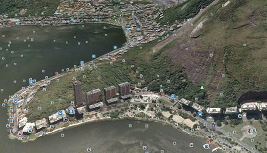
I think I may be on a winner here. The photograph is of the Derwent River in Hobart, Tasmania, Australia. The tall building across the body of water is the Hobart Casino. My hunch is that the photograph was taken from the Bellerive or Rosny neighbourhoods near Kangaroo Bay, on the other side of the river bank (but I don’t have OCD and won’t be pinpointing the exact location). I once drove around Tasmania with my family when I was a teenager. It’s a beautiful Island.
Another spins the globe:
This looks to be New York looking south along the Hudson. Maybe Stony Point.
And back again:
Yoros Castle, Istanbul, Turkey. I know that’s wrong, but this is somewhere on the Bosphorous, right?
Nope. Maybe it’s in South America:
I so wanted this view to be taken from somewhere around the Lagoa Rodrigo de Freitas in Rio de Janeiro in the shadow of the Christ the Redeemer statue. It looked so much like what I remembered when I visited there – from the high rise condos, to the rounded, partially bald mountains rising from the water.
I looked for hours for the possible angle, but the pieces just wouldn’t fall into place. I searched the Internet for ages to try an located the viaduct looking bridge on the side of the mountain. I looked for the oddly out of place Germanic looking building on the right hand side. No luck.
So, alas, since I have no better guess I will stick with it even though I am pretty sure it is in vain.
Another throws up his hands:
Dammit, Sullivan. A weekend wasted, yet I am completely stumped this week.
My first reaction to the picture was that the geographic features remind me of Lake Como, though the buildings are all wrong. I doubt it’s in the US, especially after two weeks in a row having American locations, though I can’t find anywhere else in Europe that matches. It somewhat reminds me of Canadian utilitarian architecture, but again, I can’t pinpoint where it might be. So I am going to go with a complete shot in the dark and say that it’s somewhere on Lago Maggiore in Italy.
Please: Consider starting some sort of support group or rehabilitation program for those of us who are completely obsessed with this game, but who don’t have the amazing capacity to find the location every week. (That and maybe marriage counseling for spouses who wonder why their lesser half spends the entire weekend staring at their screens trying to divine the clue that will unlock the solution.)
And that’s if you even want to find it:
This has got to be the saddest lakeside town I’ve ever seen. Seriously, it looks completely desolate and deserted. The architecture is very austere, nothing frilly or happy about it. I see something looking like a pseudo-castle-like structure on the bottom right, probably a some sort of hotel or restaurant. The most interesting feature is the ruined aqueduct on the hill. I searched for aqueducts throughout Europe, found no pics of that one. Above it, there seems to be a hotel, casino or cement factory. Again, uninspiring architecture, reminiscent of countries in the former Eastern block. I sincerely hope this is not one of the Italian lakes, even though I did guess that.
Another gets to the wrong lake in the right country:
Precarious rock ledge, Lake Rigi, Lucerne, Switzerland.
This reader, like most entrants this week, nails the correct lake, castle, and town:
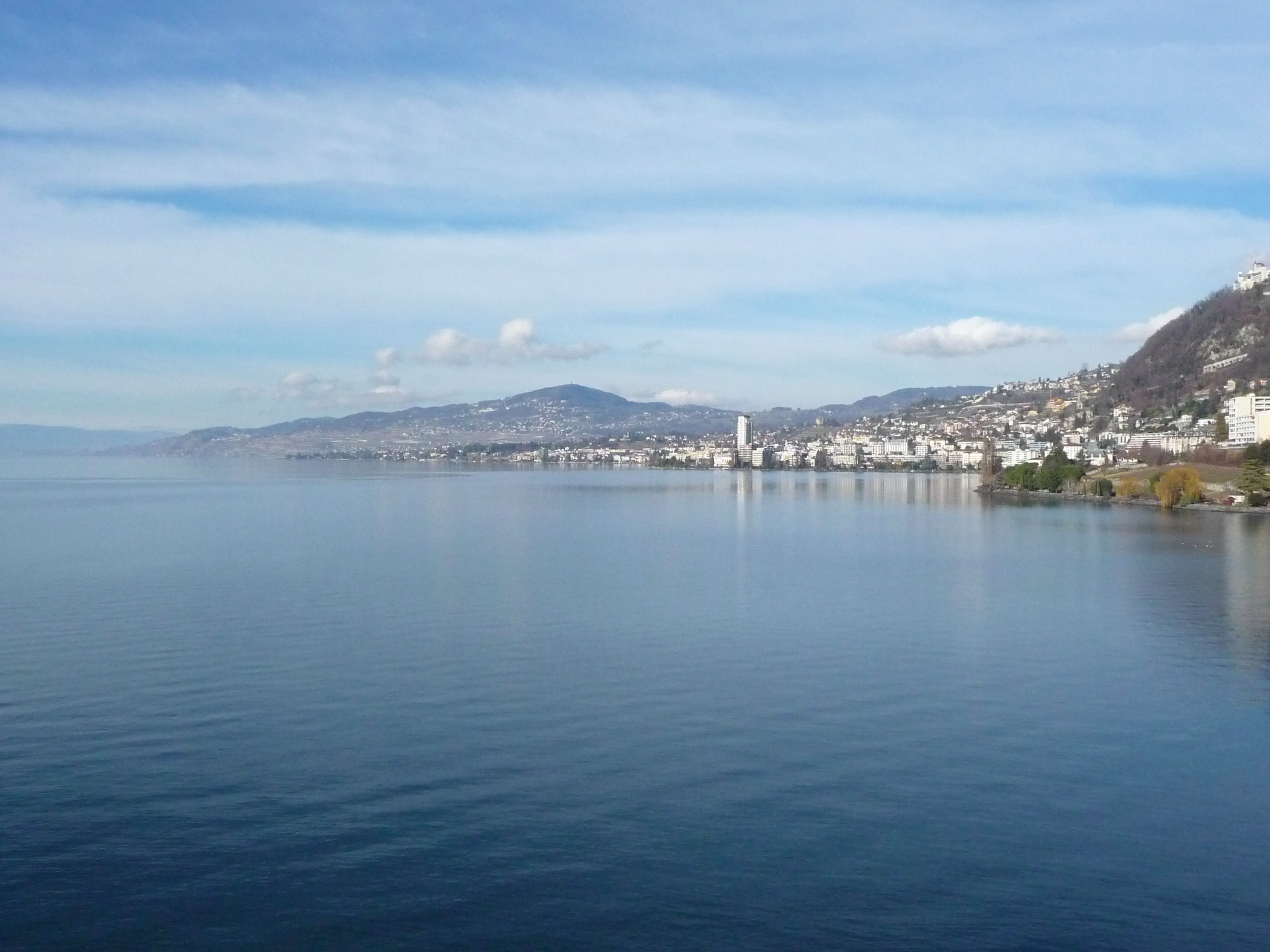
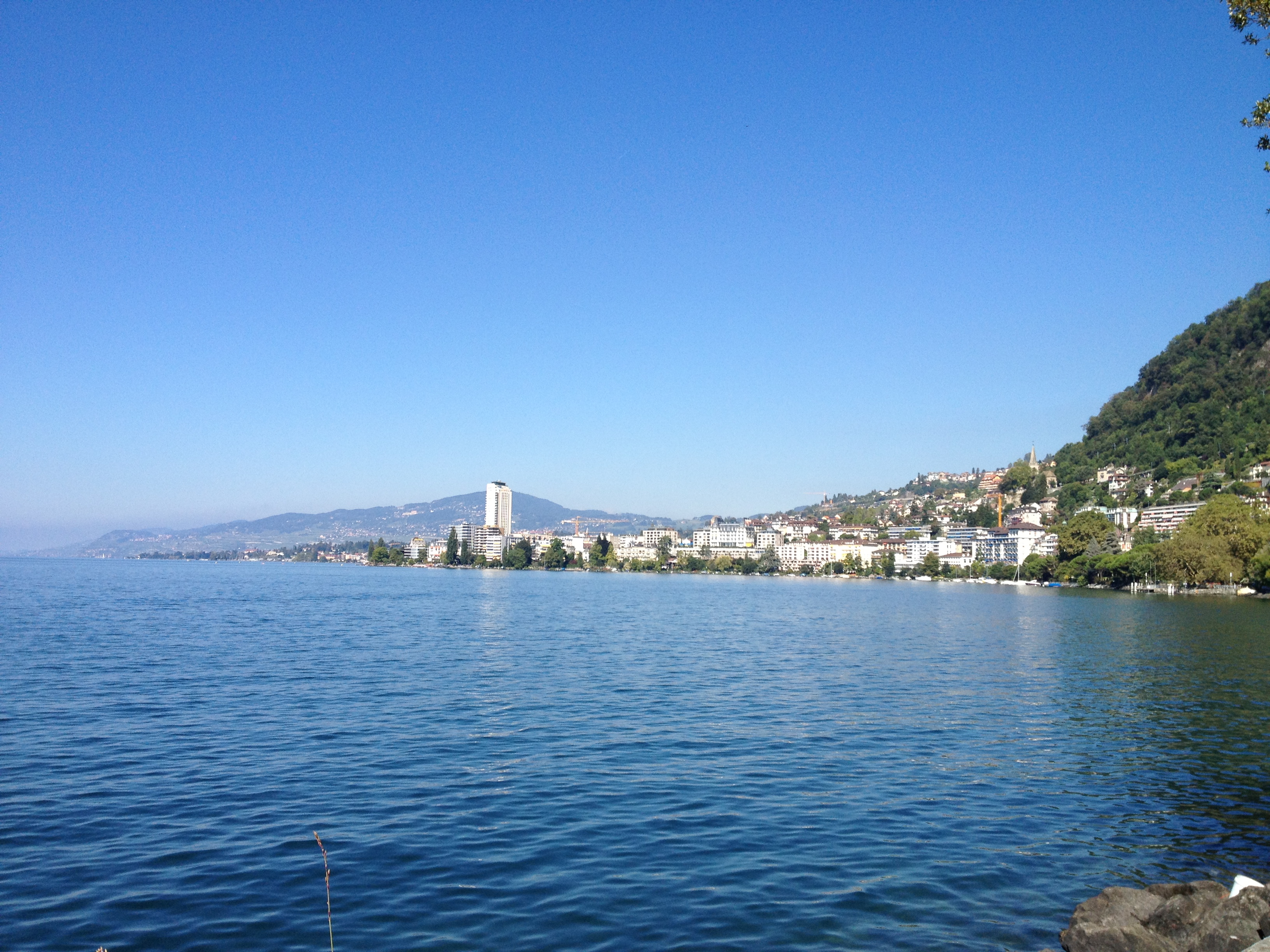
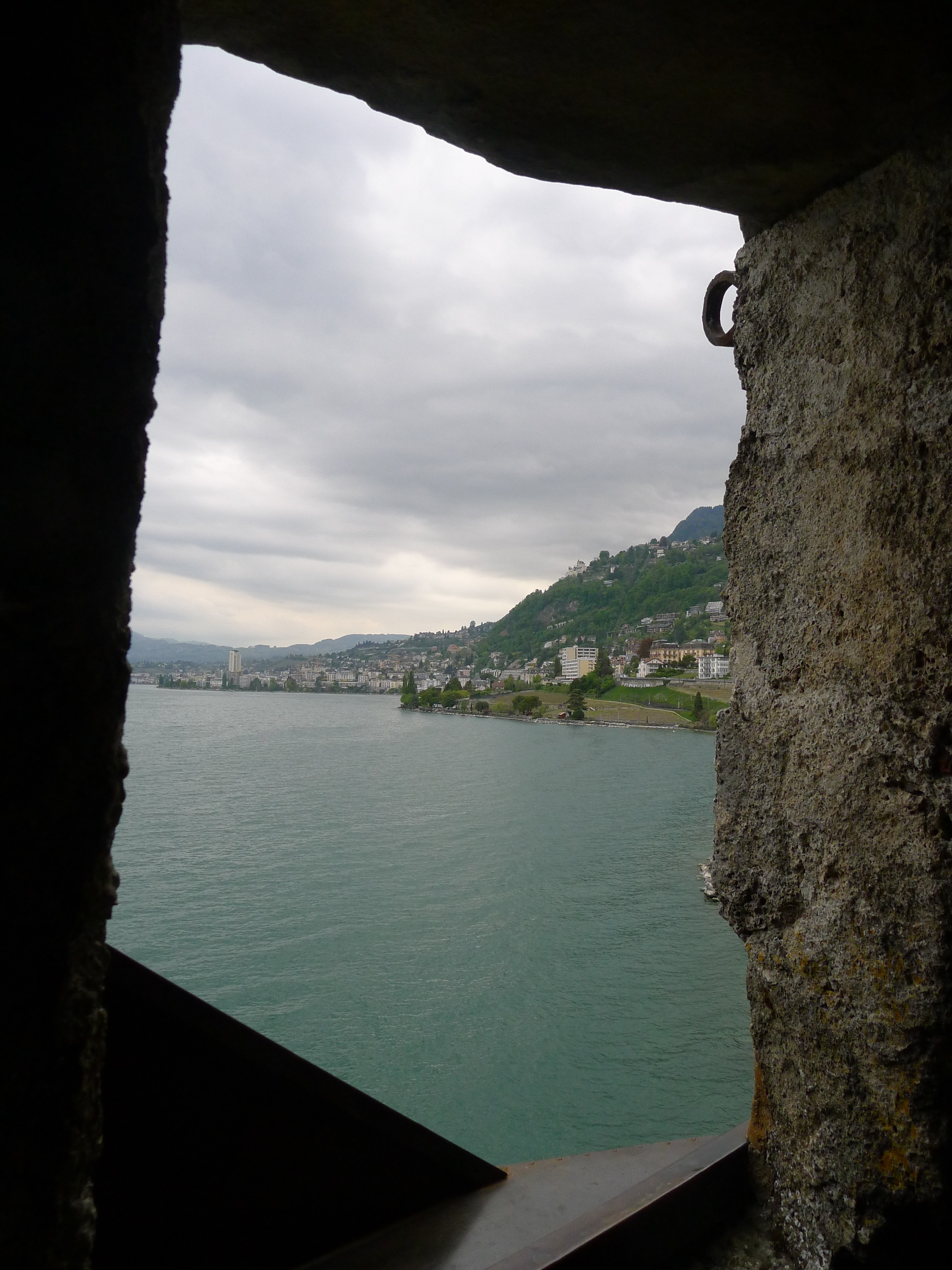
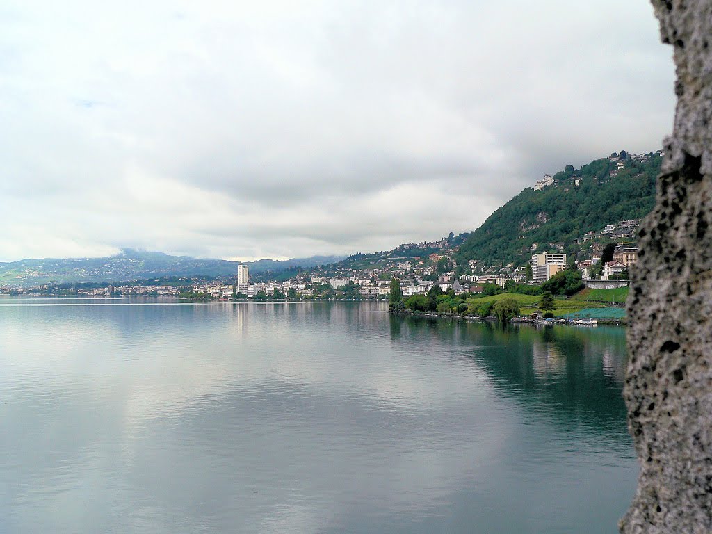
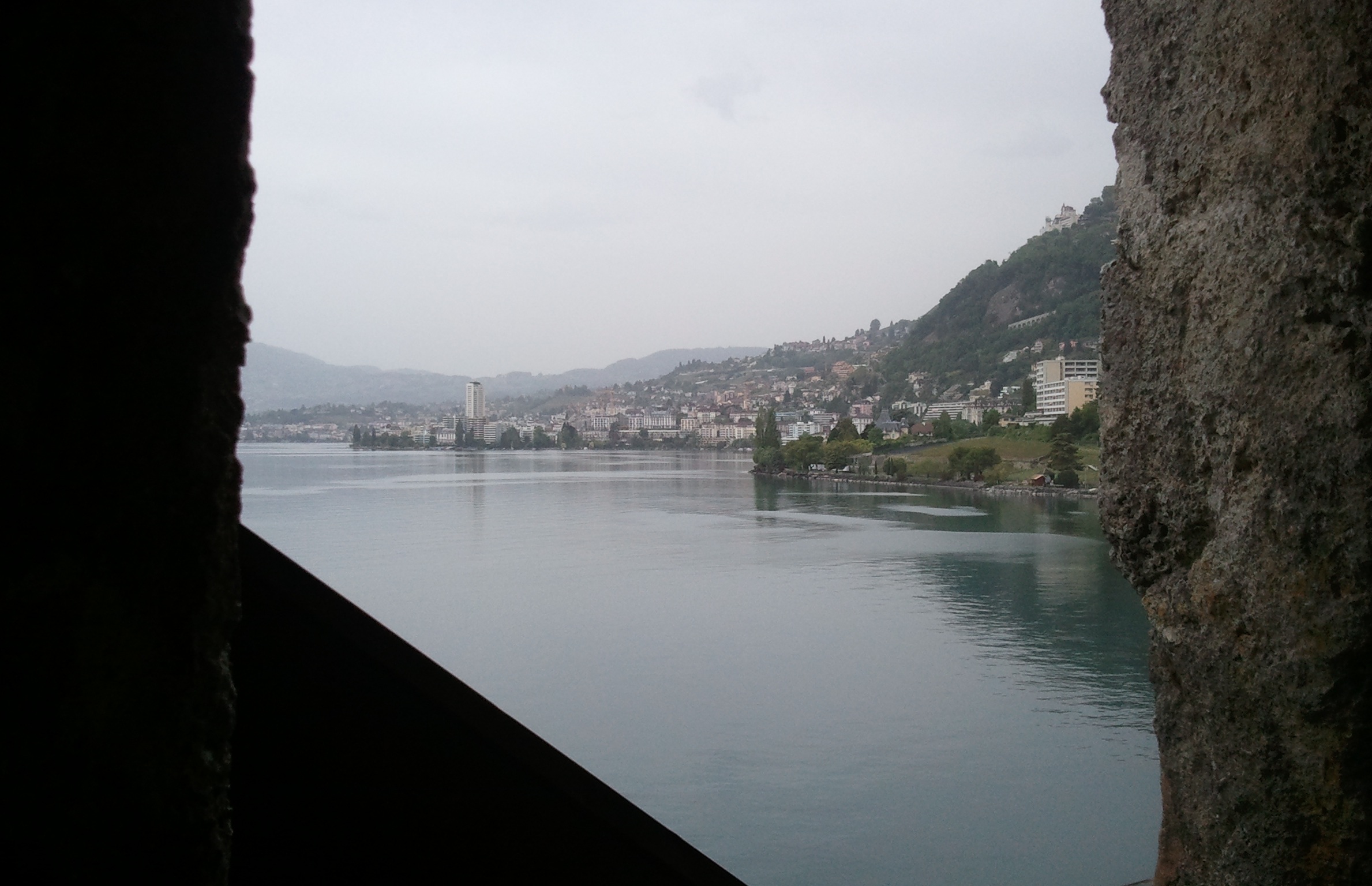
This week’s VFYW contest picture was taken from a window in the stunning Château de Chillon on Lake Geneva in Veytaux, Switzerland. I visited it in February 2010 and took a similar picture from (probably) a different window looking toward the city of Montreux:
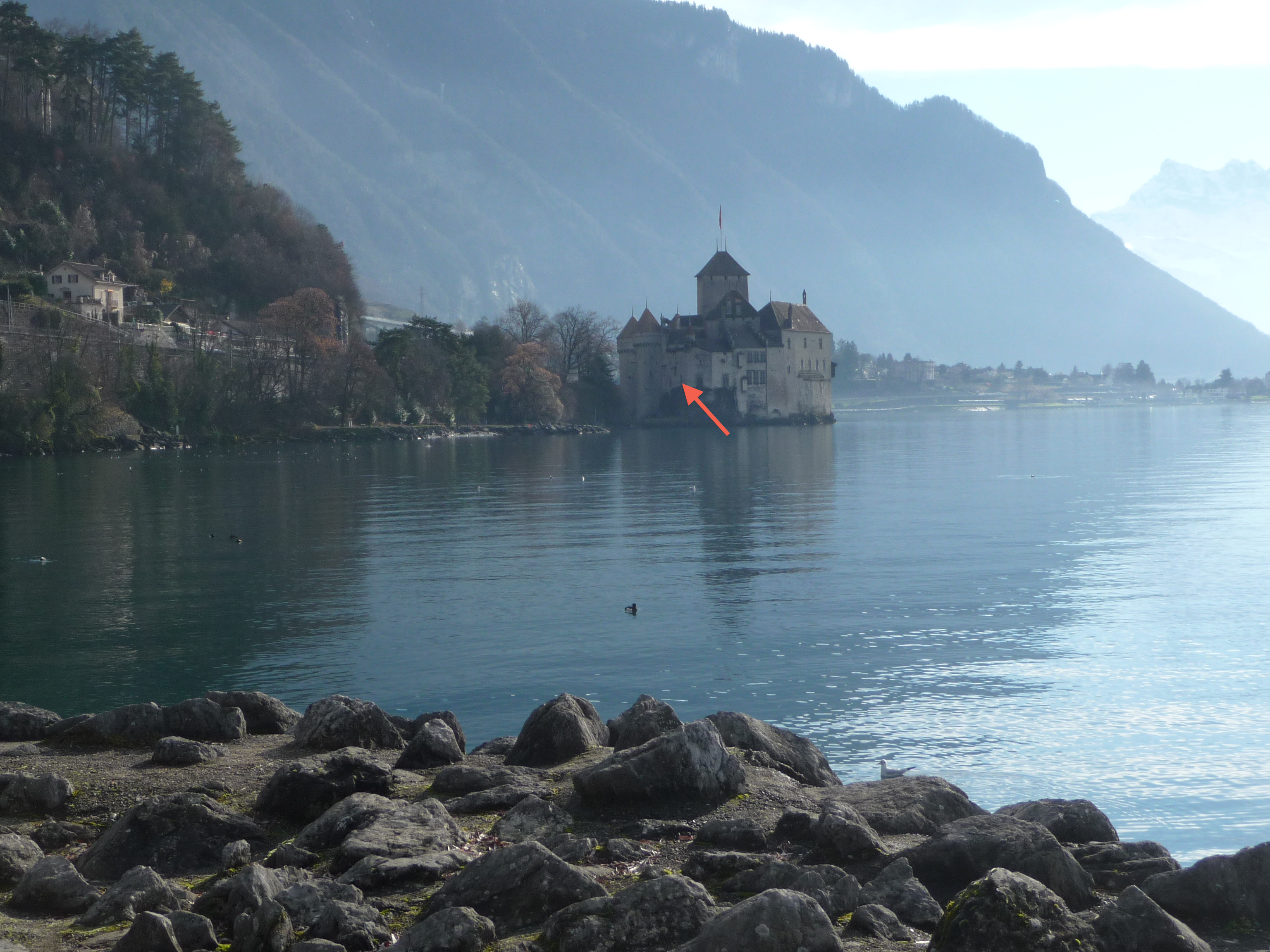
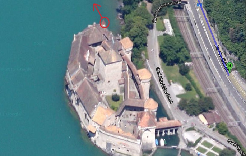
And here’s a photo I took from the shore in the contest picture, looking back at the Château, with my best guess on the window:
Indeed, many readers were delighted to revisit the Alps this week:
The photo is taken from the Chateau de Chillon in Veytaux Switzerland, looking North along the shore of Lac Leman toward Monteux. I haven’t been there since the early spring of 1983, but I recognized it instantly. I remember heading for Geneva by train from Rome. I was a few months shy of 19. It was a gorgeous day, with a full view of the Alps coming through the Rhone Valley. I happened to be out in the passageway gazing at the Lake and the mountains beyond when we passed the Chateau on the way into Montreux. I grabbed my backpack and hopped off the train there, and walked back to Veytaux, where the castle is located. I was very into castles in those days, but had never heard of Chillon. So I just happened upon one of the most beautiful in the world, and on a day that did it full justice. What a great day.
An impressive visual entry:
Another reader:
Wow. Just saw the VFYW picture for this week, and I knew instantly where it was taken. Just offshore on Lac Leman in the Canton of Vaud, Switzerland. My family relocated to Lausanne, Switzerland, for a few years back in the 1980s and my parents brought every visitor, every out-of-town guest (and of course, us kids) to experience the Chateau. How many times did I look out a window like the one in the picture and try to imagine what it was really like back in the day! I was around 12 years old back then, and seeing that photo was kind of thrilling. Thanks.
But this reader trumps everyone:
I didn’t see this weekend’s contest until Sunday evening, having just come back from an afternoon’s walk to Chateau-de-Chillon! Obviously the view is from the top of the chateau looking towards Montreux.
So that’s a hat trick of on-the-spot windows for me. First was a bit further down Lac Leman at Lausanne in VFYW #8. Second was the amazing coincidence of Double Bay in Sydney in VFYW #33. And then today here is a photo of me (on the right) at the Chateau and the boat going past:
It is a great coincidence but to be honest it is now feeling a bit like stalking.
Another:
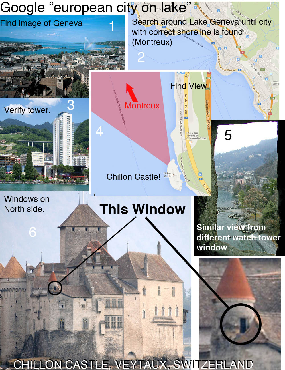
Really fun one this week. I took a tour of ancient and medieval architecture of the Mediterranean and southern Europe before finding the spot. The puzzle was solved with my favorite image search yet: “switzerland lonely highrise,” which yielded this picture as the 4th result:
Another explains the unsightly tower seen above:
The town you can see a kilometer or two away is Montreux, Switzerland. Can I give a shout-out to the Tour D’ivoire, that godawful 25-story apartment block in the middle of downtown Montreux? The town would look a lot prettier without it, but it was the only easily identifiable landmark. Without it I would still be scrolling randomly through thousands of pictures of alpine lake-towns.
But Montreax has a musical history as well:
A couple of nights ago I watched a biography on Queen, and Montreax was where the band lived in tax exile from the insane tax rates of the late 1970s in the UK. With a 75% tax rate on high earners and a further 15% surcharge on investment income, can you blame them?
I grew up in the ’80s and Freddie Mercury was the first person that I knew who died of AIDS. Up to that point in my life, AIDS was a disease that affected other people – people who I did not know. Actors from my parents generation like Rock Hudson or people in faraway places. I was 18, gay, and deeply in the closet when Freddie died. His death scared the hell out of me. To this day, I still can’t listen to “These Days Are The Days Are Our Lives” without crying:
The video is the last time Freddie Mercury appeared on camera and was visibly frail. It was released on the 5th of September in 1991 on Freddie’s 45th birthday. He passed away on the 24th of November, 1991.
I’m not going to go looking for the correct window. Somebody else can waste a beautiful Saturday afternoon doing that. But I do hope you will post a picture of the Freddie Mercury statue that is located in the town of Montreux and overlooks the Lake Geneva:
Another was also inspired by Queen:
I have read VFYW submissions regularly for the past two years, but this is the first time that I felt a personal connection to the location of the contest photo. In the fall of 2011 I rode a bike along Lake Geneva from Lausanne to the Chateau de Chillon, in Veytaux, Switzerland. I stopped to take the photo of the castle, and my guess of which window the contest photo was taken from is circled:
I made the bike ride on September 3, 2011, which happened to be during the annual Montreux Freddie Mercury Festival. Once I realized what was happening, I stopped my bike to dance to the sounds of the tribute bands. It was a beautiful and surreal bike ride along the lake, and the combination of the scenery and festival made it one of the most memorable days of my life. Now when I think of the Chateau de Chillon, the first Queen that pops into my head is not the one that is normally associated with a 12th century castle.
Another rock fan:
What interested me is the giant statue of Freddy Mercury in Montreux, which is just a bad-ass thing to learn exists. I knew of Mercury’s interesting parentage and upbringing, but didn’t realize that he settled in Montreux (home of the famous jazz festival) and recorded the last Queen record near the end of his life in a studio he bought.
Also of rock & roll history interest is the Montreux casino (the big high-rise sits in front of it), which was a popular venue for the jazz festival and in 1971 burned to the ground when some jackass sent up a flare during a Frank Zappa concert. The event was the basis for the Deep Purple song “Smoke on the Water”, a classic rock song best known (and well-parodied by Kids in the Hall) as being one of the first (read: easiest) songs any kid for several decades learned to play when they picked up a guitar.
And the Chateau has a cultural heritage as well:
While I would love to call myself a first-time player, that would be discounting the many times I looked at the VFYW contest and after 5 minutes sighed in despair over the so much more gifted players. But the last couple of days I just happened to be researching movies that concern the summer in 1816 when while staying with her then-boyfriend Percy Shelley and Lord Byron at the Villa Diodati near Lake Geneva, Mary Shelley conceived of the story of Frankenstein.
So I look at the contest this week and go: that’s definitely Old Europe. And it sure looks like a lake. Could it be … ? So I take a drive with Google maps around the perimeter of lake Geneva and happen quite quickly upon some of those buildings and sights in the background. Which leaves me with some triangulation to do in order to determine the window.
How could it have been anywhere else? The picture of course was taken from a window of the Castle Chillon, which inspired Lord Byron’s poem “The Prisoner of Chillon”. I yield to better players to determine exactly which one. I will say that at first it looked like one of the arrow slits near the water surface on the north side. But then there was this triangular black shape just outside the window… maybe a rooftop covered in shadow? So I’ll attach a guess:
What a rush finally recognizing a view. To quote Geena Davis in Thelma and Louise: Now I know what all the fuzz is about!
Another on the castle:
It was made famous to English speakers by George Gordon, Lord Byron, who wrote “The Prisoner of Chillon”. There was a time when people committed huge chunks of poetry to memory. My 96-year-old mother just recited the following verse to me:
Lac Leman lies by Chillon’s walls:
A thousand feet in depth below
Its massy waters meet and flow;Thanks for the “views” – and the memories.
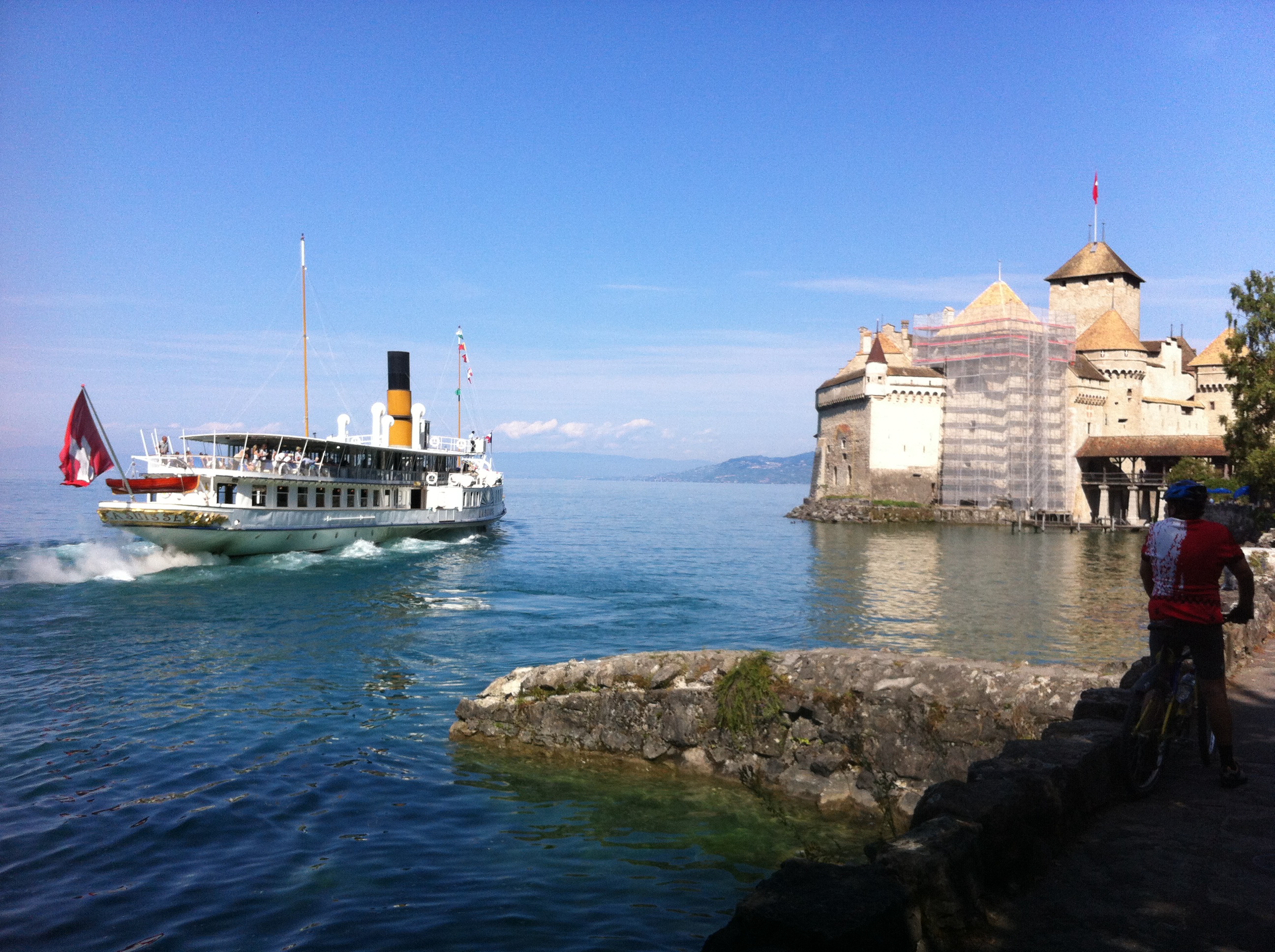
Another shares their pic from the same exact window:
My wife and I were there in April and she took a photo from the same window. The window is indicated by an arrow in the attached photo. Chillon Castle dates from the 12th Century. It was built to control movement between the north and south of Europe through the upper Rhone valley. The prison in a lower level of the castle was made famous by Lord Byron in his poem “The Prisonier of Chillon”. Byron left his mark on a pilar in the prison.
Another finds the inside view:
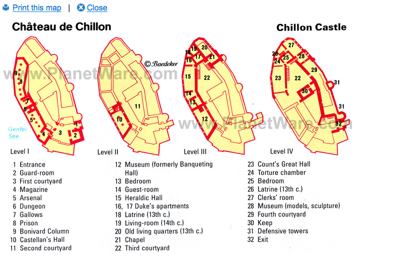
The online floor plan of the museum shows no indication that this part of the structure is publicly accessible, but the window would be above #27 “Clerks’ Room”:
Another used this video tour. And here’s Chini:
Great, so I’ve got the flu in June and some Dish viewer’s running around the Alps touring real life Disney castles. Not fair! At least there was some fun to be had in finding the room where the picture was shot. Figuring out the layout of hotels is one thing; doing the same for a 900-year-old castle is a whole different ball of wax.
Speaking of balls:
And this week’s collage of guesses:
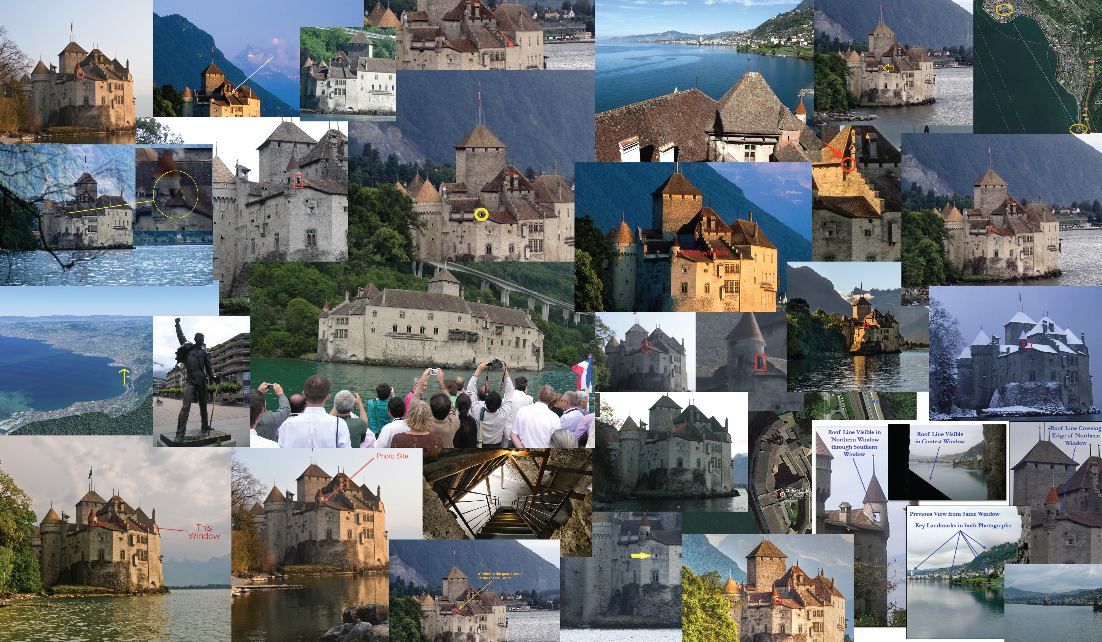
The winning entry this week comes from a husband-and-wife team that has now correctly guessed nine contests in a row:
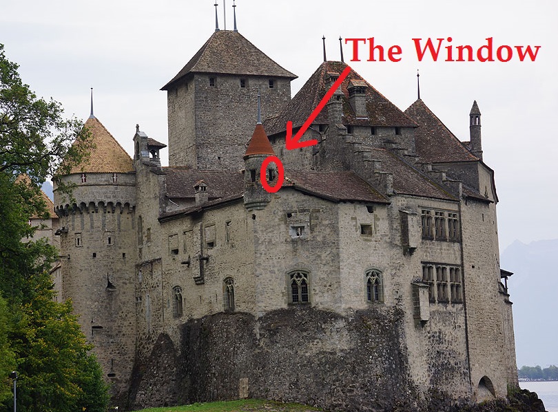
Our guess is that the contest photograph was taken from the Château de Chillon, a castle in Veytaux, Switzerland. The castle is located on a small island in Lake Geneva, and its address is listed on its website as Avenue de Chillon 21, CH – 1820 Veytaux. (Yes, these days even medieval castles have websites.) The photograph was taken facing north-northwest. We are guessing it was shot from the turret window circled in the photograph below:
Normally we would specify which floor, but given the history of the castle (a hundred independent buildings gradually connected over centuries of construction) we’re not sure the ordinary logic holds. (Is a turret a “floor”? Do you count the dungeon?)
Our first impression of the contest photo was that the placid waters and the nature of the shoreline suggested we were looking at a lakefront. The rough surface of the window “frame” suggested an older stone structure such as a castle. Combined with look of the foliage and presence of mountains close to the lakeshore we thought of the Italian Lake District (Lake Garda, Como, etc.) or of Lake Geneva in Switzerland.
Going on Google Earth we searched the Italian Lake District, hoping in particular that we would find that the contest photograph was taken from George Clooney’s island castle in Lake Como. (Perhaps George is a Dishhead). Sadly, the terrain was not a match. Also, the buildings in the contest photograph appeared too modern to fit what we were seeing in that part of Italy.
Moving on to Plan B, Lake Geneva, we quickly found the Château de Chillon, and from there the nearby city of Montreux which has a white high-rise structure matching the one that features prominently in the contest photo. Locating the below photograph taken from the Château de Chillon which is nearly identical to the contest photo clinched our choice.
An impressive guess from an impressive pair of players. From the view’s submitter:
I am very excited to see my picture in this week’s contest. I am travelling around southern Europe for four weeks and Switzerland was my first stop. This picture was taken on a cloudy but beautiful day, looking north-west out of the north-most tower in the Chateau De Chillon, onto Montreux city on the shores of Lake Geneva.
This is technically not one of the four watch towers but the view from the north-most watch tower would probably look the same. The Chateau is an island castle on Lake Geneva and was made famous by Lord Byron’s poem “The Prisoner of Chillon”. It is located a couple of kilometers from Montreux, famous for its Jazz festival and other music links. The song “Smoke on the water” by Deep Purple refers to a fire in the Montreux casino.
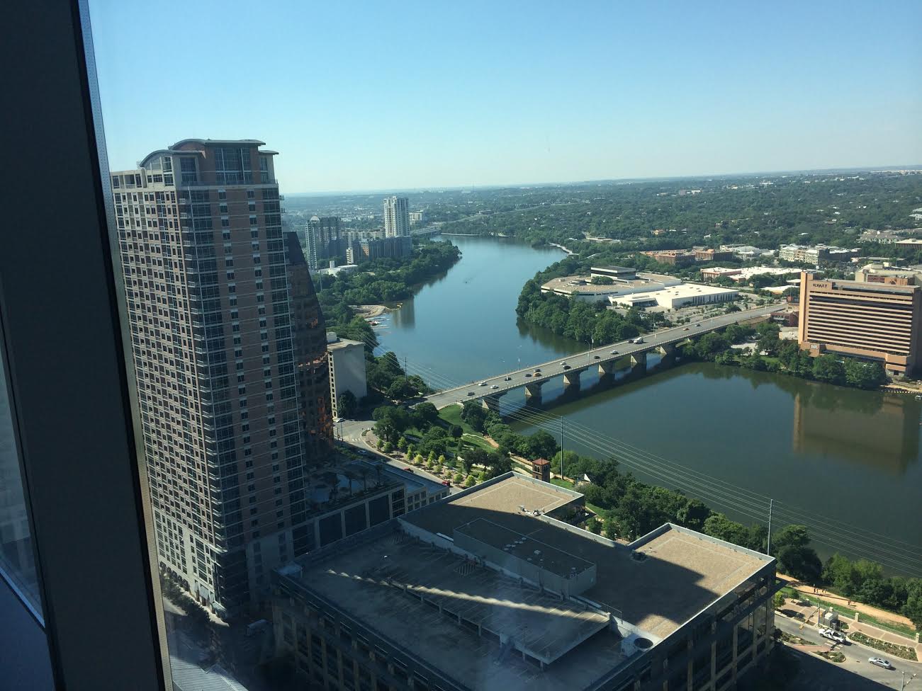
Austin, Texas, 10 am

San Francisco, California, 6 am
You have until noon on Tuesday to guess it. City and/or state first, then country. Please put the location in the subject heading, along with any description within the email. If no one guesses the exact location, proximity counts. Be sure to email entries to contest@andrewsullivan.com. Winner gets a free The View From Your Window book or two free gift subscriptions to the Dish. Have at it.
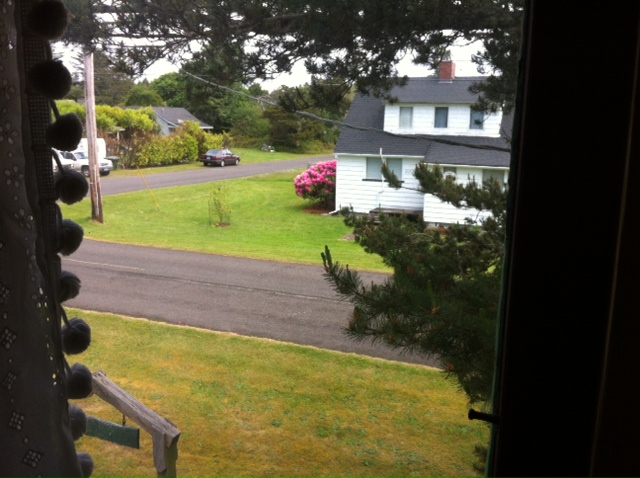
Ocean Park, Washington, 12 pm

Yangon, Burma, 6.34 pm
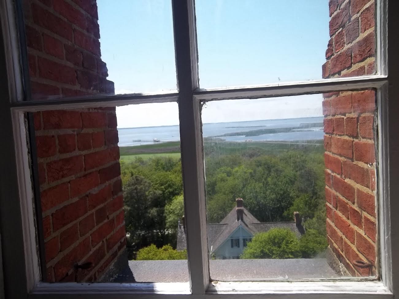
Corolla, North Carolina, 2.37 pm
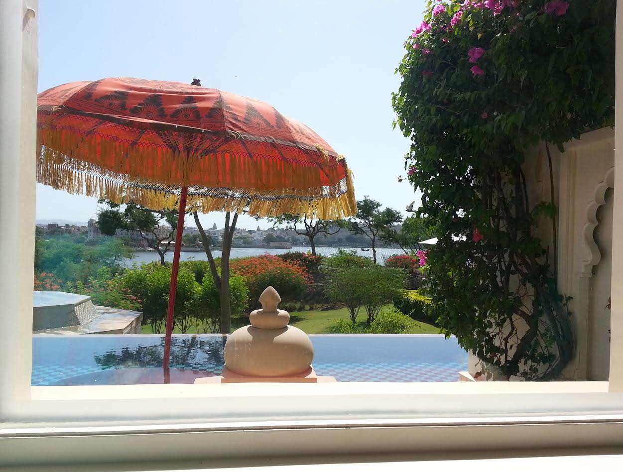
Udaipur, India, 12 pm

A reader writes:
This looks to me like a view of the Alexandra Bridge that connects Ottawa, Ontario with Gatineau (Hull), Québec, taken on the Gatineau side (call it 2km NE of Parliament Hill). I used to ride my bike along the Ottawa River, on both the Ontario and Québec sides, and this looks familiar, if not 100% right. But I can’t name the building.
Another totally e-mails it in:
The blue banner on the light post is clearly shaped like Vietnam, so (equally clearly) the picture must be from Hanoi.
Another:
I’m pretty sure this is taken from the eastern bank of the Schuylkill River in Philadelphia. I feel like I’ve walked on that bridge and that is the fairly new bike path they’ve built. This is my first time entering. I do love the contest. It would be baller to get it right the first time!
Another rookie:
Very first attempt! My guess is Louisville, in the park along the Ohio River, where there is a memorial to Abraham Lincoln. The bridge is a former railway bridge to Indiana, and is now used as a bike or running bridge.
Another stays in the South:
Probably not right, but it looks so damn much like Brown’s Island Park in Richmond, VA. I’ve run on the James River North Bank Trail that ends at that park. The bridge design and river look so insanely like Richmond, but the picture’s just slightly off. Who knows, maybe I’m insanely wrong.
Or wanting to be:
Augusta, Georgia. I hope I’m wrong.
Several others were wrong about the man from Hope:
Clinton Presidential Museum, Little Rock, Arkansas. I knew it the minute I saw the railroad trestle. The museum is nestled just on the edge of Little Rock in one of the prettiest settings. I visited it during an International Master Gardener Conference a few years ago.
Little Rock was the most popular incorrect guess this week. The most popular correct guess attracted 117 entries – a whopping 84% of the total submitted. One of those correct readers:
First impression was: Upper Midwest due to the rail bridge, somewhere in Minnesota or Iowa on the Mississippi. Then I realized way too flat for Saint Paul or Minneapolis and the
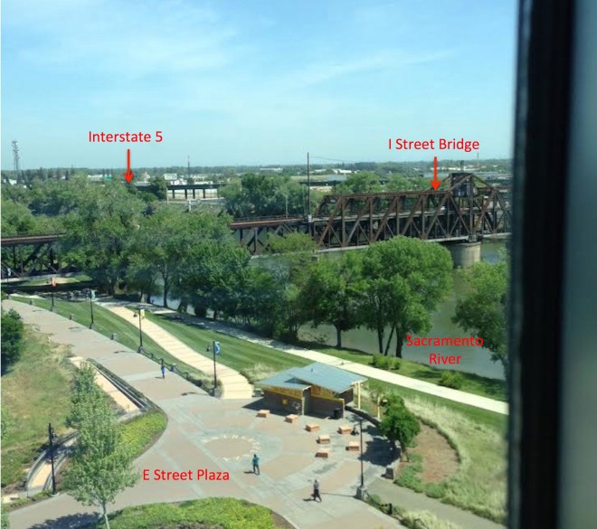
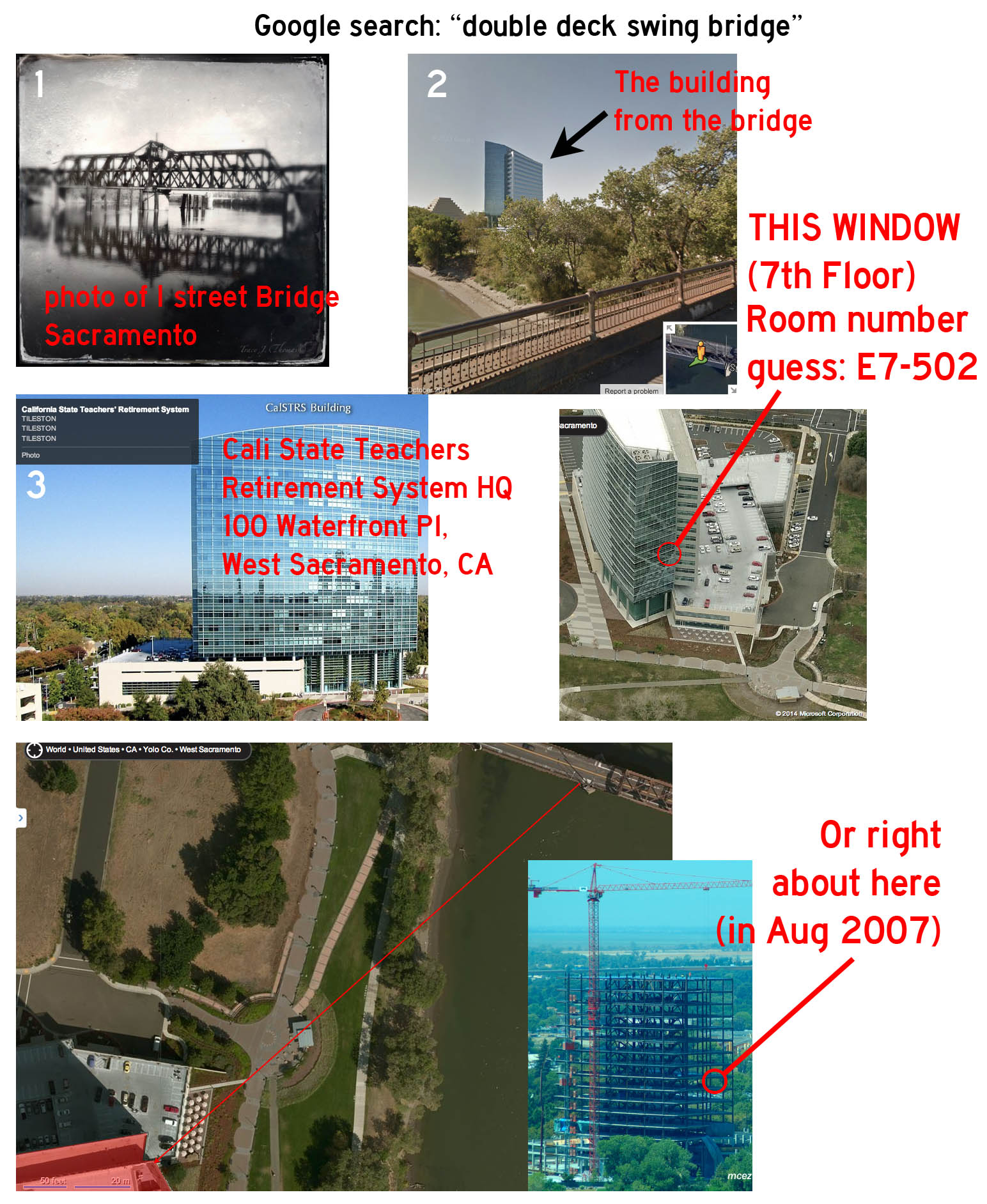
rest of the Mississippi valley. Usually my gut is right on these things, but a bit of searching for a double-decker bridge brings one to West Sacramento, California.
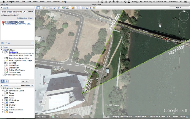
You’ll have lots of people who’ll get the location, but Google Streetview only has a 2007 photo of the building under construction or a more recent bad angle shot from the street (damn you Google for not having the foresight to send a rogue self driving car to that spot). Nonetheless I’ve attached my guess on the right window. The obsessive Dishheads will spend hours on the angles, cosines, etc, and a few may resort to psychotropics, peak beard, or a bear with a divining rod. Lacking access to any of these I’ll go with with the 6th floor, room 659 and the fat red X. I await being corrected by Doug Chini. But the city location was easy: if a slacker like me can find it in 15 minutes, the heat map of West Sacramento will show one huge blue dot.
He’s sure right about that:
Another reader squeals:
IGotOneIGotOneIGotOne! As all the train-and-bridge spotters have figured out, a Google search of “railroad swing bridge double” served up the “I” Street bridge in Sacramento lickety quick, and maps revealed the 100 Waterfront Place building. I’m sure the pros have already sussed out the latitude, longitude, elevation, time of day, temperature, paint color, bar menu, beagle population and average beard length of the neighborhood, and then taken the rest of the afternoon off for beer and volleyball. They can have it; i’ll just bask in the satisfaction knowing I beat one of these things.
An elaborate visual entry:
Marriage finally pays off for this contestant:
My lovely wife of nearly 40 years is pretty tolerant of me, especially when I call her over to the computer, point at a VFYW picture, and ask where she thinks it is. Usually she just shrugs, says “no idea”, and heads off to more important things. To my amazement, this week she looked at the picture for about 5 seconds and said “I Street Bridge”, not as a question but as a statement. She is a Sacramento native, so I guess I should not be too surprised.
Another goes into detail about one of the central clues:
The first thing I did was search for images of double-decker railroad bridges. The search led within a few minutes to this page showing the I Street Bridge on the site bridgehunter.com. It describes the bridge in detail and includes a photo gallery, map links and street views. (Bridgehunter.com, by the way, looks like it’s going to be an invaluable resource in future window contests involving American bridges.)
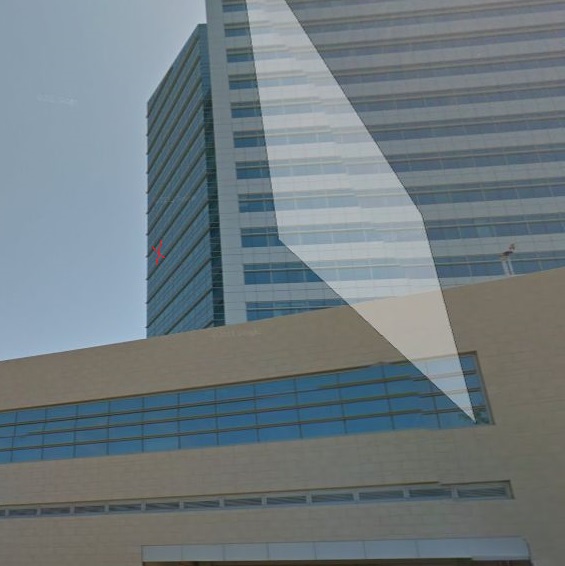
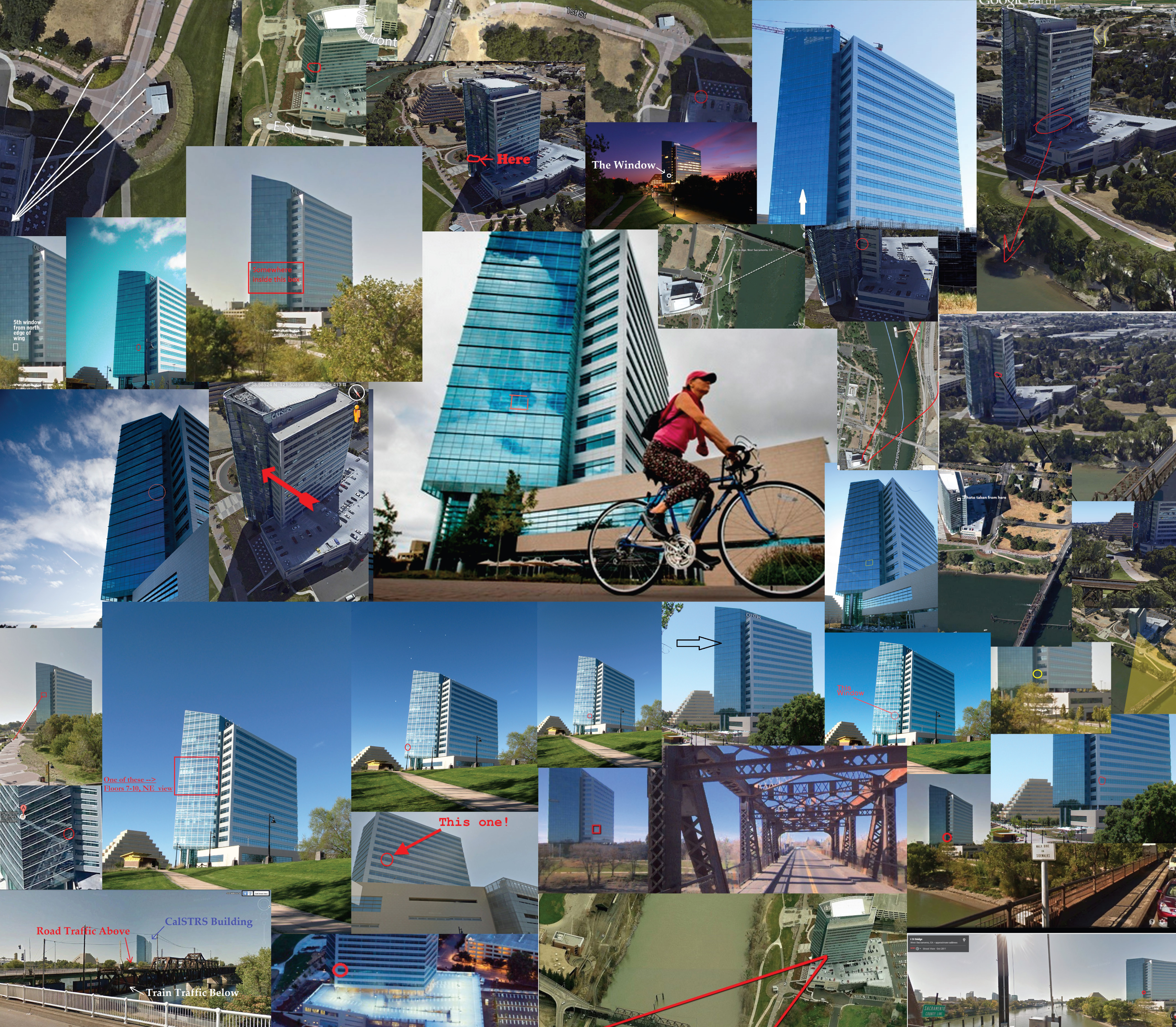
From there, identifying the building the window is in was as easy as falling off a piece of cake: California State Teachers’ Retirement System, at 100 Waterfront Pl in West Sacramento, California. This modified Google Earth view shows the angle of the photograph indicating roughly where the window is.
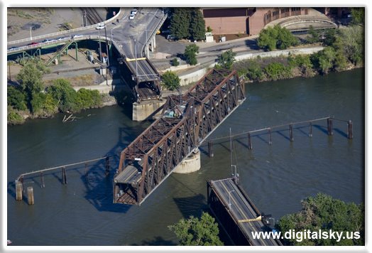
The I Street Bridge, by the way, was completed in 1911; its two decks accommodate rail and highway traffic. It’s of a type known as a swing bridge, which means that the center span of the bridge pivots to allow boats to pass, as seen here:
Several readers flagged this blog post about the I Street Bridge written by California bridge engineer Mark Yashinsky:
A swing railroad bridge has stood at this site since 1858. The current double-deck bridge was built in 1911. Note the round pivot pier supporting the swing span. This bridge is 840 ft long with a 340 ft long swing span. A 34 ft tall boat can pass under it at low tide. Otherwise, the captain must signal to the bridge operator to get through. Boaters need to check with the US Coast Guard when planning a trip to find out the bridge’s hours of operation. …
This is one of the largest center bearing swing bridges ever built. It weighs about 6800 kips. At the turn of the 19th century, such big swing bridges had rim bearings with rollers along the perimeter. When this large bridge was successfully built and operated with a center bearing, no one wanted to go through the trouble of fabricating the conical rollers that supported a rim bearing swing bridge and they were no longer built.
Another reader found an additional bridge resource:
Once more the VFYW contest has been a learning opportunity. I came to realize after some hours of poking about that without a base in bridge terminology, finding this thing wasn’t going to be a snap. I tried every combination I could think of involving steel bridge, railroad-bridge, double-decker, riverwalk, river park. Eventually a likely-but-too-tiny-to-tell icon showed up, and that led me to historicbridges.org, which would have been great if only I’d already known where in the world I thought this bridge was to search their database efficiently. But historicbridges.org introduced me to the descriptors I needed: steel truss bridge, swing bridge. If only I’d known those terms to begin with! A search for “steel truss bridge” delivered the culprit about 200 images down in a few moments of skimming the Google images result, unmistakable (it’s amazing how subtly distinguishable steel truss bridges are one from another, though).
Then I realized that I had ridden Amtrak over that very bridge on my way home to the Bay Area from Manhattan just two months ago.
Another skipped the bridge for a different clue:
Three in a row for me, and a chance to avenge a past near-miss! Early last year I had narrowed a view to Sacramento on little more than hunches, a red curb, and fertile farmland near a sizeable city. But having no luck scanning Google Earth or proof I even had the right city, I called off the search. In my personal tally it wears an asterisk, a badge of shame on my record.
But goddammit, this week we’re straight-up comin’ atcha from the neighboring town of West Sacramento, CA. Nothing fancy this week – didn’t even flex my bridgespotting muscles. Just stared at the letters on the pavement and wrote out twelve blank spaces on a sheet of paper, Wheel of Fortune-style. Funny thing, I was listening to a recording of Bruce Springsteen’s recent Charlotte show when I finally made out what it read: E Street Plaza. A few of those about, but not hard to whittle down.
The pic is from the California Teachers Retirement System Building, seventhish floor. No doubt shot from the employee break room, where somebody recently ate Alice’s sandwich even though she clearly wrote her name on it. Turkey and Swiss with avocado because it’s California.
More word-gaming:
I started with the letters on the walkway. I could tell there are 12 letters, but they were very difficult to make out. Did you know that ‘Extravaganza’ is the only english word I could find with 12 letters and ends with za?
Eventually I went with “streetplaza”, although I could not make out the first letter and had to go through the alphabet until I found a picture of a train trestle crossing a river. It is actually a train/automobile swing bridge – the I Street Bridge – that spans the Sacramento River and connects West Sacramento to Sacramento. One can see Interstate 5 in the background. Based on the shadows the picture was taken in the late morning.
This reader had to step back:
The giveaway clue is the yellow writing – which, in this case, was a “full Monet”: more easily decipherable from a distance, rather than zooming in. I got the “STREET PLAZA” pretty quickly, but what was that first character? It had to be a letter – so my first instinct was to go to DC, but the lack of East Coast buildup suggested otherwise.
I started Google Mapping “[letter] STREET PLAZA”, and discovered that several towns in California are named by single letters – San Diego, Modesto, Merced – and checking for cities with rivers, and especially railroad bridges over them, Sacramento’s E Street Plaza was quickly identifiable!
Another method focused on the economic evidence:
I was pretty certain this was somewhere in the Midwest, based on the flat terrain and old-style railroad trestle. After doing some unsuccessful image searching for railroad bridges in Iowa and Illinois, I started thinking about that riverfront walk. Not just any city can afford to re-do their riverfront like that (with the old-style lightposts, the landscaping and the facilities). This would need to be a medium-sized city with a decent economy to justify that kind of public spending on their riverfront. I started thinking of cities that were focusing on riverfront redevelopment, and as a native Californian, Sacramento popped into my head. Sure enough, that bridge came up at the top of my search, making this one of my fastest (and luckiest) VFYWs yet!
A former winner geeks out with some labels and factoids:
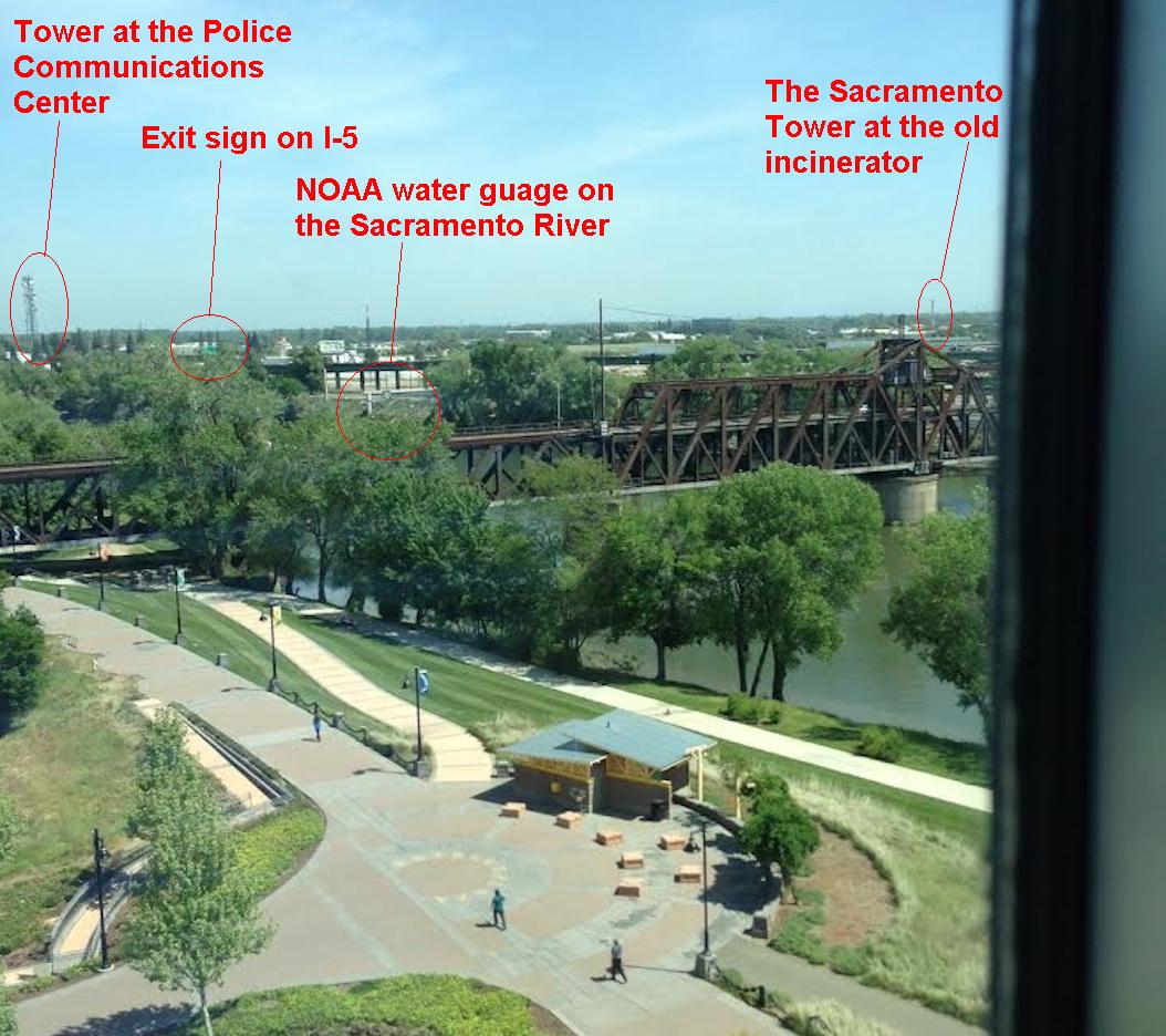
Several peculiar items can be seen in this week’s picture. First, the large tower on the left side of the picture is part of a police communications center. Watch one of the dishes being removed here. Second, in the middle of the picture there seems to be a pipe climbing out of the berm across the river. It turns out to be one of NOAA’s numerous water gauges that monitors river crests and flooding. Third, the faint smokestack on the right hand side of the picture is the Sacramento Tower. Built over a hundred years ago at the city incinerator, it was climbed for the first time by a local rock climber. He dedicated his ascent to the Americans taken hostage by Iran. Slightly odd and inefficient means of communication, but I’m sure the hostages appreciated the gesture.
Another provides some detail about the building:
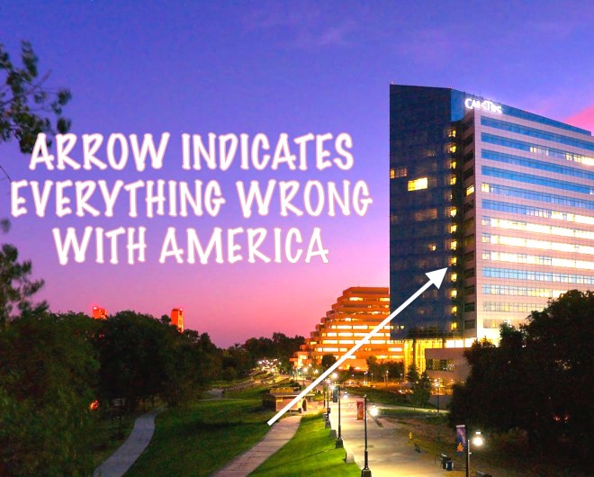
The photographer took this from CalSTRS, which according to Wikipedia “is the largest teacher’s retirement fund in the US”. It’s also the 8th largest public pension fund in the US. But it pails against the largest public fund in the state – CalPERS, which is #2 over all. CalPERS funding is also a bone of contention here in the state because of the unfunded contributions owed to it by many cities, counties and of course the state itself. Because of these unfunded liabilities, a couple of cities have filled for bankruptcy. Many more might follow.
Another casts a critical eye:
I don’t know much about economics and stuff, but even I know that the pension fund for California’s underpaid state teachers should not be headquartered in a 19-story, $266 million gorgeous monstrosity of glass and steel that was built for the purpose:
I’ll leave it to more qualified readers to say if this is capitalism run amok or socialism run amok, but it’s clearly one or the other, and quite possibly both. Seriously, CALSTRS. When you’re dwarfing the neighbors, and the neighbors happen to live in a ziggurat, that’s when you know you’ve overdone it.
Update from a reader who works at the building:
CalSTRS is the 2nd largest public pension fund in the US (by value of assets), not the 8th. CalPERS is the largest.
As far as socialism or capitalism running amok, I’ll just say that the workers here – a very dedicated lot, in my opinion as an outside consultant in organizational behavior – were in multiple and decrepit quarters before this building was built, and now they are in an environmentally healthy and sustainable building. And the only reason it dwarfs its neighbors is that it’s not in downtown Sacramento. Were it a bit more to the east, it would be dwarfed by a bunch of … wait for it … banks.
Finally, the view was taken from a conference room. The employee break room is in the middle of the floor. Nobody here steals anyone else’s sandwich.
On to the winner selection. The photo was taken from the fifth floor, but as is often the case, many readers wrote that their choice was the fifth floor but then circled a window on another floor. Most of these guesses started with the exterior window and then attempted to discern the floor number incorrectly. The following reader found a useful link for better understanding the layout of the building and which floor is which:
The CALSTRS office was finished in 2007 and was constructed to have low emissions and energy-use, enough so that some researchers at UC-Berkeley used it in a case study of environmentally-friendly building design.
The photo’s submitter said that the window “is in the northeast corner of the building on the 5th floor.” That makes the following reader the only one to guess it exactly right:
We’re looking out at the I Street Bridge. A quick image search for double-decker truss bridges got things narrowed down. I have no idea how the building offices are numbered, but I’m going to guess that this was taken from the 5th floor corner window closest to the river, facing the bridge.
Congrats to our winner on what is essentially an upset over many more experienced players. Among them:
Meanwhile, a former winner writes:
I dunno, 12th floor? Chini’s going to be like, “Well it looks like from the ground it’s about a 65.12265578456132° angle and it was taken about 10 minutes after the submitter, who’s a Scorpio, had a turkey sandwich and a Sprite at their desk, which is located approximately 52 feet from the elevator.” Seriously how has the CIA not contacted him yet? OR HAVE THEY?
Chini, who was actually off by two floors this week, marks his second anniversary with the contest:
The first view I ever found was posted on May 26, 2012 (VFYW #104), so it’s nice that we’ve returned to the state where this odd little journey began two years ago. Back then the contest seemed impossible, so I was disappointed when my entry for that week wasn’t published. But if at first you don’t succeed, try, try again …
Here’s that entry from his first week:
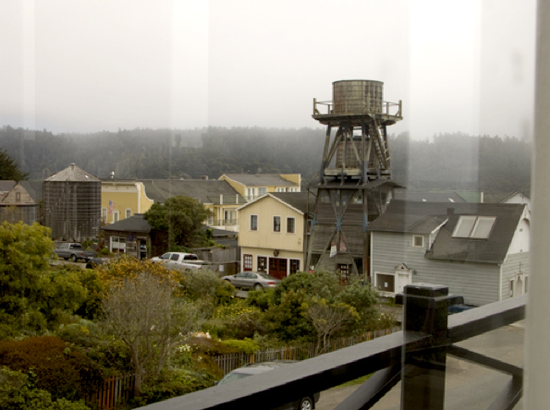
Years of reading the Dish and finally I got one! This week’s VFW shows a row of
buildings on Albion Street in Mendocino, California. The picture was taken from the southernmost of three side windows on the second floor of Odd Fellows Hall located at 10480 Kasten Street between Albion and Ukiah, or 39°18’20.01″N and 123°48’5.94″W. Originally built in 1878 as a meeting house, it’s used today primarily for local art exhibitions.
As for locating the reader’s building, the key was the water tower. A Google search for wooden water towers will bring up quite a few in Mendocino, including a view that is a near mirror image of the one your reader submitted. Much like last week’s contest, the buildings’ style threw me off a bit, as my first guess was Maine. (According to Wikipedia the town was settled by former New Englanders who brought their architecture with them, so much so that Mendocino was used as the setting of the fictional Cabot Cove, Maine in the TV show Murder, She Wrote).
Finding the particular window was a bit harder. The rearmost of the three second floor windows is blocked up, but the first two were prime candidates. To choose between them I focused on the reflections of the building’s thin front windows that are faintly visible in your reader’s picture. The rapid increase in their apparent width looking left to right meant that the shot was likely taken from the front-most side window; from a position near the middle side window, those reflections would appear much more uniform in width.
Finally, having never been there, but having been to the Marin Headlands down the coast, it sure seems like a nice place for a getaway weekend!