The View From Your Window Contest: Winner #188

vfyw_1-18

A reader writes:

Really?  I re-upped my subscription only to be mocked with this utterly ridiculous contest photo? It all looks vaguely Scandinavian, but that is not the point.  So all the stuff you write about on Sunday is obviously BS, since it is increasingly clear to me that you are beginning to taunt your readership.

I like that. I wish I had renewed for more that $25.00.

Another describes the scene:

Snow, low mountains, old industrial buildings in the foreground, turn of the 20th century-style housing in the background. This is a hardscrabble industrial town of the kind that you find throughout the northern reaches of Appalachia (just drive any part of I-81 for that experience). Pennsylvania alone has dozens of towns/cities that look like this, and I don’t have the patience to scour every single one on Google Earth. I’m going with my gut based on that mountain in the background: It reminds me of many a drive up to college past Binghamton, NY.

Another:

Early on in this contest I often spent an hour or more trying to determine the place. Then all the experts began their triangulation and GPS, etc. I could never keep up. I always try for the right continent and usually get that right. Starting this year, I thought I’d try for Hemisphere. That shouldn’t be too hard. This photo follows a pattern, hills in the background, a river, perhaps a lake, leafless trees and tin roofs. Another feature is the railroad track. A modern building – office-like looking. I was in Quebec last fall, so it’s as good a guess as any.

Right hemisphere. Another:

This looks like central Pennsylvania to me – but I don’t have Doug Chini‘s resolve, so I won’t be following every train track in the state looking for those bumpy roofs. Instead, I’ll just guess Wilkes-Barre, Pennsylvania – and I’ll look for my entry to appear well above the jump!

Another:

moca

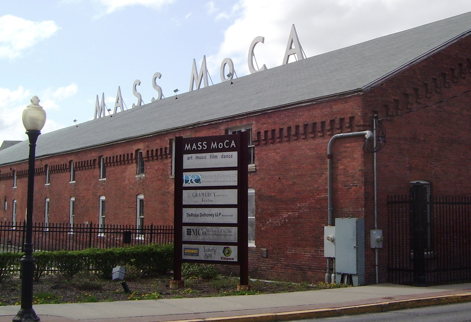
Well, I thought this was going to be two easy ones in a row.  It looks like a glamorous new lobby has been added to an old New-Englandish warehouse. Some kind of art/cultural destination near a railroad. Dia Beacon? No. MassMOCA? The warehouse has the same kind of scalloped edge! Has to be! Only I can’t for the life of me find this view on the map.  But I’ll submit North Adams, Mass, in case the same warehouse builder had other business in the area.

Another:

My initial reaction was that with visible dirt on the ground and less-than-impressive mountains in the background, we are looking through a window somewhere near Borat’s native Kazakhstan. And with the dimness and angle of the sunlight, I think we are somewhere near 49.0278° N latitude (give or take). Looking at cities around this latitude, I have choices of Lviv, Ukraine or Erdenet, Mongolia (which no one in the US has ever heard of). I’ll choose Erdenet. If this is right, I’d love to hear why anybody would ever be in Erdenet, Mongolia …

Another lands on the right continent:

This week’s picture lends new meaning to the word “grim.” You have never before used a photograph that portrays cheerlessness to this extent. It looks like a place which the world has left behind. My mind took itself immediately to Russia and the old Soviet Union, with the birch tree and unique narrow-gauge railway tracks (which helped lead to Hitler’s defeat) supporting my mental travel. Those several church steeples could be atop sanctuaries of the Russian Orthodox faith. With a higher resolution screen, it might be possible to determine what the parabolic shape in the middle background of the picture represents. It may be part of a stadium. The abundance of green, non-deciduous trees and the profile of old, worn down mountains have helped me convince myself that this is in the southern part of the Caucusus. Traveling to this place, sitting with a cup of coffee, and watching the place come to life on a sunny day in May, is an intriguing notion.

Another:

Gothenburg, Sweden? Because of the swooping-sided stadium barely visible in the background. I think that’s Ullevi stadium, but I can’t figure out the perspective and can’t spend any more time on it. I’d guess the photo is taken looking S-SE toward Ullevi stadium from around the port somewhere. Or not.

Another gets the right country:

The middle-distance houses look very German, especially the ones with pointy roofs. A run-down look, so probably east Germany. The hills look something like the tail-end of the Harz, so I’d go for Thale.

Another:

This is a hard one. The birch tree in the front and some vaguely German-looking houses far in the back. Also, Germany is kind of keen on the solar power these days, so the solar batteries on the roof of a warehouse are consistent, and their angle fits the general latitude of northern Germany. Beyond that – no clue. So I am going on a limb here and guess Bremen.

Another nails the right city:

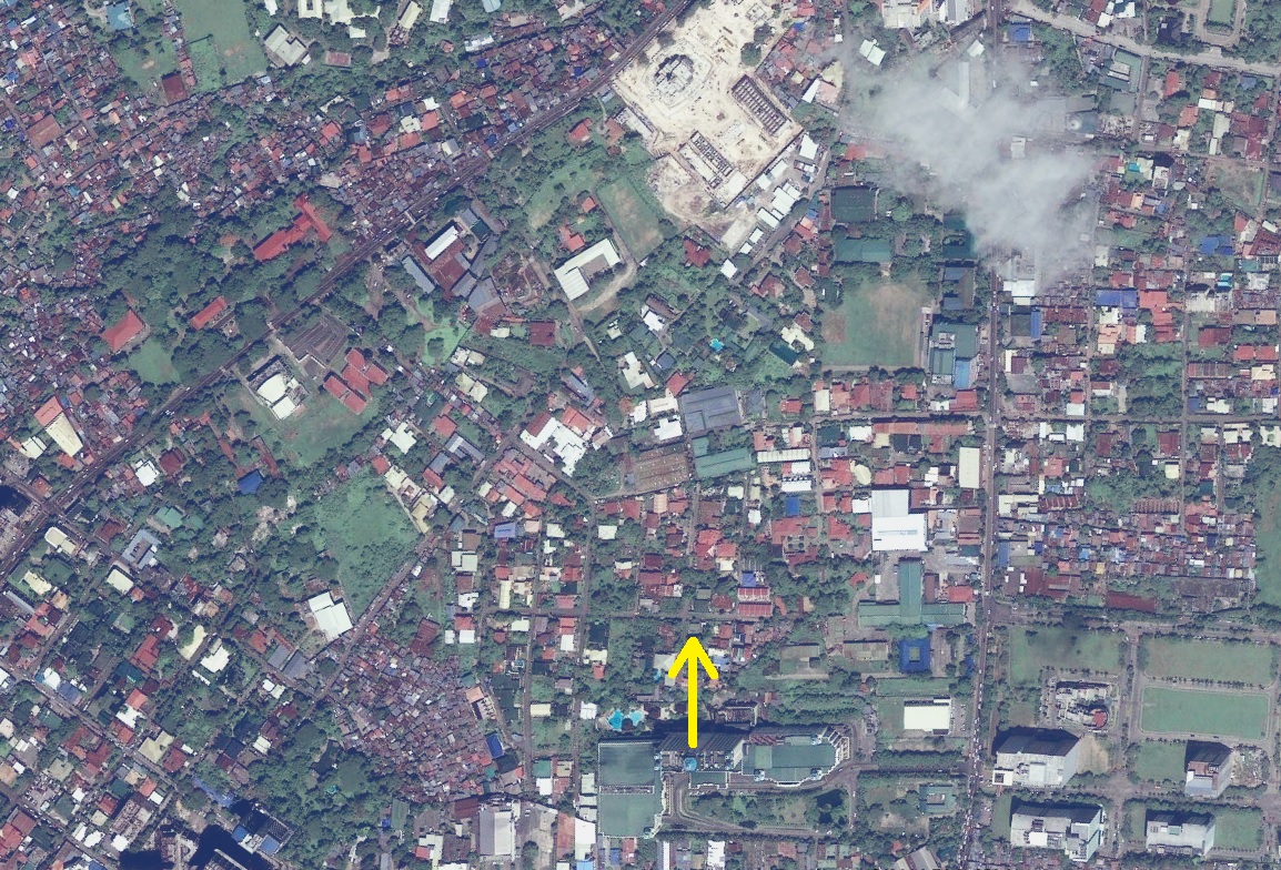
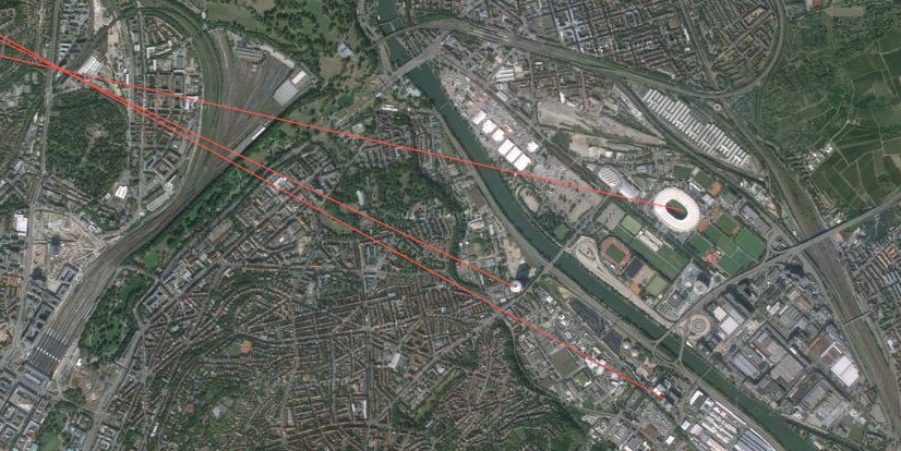
This week’s contest was done in a rush on Tuesday morning because I was out of town for the MLK holiday in a surprisingly cold Miami.  At first I was lost on this one, but the green roof, the hills in the distance, and the buildings made me think somewhere in Germany.  Then I noticed the stadium in the middle and started looking for stadiums in Germany with that profile.  Thanks to some Wikipedia and Google image searching, I settled on the Mercedes-Benz Arena in Stuttgart. From there it was about 20 mins of Google maps searching to find the right building, the BülowBogen Business Center located at Heilbronner Strasse 150. The picture was taken from an office on the back side of the building overlooking the train tracks.  Based on the height of the power lines for the train, it was probably taken from the sixth floor in the building’s southern half:

Stuttgart 2

A few other readers also correctly answered the BülowBogen building:

The electrified railway in the foreground looked like Germany to me, as did the yellow-brick stone buildings with (partially) skylighted roofs that look like the typical industrial architecture in so many railroad adjacent industrial areas from the late 19th / early 20th century. However, these indicators were only good for a first guess. What gave it away was the quite distinguishable top of a stadium in the medium background. That and the hills in the far background limited the choice of possible cities. The stadium in the medium background is Mercedes-Benz-Arena, home of German Bundesliga soccer club VfB Stuttgart. The BülowBogen Business Center is the only higher building in the vicinity of the point from where the photo could have been taken (3rd or 4th floor maybe). On Google maps’ satellite view, the black office building on the right is still under construction.

I wanted to attach a screenshot from Google Maps with arrows and circles and stuff as so many do at these contests, but the distance between point of photography and stadium was too big to be informative. Also FYI: I was given a one-year membership as a present last Christmas. Now, this is my first TVFYW contest I participate in. Good luck to you guys in your efforts!

Thank you! As far as the winner this week, the following reader guessed the closest floor of the BülowBogen building, has participated in the highest number of previous contests among this week’s finalists, and produced the most detailed entry:

stuttgart

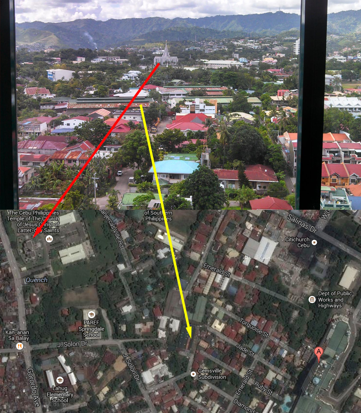
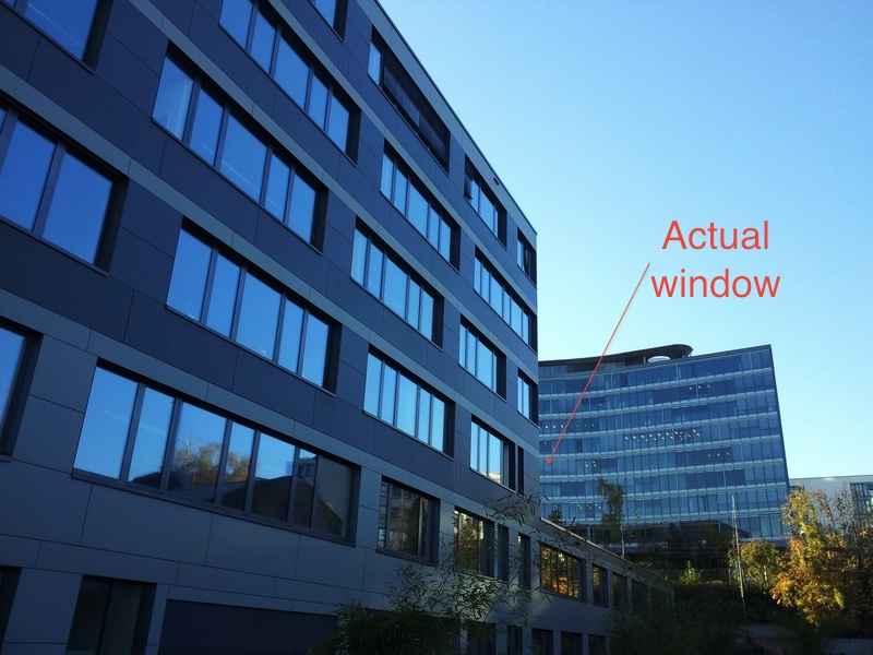
The view is of Stuttgart, Germany. You can see the stadium vaguely in the background. It’s near the Mercedes-Benz factory (which the stadium is named after). I thought it was weird to see a professional sports stadium without any large buildings or skyscrapers around, and that was a tip that this isn’t a view of an American city. So what sort of small towns have professional sports stadiums? Numerous cities in Europe. The shed like structures are actually some sort of music venue and restaurant space called the Wagenhallen – photos of it here.

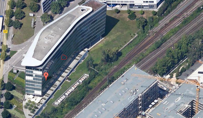
The picture itself was taken from the BulowBogen Business Center at 150 Heilbronner Strasse. I believe the room that the photo was taken from is on the fourth floor. I’ve attached a photo of the building with an arrow pointing to my best guess at the actual window your picture was taken from:

Actual window

From the submitter:

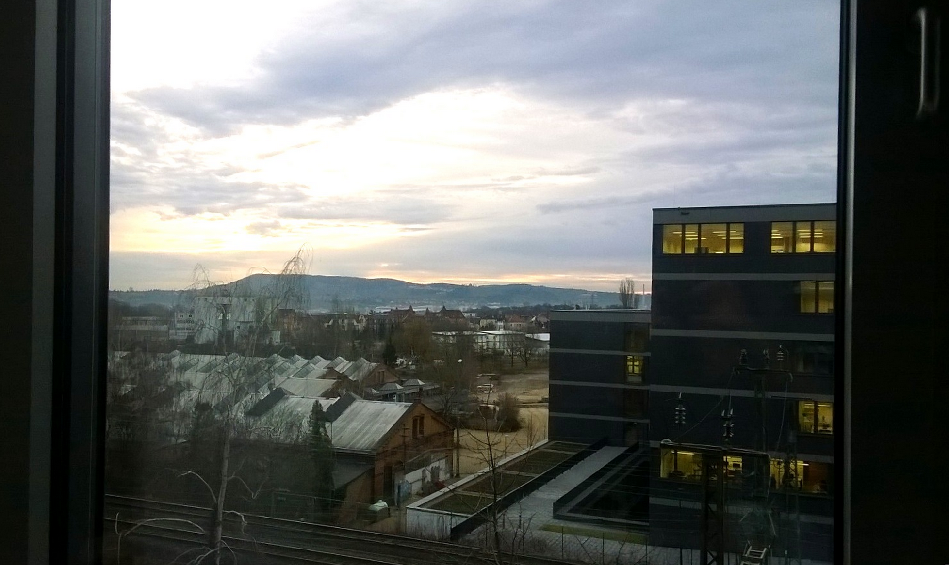
I’ve sent similar shots from my workplace before, but I particularly like this one, with the early-morning sky and the lighted interior of the nearby vocational school. Location: Stuttgart, Germany, taken from the second floor of the Bülowbogen office building at Heilbronner Strasse 150. Time: 8:45 am, Jan. 9, 2014. Description: Directly adjacent to the railroad tracks on the right is a recently built vocational school. To the left is a late-nineteenth century railroad car depot which is now being used for artist ateliers and various cultural events. In the far distance along the Neckar River (not visible) is the Mercedes-Benz Arena, where the local Bundesliga team plays. The area in the middle distance will be undergoing a radical transformation in the next several years because this belongs to the development site of Stuttgart 21, a controversial and very expensive project in which the current above-ground railway station will be transformed into an underground station, freeing up the immense area taken up now by tracks for new development close to the city center.

(Archive)

The View From Your Window Contest

vfyw_1-18

You have until noon on Tuesday to guess it. City and/or state first, then country. Please put the location in the subject heading, along with any description within the email. If no one guesses the exact location, proximity counts.  Be sure to email entries tocontest@andrewsullivan.com. Winner gets a free The View From Your Window book  or two free gift subscriptions to the Dish. Have at it.

The View From Your Window Contest: Winner #187

vfyw_1-11

A reader writes:

Okay, if that ain’t the angel Moroni on top of that spire in the distance, sitting on top of a structure looking very much like a Mormon temple, then I don’t know what that could possibly be.  The surrounding area looks a lot like San Jose, Costa Rica, but given that the temple in that city doesn’t look anything like the one in this picture (according to the LDS website), I’m going with Tegucigalpa, Honduras, looking south towards the temple from the Colonia Ciudad Neuva, off Calle de Los Alcaldes.

Another:

The LDS temple is first big hint. The church is growing/recruiting heavily in the South Pacific. Quick search of LDS temples in this region returns Apia, Samoa as a pretty close match. Not that many tall buildings in Apia, so perhaps the photo was taken from one of the hotels on the water.

Another Samoa entry:

This LDS temple looks closest.  So I’ll guess that the photo was taken from the Tanoa Tusitala Hotel at Beach Road, Sogi, Apia, Samoa, 7th floor.

Another reader:

I’m a low achiever with these contests. I basically just ask myself, “Does that look like Brazil? No? Well then, who knows.” But this was one of the ones that did look like Brazil, in particular, southern Brazil, and I even noticed that, hey, that’s a Mormon temple! So I googled for a minute or two and decided Curitiba, Brazil. Good enough for this week.

Another:

Mountains in the background and a Mormon temple a few blocks away?  Provo, Utah, OBVIOUSLY (they must be having a mild winter).  Try to make it difficult next time!

Another continent:

This is Kiev, Ukraine, looking toward the newly constructed Mormon temple.  Angel Moroni clad in gold on the spire is a dead giveaway.

Another:

Though I’ve never seen any photos of the city before, it took me two minutes to determine it is a view of Accra, Ghana. A Mormon Temple in a non-US tropic setting is a huge clue, needing only a cross reference to an LDS temple photo site. Pinpointing the window’s location is a little harder. I’ve decided that it is a view east looking toward the rear of the Temple from the area of the Accra High School, probably the Alisa Hotel North Ridge 3rd or 4th floor which I see is between the school and the temple on Google Maps. I can’t get more exact than that.

Another gets a tad frustrated:

It’s official. I hate you.

I spotted this one and thought, “This’ll be a snap. I won’t win, of course, because I won’t create a map with animated arrows and GPS coordinates and a story of how I recovered from dengue fever in a room on the floor below.  But at least I will have the satisfaction of getting the location right.”

Why did I think it would be an easy one?  The Mormon temple.  Having been married in one (the first time), it popped right out at me.  Mormon temple, tropical setting in developing country … how many can there be?  Too many as it turns out.  I went to www.ldschurchtemples.com and looked at photos of every temple they have that was even a remote possibility.  Wasn’t as easy as I thought.  Looked at every damn tropical spire where Moroni would be sweating in the tropical sun and NONE appeared to be a match.

Hence my hate – enticing me to waste two hours looking at pictures and Google Earth and getting basically nowhere.  You’re an awful man.

Guayaqui, Ecuador seemed the closest.  But I don’t think it’s right. Fuck.

Another:

I used the helpful LDS world map to figure out where this might be. The closest match to me looked like Cochabamba, Bolivia, possibly taken from the Instituto Americano. The map is an interesting look at where the Mormons have been more (or less) successful. Africa only features three active temples, for example, while Oceania has 10 and South America 15 (with 7 under construction). Asia only has 9 temples, with none in China (unless you count Taiwan) or India. Anyway, if I’m not right, I know more now about the Mormon global presence that I normally would have, and those kind of random learnings are what I enjoy the most about the VFYW contest.

Another nails the right city:

OK, I have enjoyed this contest for years and continue to be amazed at how your readers meet the weekly challenge. First clue in the Jan 11, 2014, image is the greenery. No Polar Vortex. Second, the white spire in the center of the image. It looked similar to the LDS temple I have seen here in Albuquerque. The Google search “white Mormon temple” brings up the church’s locator map, which kindly furnishes an image for each existing temple. From there, it is deduction. Not South America, not Central America, not Mexico, and not the Caribbean.  A journey to Asia puts us in the Philippines, and … Oh, hello, Cebu City.

Next, it’s a matter of locating the rooftops and streets on the Google Map satellite image. The image is taken from a high vantage point, and the websites for the area budget hotels didn’t appear to have the same window frame as the one in the contest image. So, guessing on the exact location, I wager it is the Waterfront Cebu City Hotel & Casino, from the, um, lucky 7th floor.

Mormons and gambling. Nice one.

Another:

After a couple weeks of near-impossible ones, this was a nice reprieve. The Mormon temple in the middle was the dead giveaway. I did my undergrad at UCLA and there’s a Mormon temple in West LA that looks strikingly similar in style. The scenery screamed Asia to me, so on a hunch I googled “Mormon temple Philippines” and voila, our beautiful temple showed up:

unnamed

I’ll bet I’m not the only one who made the Mormon connection, so something tells me you’re gonna have a host of correct answers this week!

About 200 in fact. Another Cebu City entry:

That view of the lovely church just screamed out to me, “Mormon Temple!” perhaps because just a few days ago I saw the raucous (and highly offensive – in a good way) “The Book of Mormon” in San Francisco. And the tropical feel of the surroundings led me in just a few clicks to the Mormon Temple in Cebu City, Philippines, which can be seen clearly from the Waterfront Cebu City Hotel and Casino. A similar photo was posted on Trip Advisor by someone staying in room 803 last August:

Waterfront_Cebu_City_Hotel___Casino_-_Hotel_Reviews_-_TripAdvisor

Based on the perspective from that room, I’m guessing the VFYW hotel room was on a higher floor and to the north, so I’m guessing Room 1127 of the Waterfront Cebu City Hotel.

Another:

I’ve never been any good at solving these VFYW locations, but the scenery looked vaguely like some of the towns I used to travel to when I lived in the Philippines as a child. We’re talking 35 years ago, so my memory is very fuzzy, where to begin? The church in the background didn’t look familiar to me, but with so many beautiful churches across the country, I thought a Google image search might yield something. Nada. Upon closer inspection of the photo, I thought the building looked more like something the LDS church would build, so I googled “LDS temple Philippines”, and found several photos of an LDS temple in Cebu City that looked like it could be a match:

mormon-temple-Cebu-Philippines1

I actually visited Cebu City in 1979, but as you might have guessed this temple hadn’t been built. Apparently the temple was completed in 2010. With the address in hand (Gorordo Avenue Barangay Lahug 6000, Cebu City, Central Visayas, Philippines) it was on to Google Earth, where I see a hotel just a mile or so southeast of the temple. I believe the photo was taken at this location, The Waterfront Hotel, 1 Salinas Drive Lahug,, Cebu City, Cebu, Cebu, 6000, Philippines. My best guess is the photo was taken from a guest room on the eighth floor or above.

Win or lose, it was fun to take this little trip down memory lane. Thanks!

A visual entry:

Cebu map

Only one reader guessed the exact room number, and his entry was short and sweet:

Window is in the Waterfront Cebu City Hotel in 1 Salinas Drive Lahug Cebu City, Philippines. Nice view of the LDS Temple. Just guessing the room #1417.

Great guess! From the submitter:

I’m in Cebu City, Philippines for my brother’s wedding tomorrow. This view is from the 14th floor (room 1417) of the Waterfront Hotel and Casino City Center, looking west towards the mountainous interior of the island. It’s my first time in this country and seeing the widespread poverty surrounding the pockets of wealth is shocking.  Cebu City is the “headquarters” of typhoon relief, with an international airport able to handle cargo planes and relief workers (and John Kerry – insert joke about his ego). My flight on Monday had a group of workers from Hungary. Oh, and the city was affected by the earthquake a few months ago, too.

By the way, here’s the entry from Chini, who basically has a permanent place in the contest at this point:

The last time the VFYW contest was in the Philippines (VFYW #153), it was an absolutely brutal challenge to find the right spot. But this one was far easier, thanks mostly to the Mormon temple sitting smack dab in the middle of the frame. This week’s view comes from Cebu City. The picture was taken from the Waterfront Cebu City Hotel and Casino from, let’s say, the 12th floor. The view looks west north west along a heading of 296.5 degrees. A marked overhead view and a pic of the possible window are attached:

VFYW Cebu City Overhead Marked - Copy

(Archive)