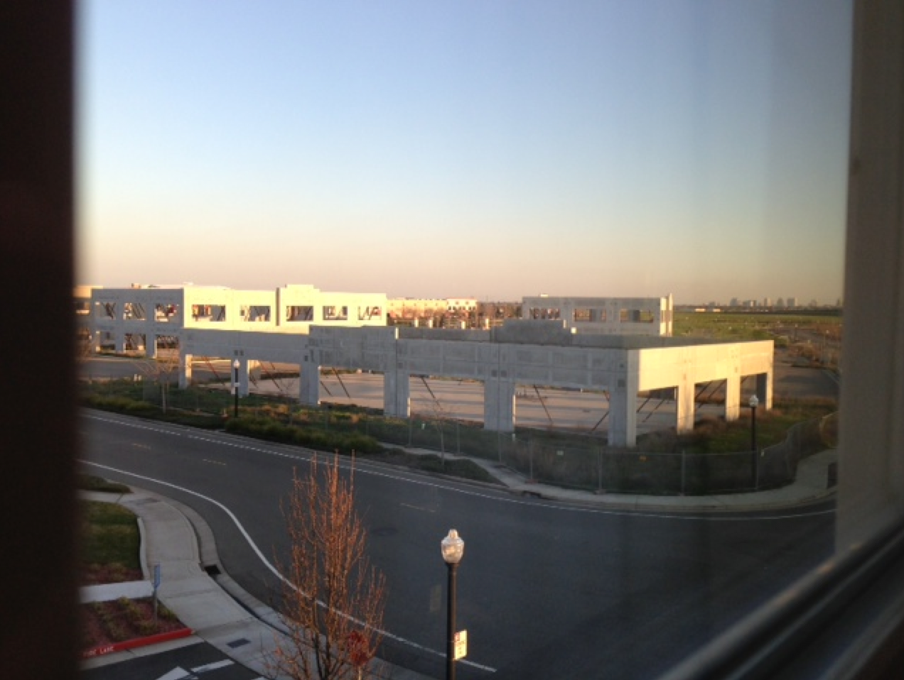
Flagstaff, Arizona, 10.05 am
Flagstaff, Arizona, 10.05 am
A reader writes:
I see we’re going back to harder contests after the hundreds of winners in the previous weeks. The street light, no standing sign, and fire lane tell me that this view is definitely somewhere in the US. The haze in the distance kind of reminds me of the exurban areas of Los Angeles. So I’ll guess Riverside, California, and leave it at that. I don’t think 10 hours of internet searching would get me any closer. Perhaps this is one of those construction projects that stopped mid-recession and never got started again?
Another:
Has to be Las Vegas! All the tells are there: the American “no parking” sign and lamppost; flat barren landscape, the big city buildings in the distance. This must be some of the construction that surrounds Las Vegas, started in the boom times and stopped suddenly when everything crashed. As you fly into Las Vegas you can see how the outskirts of the city were once being developed, housing subdivisions that have streets and sidewalks, but no houses (or even worse, one or two houses in an otherwise empty development). I’d give 10:1 odds that I’m correct!
Another:
Tough one. I was going to guess Fargo, North Dakota, because the land is dead-flat and there’s so much new construction going on there, but there’s no snow. That skyline in the background looks a little like Tulsa, and that’s what I’m going with.
Another:
Just a wild guess mostly, but it is obviously a picture next to a decent, but not overly large, city. The skyscrapers are tall enough to give a good view from ~5-10 miles away. The signs are English, and the climate seems to be similar to that of Texas, warm and relatively dry. Since it doesn’t seem the downtown is either dense, or large, enough for Houston or Dallas that leaves San Antonio. Now to see the e-mail from someone who picks the exact window.
Another:
SXSW started this week, and as I have no clue where in the world this is, why not guess Austin, Texas?
Another:
This picture feels like the Meadowlands area. The long expanse of undeveloped. swampy-looking land leading up to a series of nondescript urban buildings. A Google image search suggested this hunch might be correct (e.g. see attached – source here). Other clues: the “fire lane” marking puts us in an English-speaking country, and that no parking sign looks like the ones in the NYT metro area. the town that the Meadowlands are in is called East Rutherford, and a Google Maps search of it shows certain sections that appear isolated and with long windy roads.
Another:
I would rate this one as nearly impossible. A flat area in the US. It’s a new office park, or something similar, so perhaps a growing area. A few medium sized buildings in the background. I’ll take a wild stab and guess Lincoln, Nebraska, somewhere near I-80 and Hwy 77.
A reader nails the right city:
I immediately thought “Sacramento, CA” when I saw this photo. Unlike most of America at this time of year, California’s Central Valley is green. My wife and I lived in Sacramento for two years, and we would visit Davis, CA as often as we could (they have a great Farmer’s Market). From the east side of Davis, you can often see Sacramento in the distance; so I’m going with Davis, CA, near El Macero Estates.
Another:
For the first time ever, I think I recognize the location. It looks like it was taken in Elk Grove, California, a suburb south of Sacramento. That looks remarkably like the half-finished, abandoned mall at the south end of the city limits. But I don’t recall there being any buildings near that lovely wasteland that are actually occupied as residences or businesses. Still, it does look like Sacramento’s petite skyline in the background. Unfortunately, there are probably several places around here that would allow a view such as this, and around the country as well. At least I finally have a guess based on more than intuition.
Another:
Around Sacramento stalled developments were a common site. Though many of the housing projects have started up again, check out this similar pre-ruin south east of Natomas in Elk Grove:
Neither project has moved an inch since the financial crisis.
Another gets the right part of Sacramento:
This area is called Natomas and the hotels serve the Sacramento International airport near by. Two doors down is a hot dog place with late night drive through. For years these building skeletons have waited for real estate to turn around. The blocks are sketched out and the cement sides raised but there hasn’t been the money to finish them. I’ve stopped there at dusk before to look at them. To the north are the rice fields of the Sacramento valley. Natomas grew from the fields in a few decades and the effect, along with the half constructed buildings has always brought Caffa to mind- the outpost remade by Venice and then the first to collapse under the plague.
Another adds, “The empty development is locally known as “Stonehenge,” or sometimes, “Natomas Stonehenge.” Another:
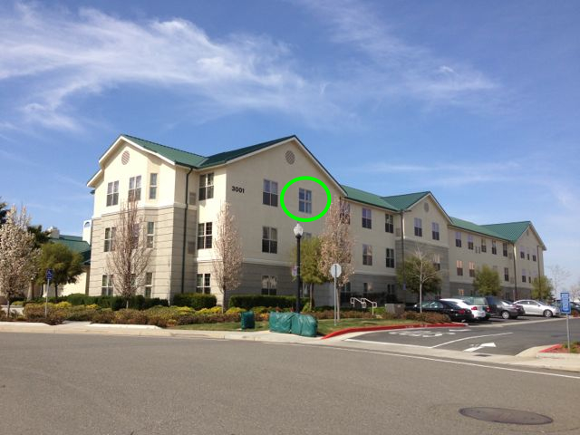
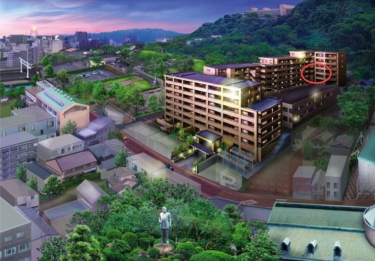
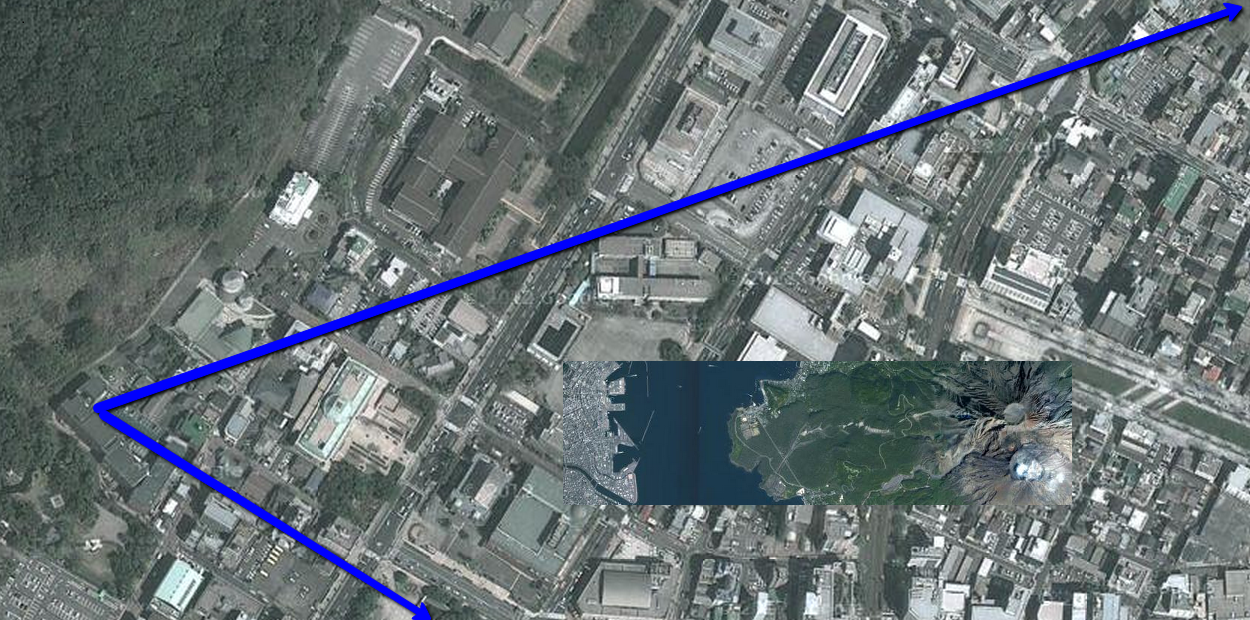
First-time participant here, I never thought I would be able to correctly guess a VFYW contest. The picture was taken at the Homewood Suites in Sacramento, CA. I will try to be as specific as possible since I am sure anybody who stayed there might remember the location: the second floor, on the southeast side of the hotel indicated by the arrow in the attached picture:
I stayed there a couple of years ago on a business trip and I remember jogging around the area.
So very close – it’s actually the third floor. About a half-dozen readers correctly guessed that floor, but none of them have guessed a difficult window view in the past (“difficult” defined by only ten or less correct answers), so breaking the tie is tough again this week. But the following entry was the most detailed and proactive of all:
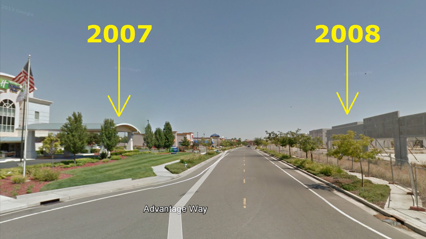
Since I live in an eastern suburb of Sacramento, my first reaction was, “Wow, there are dozens of these abandoned developments all over the Sac region; there’s even an entire mall.” Then I noticed that the city skyline looked familiar, the tree was budding, grass/weeds growing; plus the No Parking sign eliminated a large chunk of the world. So Sacramento in early March seemed like a possibility.
A quick scan of Google Earth and a comparison to various skyline images confirmed that the image must have been shot from the north toward downtown (sunset shadows and open space were clues). After a few more minutes map-scanning, I was confident I had it thanks to the sidewalk design, driveway arrows and landscaping. So it’s Homewood Suites (a hotel) at 3001 Advantage Way in Sacramento, CA. And my hunch was that it was taken from a window on the 3rd floor:
You might find it interesting that the commercial structures mask a view of one of our many housing failures in the region. An entire neighborhood of streets, utilities, house foundations overgrown by weeds, and most striking – a small community center and swimming pool that’s abandoned and deteriorating. Looks like the developer sold five townhomes before shutting down; they appear occupied, so I hope the owners aren’t paying HOA fees for that pool.
By the way, my 3- and 6-year-old daughters and I (ok, mostly me) decided to make an adventure of it and attempt to see “The View TO Your Window.” We didn’t expect to replicate the view FROM, but fortunately, this is a window in an open-space hallway on the 3rd floor, just outside of room 301 (and the hotel staff were very friendly):
My 6 year old, comparing the original image on my phone to the actual view, thought it was amazing that “we found the match.” Then she immediately asked, “What will we do if the next picture is in China? Will we go there?”
Thanks for spawning a fun excursion for the three of us. (Mom thought we were crazy.)
Congrats, we’ll get a book prize to you soon. One of the contest’s most consistent winners adds:
The site is probably familiar to local basketball fans, as Arco Arena, home court of the Sacramento Kings, is visible rising behind the unfinished buildings on the left. Because the Kings will likely be sold this year, the city is actively working on development plans for the surrounding area. As for the unfinished buildings, they were originally supposed to house a TGI Friday’s, a Sonic Drive In and healthcare buildings, but the recession drove the developer into bankruptcy.
Could there be a better monument to the last decade than the half completed shells of suburban chain restaurants and medical offices? The street in front of your viewer’s hotel is named Advantage Way, but it’s really the high-water mark of an entire era.
The photo submitter’s entry, for the record:
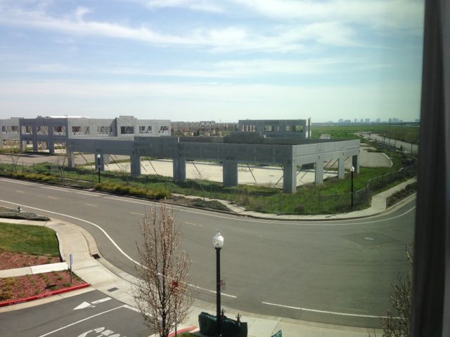
Sacramento, California, 5pm on 2/13. Looking from 3rd floor of the Homewood Suites in Natomas. Someone had great plans for a development in this area – foundations are laid, streets have names, but it apparently came to a crashing halt. I’ve been coming here on business for 7 months and it’s been like this since then. You can see the slightest sliver of the (hilariously named) Sleep Train Arena, home of the threatening-to-move-to-Seattle Sacramento Kings.
Update from the submitter:
The guy who won was exactly on target: I took that photo from the hallway window near room 301 of the Homewood Suites. I’m delighted to hear that he went there with his daughters. I’ll be back in that hotel on Monday and will let the staff (who know me by now) know how this all came about. Extra fun – thanks!
(Archive)
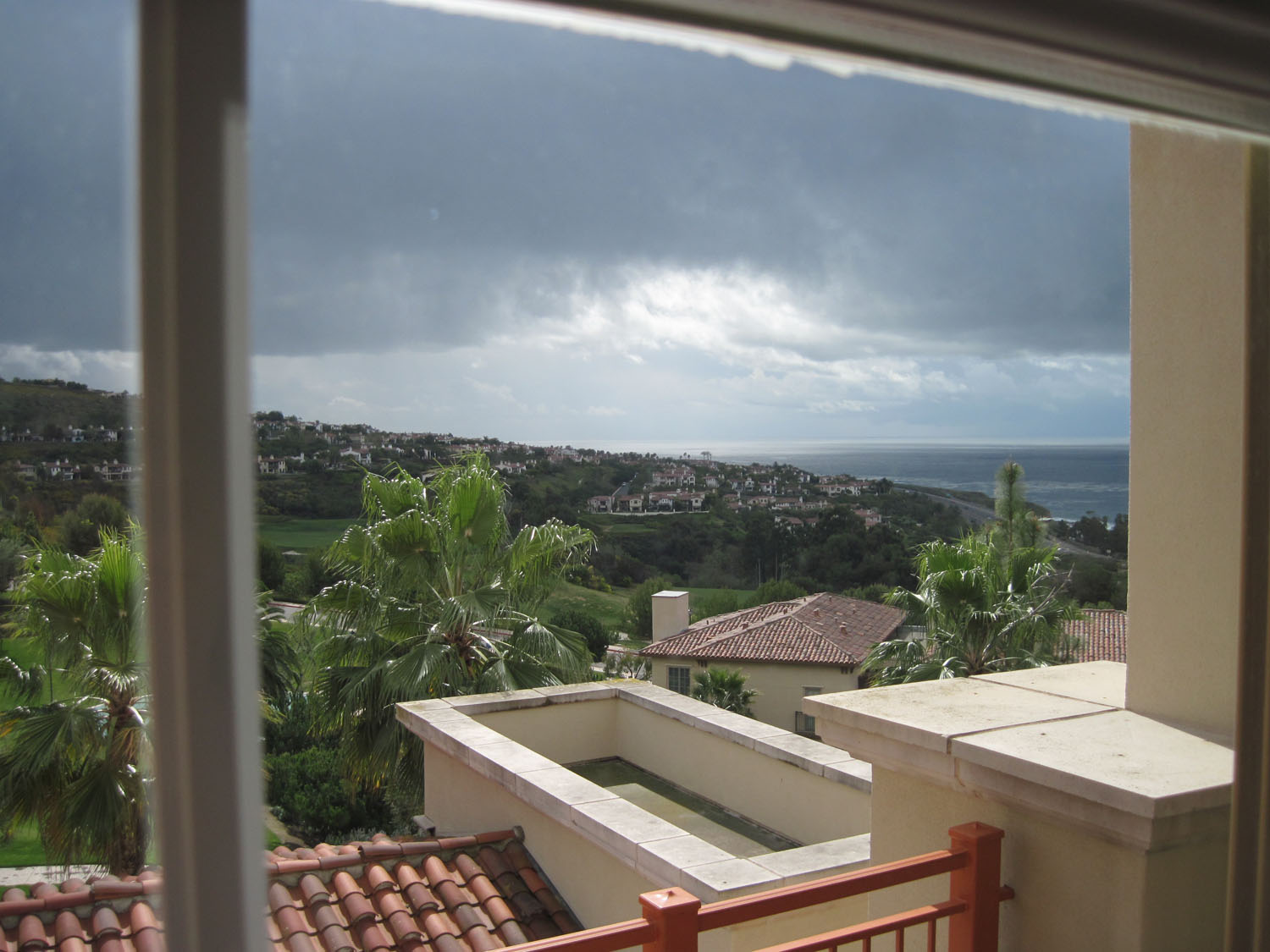
Newport Coast, California, 10.02 am
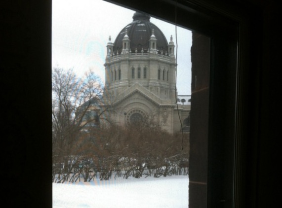
St. Paul, Minnesota, 12 pm
You have until noon on Tuesday to guess it. City and/or state first, then country. Please put the location in the subject heading, along with any description within the email. If no one guesses the exact location, proximity counts. Be sure to email entries to contest@andrewsullivan.com (the old address still works as well). Winner gets a free The View From Your Window book. Have at it.

Los Angeles, California, 1.13 pm

Buenos Aires, Argentina 5.30 pm

Charlottesville, Virginia, 8.01 am
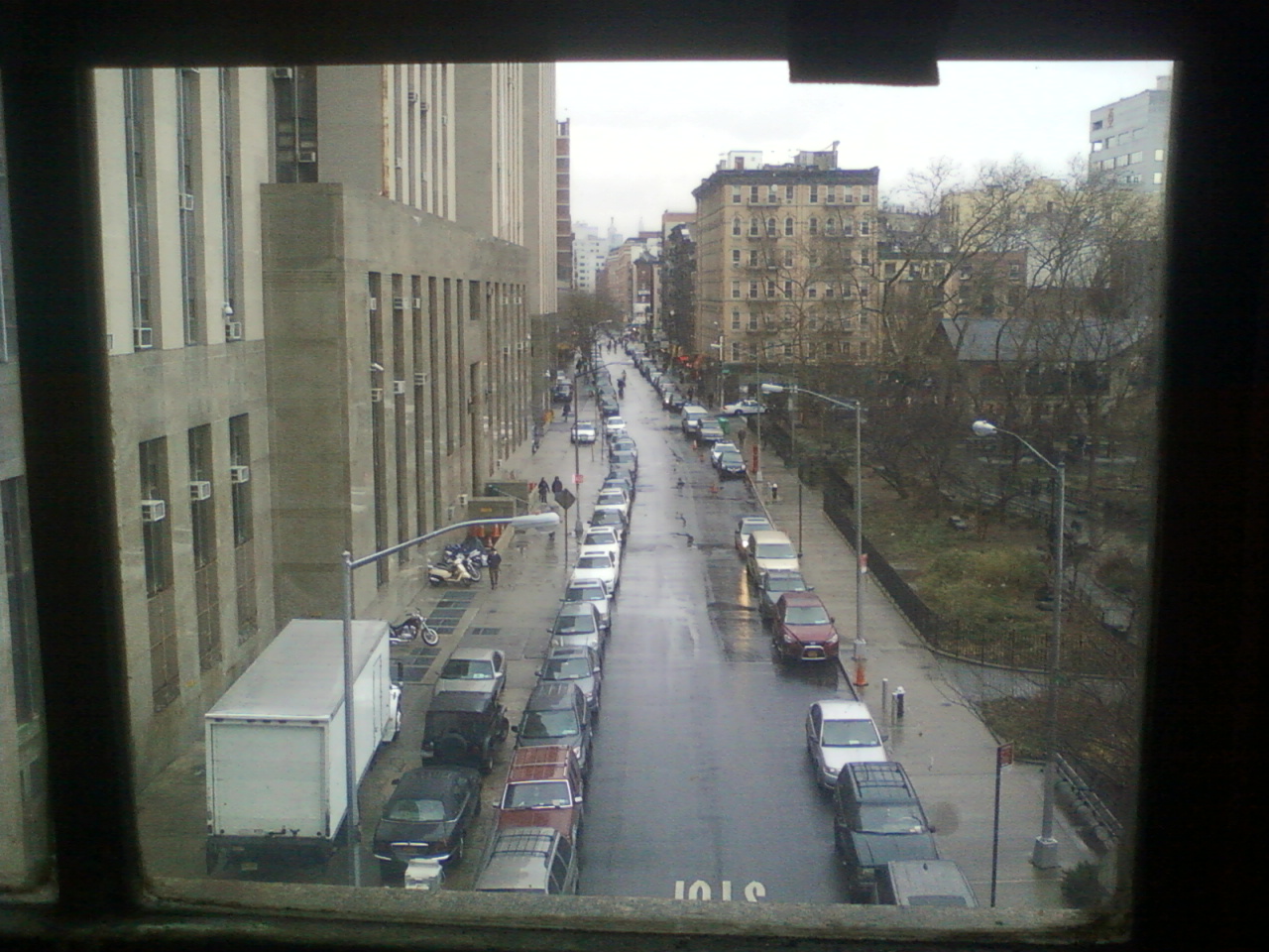
New York, New York, 4 pm
A reader writes:
Perhaps its something like familiarity bias, but I’m always struck by how many images look like my own locale, Southern California. This view with the large grey mountain in the background, the cars in the foreground, the palm trees in the mid-view, could be a suburb of Los Angeles. But there is a pagoda-like roof to the left, and a Islamic looking tower in the mid-ground, and I’m going to go with Tehran, Iran.
Another:
I’ve never put in a guess on one of these before, but I just passed through Puebla, Mexico the other day and it has a volcano similar (indeed, identical, hopefully) to the one in the picture.
Another:
Olympia, Washington? I couldn’t find the exact house, but isn’t that Mt St Helens? With no snow?
Another:
If not Naples itself it is one of the surrounding cities. The mountain in the background is Vesuvius, unless of course I am wrong. I spent a day at Pompei and saw it from many views. It wasn’t until later in the day that I realized the peak I’d been centering in my photos was only the far right side of what was left of the mountain. It was with that realization that the full magnitude of the event hit home as you could see there was a huge piece of the mountain that is missing.
Another is on the right track:
This has to be Japan. There’s the characteristically roofed building in the lower left hand corner, the boring modern sameness of all of the building you see in the skyline, the cars all small, sleek and new. I looked at a topographic map of Japan to see which cities would be surrounded by nearby visible mountains. After guessing around a bit I found a photo of Fukuoka which seemed to match the flatter topped mountain in the background.
Another:
It’s 1:05 a.m. after a birthday party in Montreal, and I should know better than to take a crack at a VFYW contest on a hunch, but here goes. The clay tiled roofs and right-hand drive cars suggest Japan. The palm trees and exposed staircases suggest a southern climate. The urban density says a large city on a southern Japanese island, and that suggests Naha, Okinawa. And now I’m going for some poutine (cheese-curds, gravy and French-fries – renowned Canadian hangover cure!)
Another:
Here’s why I love this stupid, awful contest.
Since Saturday I’ve learned that the ugly institutional Soviet-style architecture I’ve hated my whole life is called Brutalism, I’ve learned that the Scion line is only sold in North America, that Grupo Bimbo has opened two two bakery facilities on the outskirts of China, and I’ve dusted off some pretty dormant geographic knowledge I once knew by heart and clearly took for granted. I feel smarter for having searched.
Here’s why I hate this fun, stimulating contest. None of the above mattered much in my search, and I’m still left without even being 100% certain of the right continent. My answer may as well be Pangea.
This view is insanely frustrating. It is a terribly ugly city. There are no people in the view. The city is almost entirely bereft of notable signage or advertising. There are cars, but they are all backed into a deck. The roof tiles suggest Asia, as do the few visible characters, but I eventually went crazy and at moments thought those were red herrings too. I have image searched things as varied as Nigeria, East Timor, the suburbs of Beijing, and seemingly every stray corner of Oceania. My wife was convinced one of those horrible buildings was a hospital based on the size of the rooftop access doors, and was Googling things like “asia hospital helipad”.
I’m saying Akita, Japan, or someplace near. I have my reasons but they’re all terrible, and this guess is also I’m convinced. I’m only sending this in because after my wife and I spent most of two evenings on it, I feel I owe it to myself to enter a guess, any guess. I have a list of about 12 questions I need to have resolved about this view, and I’ve probably never anticipated an answer this much.
And somebody was there last week or was best man in a wedding on top of that stupid TV network building looking thing with hardly any windows. Or some other bullshit. I hate that person.
Another:
Fuji-san!! That was my first thought when I first saw the picture. I have seen it from a speeding Shinkansen several times. I knew it was Japan – the cars in the parking spaces looked right – and the vague lettering on the signs too. But the longer I looked the less and less it looked like Mt. Fuji, which is more conical and would certainly have snow on the summit this time of year.
I looked at other mountains … Mount Haruna? No, too flat. Maybe Mount Ontake in Nagano? I looked at a lot of mountains. Then I looked some more, and wondered if maybe it wasn’t Mount Fuji after all. I can find some images that look a little like that. So … I’m sticking with a view of Mt. Fuji, from the city of Fujinomiya.
Another sends a view of the right mountain:

Another identifies the right city:
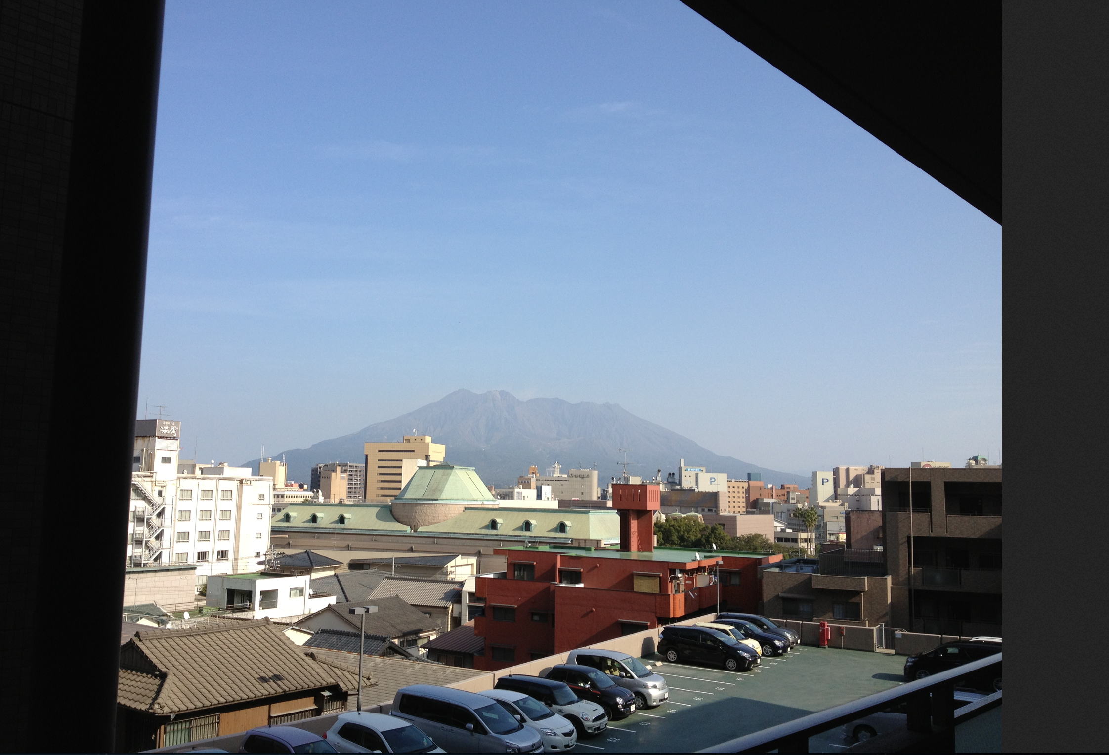
This is the first time I have ever attempted a VFYW. To be honest I never really understood the appeal of internet searching as a form of fun. I always just want to find something, the searching part is actually kind of annoying. However, there were many clues in this view that led me to believe I could be victorious. The lettering on the buildings, the foliage and the FREAKING VOLCANO!
Because of the clues I’m sure someone has already beat me to the location as Kagoshima, Japan. The characters on the sides of the building are nice and friendly, indicating Japanese The right side steering is another giveaway, that and the cars are all new and spotless. I first thought Okinawa Prefecture. Some of these islands are volcanic, but none of the mountains I could find were near city big enough to have multiple tall buildings. I was searching for photos of Okinawa and I stumbled on a blog in English about someone who lives on Okinawa and bam! There is that volcano! The particular post was about a trip to Kagoshima and from there it was easy to locate. The weird green roofed?(color blind) building in the foreground is pretty unique and is the Kagoshima City Museum. There is only one tall building behind it that is either a hotel or apartment building, I’m not sure. When I click on the building in Google maps its says “Kagoshima-ken, Kagoshima-shi, Shiroyamachō.” Whatever that means.
It was a thrill to find it, thanks bunches!
Another:
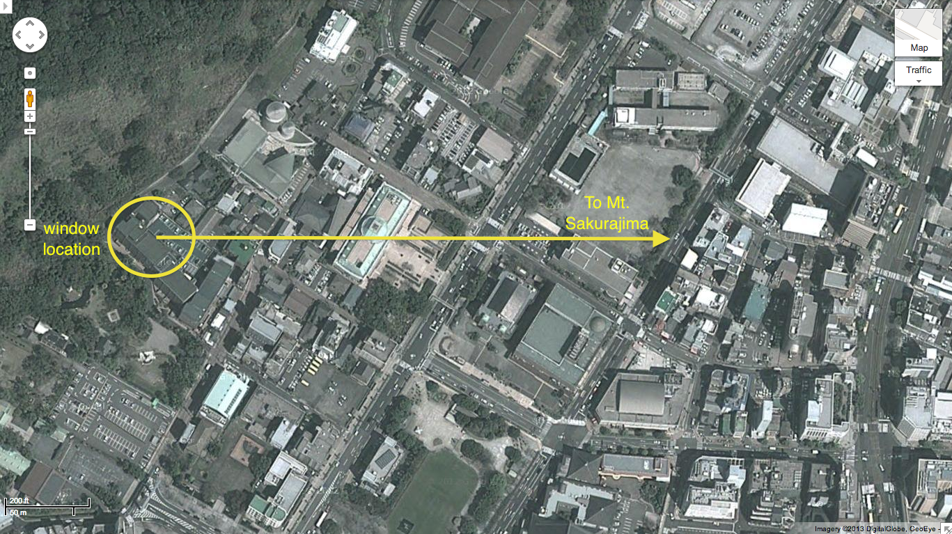
I think this is my fastest ever, less than ten minutes from seeing the contest photo to finding the building from which the photo was taken. I don’t have a story or anything to go along with the guess, but the photo was taken in Kagoshima, Kagoshima Prefecture, Japan, facing east towards Mt. Sakurajima:
Another:
I had a feeling that if I could figure out what the stylized kanji on the left said that it would lead me to the window and I was right! My other Japanese friend and I were able to correctly piece together than the kanji are
満秀
which leads immediately to the hotel Manshu in Kagoshima, Japan!
Another:
Kagoshima is the hometown of Heihachiro Togo, the great Japanese admiral who humiliated the Russian navy at Tsushima. Sakurajima sits due east of the city across a narrow stretch of Kagoshima Bay. Since the view is to the east, we are looking for a part of the city with streets running southwest-to-northeast. A quick aerial tour shows that the oldest part of the city – bombarded by the British in 1863 – fits the bill. The copper-roofed building is the Kagoshima City Museum of Art, and the green-surfaced parking deck in the VFYW’s foreground is plainly visible as part of a large apartment complex to the west. Its address is Shiroyamacho 3-35; Google translates the name of the building as “Surpass Shiroyama Park City.” I’ll say it’s a view from the top floor, about a quarter of the way along the northeast side of the third building up the hill.
Another sends an image of the building:
This one was really easy so I’m sure there will be a lot of correct responses given the amount of signage in Japanese. The photo looks like it was taken from the Surpass City Shiroyama Park apartment building in the Shiroyama-cho district of Kagoshima Japan. Probably from the 5th or 6th floor of the main building or one of the units right above the parking lot. I’ve attached a fun rendering of the building which overlooks the active volcano on Sakurajima.
Another adds:
These are “manshon” or condominiums, one of which seems to be for sale right now for about $226,000. Looks like a lovely spot, and the statue of Saigo Takamori (The “last” Samurai) right across the street adds interest. Somehow I wouldn’t want to test my luck that close to an active volcano, though.
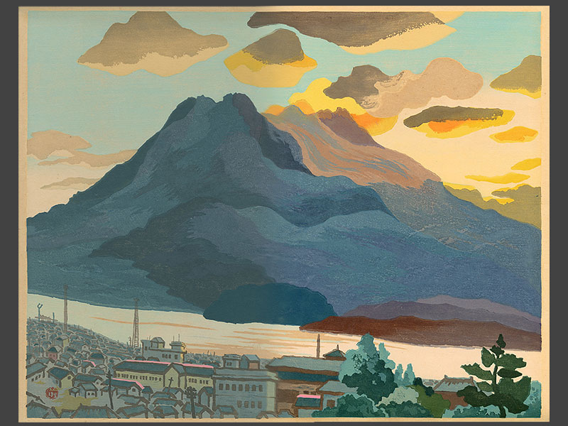
Another sends a painting of the volcano:
Sakurajima in Morning Light, Kagoshima, Kyushu by Toshiro Maeda
Close to 250 readers correctly answered Kagoshima, and a dozen of those have correctly guessed difficult views in the past without yet winning, so determining a winner this week is extremely difficult, especially without knowing the exact floor or unit from which the photo was taken. One Kagoshima guesser goes for bribery:
If I win I will subscribe!
No pay-for-play on the Dish. So to break the tough tie this week, we found the reader among the aforementioned dozen who has entered the most contests overall. The image from that reader’s Kagoshima entry:
Congrats to that reader on the close win. From the photo’s submitter:
My daughter took this picture on February 3 at 2:30 PM. The view is the city of Kagoshima, Japan, looking across the bay to the active volcano Sakurajima, which is only about five miles away. The exact address is 701 Surpass City Shiroyamakouen, 3-35 Shiroyama-cho, Kagoshima. I have no idea what all that means, unfortunately,although the neighborhood is called Shiroyama-cho. People should notice the nearby mountain that is recognizable as a volcano, and the roof in the foreground looks very Asian so I think people may get to Japan quickly, but Kagoshima, onthe southern island of Kyushu, is pretty off the beaten track.
She is studying in Tokyo for her junior year abroad, and is doing an internship for a month between semesters as a distillery in Kagoshima. She likes to look at the VFYW and is always sending me photos asking if this would be a good one, and I finally think she got it right.
Love the contest and the Dish! Of course I’m a subscriber. Also sent you your contest view of Waterton Lake last summer, which thrilled me to see on the blog. Keep it going everyone!
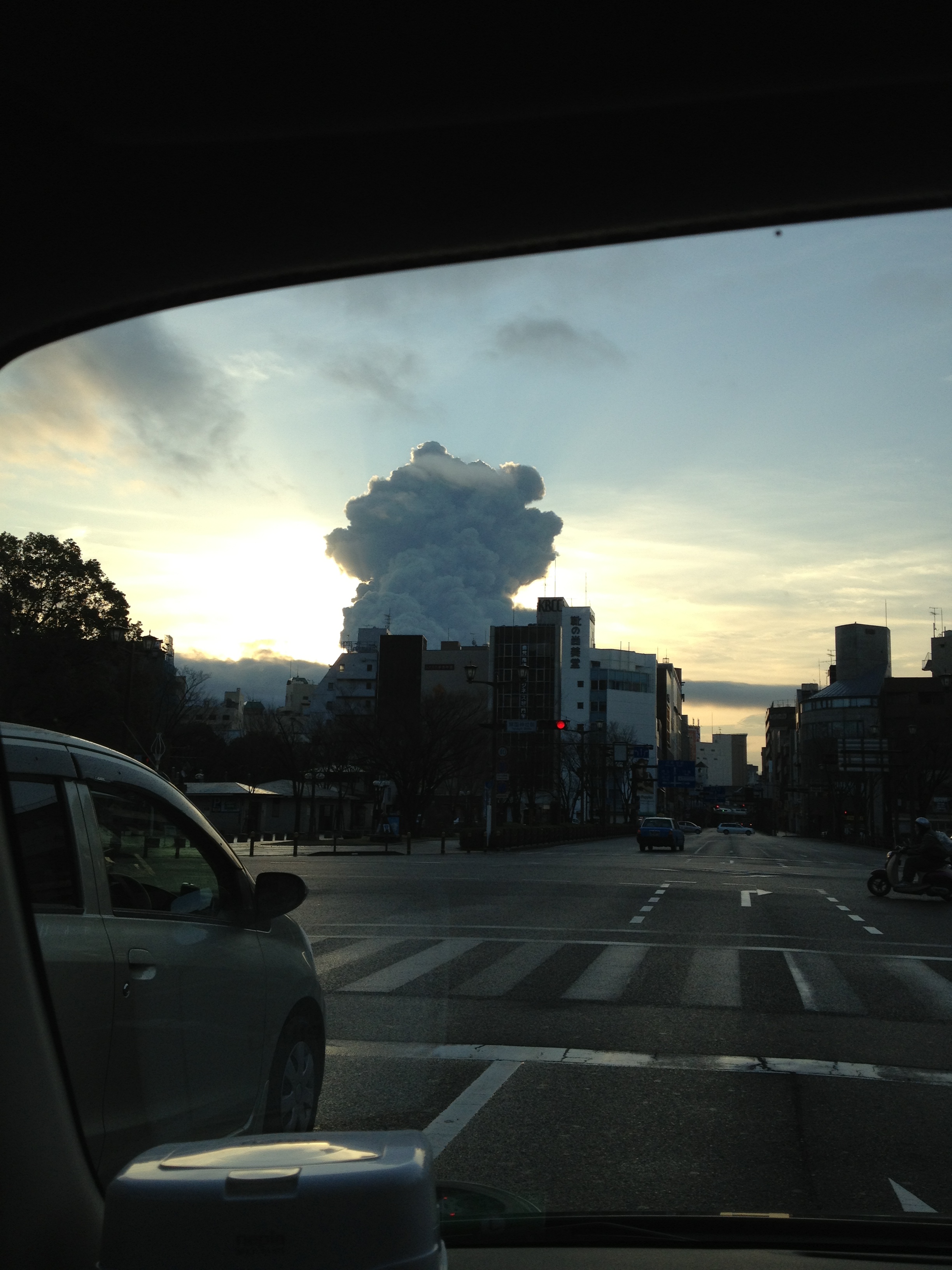
He follows up:
Awesome to see my daughter’s picture of Mt Sakurajima from Kagoshima as this weeks puzzle entry! I thought I’d pass along a new picture she sent me (a view from your car window) of the mountain in a big ashy eruption the other day, taken from the streets of Kagoshima:
(Archive)