A frustrated reader sets the scene:
This one is going to haunt my dreams.
The trash can says “Please Don’t Litter”, so we are in the Anglophone world. The cars drive on the right, so we are most likely in North America. There is gleaming new construction in a super-clean neighborhood, with ample surface parking attached, adjacent to a more established neighborhood that is urban, but not super-dense. Also, slightly hilly. Assuming the photo was taken recently, we are reasonably far south, because everything is very, very green. So … probably the US, in a well-established mid-sized city that has seen some significant growth lately.
That type of new architecture (blocky with lots of glass and slick materials) is, unfortunately, really ubiquitous these days. I’ve seen buildings like that in Seattle, Portland, San Diego, Charlotte, Atlanta, Boston … a couple of weeks ago I passed through Tyson’s Corner, VA, for the first time in a long time, and seems like that is the entire town now. And seriously, that (apparently purely decorative) canal with the fountains in it should make this easy to find, right? Indianapolis (where we were for a gimme window a few weeks back) has one like it, but that’s not it.
I hate giving up on this, but I honestly have no idea. Just so I have something to put in the subject line, I’m going to say Atlanta, since it always seems like they’ve erected some new glass and steel monstrosity every time I go back there.
Another aims for a blue-glass city of the North:
Vancouver, British Columbia, Canada
Or waaay south?
My first reaction to the picture was Auckland, New Zealand. Just a wild guess, but saw a House Hunters International recently of a couple trying to buy a condo in Auckland and this looks similar to one of their views.
Another reader e-mails it in:
I’m resolving to enter this contest every week, even when I don’t think I have a good idea of where the photo was taken. Too often I’ve said, “hey that looks like xxxx, but it’s probably not, so I won’t enter.” Then it turns out to be xxxx. That said, my entry this week is probably wrong. But something about this photo looks like eastern Canada to me, and the English on the trash can rules out Montreal. So I’m guessing Ottawa.
Only a fraction of contestants guessed incorrectly this week. The first of a few hundred correct guessers needed only 14 minutes from when the photo was posted:
Providence, Rhode Island, United States of America
A former resident elaborates:
This photo is undoubtedly of downtown Providence! I have long enjoyed reading the submissions and marveling at those who could identify the far flung places featured in VFYW so seeing my almost home state was a treat.
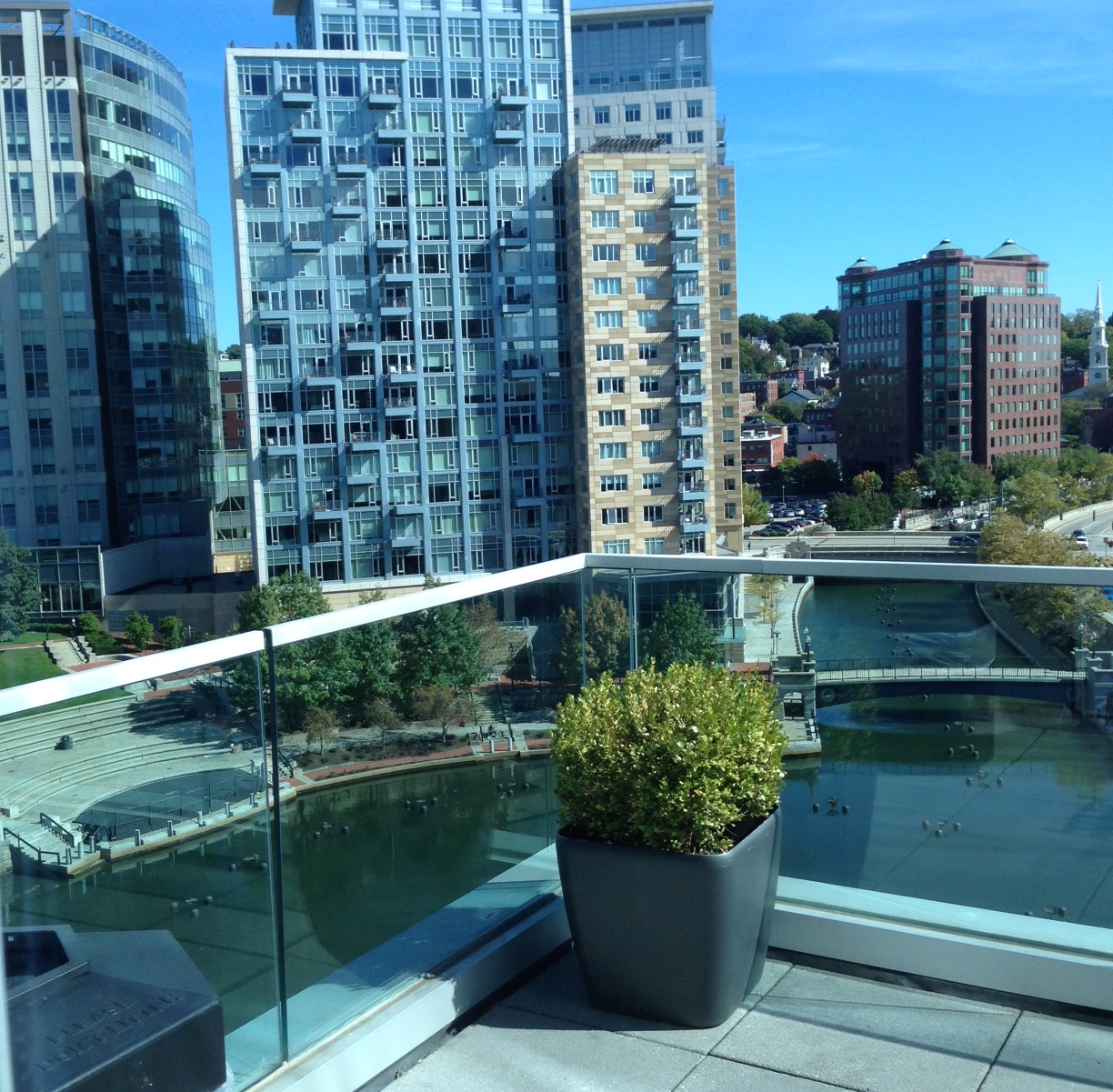
This was taken from the north side of the balcony about halfway up the GTECH building at 10 Memorial Boulevard in downtown Providence. You can see the church I grew up attending far to the right and the river with WaterFire baskets installed below. The red triangular building is home to Cafe Nuovo, which is a great (although I haven’t been in years, my parents go) restaurant.
I grew up in a small town outside Providence, but my parents are professors at Rhode Island College in North Providence, so I spent a lot of time in the city. Buddy Cianci was responsible for a lot of the downtown development that took place in Providence when I was growing up and it’s hilarious to me that he’s running for mayor AGAIN. People love him. I’m not up on all the politics as much anymore (I live in DC now so we have plenty to keep up with here) but I know enough to admit that the downtown area is much more pleasant than it used to be. RI still struggles economically and a half-dozen WaterFire festivals each summer won’t fix that, but it’s a beautiful city with an incredible food scene and a lot of great art in general.

Wondering what a WaterFire basket could be? Dishheads have you covered:
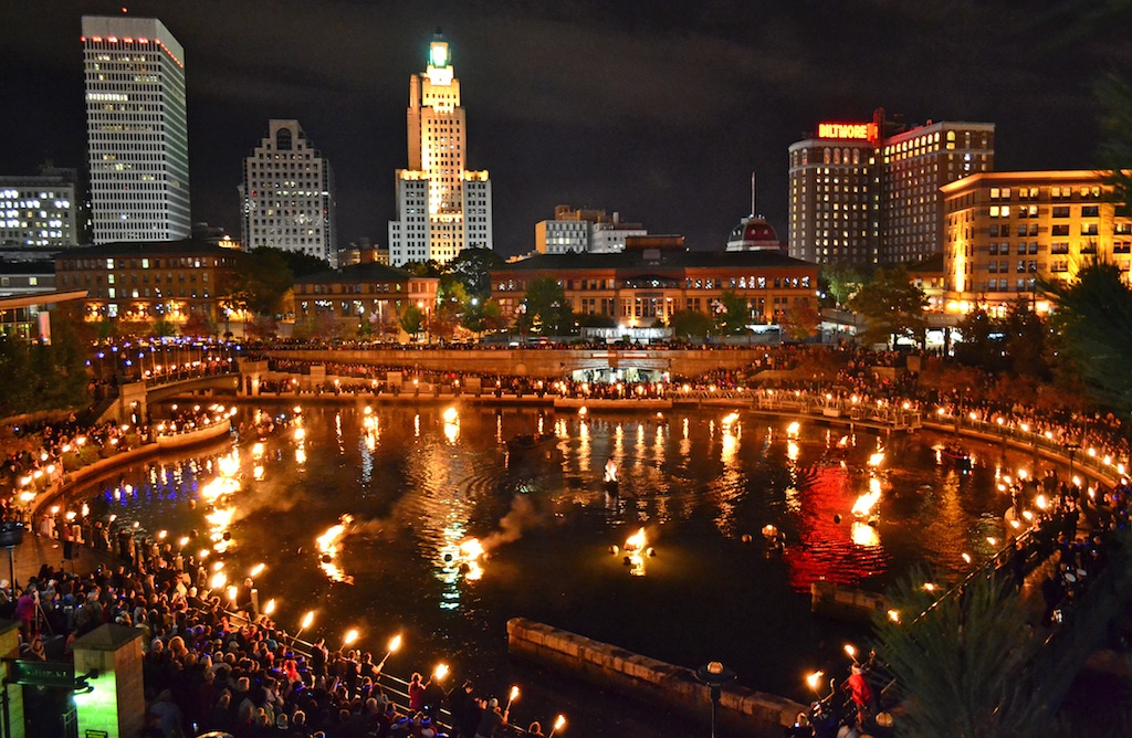
I’m a master’s student studying water quality and sustainability, and I immediately recognized the floating bonfire pits of WaterFire in Providence. In the 1990s, the city daylighted the previously covered Woonasquatucket River and installed the bonfire pits in the river as a civic art project. During WaterFire nights, the city lights fires on the river and it becomes a center for activity in the city. It has been a huge success story for Providence and a model for other cities to rebuild and reinvigorate their downtowns.
Another gives you a look:
The balcony overlooks the circular basin that marks one end of the Fire Water celebrations, where the city builds bonfires in metal baskets set in the middle of the Woonasquatucket and Providence Rivers. Fire Water is the centerpiece of the renaissance of downtown Providence that occurred during the tenure of Buddy Cianci, Providence’s notorious once and future mayor. All of the tall office buildings in the picture were built during that renaissance, in which Cianci spearheaded the redevelopment of the downtown riverscape, which had been covered over for much of the twentieth century. It is extraordinary how much the city has changed as result of the public and private investment in the downtown. It is an amazing spectacle, truly carnivalesque, as well as a brilliant way of bringing tourists and suburban residents back into the city.
More on Cianci in a bit. A former winner notes:
It is probably not a coincidence that this view appeared on the day that “Full Light” takes place and it’s the event’s 20th anniversary. I suspect someone will submit an entry that includes this Saturday’s spectacle.
Total coincidence! And sadly no, it seems no Dish readers were there that night. But another reader is friends with the artist who created WaterFire, Barnaby Evans. Another passed along this video:
A more expert take:
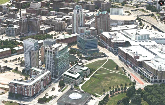
I’m an architect, and at first glance all I saw were those relatively new banal buildings found in countless north American cities. But in the hilly background were some brick and clapboard buildings that reminded me of coastal New England towns such as New London. Of course if you combine coastal New England with a spanking new Riverfront you immediately come up with Providence, Rhode Island, which in 1994 uncovered its long-buried river by removing what was euphemistically termed the “world’s widest bridge.” An aerial view of downtown immediately shows the distinctive basin and amphitheater and that’s all that you need as the balcony of 10 Memorial Boulevard is pretty evident in photos.
Another had more trouble:
I became convinced that the view was looking out over a canal with fountains in it, and started searching based on that idea. There’s a Wikipedia page documenting US canals, which counts over 18,000 of them, although I got the impression most of those are for agricultural use.
As far as the right window, the following entry is probably the closest the contest has ever gotten to accidental modern art:
That entrant adds, “I tried to say “Woonasquatucket” to my wife and she chortled “is that an invitation?” Meanwhile, this reader reminds us about the soul of wit:
Canal. Waterfire. Providence.
Next question.
Another submits in Haiku:
Views of Waterplace
GTECH seventh floor ca-ching!
Woonasquatucket
Some other great entries this week:
What really clued me in on this one was the bush. It’s centered in the frame, very nearly the subject of the photo. It seems to regard the viewer quizzically, “Why are you looking at me?” or rather, and more introspectively and shockingly self-aware, “Why can I see you looking at me?” And its the bearing of the bush, the very regal, upright, staid look on what I can only refer to as its ‘countenance,’ that bespeaks a soul bestirred, a corporal glove filled with a heavenly hand, the capital-D Divine, and when I thought “capitol” and “divine” I realized I was looking at Providence.
Incidentally, I was born in Rhode Island, in the town of S. Kingston, and have long loved the Blossom Dearie tune “Rhode Island Is Famous for You”:
With lyrics like:
Pencils come from Pennsylvania
Vests from Vest Virginia
And tents from Tent-esee
They know mink / where they grow mink / in Wy-o-mink
A camp chair / from New Hampshair / that’s for me.
Minnows come from Minnesota
Coats come from Dakota
But why should you be blue?
‘Cause you / you come from Rhode Island
And little old Rhode Island / is famous for you.
The following reader, as well as most of the numerous Dishheads who went to school in Providence, just needed the steeple to the far right of the image:
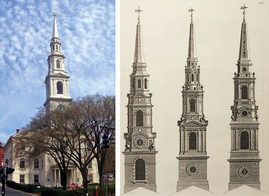
I took the steeple as the most useful clue. Searches for “New England steeple” and “Connecticut steeple” were fruitless, but “Rhode Island steeple” brought me this among the first images (left-most)
This is the steeple of the First Baptist Church in America, built in Providence in 1774-75. But there might be other U.S. steeples that are nearly identical; it is very close to a model in James Gibbs’s classic Book of Architecture from 1728.
More on the church:
The white steeple all the way on the right edge of the picture is First Baptist, as in Roger Williams’s FIRST Baptist parish in America, which, unlike their Southern component’s image nowadays, was a huge mover for religious freedom in colonial (Puritan) New England, and, not incidentally, was the great and wonderful late Rev. Mr. Gomes’s denomination (though his accents and tastes seemed those of a High Anglican).
Another notes:
While the church was started in the 1630s by Roger Williams, the meeting house was completed in 1775. At that time the steeple was erected in three and half days and has ” survived time and hurricanes since then.” Quite amazing don’t you think!
And we learn that Brown’s grad ceremonies happen in that church:
In the far right of the frame is the steeple of the austerely beautiful First Baptist Church in America (located, appropriately enough, on the corner of Steeple St.), where I graduated from Brown University, and which celebrated its 375th anniversary last year. On that occasion, congregant David Coon composed the following:
Who are the members of the First Baptist Church in America?
We are not Southern Baptists.
We are not Jerry Falwell Baptists.
We are not Westboro Baptist Church Baptists.
Nor are we an ethical debating society.
We are followers of Jesus Christ, as study and prayer and teaching and worship lead each of us to an individual belief in what that means.We are Roger Williams Baptists.
We are “soul liberty” Baptists.
We are “separation of church and state” Baptists.
We are a “shelter for persons distressed of conscience,” a place where everyone has the right to approach God in her or his own way.Here, we take the Bible seriously, not literally.
Here, we worship a God who provides “minimum protection, maximum support.”
Here, we expect acceptance, not judgment – humility not hubris – laughter not gloom.
Here we listen thoughtfully rather than speak loudly.
Here, we sing – we sing praises, we sing thanks, we sing prayers, we sing because we love to sing.
Here, we honor, we truly honor, the differences of opinion among those who are reverently seeking their own way to God.We are the First Baptist Church in America and we reserve the right to accept everyone.
Another notes that First Baptist “seems to take pride its punny sign out front (“This church is prayer conditioned”)”. Another reader has more:
Interestingly, the Providence Plantation, founded by Roger Williams in 1626, is described as “the first place in modern history where religious liberty and the separation of church and state were acknowledged.” Williams founded this church two years later. It would be interesting to hear how Williams might evaluate his own legacy in the US today, 388 years later.
He adds:
Another week where I am feeling the fleeting satisfaction from correctly discovering the view location, followed by the lingering sadness that comes from knowing that hundreds of others (many who actually LIVE in Providence, or went to Brown University, or have some other clearly unfair advantage), are at this very moment getting this week’s view correct also, and that my response will likely be put into the “correct answer collage”. I have no doubt that some reader in posession of too much leisure time as well as the building blueprints and intergalactic coordinates of the boxwood will edge me out. Oh well. At least last week’s contest was won by someone who wrote impressively about naturalized, cultivated Norway spruce trees and temperate forests transitioning to aired steppes. That guy DESERVES the book.
And you deserve a collage:

A reader reaches a important milestone:
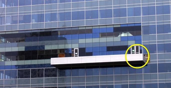
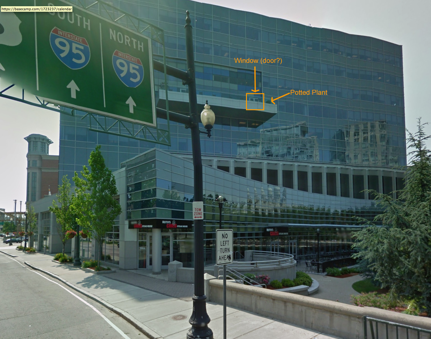
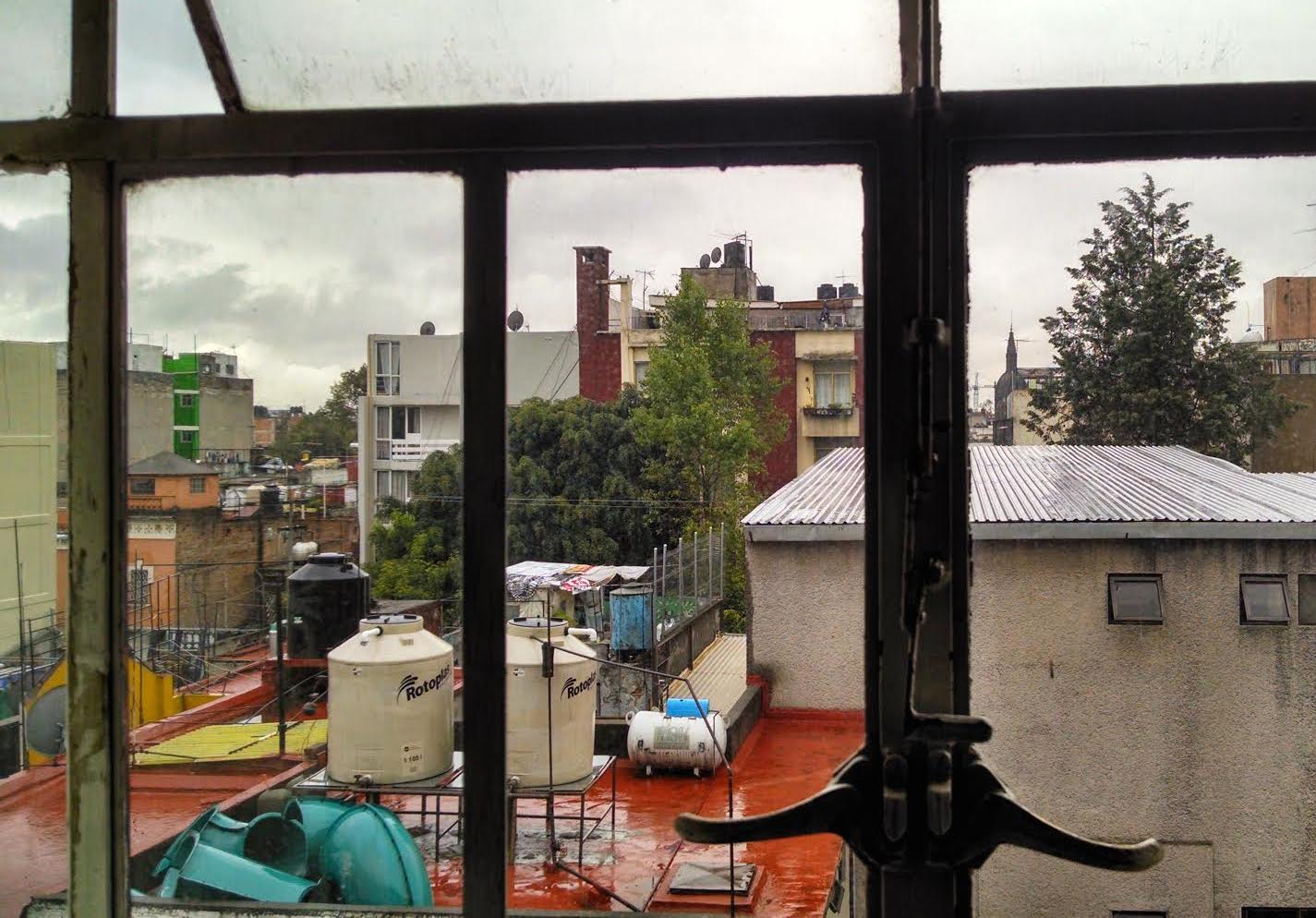
Man, that art history degree FINALLY paid off (well, enough to know where this photo was taken, the student loans are still a monthly burden. Mind you, I started paying them off in 1993.) I immediately recognized the steeple of the First Baptist Church in America in Providence, Rhode Island. It looks like the view is from the GTECH Corporation building. It’s that window off the corner of the balcony jutting out riiiiiight … THERE:
The balcony is located on the 7th floor and it’s used for “customer demonstrations and meeting rooms”. Beats my sad, windowless office for sure.

The architecture critics really came out of the woodwork this week:
Collectively, this photo is taken from and of several pieces of Modernist architectural banality that have stymied the civic momentum represented by the work done in Providence during the 1990s to revive downtown through traditional urban planning and architectural. These buildings, with the GTech building being the worst offender, represent the resurgence of the “avant garde” as they bravely resisted the civic pride that was being rediscovered, via PoMo blandness, Vancouver-ish soporifics, and good ol’ Dallas-Ft. Worth office park cheap’n’boring respectively. Fortunately, Providence still retains a great deal of its historic fabric from the late 1700s through the 1930s, so ugly junk like this is mostly the exception, not the rule.
Another:
The buildings look part of the mixed use redevelopment trend, but it also seems this is a tourist district. It’s nice enough, and almost certainly better than the old industrial complex that was probably there 50 years ago. But the architecture leaves me a little cold and I wish they had riffed a little more off the brick that dominates most New England downtowns. I’m not alone in the critique – found these quotes from an article about the design before the building went up:
“The structure has no place in Providence,” said Gregory Mallane. “It really belongs in an industrial park.”
“This building is completely out of place” in Providence, said Charles Pinning, a Providence property owner. “This building would be appropriate . . . in a city that has either obliterated its history or doesn’t have any.”
Another critic takes us to city planning school:
The Gtech building sabotaged what had been a really interesting experiment in architecture and urban design Providence had going for 20 years. A new take on urban renewal that would eventually emerge as a critique of the bomb-and-rebuild modern method of urban renewal that had marred cities from coast to coast. In the 1980s the federal, state, and city governments cooperated to bury the massive train yards between the State House and downtown, and to move and expose the two rivers that join to form the Providence River. In doing so, 80 acres of formerly industrial land right next to downtown were opened up for development.
It got interesting when regulations were drawn up to ensure that development here would feel complementary to the existing downtown. Above-ground parking was prohibited, and buildings had to built out to their lot lines, to create a consistent street wall and an urban rather than suburban feel. Further, a commission was appointed to enforce these regulations and to approve the design of individual buildings. This type of committee is certainly a potential nightmare for developers, but there was plenty of development and for a good while the commission worked surprisingly well. From 1988 to 2002 eight large buildings were built, among them a 30 story hotel tower and a 1.4 million square-foot shopping mall.
Initially the designs were postmodern but as years passed, shaped by the Commission, the designs became less postmodern and more unabashedly neo-historic, using traditional elements without irony or distance. Most architects and critics where lukewarm at best towards these buildings, but the public and vistors tended to love them. It was an intriguing experiment- what might an urban district built entirely anew at the turn of the 20th and 21st centuries look like without the reigning prohibition on designing in historic styles? At the intersection of Francis Street and Memorial Boulevard the experiment had achieved some real intensity, with the proximity of three buildings patterned and decorated to sharpen, rather than dull, the sense of scale of large buildings close together.
Then in 2004 the empty lot at the fourth corner of this intersection was filled by the Gtech building, a clunk of offices wrapped in a glass curtain wall that would have looked dated in 1965.
It somehow manages to feel insubstantial and leaden at the same time. The truncated corner tower is flat-topped because no one could come up with a satisfying modern minimal spire that didn’t look cheesy. It’s as graceful an amputation. The designers of this building either didn’t know how to or weren’t interested in respecting the very strong, albeit newly-created, context of this very prominent intersection, not to mention the downtown beyond. The building is twelve stories tall but thanks to its lack of lack of surface detail feels like half that. Whereas the surrounding buildings are romantic and exuberant, playing up the urban drama of congestion and vertical space with details that allow the eye to measure height to 30 stories, the Gtech building refutes all that with an obstinate blankness. It is as wrong for its site as if dragged in from a suburb of Atlanta or San Diego. (Both cities I like, by the way.)
Once Gtech went up the floodgates were opened and the rest of the capitol center filled up with modern somewhat minimalist buildings, which are visible in the window view. None are as bad as Gtech.
And back to the political angle of this week’s contest:
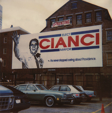
The scene is timely at the moment as we are in the midst of a pretty amazing Mayoral election that features Vincent A. “Buddy” Cianci trying to return to the office he has had to leave twice previously due to felony convictions. He was leading in the one publicly released polled and it will be amazing if Providence voters return him to office.
Many readers covered Cianci:
“Buddy” was mayor of Providence from 1974 to 1984. He was forced to leave office after
pleading no contest to an assault. He had allegedly taken a burning log from a fireplace and beaten a man whom he believed was having an affair with his wife. His wife’s name is Nancy Ann, which makes her full name Nancy Ann Cianci (say it out loud).
In 1990, he ran for mayor again. His slogan was that “Providence needs to be made love to again.” After he won, his particular form of romantic devotion was to have the dreadfully polluted Woonasquatucket River (one of the two branches of the Providence River) converted into “Riverwalk,” a series of paved bridges that is billed as “the widest bridge in the world” (on the theory that all the bridges that cross the river are part of a single bridge). He was sent to federal prison in 2002. He has served his time and will be on the ballot as a candidate for mayor in a few weeks.

So much more:
Since this is Providence, public corruption is never far away. WaterFire opened during Vincent “Buddy” Cianci’s second stint as mayor. And here’s a 1997 photo of Cianci in front of the redeveloped WaterPlace Park before he was arrested during Operation Plunder Dome, convicted of racketeering charges, and spent over five years in federal prison. (According to the Solicitor General, “the government presented evidence at trial that [Cianci] and his co-defendants awarded (or caused to be awarded) municipal jobs, city contracts, tax abatements, and building-code variances in return for cash (including contributions to Cianci’s campaign fund) and other items of value.”)
Not that a prison term should ever stop someone from a life in Rhode Island politics. Cianci is running for mayor again and, according to a recent poll, maintains a slip lead over his closest competitor.
Another provides some art history connected to Cianci:
I believe the viewer is looking in the direction of one of Shepard Fairey’s alleged first acts of political art; he was a RISD student in the ’90s. Then candidate Buddy Cianci’s face was super-imposed over a billboard advertising the Providence Zoo’s naked mole rat exhibition.
Actually, as this reader explains, Cianci was the original inspiration for Fairey’s “Obey” images:
An interesting bit of trivia: Behind the red triangular building, on the corner of N Main and Steeple
streets, was where Shepard Fairey began Obey Giant (or more specifically, it’s earlier incarnation of “Andre the Giant has a Posse”), which predates his famous HOPE posters for Obama. It was 1990, and convicted felon Buddy Cianci, was running for Mayor for a second time after being released from prison. He had a large campaign billboard at the foot of College Hill facing RISD, where Shep and I were both students. As part of a class assignment, Shep wheat-pasted Andre the Giant’s head over that of Cianci’s, scrawling the soon to be famous words “Andre the Giant Has a Posse” over Buddy’s reelection message.
Someone made a short film telling the story as well. Speaking of stories:
I got into a fight with my girlfriend in that little amphitheater on the left, so thanks for re-opening those wounds. At first I wasn’t sure which floor the balcony was on, so I called GTech and asked the security guy. It’s the 5th floor. (He was very confused so I told him I was planning an elaborate proposal for my girlfriend. Haha, he has no idea we already broke up.)
And a few readers have actually been to the GTech balcony in question, but only one has puked there:
Good lord do I remember this view. Late afternoon cocktail party that went on a bit too long. I found refuge and comfort on that balcony. Don’t want to mention the company’s name, if anyone there is reading this they’ll know who I am. I assure you the box fern in the pic is a replacement.
And finally, this week’s winner is a veteran of more than 20 contests:
Time to give the novice players a chance, huh? I imagine Chini got it before his coffee got cold. This week’s window actually looks to be a glass door, leading to the balcony on the 7th floor of the Gtech headquarters. The balcony overlooks picturesque Waterplace Park in Providence, Rhode Island:
I found the location by doing a Google images search for condo “random balconies”. The main building the view shows up about halfway down the first screen. Interestingly, putting “random balconies” in quotes was the key. Without the quotes, the building doesn’t show up at all. Makes me a little proud of my “Google Fu”.
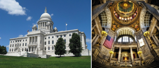
Not pictured is the gorgeous Rhode Island State House, just out of view to the left. In my opinion one of the most beautiful capitol buildings in the country, both inside and out:
Beautiful, and likely corrupt, it seems. As it turns out, this week’s view originated on a field trip:
As a regular incorrect guesser of the contest, I feel a bit bemused to have the photo chosen for the contest! We took URI’s full-time MBA students to visit GTECH’s North American HQ, located at 10 Memorial Blvd in Providence. I took this photo from the northeast corner of 7th floor of the building, which overlooks the Providence River. GTECH uses this balcony to host special events, and this window is the first window of that balcony. If anyone has attended a Waterfire event, they’ll know this spot.
Too bad I can’t enter a guess in the contest, because I’d nail it this week!
Instead we’ll see you for next week’s (more difficult) contest.


