The boundaries aren’t so clear:

Jenny Xie took this survey and posted the above maps, which aggregate the responses of everyone who took the survey:
[I]t appears Montana, Wyoming, Colorado, Kentucky, Arkansas, and Oklahoma are the states of most contention. I personally felt I had no choice but to cut some of them in half. Perhaps the correct answer is still the textbook answer: the states of most intensified yellow (at least as identified by those who’ve lived in the Midwest the longest) make up the U.S. Census Bureau’s definition of the Midwest: Illinois, Indiana, Michigan, Ohio and Wisconsin to the east, plus Iowa, Kansas, Minnesota, Missouri, Nebraska, North Dakota and South Dakota to the west. (As a commenter pointed out, cartographer and historian Bill Rankin has also done a Midwest mapping project, in which he overlaid 100 different maps of the Midwest and made the confounding observation that “no area … was included on every single map”.)
Ctd …

A reader writes:
This is an eternal argument, man. Is Oklahoma in the Midwest, or is it a Southern state, or maybe Southwestern? The answer is: it depends on what part of Oklahoma you’re talking about. Oklahoma is at a crossroads in this country, in a number of ways. If you’re from Ponca City, not far from Wichita, that’s pretty heavily Midwest. If you’re from Idabel, down in the southwestern corner, you probably have more in common with Louisianans than you do with Iowans. If you’re from Gage, out in the panhandle, you’re within spitting distance of New Mexico and Colorado. And folks down by Lake Texoma … well.
And it’s not just cultural; it’s geographic, as well. I was just the other day messing around with a map of North American biomes. To illustrate a point to a friend, I overlaid a US map with state outlines over this map [see above]. Sorry, my bastardized version is on my home computer, but I figure you can tell pretty clearly that the big crossroads right in the middle is, in fact, right in the middle of Oklahoma. There are, like, ten colors on the map that fall within the Oklahoma state line. So, yeah, we’re a little bit of everything; we can provide you with just about anything except for tundra and oceanfront property (to my everlasting sorrow).
Another reader:
My favorite definition of the Midwesterner: If you call a carbonated beverage pop or soda pop, you are from the Midwest. Hence, Pittsburgh is in the Midwest. Being about a 7+ hour drive from the Atlantic Ocean, Pittsburgh should not be called an East Coast city. A related definition: If you call all carbonated beverages Coke, you are from the South.
Another:
I’ll proffer the great Pop vs Soda map (the one by county is almost older than the Internet, but I think still the best). According to these maps, the dividing line between pop and soda country runs between Syracuse and Rochester. So Syracuse is in the east and Rochester in the Midwest. Of course, while it seems to get the outside boundaries pretty well (other than the western boundary), Saint Louis and eastern Wisconsin call fizzy drinks “sodas” unlike the rest of their midwestern brethren. Tulsa, which is in pretty-southern Oklahoma, must be midwestern (pop) while Indianapolis, in very-Midwestern Indiana, calls it Coke. So it must be in the South.
Ctd …
A reader writes:
Your reader says that Pittsburgh cannot count as an East Coast city because it is 7+ hours from the coast. Then please explain to me why it belongs in the same region as Chicago (8 hours from Pittsburgh); Des Moines, IA (12); Lincoln, NE (14); and Rapid City, SD (19). Granted, the distance from Wilmington, NC to Shreveport, LA is a solid 14 hours, and no one thinks that North Carolina and Louisiana are in wildly different regions. I just get riled because frequently people from the East Coast actually have no idea how huge this country is, and make flippant statements like “Pittsburgh is too far from the coast so lump it in with the flyovers.” America is vast, and contains multitudes. Explore!
Another reader:
I was born and raised in the Midwest and lived in various states for 40 years, and it never ceases to amaze me how people conflate anything that’s not East Coast as Midwest. While I love my East Coast brethren, they are profoundly ignorant of the geography of this country. Pittsburgh is about as Midwestern as San Francisco. Wyoming in the Midwest? Huh?
I have one very simple rule: if it’s in the
Eastern Standard Time Zone, it’s not Midwest. To extend it, there are only a few tiny portions in Mountain Time that are Midwestern. Broadly speaking, there are two basic parts of the Midwest: the Great Lakes region and the Great Plains region. They may look similar to someone sitting in DC or New York, but they are different culturally, topographically and politically. But the best map and definition that’s ever been written to date is still Joel Garreau’s Nine Nations of North America. Garreau really nailed the specific differences and demarcation points (though I would lobby for an additional “nation” that picks up the Scandinavian quality of the people in the Upper Midwest into Canada).
Another:
Here’s a definition from a born-and-raised Midwesterner who often drives to its outer reaches: Midwest = Germans + Grids + Gardens
Germans: On this map of ethnic ancestry from the 2000 census, there’s a broad swath of German-plurality counties starting from central New York, through Pennsylvania stretching westward to the Rockies and beyond. Germans help define the southern border of the Midwest (though stray Finnish, Dutch and African-American counties are certainly Midwestern as well). Germans heavily influenced Midwestern architecture, food, religion, and its devotion to public education. The “American” cultures of Kentucky and southern Missouri are southern – the accents change, Baptists predominate, and so does the food (it gets better down South, but that’s not Paula Deen’s doing). But not all German areas are Midwestern, so a limit to this is:
Grids. A central man-made feature of the Midwest is its grid pattern, which, thanks to the Land Ordinance of 1785 and Glaciation, stretches from south of Cleveland toward Cincinnati, and then west to the Rockies, defining the eastern and southern borders of the region. There are a few pockets where “queer” roads must follow the hills, such as around Bloomington, Indiana, or Athens, Ohio, or in the Ozarks. Those areas are on the fringes of the Midwest. Driving a Detroit-made sedan or pick-up truck down a straight state highway is a Midwestern rite of passage. So straight roads and flatlands (not Appalachian or Ozark zomias) help define the Midwest. This grid was made possible in part by Glaciation, which covered the land with very fertile soil. So the last characteristic is:
Gardens. (I couldn’t find a better synonym for farms that maintained the alliteration.) Anywhere that farming occurs on a wide scale and without irrigation is Midwestern, which defines the western border from about Joplin, Missouri, northward to Topeka, Lincoln continuing to just west of Fargo. Northern Michigan and Wisconsin are also peripherally Midwestern, and I suspect residents of those regions agree, though I can’t speak to northern Minnesota.
Putting this all together, Germans, Grids and Gardens means the Midwest begins in Downtown Cleveland, south to about Athens, Ohio, then west about Cape Girardeau, Missouri, with a bump up I-55 to St. Louis, and back down I-44 to Joplin, then north to Topeka, Lincoln, west of Fargo, to Canada.
Update from a reader:
Was that “born-and-raised Midwesterner” really suggesting that the defining characteristic of the Midwest is that it’s GGG?
Heh. One more reader:
There’s a historic line of demarcation that cuts right through some of the most contentious
states. The 100th meridian quite accurately separates the lower-lying, well-watered eastern half of the Great Plains from the high-country, arid western half. Rainfall drops from two feet to a foot at the meridian; altitude crosses from under to above 2000 feet. In the past, east of the 100th was lush tallgrass prairie; west, sunburned shortgrass. Today, in the east, Mother Nature does a lot of the irrigating; in the west, farmers pump the aquifers and cosset every drop of rain. East is dairy cows; west is steers raised for beef.
See where the U.S. highway system goes from a dense mesh to a loose net on this map? That’s the 100th meridian, and those roads speak volumes about the human population density on either side of it. Much has been written about the meridian – Wallace Stegner’s biography of John Wesley Powell is named for it, for example – and it remains meaningful to the regional culture today, as this 2011 article from the Pierre, South Dakota Capital Journal notes. I’d suggest that it’s what really divides the Midwest – a green and pleasant, neighbors-and-towns land – from the brown and solitary West.

Ctd …
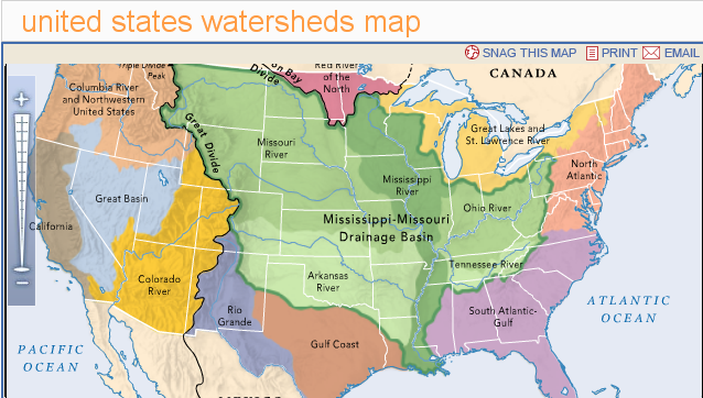
Another map from a reader:
It explains how Pittsburgh and Topeka are both sometimes “Midwest”. I think another factor, in addition to geology, climate, rainfall, and highways, is rivers and watersheds. Areas that share a watershed are connected physically by a river and have similar geology seem to form contiguous units.
Another writes:
Such a cool thread. And, being the reader who (I think) got the whole “South vs Social Mobility” thread rolling, I feel a compulsion to weigh in on the Midwest one. I’m not Midwestern, but I find the cultural boundaries of the US to be endlessly fascinating, since they don’t really hew to state lines, even though everyone expects them to do so. In particular, your reader who pointed out the 100th Meridian dividing line is pretty dead on (though I might move the Midwest/West boundary myself over to the west by about 150 miles). Think of all the things in “Midwestern” states that are so reminiscent of the West: Mount Rushmore; Teddy Roosevelt’s Badlands and its roaming bison; Dodge City, Kansas. Those are all, in fact, on the other side of the 100th meridian.
Also, perhaps the reason that Texas has such a self-centered identity complex is because it has no other singular region in which to identify. El Paso is solidly in the West. Houston is solidly in the South. Dallas, though it considers itself nominally “Southwestern” (how?), is really both Southern and Great Plains at once. And who knows what the hell San Antonio is – not Southern, not Western, not Midwestern. Hence, my theory is that Texas pride is so overbearing because Texans need to find they have something in common.
Another:
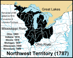
As is often the case in such matters, too many of your commenters have fallen into the trap of trying to logically, geometrically locate the “mid” of the West, rather than follow the historical evolution of the vernacular. The tipoff is that nobody in the South thinks of themselves as Midwesterners, no matter where they lie, East to West. That’s because the historical precursor to the idea of the Midwest is the old Northwest Territory, which led to the settlement of the northwestern corner of the United States. At least, what used to be the northwestern corner of the United States, that is, the Great Lakes region (more or less).
The Louisiana Purchase blew up that claim to fame pretty much right as the Northwestern
Territory was formalized, but rather than die, the idea simply evolved. The people of the old northwest knew that, politically speaking and population-wise, they were still “West” even if the (largely fictional) western boundary of the nation had vaulted far beyond them. They lived in the more-or-less-west, the kind-of-west, the really-not-as-East-as-it-looks-on-your-map, or as it finally came to be known (with a shrug inserted in place of a hyphen) the Midwest.
Later, with the further addition of the Oregon Territory, the “westerners” of the Louisiana Purchase, similarly bereft of their edge status, likewise laid claim to living in the Midwest. They, as any Ohioan (living in the first Midwestern state) knows, are mere pretenders to the throne.
Another:
I have to dispute your reader who was “born and raised in the Midwest”, who continued: “I have one very simple rule: if it’s in the Eastern Standard Time Zone, it’s not Midwest.” Try telling that to the residents of Dayton, Ohio (where I was born), where everybody identifies their region as the Midwest. This is nothing new – when I was young (circa 1960), our local TV station produced a weekly music show called Midwestern Hayride.
In fact, as the border zone, Ohio turns out to be much more complex and interesting than it usually gets credit for. Here’s how you should understand the three largest cities in Ohio, geographically, culturally, and politically: Cleveland is an Eastern city (old, industrial, ethnic); Columbus is a Midwestern city (mostly flat, sprawling, surrounded by cornfields, service-oriented, much more homogeneous demographically); Cincinnati is a Southern city (geographically and politically more like Kentucky than most of the rest of Ohio).
Another passes along the Onion’s take on the subject:
“The Midwestern Aborigines are ruddy, generally heavy-set folk, clad in plain, non-designer costumery,” Eldred said. “They tend to live in simple, one-story dwellings whose interiors are decorated with Hummels and ‘Bless This House’ needlepoint wall-hangings. And though coarse and unattractive, these simple people were rather friendly, offering us quaint native fare such as ‘hotdish’ and ‘casserole.’ … [T]heir mode of dress is largely restricted to sweatpants and sweatshirts, the women’s being adorned with hearts and teddy bears and the men’s with college-football insignias.
