A flummoxed reader:
Hell no. I … How … But … You know what? No. Just no.
Another took to heart last Wednesday’s MHB:
Based on the hinges of the window: Time Square Hilton. Room 420.
Or a remote island?
I’ve never been to Cape Verde, but this is definitely it.
A more qualified shot-in-the-dark:
You’re like a cat with prey – one week you give me a window that practically shouts its location from the rooftops, then today you give us this. No signs, no cars, no recognizable buildings. What are the clues? Desert-y mountains, a woman on a roof, a satellite dish (maybe?), the grate on the shutters. I was going to guess the Elqui Valley in Chile, only because I’ve been there and the mountains look a lot like the ones in the photo. But Chile is too prosperous, I think, to still have mud buildings. So I’m going with Huarpa, Peru, because the landscape is similar.
Bastards.
Or somewhere in Asia?
Unfortunately, I suspect it’s actually nearby to Jalalabad, but the relative paucity of photos means that’s about as close as I’m going to get. The mountainside combined with the lack of trees and the mud brick construction puts it somewhere around the Himalayas. The mud brick construction plus the funky window bars puts it square in Afghanistan somewhere. (Pakistan and Tajikistan tend to more modern construction.) For a largish city, Jalabad looks like the closet match to an area which has water (from a river), and enough moisture to grow trees on the hillsides and allow mud brick construction, but otherwise so dry that the high parts of the hills are just rock and sand.
Kabul is likely too flat and probably has better construction. And there’s an FOB in Jalalabad …
Another from that country:
Just a guess, but this feels like the Panjshir Valley to me. The topography screams Afghanistan (as I’m sure many of your military readers will agree). Given the condition of the road and the absence of any concertina wire or security barriers, I would assume the image comes from a relatively peaceful province. Moreover, the fertile valley in the background looks like somewhere in the eastern part of the country. It could also be Kunar, but my gut says Panjshir.
Or India?
OK, high mountains, south flank of the Himalayas, that is a pretty wide area. Not Muslim, judging by the colorful clothing, so scratch Srinagar and points West in the Karakoram and Hindu Kush. Probably taken by a Westerner in a small guest house or such, more likely to be found on Lonely Planet than TripAdvisor, so maybe an intrepid traveler or and MSFer on R&R. Plenty of such types in Ladakh, so should be close. Road looks paved and there are hints of large electricity pylons, so could be on the road to a hydro dam. So without checking every hydro plant from Srinagar to Thimphu I will settle on Alchi, Jammu and Kashmir, India.
Another is sure it’s Yemen:
I suppose it’s unfair that I immediately recognized this the moment I saw it, since I lived there for several years in the 1960s. This looks like Taizz used to look, before it exploded as a city. Since I see no terraced gardens in this picture, I assume it’s from the northern part of the country, not too far from the capital Sanaa, where the Houthis reign. This poor country has been devastated by the US’s drone strikes, along with so many other things reign.
Another nails the right country as well as the mountain range:
I’ll eat my shoe if this isn’t the Central High Atlas region of Morocco, near/in the Toubkal National Park (Jebel Toubkal is the highest mountain in north Africa). From the valley vantage point looking up into the snow-capped peaks, I’m going to guess the Berber village of Ouirgane, with many lovely old riads where one can stay while hiking in the mountains. This could be a view from the Dar Tassa, but I wouldn’t stake my life on it. I spent several wonderful years as a Peace Corps volunteer in Morocco, though my site was in the more heartbreakingly desolate Anti-Atlas mountains seen here.
Guesses were all over the map this week:
And a surprising number of readers knew the right country right away:
When I saw the photo I instantly knew it was Morocco. I visited Marrakech almost 15 years ago and I still have fond memories of that lovely country. I was traveling solo and spent a few days traveling in the Atlas mountains in a Land Rover full of Belgian women. We had an amazing time, seeing several casbahs, Ait Ben Haddou and bouncing down the high Atlas road to Ouarzazate (still my favorite place name ever). I need a good couscous and tagine now!
Another:
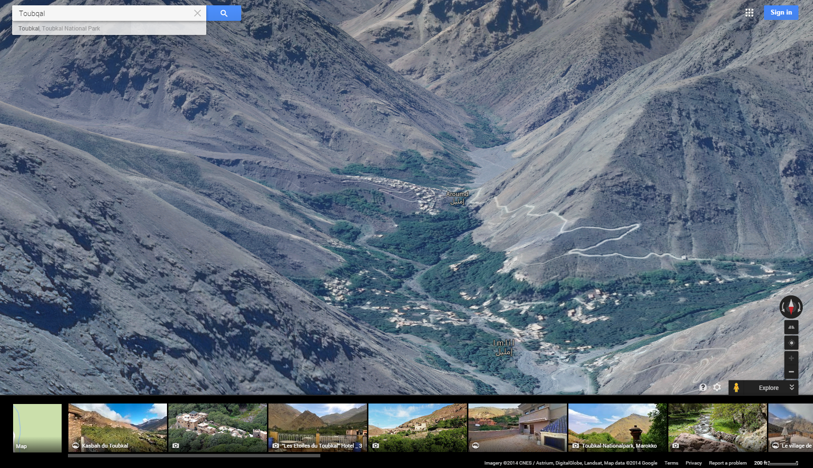
I was a Peace Corps volunteer in Morocco, and this looks like the High Atlas region of that country. I’d say the photo was taken near Mount Toubqal, the highest peak in Morocco. It looks like there is a small village between the window and the peak, and after poking around Google Maps for a little while, I’d say the photo was taken in Imlil, Morocco. I’m going to go one further and say that the patch of green in the foreground is Aroumd, Morocco. I’m not sure about this “Aroumd” place… In Google Maps, you will note that although the English says, “Aroumd,” the Arabic still says “Imlil.” Anyway, I’d say the best chance at capturing the view in the photo is on the West side of town, looking in the same direction as this Google Maps image:
I’ve been following your contest for a long time – too long to have any confidence of winning. Maybe I will at least make into your blog post as an “also-ran.” My parents would be so proud!
Another narrowed it down using a key clue:
The landscape screams one of four places – the Moroccan Atlas, the Zagros Mountains of western Iran, northern Yemen, or the Af-Pak borderlands. The seemingly unveiled woman is typical of the Berber people of the Atlas, so I’m going with Tafraoute, Morocco, a wonderful collection of villages south of Marrakesh. Where exactly amongst those villages this picture was taken, I have no idea – no doubt others will be more precise.
Bad luck found this guesser of Tacheddirt:
Sadists. You wait until I move house, to a diabolical cable modem that doesn’t work so I’m hopping around the attic trying to get 3G. That’s when you transport me to a place I think I know: hiking the wondrous trail to Tacheddirt, whose Wikitravel entry baldly states “The only way is by foot, no roads exist. The village isn’t very big anyway.” Whoever wrote that has no soul. Like me, moaning about modems instead of the disastrous floods that occasionally hit the High Atlas.
Well, I did find similar windows in the Gîte Iabassene further east of Tacheddirt (h/t salimr at summitpost.org) But instead of hurling my now-wheezing phone against the wall, I will leave it to your army of fenestrophiles to DNA the laundry on the nearby rooftop. Still, thanks for the memories of a magical place and the last time I had no internet for a week, though then it was willingly.
Incorrect guesses don’t get more specific than this one:
Aaack! One of those photos that you can probably only solve by having been there, but I’m taking a stab at it anyway.The window grill screams Morocco. The wide white window trim on the visible buildings plus the mud brick construction of the nearest building backs this up. The mountains, most likely the High Atlas chain. Currently very popular with the trekking set.
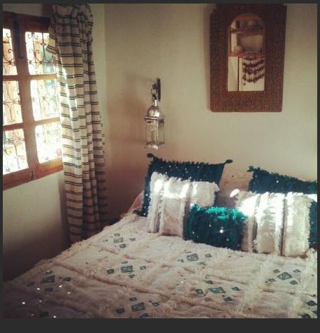
After a couple hours looking through the different hotel guest photos of the guesthouses and hotels in the valleys leading to the High Atlas from Marrakesh, I finally decided that this was taken from the Yan Room of the Douar Samra guesthouse. Why? Based entirely on the photo to the right, whose window grill matches the grill in the photo you posted. According to their website, this room is in the main house and has a balcony.
But it doesn’t seem to be taken from either of these, since the terraces below don’t show up, so it is probably taken from a side window. I’m guessing it is this window right here:
Looking forward to seeing how close (or far off) I was.
Not far at all. A former winner nails the village and lodge:
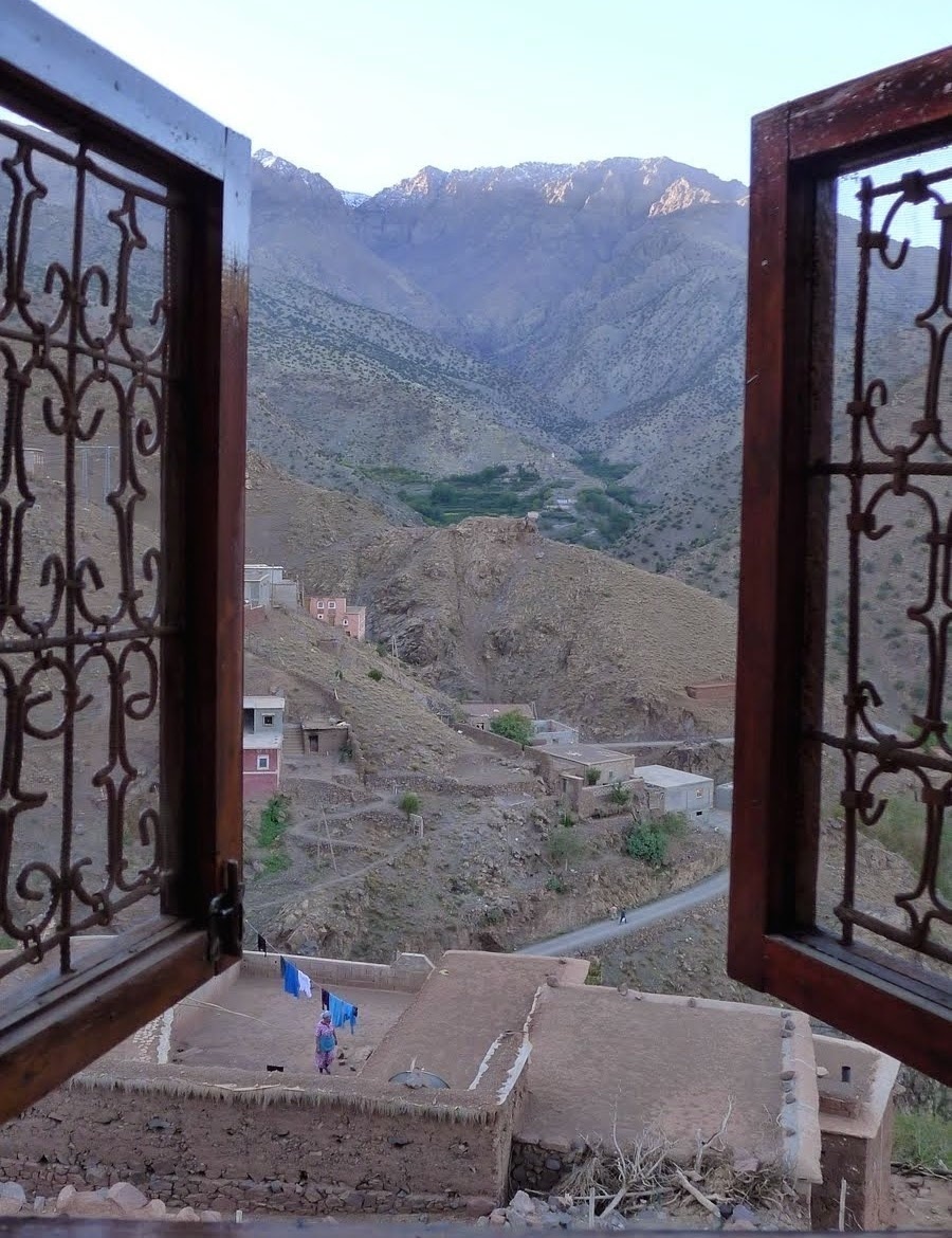
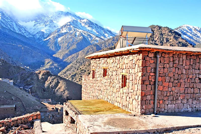
It looks rather tough, doesn’t it? But if you get a rough idea of where to look (a mountain region near the Sahara desert), and search for some distinctive feature (for me it was the peculiar power-line), it isn’t that hard to find, after all. This week’s picture was taken from the south side of the Azzaden Trekking Lodge, in the village of Aït Aïssa, Azzaden Valley, some 50 kilometers south of Marrakesh, Morocco. Here it is:
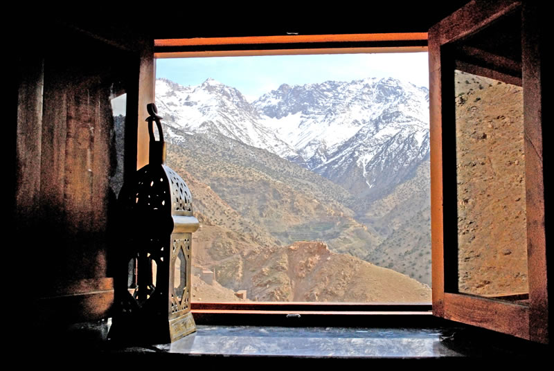
And here is the view from one of the rooms (maybe the same as this week’s picture?):
These more difficult contests really demonstrate how truly gifted some of our veterans have become. This one has been playing at Grand Champion level for a long time:
The contest view is from the southern façade of Azzaden Trekking Lodge (aka Toubkal Lodge) in the valley of Azzaden, Toubkal National Park, Morocco, and faces the Toubkal Massif of the Atlas Mountains. The lodge is affiliated with the Kasbah du Toubkal Hotel in Imili which is located in a neighboring valley and is more widely known. The scenery, villages, and wheat terraces of the area are ridiculously stunning.
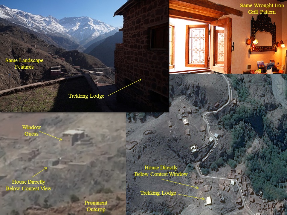
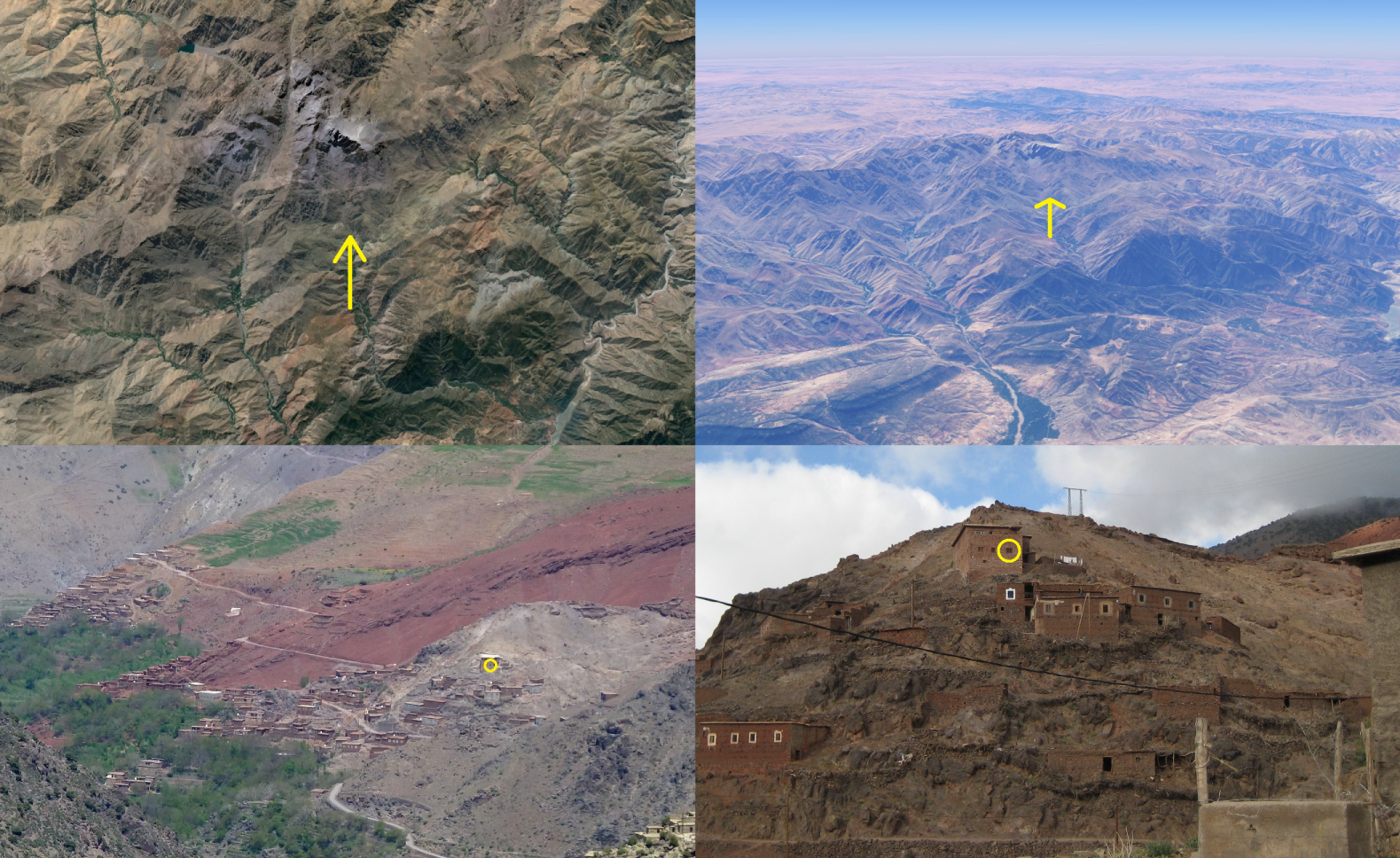
The construction and architecture of the earthen, stone, wooden, and grass house in the foreground of the contest view are fortunately quite distinct. Searches for earthen structures in Africa narrowed the possibilities to the higher altitude regions of Morocco and the northern Sahara and, from there, to the Toubkal National Park region. The prominent ridge outcrop in the contest window proved to be the clinching clue when I recognized it in an older photograph taken from the lodge’s terrace. Finding the lodge on Google Earth took longer given the scarcity of place names available for the area, but eventually the relative locations of the valleys, the mountain peaks, roads, and various structures fell into place.
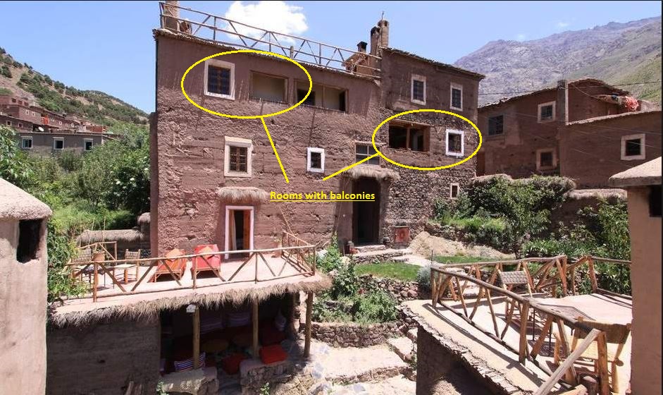
I am guessing that the contest window is one of three windows on the first (lower) floor of the lodge because the view appears lower than those in photographs taken from the second-story terrace (which is most of them). I decided to go with the western-most of the three because it seemed the one most likely to capture the contest photograph’s view of the western side of sprawling house directly below the lodge.
This search was a treat. Thank you.
Another:
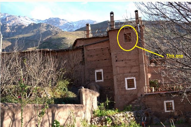
Great contest this week. The contest view comes comes from the Azzaden Trekking Lodge in the Azzaden Valley. The lodge is in the village of Aït Aïssa, Al Haouz Province, Morocco. No street address this week. Best guess on location is 31°08’02.3″N 7°58’28.7″W at 5950 ft in elevation. Jebel Toubkal, the highest peak in the Atlas Mountains, dominates the view out the window.
Online maps do not offer enough detail to determine the village’s name. The closest village they identify is Tizi Ouseem to the south of Aït Aïssa. A tour company offers this map that made it possible to discern the name by comparing the distances to, and following the valley paths from, Tizi Ouseem and Imlil.
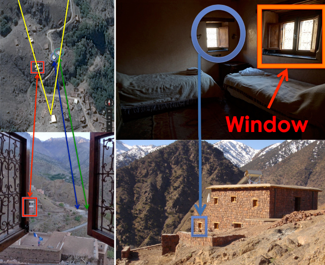
With Aït Aïssa pinpointed, it was time to find the gite or lodge with the contest window. The distinctive metal work on the windows (example here), the angle of the view towards Jebel Toubkal and the road below each offered great clues leading to the Azzaden Trekking Lodge. Attached is a comparison of the overhead view with the contest picture.
Once at the lodge, however, the exact window was hard to find. First, the window is on the south wall but I could only find exterior photos showing the east and north walls and the west wall. Second, the interior shots are difficult to make out and three sets of windows did not match. This window is too narrow and has the metalwork’s pattern on left and right panes reversed. This photograph shows almost the same view of the mountain but the window lacks metalwork. And these windows in the lodge’s southwest corner are also slightly off.
But this window looks just right. It is in the southeast corner below the top level terrace. Attached is a picture highlighting the contest window. It shows the room’s interior and where in the lodge it is based on a photo of the east wall:
Wow. Meanwhile, Chini tries to play coy:
I give up. I can’t find it. I’m resigned. Defeated. Shattered. I’ve looked everywhere, from one end of the internet to the other. Just when I thought I’d tracked an answer down, poof, it turns out to be something else. Think this image shows the building? No dice, Chini. That look like a good angle? Figured wrong, Butch. Sigh.
So I have to leave things where they are; I simply can’t find a good, close up image of the southern face of the Kasbah de Toubkal Trekking Lodge in Morocco’s Azzaden Valley where this week’s view was shot. The exact coordinates of 31° 8’2.47″N, 7°58’29.03″W in the village of Ait Aissa and these overhead and exterior views will have to suffice:
This week’s winners are a relatively new husband-and-wife team:
So my wife and I have come up with the location the past two weeks, and we were looking forward to this week’s View. And from the first moment I knew it just had to be Morocco, near the Atlas Mountains. So then I spent the next 3 or 4 hours looking at countless hotel websites, especially in and around Imlil. And then, finally, my wife found the shutters! At the Azzaden Trekking Lodge in the village of Aït Aïssa in the Azzaden Valle, a five or six hour trek from Imlil. The lodge is owned by – or associated with – the famous Kasbah du Toubkal in Imlil. The Lodge has three rooms, all of which appear to have similar shutters. I’ve decided that this room picture is the room with the View’s shutters:
Anyway, after four hours of searching – and as much as I enjoy it – it’s now way too late to continue this. Also, Obama is about to appear on the Colbert Report and I’m not going to miss that! So no more pretty pictures or Google maps with circles and arrows, But I did love this tour video of the trekking lodge:

Fantastic job. It was a honeymoon view:
As a frequent enjoyer of VFYW in contest and non-contest form, I thought I’d take a minute to submit this recent, especially fortunate view that I had from the Azzaden Trekking Lodge in the village of Ait Aissa, Morocco, in the Atlas Mountains near Mount Toubkal, the tallest mountain in North Africa. My wife and I spent our honeymoon in October travelling around Morocco, and we hiked from the town of Imlil, where many of the backpacking routes start and end, to Ait Aissa to get even more away from it all. We were there during the Feast of the Sacrifice, Eid al-Adha, where many people were back home for the holidays from Marrakesh and other cities and at night the sounds of singing and games echoed around the valley.
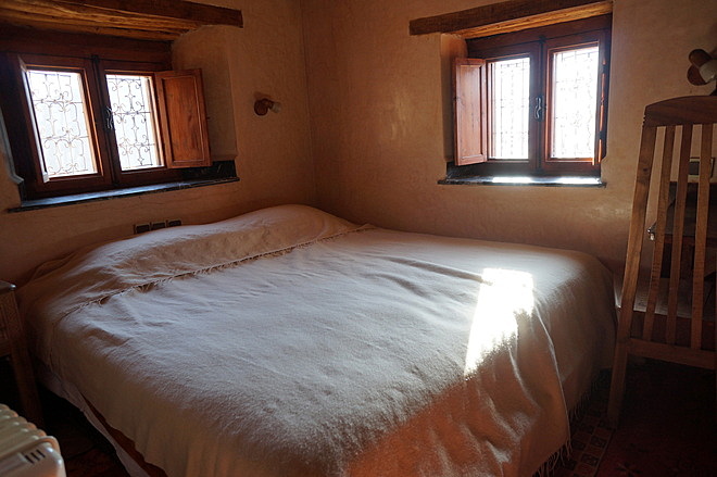
Here are a couple more shots, one from the terrace of the Azzaden lodge looking roughly in the same direction as the lodge, “up” the valley:
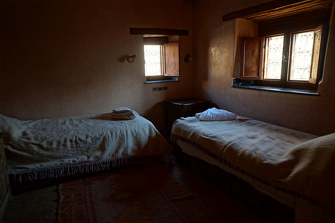
And another from the terrace looking across the valley to the village on the other side (sorry, don’t know the name of it):
Also, I would be remiss if I didn’t mention the friendliness and hospitality of all of the Berber people we came across during our stay in the Atlas mountains, in particular our trekking guide Ibrahim. His father and brother are also guides and so maybe someone reading the Dish will come across them one day! It was a real pleasure being there and I’d definitely recommend a visit.

For a Conde Nast Traveller write-up of the lodge, check out this PDF.
