You have until noon on Tuesday to guess it. City and/or state first, then country. Please put the location in the subject heading, along with any description within the email. If no one guesses the exact location, proximity counts. Be sure to email entries to contest@andrewsullivan.com. Winner gets a free The View From Your Window book or two free gift subscriptions to the Dish. Have at it.
Category: Contest
The View From Your Window Contest: Winner #178
A reader writes:
India again? That has to be somewhere in the south of India. The building in the center of the view is what all building and windows used to look like growing up. Everything around the building is new, especially the US-style concrete-and-glass building partially visible in the right. It most likely houses some BPO or software company. (Don’t tell me CGI…). I am going with Bangalore, specifically some part of old Bangalore, and not one of the burbs.
Another:
Harbin, China? It’s been in the news thanks to its “wonderful” air quality, and the slapdash-next-to-glitz atmosphere is spot-on for modern China. Plus, no external air conditioner condensers, so most likely a far northern city. Beijing, where I lived in 2001-2003, was full of them.
Another gets on the right continent:
Sticking with my preferred method of semi-informed guesses as opposed to hours of meticulous Internet research, this looks like Buenos Aires. At first glance I was in a different part of the world, but then the architectural details, tiled roof, temperate climate vegetation and possible Spanish sign on the building drew me towards a southern conclusion – maybe somewhere around Balvanera.
Another:
The word “Casa” appears on the side of the building to the right. Caracas was the first place in the Spanish-speaking world that popped into my head. And that was the best I could do this week …
Another:
Aargh, so tantalizing. This has to be Mexico City – the subtle giveaways include the green and orange colors of the walls, the windows, the clothesline, “Casa Something-or-Other” on the office building, and just the pleasing overall jumble. But where in the Distrito Federal is it exactly? Not spiffy enough for the Polanco, possibly shabby enough for Zona Rosa or Doctores. On a total hunch, I’m going to place this window across the Avenida de los Insurgentes Sur in the Colonia Roma. We’re near Avenida Álvaro Obregón. So let’s say Mexico City, Mexico, in the Roma neighborhood, somewhere on Guanajuato between Insurgentes and Monterrey.
On the other hand, the overcast sky suggests Lima, Peru. Still, I’m sticking with Mexico D.F. Can’t wait to see where this really is.
Commence kicking oneself:
This view is from the first floor (above ground floor) of the Hostal Buena Vista, at the corner of Schell and Grimaldo del Solar, in the Miralores district of Lima, Peru, looking NNW. The room has french doors leading to a balcony, from where the picture is taken. The low building with the clay tile roof and the building immediately behind it is the El Monarca hotel. The tall glass and concrete building in the background is the Casa Andina Private Collection Miraflores. I’m certain there will be many correct entries along with photos and maps since the Casa Andina name and logo are visible. Were it not for that, I would not even have attempted this window.
Right city, wrong hotel. Another reader:
I am guessing this photo was taken from the El Monarca hotel.
Nope. Another:
Here is is a panoramic photo from the opposite perspective, probably taken from the Casa Andina. The window from where the photo was taken is right in the middle of this photo:
Another:
I’ve never been to South America, but this picture was my idea of South America. I googled “Casa Andora South America” and got nowhere. So I squinted some more and tried “Casa Angina logo.” Do you mean “Casa Andina logo?” the Google asked me. And of course I did.
Another gets the right hotel:
The window from which my partner and I think the photo was taken is circled in yellow:
(There was some debate between us as to whether it was taken from the left-hand window or the right-hand one. I really hope I didn’t screw this up for us…)
Our first tip-off: The building in the background, with the sign for “Casa A*****”. After a bit of trial and error, figured out that the second word was “Casa Andina”, and from there, it was pretty quick work to find a hotel in that chain matching the photo:
Traveling a block south to figure out where the view from, my partner and I hit a bit of a snag: There are a lot of hotels densely packed into that block, and none of them had photos matching the view on TripAdvisor.com. (Sidenote: Why do so many people take photos of their hotel-room toilets, and so few take them of the views from their window?)
The big breakthrough: After trying for a while to figure out if the photo had been taken from El Monarca Hotel, I realized that the front of the hotel was actually *in* the VFYW photo, so the photo must’ve been taken from across the street. The identifying marks are marked in green:
That was when we realized that the green wall in the foreground is the other side of the red wall visible from the street. From there, it was a matter of trying to reverse-engineer the window. We’re pretty sure it’s one of the two windows visible across the street from El Monarca, but since there are a number of hotels clustered together there, we’re not 100% sure which hotel the window belongs to. We’re going to say that it’s a room in the Hotel La Castellana, but it could also belong to the Maria Angola Hotel and Convention Center, or to the Hostel Buena Vista.
Hotel La Castellana it is. Another reader:
The history of La Castellana goes back a century. It was originally a manor house constructed in
1912 and named after Grimaldo Del Solar, for whom the street is named. A vice-president of Chile lived there during his stay in Peru, it was owned by the German Association in Peru for a while, and then was a Bed and Breakfast. In 1980 its current owners purchased the property and spent two years converting it to the Hotel La Castellana, which was opened in 1982.
Out friend Google threw a few curves locating the proper building in Lima. Depending on how you approached the hotel chain listings, many times what turned out to be the correct location displayed a picture of a small, totally different building in street view. It took quite some time and a combination of Android-based Google Earth and Google Maps on the PC to sort things out with the modern building at the correct location. The search for the window was then possible.
Mercifully, both the Casa Andina building and the general location of the window were easy to recognize from the overhead views, as getting a useful street view involved a lot of hopping around. A key to the proper line of sight turned out to be the oddly forked tree on Schell Street. A street view from next to that tree showed pretty much the same line of sight to the Casa as this week’s picture.
Picking a winner this week was especially tough because the photo was sent to the Dish over four years ago. We had to go back that far in the archives because good candidates for the window contest are hard to find. The submitter writes:
Oh dear, you’ve sent me on a search through old itineraries because I can’t remember where I took the photo. And (20 minutes later) I can safely state that the photo was taken at: La Castellana Hotel, Grimaldo del Solar 222, Miraflores
I’m living in Metro Manila now. Perhaps I can take some photos to be featured on your blog around 2017.
Heh. Given that limited info, to determine the winner this week among the dozen or so Correct Guessers of previous difficult views, we counted the total number of contests they’ve participated in. The following winner has a total of 24 contest entries:
I imagine that when there’s text on a large building, you’ll end up with a lot of correct responses, but this one from Miraflores, Lima, Peru may prove tricky for everyone to determine the exact address. I’m pretty sure the photo was taken from the window circled in the photo, but I can’t quite tell which building it belongs to. I think it’s from La Castellana, a hotel, based on this photo from its interior on its TripAdvisor page, where the windows seem to match the ones in your photo.
One more reader:
I’ve taken a swing at these contests several times now, and been excruciating close on some of the more obscure views. Always off by a window or two, but here’s hoping this time will be different. And I’m including a gratuitous selfie just in case this comes down to a tiebreaker.
Woe to other contestants without beards!
Pogonophilic pandering gets you everywhere on the Dish.
(Archive)
The View From Your Window Contest
You have until noon on Tuesday to guess it. City and/or state first, then country. Please put the location in the subject heading, along with any description within the email. If no one guesses the exact location, proximity counts. Be sure to email entries to contest@andrewsullivan.com. Winner gets a free The View From Your Window book or two free gift subscriptions to the Dish. Have at it.
The View From Your Window Contest: Winner #177
A reader writes:
Hmmm. Mansard roofs, post-frost, Eastern-type mountains, deciduous forest. My gut tells me it’s somewhere in Quebec – that low, white building is typical of government buildings across Canada – and the New England towns I’ve been through are usually older in their admin infrastructure. The lack of a US flag anywhere also suggests north of the border; but if it is Quebec, where is the church spire? I’ll guesstimate it is somewhere north of Montreal in the Laurentians, trending east towards the Ottawa River.
Another:
I usually don’t play these contests, but the scenery looked so familiar that I had to try. It appears to be the Southern Appalachian Mountains. With the changing leaves (and photo probably taken several weeks ago), it seems like a higher elevation. Institutional building in background, a college or university. My guess is Boone, NC at Appalachian State University.
Another:
Overlooking the campus of Western Washington University. I don’t often enter, but I came close with the Vietnam entry sometime back. And while this picture could be in New England, for some reason I think it’s right up the road here in Washington.
Another:
Republic, Washington? I was there about this time last year digging fossils at the site of the Stone Rose Interpretive Center. It’s a beautiful little town. It also has a great brew pub.
Another:
This is too easy. It is the village of Karzakan in Bahrain. I was a Peace Corps volunteer near here. The mountain is Jabal ad Dukan with smoke from the riots from the oppressed Shia majority being put down by the minority Sunni led by the former Irish/American chief of police John Timoney.
Another:
Breaking Bad casts a long shadow (or I am just far too obsessed with it)! I learned from the show that New Hampshire is the Granite State. There seems to be a granite cliff beneath the road. The trees and mountains and style of houses also seemed right. The backs of those buildings behind the trees on the left could be the ones I found in a Google image search of towns in the White Mountains – they are in Plymouth, NH.
Another gets the right town:
I lived in Montpelier, Vermont for several years. And of course the photo is recent because of the fall colors. I would guess that you’re looking down on the town from a ridge to the ESE, but I need to walk the dog now. Maybe I’ll get a mention for an early response.
Another points to a notable fact:
I don’t have time to go running around Google Earth this weekend, but I got an immediate “Vermont” vibe from this photo, so I will randomly guess Montpelier, the smallest capital in the USA. Less than 10,000 people! Talk about small government.
Another reader:
The photo was taken from somewhere on North Street or possibly near the St Augustine cemetery. The first clue is the rock-slide repair near #8 Cliff Street. The second is the, let’s say “distinctive” white federal building on the lefthand side. The clincher is the cupola on the bank building at 110 Main Street. If I had to guess, I’d say closest to 179 North Street, but can’t say 100%. You can also see the top of the recently restored Washington Country Courthouse bell tower (red and white) in the lower left quadrant.
A visual entry:
Another:
I’m the reader who responded to your previous Vermont VFYW contest (Winooski) with comments about the power of Vermont’s sense of place. It’s now officially been 30 years for me in California, but the power of that sense of place has not faded. Upon looking at the photo, I immediately taken to Vermont, and after a few seconds of looking at topography and buildings, I recognized the city (I grew up about 10 miles away).
This is a photo of Montpelier, Vermont – the nation’s smallest state capital. The gold capitol dome is hidden by the hill on the right side of the photo, and the large (by Montpelier standards – five stories!) buildings in the distance line State Street. The real challenge here is figuring out where the photo was taken from. I can tell the general area and narrow the options down to a few streets, but Google street-view isn’t much help. Thus, I am left looking at a topographic map and guessing the street that this was taken from. I’m going to guess Ewing Street. Number 24 Ewing Street. However, the photo could certainly have been taken from Cross, Mechanic, or North Streets (or perhaps a few others I have not named).
It’s been lots of fun spending part of my day traveling the streets of Montpelier, if only remotely. This contest is always a great time.
Another nails the right address:
So the hard part for most people is the easy part for me. That is obviously a picture of Montpelier, VT, taken within the last few weeks. Lots of lovely old New England architecture in that shot but, for me, it’s the post office in the center left that really gives it away:
Of course, my wife’s from there, I was married there, and we spend half our holidays there (in Montpelier that is, not at the post office) so I have a bit of a leg up. The tricky part is determining which window that shot is taken from. You can see the buildings of State street on the right and the house on Cliff street in the center but the statehouse is obscured by the trees on Hubbard hill. So it’s looking out from somewhere in northeast Montpelier, near the St. Augustine cemetery.
I can’t quite find the spot that would have those houses in the foreground from that elevation with that vista. Too many trees for Google to help me much here. I’m going to take a flyer and say it’s from these apartments at 151 North St:
Fun facts: smallest state capitol (8,000 people, total!) and the most lawyers per capita of any city in the U.S. Unfortunately they also currently have the misfortune of running one of the least functional state healthcare exchanges.
151 North it is. Only one other reader got that address, and he breaks the tie by having participated in 12 total contests (compared to the previous reader’s 5):
This was a tough one. Didn’t take long to nail the town once I saw the post-peak fall foliage and the presence of a few large, office-style buildings in a downtown area meant that I didn’t spend hours searching through every sleepy mountain town on the east coast. No, the real issue was nailing down the right “window”. I have window in quotes because I’m pretty sure that this was taken from outside. The picture below shows my guess at a location, the parking lot of an apartment complex at 151 North St. From that location you can clearly see the gap in the trees from which it might have been taken.
From the submitter:
I noticed you ran my shot from the 14th for the VFYW contest today. I realized I didn’t give the address, since I didn’t know you’d use it for the contest: 151 North Street in Montpelier, Vermont. And I live on the second floor, which I’m sure some of your freaky-good window sleuths have figured out already.
Our VFYW grand champion is freaky-good:
You’d think that having gone to college an hour away from this week’s location it would have been a quick find for me, but it actually took a small search. That’s because I’ve only been to Montpelier once, and the only thing I remember, the capitol building’s golden dome, is hidden from view here by a hill. This week’s view looks west-south-west from the second floor of 151 North Street, a multi-unit apartment building. A best guess as to the correct apartment would be Unit #8:
Update from a reader:
How sad is it that I work out of Montpelier and I couldn’t get the window? I mean, the red line on the “visual submission” diagram misses my office (not just my building) by about 20 pixels. I guess some people just aren’t cut out for VFYW.
(Archive)
The View From Your Window Contest
You have until noon on Tuesday to guess it. City and/or state first, then country. Please put the location in the subject heading, along with any description within the email. If no one guesses the exact location, proximity counts. Be sure to email entries to contest@andrewsullivan.com. Winner gets a free The View From Your Window book or two free gift subscriptions to the Dish. Have at it.
The View From Your Window Contest: Winner #176
A reader writes:
The temple looks like something from Thailand or Cambodia, but since everyone will guess that I am going slightly further afield, to northern Borneo. Kuching, Malaysia? Total guess this week.
Another:
Manila, Philippines? That looks straight out of Apocalypse Now. I bet Kurtz is out there somewhere.
Another:
Mitt Romney’s deck from his secret condo at the Kali River Rapids ride, Animal Kingdom, Walt Disney World, Orlando, Florida. It includes a car elevator.
Who? Another gets the right island:
Somewhere in Bali. Best I can do this week; busy, busy. Spent a good part of Sunday afternoon touring Southeast Asia, but none of the architecture seemed to match. Temples in Bali looked like a perfect match, but in the “land of 10,000 temples,” I wasn’t able to nail down the right one.
Another tries to:
I haven’t submitted an entry recently and wanted to get back on the bandwagon. My bet is that you’ll get a lot of Bali guesses on this one, so I wanted to throw my hat in that ring. I’ve been to Bali a few times, so it seemed obvious to me, but I haven’t been able to pin the location down. This isn’t one of those really iconic spots on the island, so I’m going to guess at the Jagantha temple in Denpasar, Bali, Indonesia.
Another:
One of the more frustrating things about the VFYW contest is also its most fun: Every week I discover a million things that I didn’t know I didn’t know.
I was confident this was Thailand or maybe Cambodia. Browsing Google images, I assumed the architecture was Buddhist. But nothing looked quite right. At some point in my searching, I saw a building that looked very similar. Google’s header was “Hindu temple.” So, I don’t know if I should be ashamed of this or not but I had no idea that Hinduism spread that far south to the point of having so many shrines and temples. I was also struck to see how unique these Hindu structures in Bali were compared to those elsewhere in Indonesia.
I believe this week’s photo is a view of the Puri Saraswati temple in Ubud, Bali, Indonesia. If you use this image for reference, I think we’re looking at the left entryway, from a building behind the trees a bit to its right (our left). There’s a cafe there but this is an upper level and there’s a fabric curtain so I’m going to guess it’s one of the Puri Saraswati bungalows on site. I am having a helluva time finding a layout or picture of that corner and I’m hungry so that’s as far as I’m getting.
So anyway, thanks for the weekly lessons!
P.S. I just received the VFYW book from my Lviv win and while flipping through it spotted my submission from my parents’ living room. My dad is a longtime Dish reader, and the person who originally encouraged me to become one – I can’t wait to show him!
Another reader photo:
I started going through my photos of my Bali trip and stumbled on to photos of the same place that’s in your contest photo. The temple is conveniently right next to a Starbucks, where I was able to cool down in air conditioned comfort after trekking all over Ubud (a bit of relief after constantly saying “No, Thank You” to yelled offers of “Taxi, Madam?” from nearly every man I walked by!).
Another:
I’m looking forward to stories of aggressive Temple monkeys snatching glasses off a tourist’s face, pictures of manly men with bushy beards in sarongs at the Temple gates (required attire if you want to be respectful), and idyllic honeymoons spent in Losmen (guest houses) overlooking the temples and rice fields of this arty, scenic, and culturally diverse tourist destination. Although I’ll be prepared to be depressed by the faux authenticity of it all. Even on my first visit in 1984 this place was beginning to be overrun – they were just starting to realize the commercial possibilities of bussing tourists around to watch the spectacle of a Hindu cremation ceremony. By my next visit a decade later, the hot ticket was three-fer tours with a puppet show, a fire dance, and a cremation in a four-hour package.
Still a lovely place, with a population that lives its religion daily, and well worth a visit.
A visual entry:
More than 100 readers recognized the right temple, and close to a dozen guessed the exact room in the hotel, but the following reader guessed a difficult window in the past without winning, among a dozen total entries. So she’s the winner this week:
Pura Sarawiti Bungalows is the place. And it has some upstairs rooms, which is important, since the view is clearly from the second floor. And we are clearly looking at the roof of the bar and eating area on the blog. BUT … the room number. So I’m figuring I need to choose a random room number likely for the 2nd floor, but I find on Travelocity that the rooms have names, not numbers. Yudistira appears to be on the first floor, many of the rooms are on the street side (unfortunately for those guests), Arjuna gets mixed reviews, but is in back, Agung seems like a possibility. Gatotkaca has the most beautiful view and overlooks the water palace and dance performances. I’m going with that one (and guessing it’s the window on the far right in this picture. Nothing is above it, and to the right is an outdoor area.) If I needed back up names, I’d say Agung and Arjuna are the other possibilities, but I’m going with Gatotkaca.
From the submitter:
The hotel is the Puri Saraswati Bungalows right in the center of Ubud, about 30 meters east of the Museum Puri Lukisan where the exhibition I’ve curated is running. (By the way, puri means palace and pura means temple.) All the rooms are named for Mahabharata heroes. The photo was shot looking north from the easternmost window of Gatot Kaca, the second floor room of the bungalow that also has Yudistira on the ground floor. The gate is the side entrance to the Pura Taman Saraswati in the southwest corner. Saraswati is the god of science, culture, education, literature, arts and music. She’s a busy lady in Bali.
(Archive)
The View From Your Window Contest
You have until noon on Tuesday to guess it. City and/or state first, then country. Please put the location in the subject heading, along with any description within the email. If no one guesses the exact location, proximity counts. Be sure to email entries to contest@andrewsullivan.com. Winner gets a free The View From Your Window book or two free gift subscriptions to the Dish. Have at it.
The View From Your Window Contest: Winner #175
A reader writes:
Mediterranean I suppose, and I’m going to lay a marker down that those are terraced almond trees cut into the hillside. That peak in the background is probably some famous hill and the reason the pic was taken. But wait a minute – I call Shenanigans! This is the View from your Window Contest, and the goal has always ultimately been to find the window. But this week’s view is clearly shot from a vehicle pulled over to the side of the road. The barricade gives it away, as does the sloped angle of the shotgun window.
Finding good photos for the contest – interesting locations that are not too easy but not too challening – is much more difficult than you would imagine, so we have to bend the usual parameters for the contest sometimes. Another reader:
This one is quite problematic. The terrain and the fortified structure on the hill suggest Israel. The window, however, seems to be an automobile window, so its location is up for debate. My guess, the passenger window of a 2012 Honda Pilot, blue:
Another:
Route 66, 12 miles west of Kingmam, Arizona, shot from a 2010 Toyota Camry SE with leather trim and the six-speaker Infinity sound system, but no sunroof.
Another:
This is a view out into the Arizona high country from Paolo Soleri’s “urban laboratory,” Arcosanti. The poured cement, with a very un-laboratory-like railing, and the view into the valley just look very familiar from my visits there. Arcosanti is a mind-trip: Soleri imagined that thousands would flock to what we would now call a low-impact commune and re-imagine what a city would be. No one showed up, and now 65 or so people live there. The place supports itself by the very capitalist project of selling bronze bells.
Another:
Not much to go on other than flora and landscape! With all the talk about Breaking Bad, I was tempted to go for the Southwestern US – that hilltop compound would be an ideal meth-lord stronghold. But, I seemed to recall from geography that Southern Italy was once well known for terraced farming, which those giant “steps” in the hillside look like. And a Google search told me that the Ragusa region is also well known for the limestone walls the farmers built after excavating the land.
Another:
My first impression is Andalucia, Spain, based on it looking dry, with olive trees and pine trees, and scrub brush, and pastel buildings in square shapes that remind me of Moorish architecture. But mostly because there was a British TV show on PBS last night called Rosemary and Thyme, about two female gardeners who solve murders, and the episode was set in Andalucia and it looked just like this photo.
Another:
It could be anywhere in Spain (or, for that matter, half a dozen other Mediterranean countries), so I’ll hedge my bets and put the marker rather centric – the mounts of Toledo, Spain. To pointlessly narrow it down, let’s say road CM-403 south of Las Ventas con Peña Aguilera, Spain (my grandfather’s birthplace).
Another:
Somewhere in northern Jordan? Or perhaps it’s the site of the fictional “Deressa” from the French-Canadian film Incendies.
Another:
I got this!
I probably don’t really have this at all. I suck at this contest. But this looks to me a heck of a lot like the island of Cyprus where I had, a couple years ago, the best vacation of my life. Just a wonderful place, that island. But I remember this is how it looks in the winter out in the countryside – out in the patch of sort of rolling mountains between the resort city of Paphos on the western coast heading up towards the lesser resort city of Polis on the north coast. You can rent out little houses in villages out there, most of the time way cheaper than you could get a hotel room in the city. Really a cool experience, seeing the villagers wake up in the morning, go out hunting, go to church, go shout at each other in the street because they’re still hung over from the night before. God help you though if you get lost.
But anyway, the scrubby, Mediterranean trees look right to me. So does the way the hills are terraced for little fruit groves. The road switch backs look right because the roads there are so windy you can barely go more than twenty miles an hour. Even the way the valley sprawls out with the villages clinging to the tops of hills. Even the beige color of that building on the right and its pink wall and its water tank on the roof. All says Cyprus to me. All makes me want to go back.
Specifically what town? BAH! How should I know? They’re all pretty much the same and I need to go to the gym and this person I don’t think is even in a house! Standing on the side of some road! Window of their car! THEIR CAR! That’s not how this works!
Still, I’m going to guess though. Like stab in the dark guess. I’m going to say they’re on this switchback by this itty-bitty village called Melamiou looking back towards the more substantial village of Polemoi. Mostly I’m picking that because that’s near where I stayed when I was out there and the switchback looks right.
Another:
Looks like a rain collector on the roof of the building and the architecture seems to be familiar drab design one sees a lot in Israel. Mountainous and rocky terrain seem like the Golan region.
Another:
We’re doing car windows now? Really? This could bring it to a new level of insane.
So my instinct was Spain, but after puttering around the south for awhile, my boyfriend pointed out that the guards on the side of the road are different. I quickly jumped to the other country it reminded me of, Israel, and found that those guards fit better. That is where it ends however, because rolling dry hills describes way too much of Israel. I’m going with somewhere just outside of the south of Jerusalem, just because the north is more green and Jerusalem seems like a likely candidate for a Dish reader to visit.
Having already won once, the pressure is off and I find I’m enjoying the contest more. Best of luck to the winner!
Another:
Hilly country, terraced slope with olive trees, dry but not arid – Northern Israel or the West Bank would be my guess, not that I’ve ever been there.
West Bank it is. Another:
The terraced hills and the green-brown landscape remind me of the stretch of the West Bank between Ramallah and Nablus. That windy highway and cinderblock architecture could be on any small-to-medium Jewish settlement in the Judean Hills, so after a quick browse on Google Images I’ve settled on Givat HaRoeh. With my luck, this’ll be Tuscany.
Another settles on the right location:
I’m really annoyed that I can’t get this one exactly. I was sure I was looking south at the mountains that slope down from Amman to the Jordan Valley and Dead Sea. But after scouring Jordanian mountains for a couple of hours I finally realized that if we are indeed in the hills above the Jordan Valley, we can’t be on the East Bank because the satellite dish on top of the house at right would be facing the wrong direction. So, assuming I’m right about this being somewhere in the Jordan Valley, we must be in the West Bank. I’m too pissed to keep looking, though, so I’ll just say Nablus because it’s plausible. Could be Syria, I guess, Turkey, Cambodia? Dunno. I’m sicking with Nablus.
Nablus it is. But the winner this week is much more detailed and has participated in more contests, thus breaking the tie:
Wow! This seemed to be one of those epically hard views that you throw at us every once in a while, so I’m pretty surprised to have stumbled on the answer. Between the terrain and the olive trees, I figured this was somewhere in the Mediterranean. Wikipedia gave me the world’s top olive-producing countries and I did image searches for the first few, dismissing places like Algeria and Tunisia and thinking Greece seemed close but not quite right. I thought this could be Israel, but Israel wasn’t on Wikipedia’s list. Palestine was on there, though, so I moved in that direction. Searching “Palestine valley town” in Google Images led me to an article featuring a picture of rocky hills and shrubbery that looked pretty similar to the view in question. The article mentioned “the Salfit area of the West Bank,” so I narrowed my search and found another picture/article combo that mentioned “Salim” and “Nablus.” Even though I felt I was close, you can imagine my surprise when a search for “Nablus valley” turned up this particular shot:
Remarkably, this is NOT the image from the contest … but it’s the exact same view! The caption on this photo, which was posted on the blog of a Fellow with the Kiva organization, reads, “Road to Nablus, north of Ramallah.” I Google’d the route between those two and hoped it would be an easy trot to the precise location, but several hours inspecting the main route yielded nothing. I finally decided to try one of Google’s alternate driving routes and, within a couple minutes, I came across this GPS-marked photo, which clearly shows the same pink/grey building displayed on the right side of the contest image:
The VFYW image itself was taken on Highway 60, about 3/4 km up the road from the Tapuach Junction, where Highway 60 meets Highway 505. In the distance of the contest photo is the Palestinian town of Huwara (alternate spelling: Hawara). Obviously there’s no address since this was taken from the road, but the coordinates are approximately 32°7’18.55″N, 35°15’21.53″E. Here’s an overhead view which shows the bend in the road and the terraced hillside on which the olive trees are planted, as well as the view over the white buildings and that distinctive tuft of trees atop the hill in the very center of the photo:
Thanks, as always, for hosting this contest!
Thanks for the epic entry. Speaking of which, our grand champion nailed the right location yet again:
See, on Friday I was trying to get to Boston for a college friend’s housewarming (randomly, he’s one of the writers of League of Denial, the NFL/concussion documentary you’ve been discussing). Unfortunately, half of New York decided to book every train, plane and bus three days in advance and I didn’t make it up there. But the upside was a mostly free Saturday to work on the contest. So, off to the Holy Land I went.
And this week’s view comes from … Highway 60 near Huwara in the West Bank? I’m glad the rule against car views isn’t in effect for the contests, because this was a nice challenge. Though I’ve never been there, finding the right country was relatively easy, but tracking down the exact spot took some analysis and a bit of elbow grease. The view looks north by northeast towards the town of Huwara at center left, and the hilltop settlement of Bracha in the distance. For the die hards the exact coordinates are: 32°7’19.08″N, 35°15’21.01″E.
Here’s an image from a few hundred meters farther back on the same road with the viewer’s position marked just out of sight on the left:
(Archive)
The View From Your Window Contest
You have until noon on Tuesday to guess it. City and/or state first, then country. Please put the location in the subject heading, along with any description within the email. If no one guesses the exact location, proximity counts. Be sure to email entries to contest@andrewsullivan.com. Winner gets a free The View From Your Window book or two free gift subscriptions to the Dish. Have at it.
The View From Your Window Contest: Winner #174
A reader writes:
Based on the types of cars in the parking lot and the shape of the license plates, it’s got to be the US. And I’m just taking a wild guess here, but the proximity of the railroad tracks simply reminds me of a business trip I took a few decades ago to Cedar Rapids, Iowa. The city had a large cereal plant in the center of town and you could always tell from the smell, which breakfast cereal they were making, so we renamed Cedar Rapids – whose slogan is “the City of Five Seasons” – the City of Five Smells.
Another:
Hensall, Ontario, Canada? Sure looks like Canadian license plates; train tracks seem like the town of Hensall. I was there many years ago. They had a grain silo in town.
Another:
Battle Creek, MI? As a native Michigander, I recognize the landscape of trees and shrubs. Additionally, Battle Creek is along the railway with numerous small factories nearby. (Battle Creek is home to Kellogg’s Cereal and the trains come through frequently). Also, notice how the cars don’t have front plates? It’s not required in Michigan.
Another:
This VFYW contest is hard. I think I make out both Florida and Georgia license plates. Neither state requires front license plates. I’ll choose Valdosta, GA because Valdosta has railroad tracks. And cars. And sun. That’s the best a parent of two small children can do at this time.
Another:
No idea. I was going to ask my brother-in-law (who works in law enforcement) as a favor to run the personal information off the two clearly visible plates. I figure “Cowgirl” would be thrilled to have a random dude call her to see if I could get her e-mail address, send her a picture of her car I got on a public website, and have her tell me where exactly she parked. Instead I decided not to risk the offer of tagging along on a meth lab raid next time my brother-in-law gets the opportunity.
Another gets on the right track:
I am thinking that this outside a major city of Georgia based on the GA license plates that on the cars in the lot. Too bad I can’t run them without paying. I am also thinking that this place is near a Walking Dead film site. (The show premiers October 31, as usual.) Did you know there’s a WD Google Map?
In fact there a several, and they were WAY too detailed for me to spend time looking for nondescript buildings. I’ll choose Grantville because it’s one of the main sites for filming, but I can’t spot dual train tracks near there.
Another:
That is small town Georgia, for sure. Somewhere along the CSX line. One is right behind our home. Let’s see, Lee county is using PH in its tag sequence. Your submitter shows a PIA, so must be in Southern, or SW GA. The county name is large, so a few guesses there. I have seen a couple of readers from Tifton and from Tallahassee, so must be from somewhere around there.
Another quotes one of our grand champions:
What are the most common red herrings?
Mike: License plates.
There are so many, and they change so quickly. It’s easy to look at a plate and think you know where it’s from (or even to look it up on a license plate site), only to discover that it hasn’t been used for years, or even worse, that the same design is used in myriad countries or states.
But I’m no expert and the license plates are all I got here. I followed the red herring to a license plate site. These look like Georgia, which, according to the possibly-outdated plate site, also does not use front plates. I say this is Georgia. I have no idea where in Georgia so I’m saying Atlanta. Some very specific window in Atlanta.
Another:
I’m pretty sure at least three of those license plates are from Georgia. And it certainly looks like Georgia, specifically one of the towns centered along the railroads radiating from Atlanta (I should know, since I grew up in one of them). In other words, one of about a hundred towns in the northern half of the state that look more or less exactly alike. Aw, what the hell …
Another:
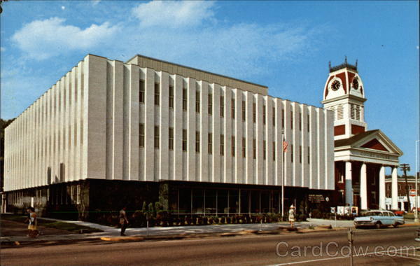
This one was ridiculously difficult. I could narrow it down to the state of my birth, Georgia, because most of the cars have Georgia plates and it looks like a typical small Georgia town. The presence of the Range Rover from Florida made me think it’s in South Georgia near the Florida line, except the hill with the large red brick building threw me. South Georgia isn’t very hilly. It’s impossible to read the name of the business in the building with the red facade, and all I can make out about the billboard to the far left is the word “Pain,” which this contest certainly is.
So, for no good reason I’m going with Tifton, Georgia because Tifton is a small town and I’ve decided that the red building on the hill is part of Abraham Baldwin Agricultural College, otherwise known as ABAC. It’s located at 119 Love Ave. It’s in need of a paint job, but establishments like those are struggling these days, especially in small towns.
Another:
I got Georgia from the license plates and Calhoun because it came back in the first page of search results for both “cement plant Georgia” and “Oxycodone Georgia” (note billboard with the word “PAIN” in the background).
On the other hand, “The sign advertising pain (bread) and the cars point me to the province of Quebec.” Another reader:
I’ve viewed every cement depot in Georgia (number plates) that is within a mile of a railway line, going over the same ones twice if they were within 50 miles of a KIA dealership and 10 miles of a McDonald’s, and short of making enquiries of the DMV, I’m completely out. I’ll go with College Park, Georgia, although it could have been any number of towns. Would love to know *how* the pro-bowl VFYW players get this one.
Another gets this one:
I thought this week’s contest would be easy because of the Georgia license plates on the cars and railroad tracks. Well, it turns out that there are lots of railroad tracks in Georgia to search and the contest took longer than I thought it would. But I have the time. I’m furloughed.
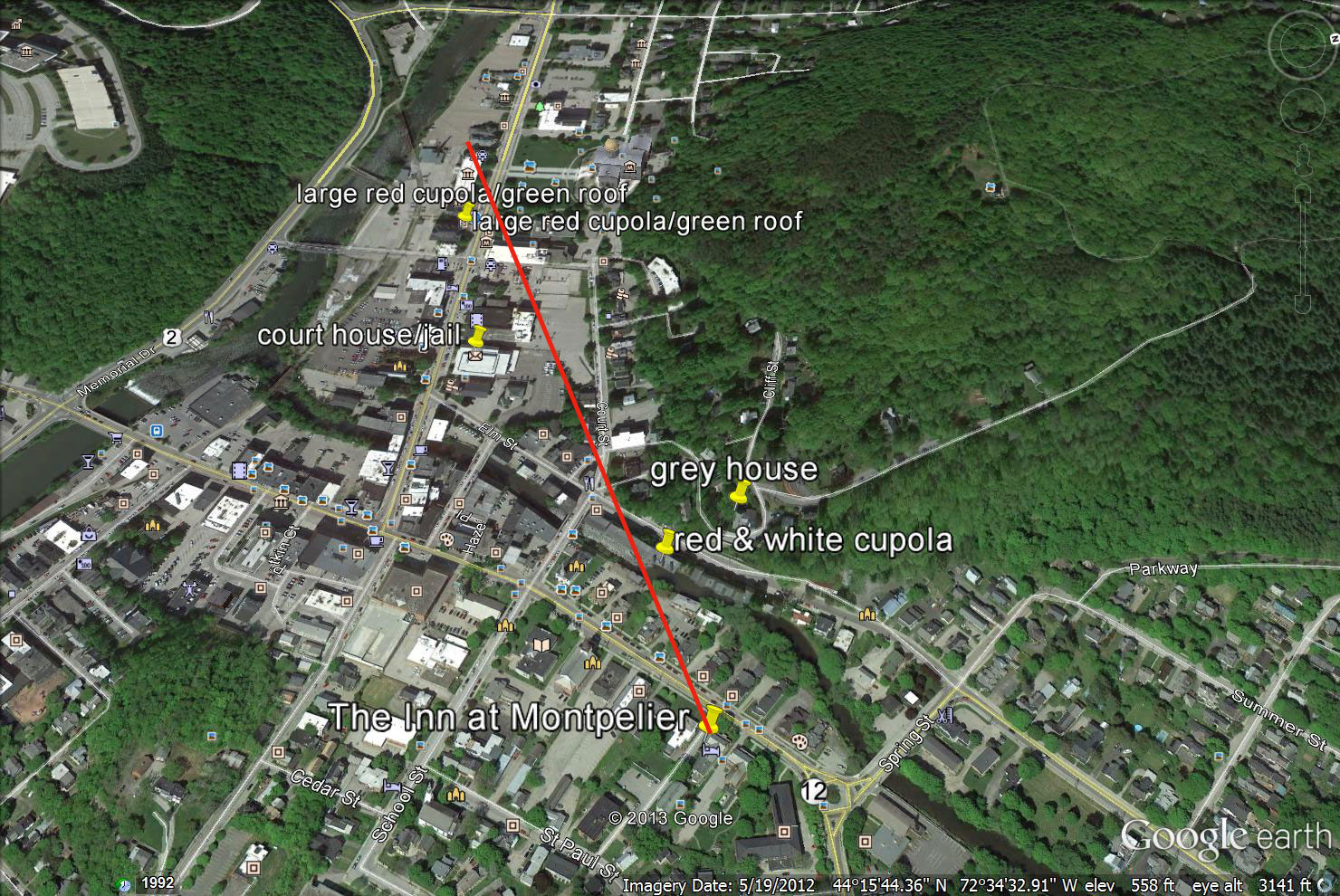
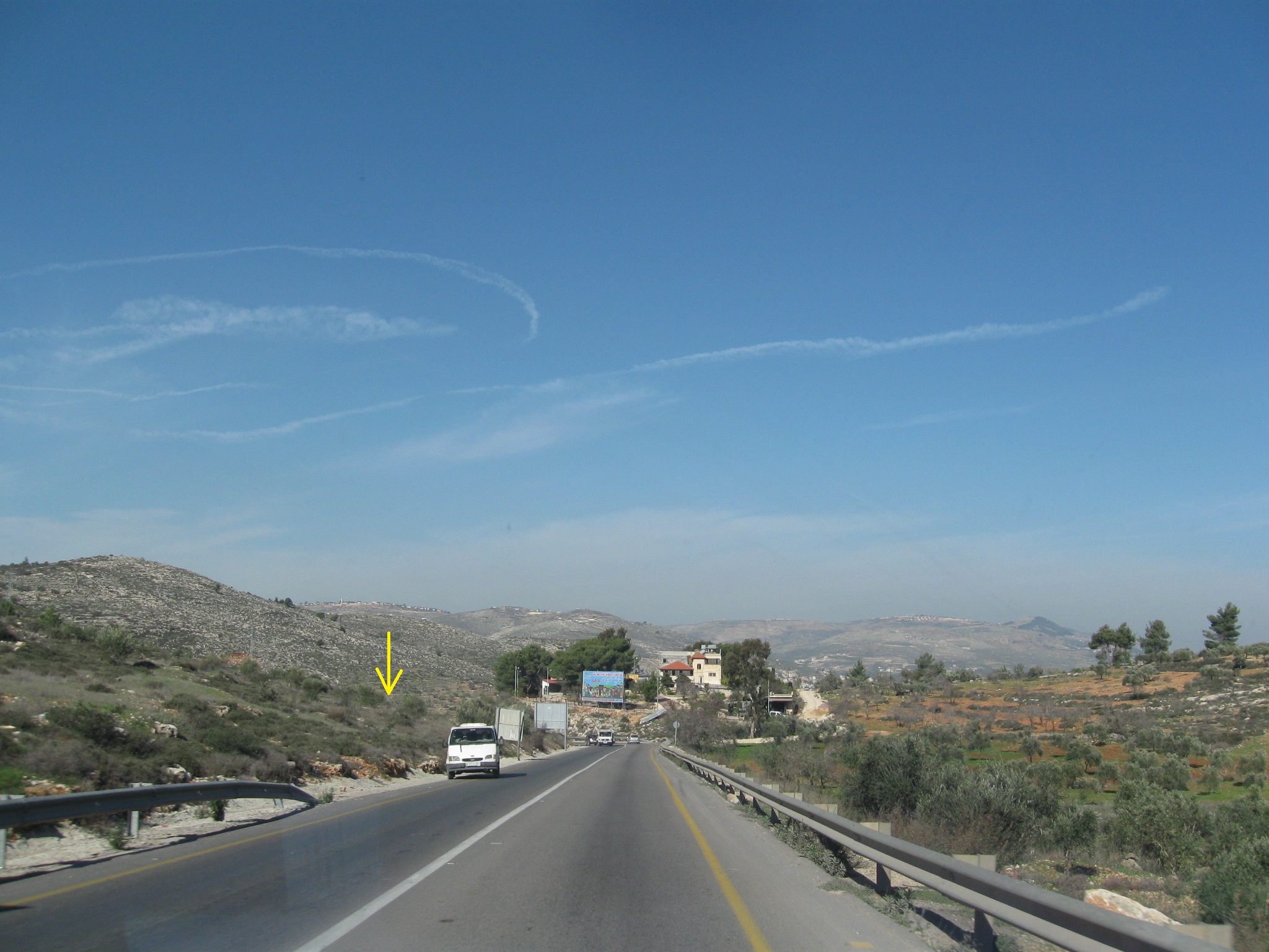
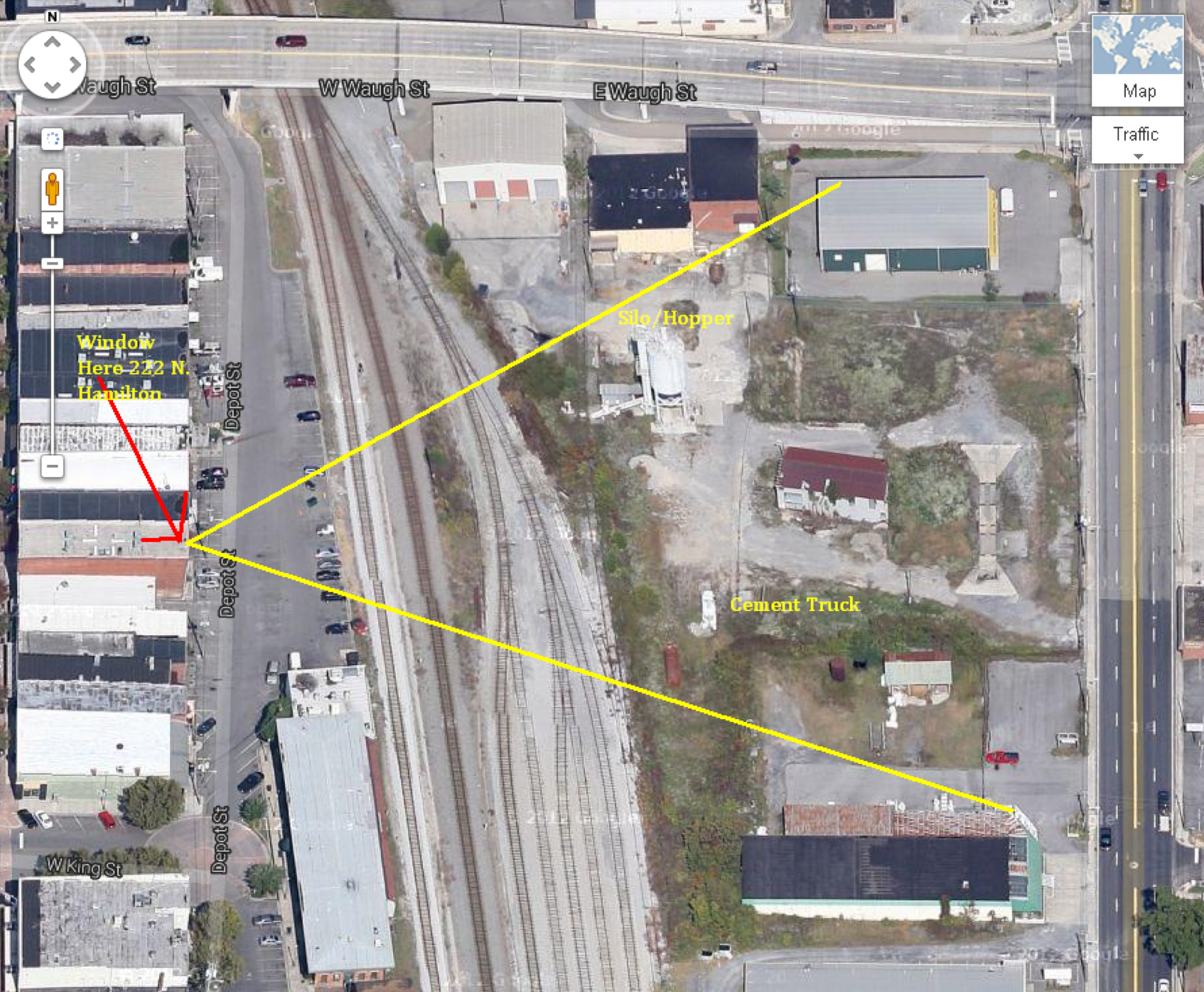
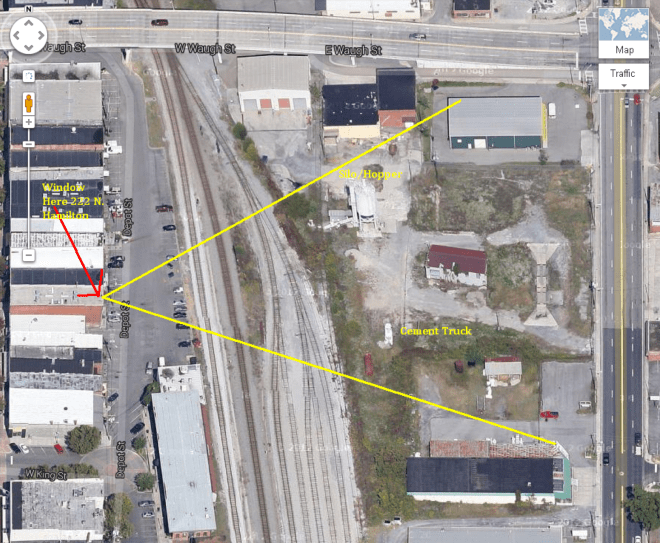
This week’s photo was snapped in Dalton, Georgia. The window could be in one of several neighboring brick buildings in downtown Dalton to the west of the railroad tracks. I think the window is most likely in the upper floor at the rear of 222 North Hamilton St.
Another notes the place of business:
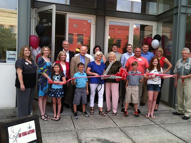
That’s 3 Divas in the Attic, and I even creeped a photo of their building off their Facebook page to verify their address. It’s of their ribbon-cutting earlier this summer, the submitter is probably even pictured in this photo:
Internet, you scary.
Another:
As a long-time reader, subscriber and lurker on the VFYW pages, I am happy to jump in this week. I believe that the picture is taken from the back of the 3 Divas in the Attic interior design shop in Dalton, Georgia. Exact address is 222 N Hamilton St Dalton, GA 30720. I believe that it is taken from the 2nd floor middle rear window.
One other thing: I have been meaning to write to you about After Tiller. It is kind of an amazing feeling to have two disparate parts of ones life come together. My partner and I did the post-production sound for the documentary. It is a project that we have loved and championed in our own tiny way. I can remember talking to Lana and Martha when we mixed the film and hearing their disbelief that the film would get into Sundance or have much of a life. So, as an avid reader of the Dish and Andrew’s writing, I was so happy to see Martha and Lana on the Dish. After Tiller really is a special and wonderful film.
Another:
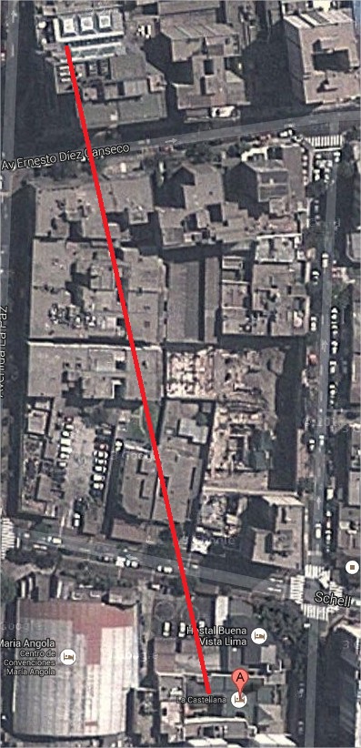
This is one of those weeks where random knowledge comes to the rescue. I spent much of my early search near Georgia’s major cities but I wasn’t finding much. Then, while focusing on the railroad tracks, I remembered that during the Civil War there was a major rail line between Chattanooga and Atlanta which became the central axis of Sherman’s march. A quick look at the state’s northwest corner not only found the rail line, but our location as well: the 2nd floor of 222 N. Hamilton Ave.
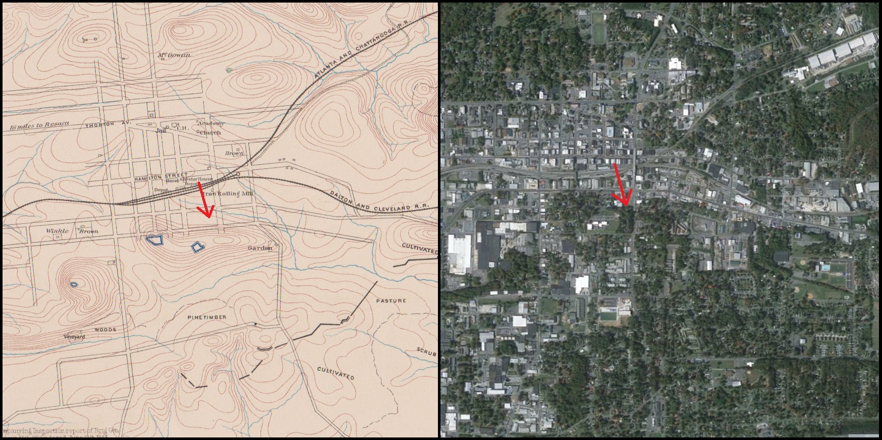
I’ve attached an image that compares an 1865 map of Dalton to a present day satellite image:
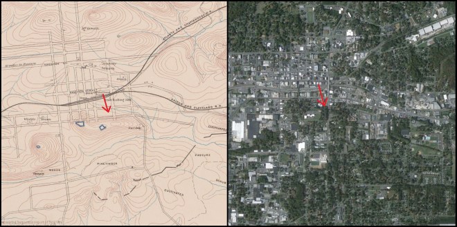
The red arrows not only point in the direction your viewer was looking, but also roughly in the direction of a Confederate attack which took place on August 14th, 1864. The Second Battle of Dalton, as it is called, was one of the final battles in Sherman’s Atlanta campaign. Despite the Confederate desperate and repeated cavalry attacks on the Union fortifications to the east of town (visible as the blue boxes in the civil war map), the Union positions held; two weeks later Sherman’s troops marched into Atlanta.
Today there’s not much left of the Union fort, but its location can be seen in the upper right of your viewer’s image, where a red brick junior high school sits on the same hilltop site.
Another bit of history:
The stretch of tracks in the photo lay on the Atlanta to Chattanooga line that was the scene of the Great Locomotive Chase in 1862 when Union soldiers captured a passenger train and damaged telegraph wires, bridges and tracks as they travelled north towards the Union lines in Tennessee. They ran out of fuel and didn’t make it to Chattanooga.
About a half-dozen readers correctly guessed 222 N Hamilton, but the following reader breaks the tie because he has entered the most contests without yet winning:
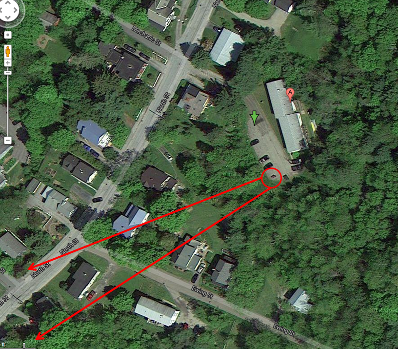
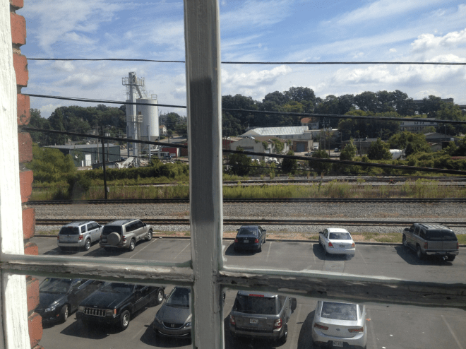
Wow. This might be my finest moment in Contest history. Well, luckiest anyway. I got this window on my first random, semi-blind stab, despite the fact that I’ve never even been within 500 miles of the locale. First the license plates. The orange blob in the middle, plus the alphanumeric sequence, plus the fact that they are rear only plates put me in Georgia. On a railroad track. With nothing else to go on. So I pulled up a railroad map. There are a lot of railroads going through a lot of small towns in Georgia. Because there seems to be several tracks here, I decided to start with places where two or more lines share the same right of way. So I started at the top of the map. Dalton, Georgia. BINGO! There was a big white hopper or silo, there was a parking lot right on the tracks, there was a white cement truck. First try. A semi-educated stab in the dark!
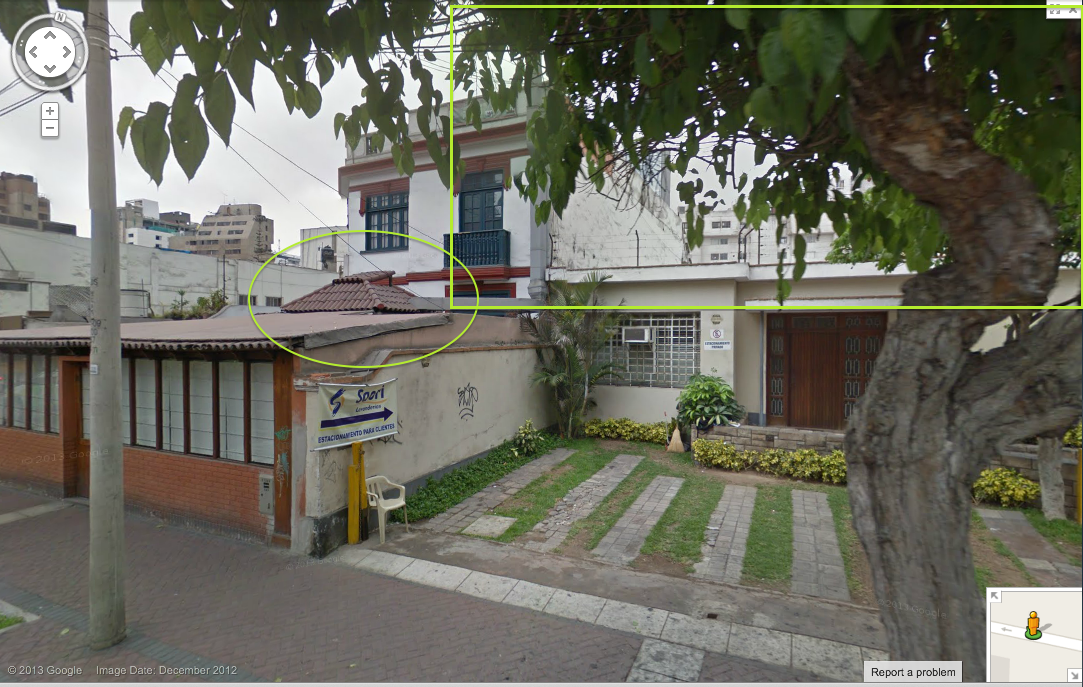
The StreetView of the town is very low quality. I can’t get a good image of the area to find a street number. I can’t even make out business names in the shots to help zero in, so I’ll go with StreetView’s best estimate of the address: 222 N. Hamilton St. Dalton, GA 30720. Second story rear window. I’ve made a picture to help:
Details from the photo submitter:
The address is 221 Depot Street, Dalton, GA. The GPS coordinates are 34.773016, -84.967386
222 N. Hamilton Street could also be considered accurate as it does identify the correct building but the wrong entrance. The window and entrance to access the window are on the rear of the building. The correct address for that rear entrance is Depot Street, but many people are unaware of the rear entrance or the name of the street. The front of the building is 222 N. Hamilton St.
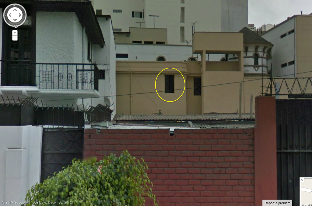
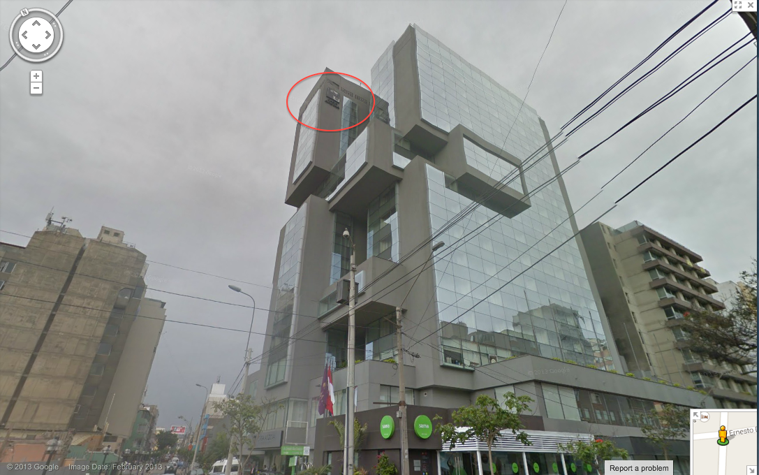
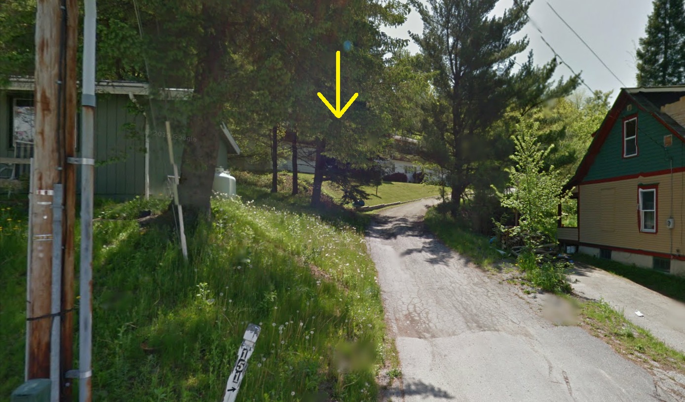
I am always amazed at how precise the winning entries are, so here is a shot of the window (circled in red) courtesy of Google Earth:
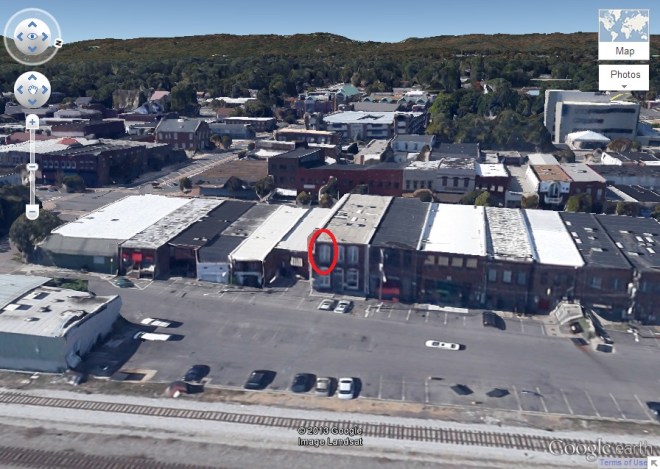
You can also see downtown Dalton and Rocky Face Ridge in the background. Thanks for using my photo!
(Archive)


