You have until noon on Tuesday to guess it. City and/or state first, then country. Please put the location in the subject heading, along with any description within the email. If no one guesses the exact location, proximity counts. Be sure to email entries to contest@andrewsullivan.com. Winner gets a free The View From Your Window book or two free gift subscriptions to the Dish. Have at it.
Category: Contest
The View From Your Window Contest: Winner #183
A reader writes:
First thought of Beijing, but then saw the palm trees. Mexico City and Santiago are both in the top 10 worst cities for smog and probably have palm trees, so I flipped a coin and Santiago it is.
Another:
I see cedars, what seems to be an Ottoman-era-inspired clock tower, and what appears to be Hebrew script (I’ve asked a Semitoliterate friend to check on that) on the blue building to the left. Maybe Haifa.
Another:
I initially wrote this week’s contest off as impossible, and maybe I should have stopped there. What convinced me to look was the Hebrew writing on the sign in the lower left, which narrows it down to … anywhere in the world with a significant Jewish population. But, the the mix of palm and pine trees is consistent with Jerusalem’s forested western edge, and the architecture isn’t too far off from some of the more modern neighborhoods. Plus, for some reason, this picture reminded me of the view overlooking the city from Yad Vashem.
Another:
This looks like Salalah, Dhofar Province, Oman during the Khareef (Indian Ocean Monsoon) season. Since many VFYW contest entries seem to be from hotel windows, I’m guessing from the Hamdan Plaza Hotel.
Another sounds the alarm:
Immaterial to my guess (Northern Coastal Spain?), someone needs to warn these people about what is clearly Godzilla emerging from the fog on the far right. Look out, folks!
Another gets the right city:
The Fairmont Hotel in San Jose, California? Sigh. I’m not even sure why I bother – I know someone is going to post the exact window and floor. But my husband said, “You might get on the list – send it in!” So here I go. Hats off to the person who wins by sending in the JFK-style diagrams of camera angles and such.
One such diagram:
Another reader:
This photo was taken from the Fairmont Hotel in San Jose, California. As for the room, that’s gonna be a bit of a guess. I’m thinking it’s somewehre on floors 10-15 and that it’s room position 23 or 28. I’ll guess it’s room 1428 (a suite, so maybe our submitter is living it up!).
Thanks for an easier one this week. I will admit I was slightly thrown off by what looked like Hebrew lettering on the blue building. Even when I figured out it was the San Jose Rep building, I was still adamant that it was Hebrew. Only when I looked on streetview did I see that it was the donors’ names in very tight lettering. Whoops!
The San Jose Rep sign really did this one in. I couldn’t read the word “rep” clearly, but knowing it said “San Jose”, my brain instantly recognized the fog and evergreens common in the valley. It just took a little searching to find that unique blue building and voila!
Another:
Thank you for throwing amateurs like me a bone here, with the words “San Jose Rep” appearing in the bottom left. It’s a repertory theater in San Jose, and the clock tower in the foreground is on the Paseo de San Antonio pedestrian walkway. The picture is taken from the Fairmont hotel facing South 1st street, I’ll say on the 14th floor.
Another:
As for the exact room number, I’ll never know how people come up with that, unless they stayed there themselves. I’ll guess it was taken somewhere around the ninth or tenth floor. Let’s say Room 924. The winner will no doubt have the exact room number and be able to tell you who stayed there on October 12, 2011, because it was them. Or somehow they have access to the floor plans and window views of each and every room in the place and have matched it with this picture. Kudos to them.
Thanks for this little contest, which takes me far afield most Saturdays.
Another:
You’re looking toward my house! The shot is taken from the downtown Fairmont Hotel, from an easterly window (I don’t know what floor – maybe 15 – leave that to the winner) above South 1st Street, looking SE over Paseo San Antonio. Below the fog and on the left some of San Jose State University campus is visible. And further beyond and center, me at South 16th – since 2000 when my partner convinced me to escape the fog of San Francisco and settle in the sunnier suburbs.
Another:
The Fairmont has 20 floors, so I’m guessing the 18th because the wall to the right keeps going up, so it’s not the top floor. Now it’s random guess time, so I say room 1824.
So very close. The winner this week:
After some tough contests lately, including my Stockholm window pic last week (which I didn’t expect to be so difficult), this was an easy one. San Jose is recognizable, if nondescript, even without seeing the San Jose Rep sign in the window pic. For a high floor shot with the clocktower and the San Jose Rep in the picture, it must be the Fairmont San Jose, 170 S. Market Street, San Jose, CA USA. This is confirmed by window shots on TripAdvisor and Yelp:
But what exact room? Last week, your reigning champ came so close, guessing room 507 rather than 509, though from the exterior shots one wouldn’t guess there are five floors. The only way I imagine his making that guess is that someone on TripAdvisor said there was a good view from room 507.
I will guess room 1827, because someone reviewing the hotel on TripAdvisor stayed in that room.
From the submitter:
Well, I’m terrible at the competition, so I thought I’d try the other side. This picture is taken just now from room 1827 of the Fairmont Hotel in San Jose,CA. I tried to angle it to miss anything obvious, and the fog helps a lot.
One other reader guessed room 1827, but he is a first-time contestant, while the winner has participated in seven contests.
(Archive)
The View From Your Window Contest
You have until noon on Tuesday to guess it. City and/or state first, then country. Please put the location in the subject heading, along with any description within the email. If no one guesses the exact location, proximity counts. Be sure to email entries to contest@andrewsullivan.com. Winner gets a free The View From Your Window book or two free gift subscriptions to the Dish. Have at it.
The View From Your Window Contest: Winner #182
Not a lot of entries for this week’s difficult view. One reader:
Not much to go on except rooftop architecture and the river. Based on my limited knowledge of both, I guess Riga, Latvia.
Another:
Halifax, Novia Scotia – unmistakeable. Unless I’m mistaken.
Another is more confident:
That clearly looks like Glasgow. After last week’s contest highlighted the tiebreaker rules, I’m going to accrue an unbeatable number of previous guesses in the event I do actually try and wind up tied!
Another is super confident:
Any graduate of the University of Wisconsin in Madison will recognize this view of the campus, with the yellow Stock Pavilion on the right, Liz Waters Hall in the upper distance and Lake Mendota on the left. The iconic peninsular Picnic Point juts out into the lake from the left. Harder to pinpoint the window from which the shot was taken, but probably somewhere in Van Hise Hall, the tallest building on campus.
Another:
I like to guess at images that look like somewhere I’ve been, rather than using all the technology other readers do. So, it looks like Tarrytown to me, with the Hudson River in the background.
A few others also guessed upstate New York. Or further north:
My wild guess is Quebec City, somewhere north of downtown and close to the river. That could be the Manoir Ste-Genevieve in the far distance, just to the left of the yellow house, and the peninsula could be Sinte-Petronille.
One reader had a lot of ideas:
The architecture reminds me of Germany, but the buildings are too new and the density is too low for Germany. The landscape seems Laurentian Forest, with a glacial lake or inlet, so maybe upstate New York, Quebec, New England, or upper US Midwest? Alaska or British Columbia? The buildings in the background could be timeshares – a resort town?
Another settles on the correct side of the Atlantic:
I have no wherewithal to defend this, but Amiens, France is my hunch. Spent a few similarly grey days there almost eight years ago while “studying” abroad.
Another:
This one seems pretty likely to be in northern Europe somewhere, but it seems a little too plain for Germany, so I thought it might be in the eastern side. Started looking at Prague, another place I’ve always wanted to visit, and it is so charming I never got around to looking at anywhere else. You can even street view in the zoo there! And the public art is amazing.
Another heads in the right direction:
The architecture screams Germany – particularly the yellow building with the gabled roof. Looks like northern Germany, Schleswig-Holstein, which isn’t particularly hilly except around the Holsteinische Schweiz, which also has lakes. Without knowing the exact location, it could easily be Kiel. Butcould also be Ratzeburg, Flensburg, any number of places. I’ll go for Plön.
Another gets much closer:
This has to be Oslo. It’s an image full of Nordic gloom, but also prosperous bourgeois architecture and a dramatic fjord. Not sure of the neighborhood, but my guess would be Nordstram, just to the east of the center of the city.
Another gets a similar hunch:
Just feels like southern Norway on a fjord. Colors of buildings and roofs are similar to those seen in the area. No pictures pop up in a quick search – so I’ll just lay my marker on Oslofjord, and let the pros dig deeper.
Enter the pro:
This week’s view comes from Lidingo Island on the outskirts of Stockholm, Sweden. The picture was taken from the fifth floor of the Scandic Foresta Hotel, possibly room 507, and looks north by northwest along a heading of 342.68 degrees:
It was room 509, not 507 – you’re really slipping, Doug. Meanwhile, only one other reader guessed even the correct country. The entirety of her entry:
Stockholm – Sweden – Europe
Close enough for a win this week. From the submitter:
Great to see my window photo used in the contest for the second time – the first was Contest #5, of the midnight sun over Tromso, Norway. Also exciting to see two of my windows from one trip; later in the day I took the photo, I flew to Beijing, where I took the photo you used from the Summer Palace.
As I wrote when I sent this week’s photo, it’s from room 509 at the Scandic Hotel Foresta, on the island of Lidingö in the Stockholm suburbs. From the Street View that contestants surely will find, the building appears to have only four stories. This is because the hotel is a sprawl up the hill from the historic castle-like Villa Foresta. The modern wings have made this a conference hotel. I was there to speak at a transgender health conference. So, if instead of a room number you get a circled window, I believe it is the top floor window visible in the Street View. The Foresta sign is quite visible as one crosses the bridge to Lidingö, and the hotel borders the well-known sculpture garden and museum of Carl Milles – the Millesgården, so this should be a more recognizable view than last week.
By the way, the Foresta had perhaps its most famous guests when the Beatles stayed there at the height of Beatlemania in 1964:
(Archive)
The View From Your Window Contest
You have until noon on Tuesday to guess it. City and/or state first, then country. Please put the location in the subject heading, along with any description within the email. If no one guesses the exact location, proximity counts. Be sure to email entries to contest@andrewsullivan.com. Winner gets a free The View From Your Window book or two free gift subscriptions to the Dish. Have at it.
The View From Your Window Contest: Winner #181
A reader writes:
My first thought was the Caribbean, so I searched for soil types, mountain profiles, street signs, checking who drives on right/left. My first choice was Cuba, and the mountains were similar, but not quite the right profile from the Vinales valley. I checked other red soil countries around the Caribbean, near mountains, tiny bit of Mexico, Guatemala, Honduras, right-hand-drive Caribbean islands. No joy. Dominican Republic is a possibility, but again, not the right config of mountains. Not even the little blue sign at the far right was a help. Africa? Seems too lush. Indonesia? Not lush enough. So I finally went back to my original guess: Vinales, Cuba.
Another:
I can’t spare the time this weekend to give this contest its due, but the view reminds me of certain coffee-growing locales, so I’ll take a wild swing and say this is in Haiti. I’m probably wrong. It’s probably Sumatra or something.
Another:
Now that’s a challenging VFYW! I’ll be gobsmacked if anyone nails the precise location. Aside from it being tropical, I haven’t much else to guide me, so given it’s prominence in the news lately, I’ll go with somewhere in the Philippines, someplace that was spared the recent wrath of a typhoon.
Another:
This reminds me of the view from the outskirts of La Paz. I found myself there in November 2009, while going to see Cholita wrestling. The evening culminated in me getting knocked out of my chair when one of the lucha libre fighters threw another into the crowd. Photographic evidence attached:
Another:
I think this is in Darjeeling, India. I’ve never been there, but at first glance, the pic reminded me of India. My mom, who is Indian, is always telling me about hill stations, so I googled a few. Am I close?
Not very. Another gets on the right continent:
Definitely Africa. Looks very much like an area of northeast Tanzania I visited a number of years ago called the Usambara Mountains. So I’d guess it’s somewhere in the main city of that area, Lushoto.
Another:
This looks like a scene from Mbarara, Uganda. I could be wrong, but I’m in Mbarara now and it looks like the view from my window!
Another:
Baffling.
I believe that the mountain in the right background is Table Mountain which overlooks Cape Town, South Africa. This photo is obviously at elevation, but I can’t put together the distance and population on Google Earth. At first, I thought it was north of Cape Town, but I’m now convinced it is actually southeast. My best guess is in the foothills above Somerset West.
Another:
Can’t be South Africa, because it was South Africa last week. Nevertheless, I see a Toyota Yaris, which is common in South Africa. The Yaris appears (hard to say) like it may be right-hand drive, as I can’t make out a steering wheel on the left side. South Africa maybe. The multi-colored paving slabs in the parking lot below us are also typical of South Africa. I even found a company that makes them in Cape Town. The chairs too! They appear to be of a kind made by ISA Group in South Africa – from their web site, I’d say these chairs are “The Snapper” model. Regardless of last week, I’ve got to go with South Africa again. But where in South Africa?
Well, then you’ve got the two dirtbags, er, I mean, backpackers outside the cafe below, the one with the chairs. These two have a decidedly “Motorcycle Diaries” look about them. And if I know my comrades, they would desperately love to see Kruger National Park, but wouldn’t be caught dead in the company of fellow tourists (travelers, I mean, these guys are clearly travelers). So my guess is that the travelers are NEAR South Africa’s prime tourist target – Kruger – but spending as much time as possible in a shanty town so as to maintain their cred. Which leads me to: Kanyamazane, a township near Nelspruit. Can’t find any landmarks to confirm, but it’s a plausible theory. Final answer.
Another:
I can’t tell you the exact place, but this feels very much like some of the places I have seen up along the lower boundaries of the Aberdares range or Mount Kenya, although really it could be anywhere in tropical African highlands. I will take a guess and say it’s Chuka on the eastern side of Mount Kenya.
Another:
I saw this photo and it brought me back to the three years I spent living in Guinea in West Africa. But after looking at the photo a little longer, I don’t think it is Guinea. It’s too small to be a capital city, so must be some upcountry town, but there’s a lake in the distance and possibly a volcano – not things Guinea has. So I’m thinking it might be looking at the lakes in central Africa. I’m going with Bunia, DRC, which seems to be just far enough way from a lake and the mountains on its shore. It looks like it’s taken from a small guesthouse. You can tell by the clean courtyard and the well cared for bushes. But I don’t know which one.
Another:
I give up. There’s pretty much nothing I can identify to indicate a precise city. I’m resigned to this week’s prize going to a flagstone-colourist or garden furniture distributor, or someone doing a doctorate in global windshield sticker formations. My first instinctive thought was Caracas, but the single-story shanty towns aren’t built up enough for the Latin American conurbations. Looks from the fencing like it could be East Africa, but given Uganda, Kenya and Tanzania all drive on the left, I’m inclined to say Rwanda, “the land of 1000 hills”. Given that the hills are all I have to go on, and I can’t see the shape for the clouds, I’m going to punt at Kigali, but am resigned to knowing I can’t find the actual window this week.
Another gets the right country:
This has got to be Addis Ababa, Ethiopia. Eucalyptus trees, tin-roofed huts, the standard school structure on the hill to the left. The thing that gives me some pause are the motorcycles in the parking lot; there just aren’t as many scooters or cycles as I’ve seen in other developing countries, but there are some. As for specific location, I’ll go with Mount Entoto, looking south. I submitted a VFYW photo from Addis a few months ago, but I’ve since left, so this brought back some fond memories.
Another:
It looks like Addis to me; I was there for a week three years ago when we were adopting two children. Of course, that’s the only African city I’ve ever been to, and since this looks like Africa, I’m shooting in a dark a bit.
Another:
Looks like Addis Ababa to me, more specifically a view from somewhere north of the city, Entoto or Gulele.
Another:
Addis? I’m always way wrong.
No one got the right city in Ethiopia. Details from the submitter:
Lemma Hotel, Room 301, Hossanna, Ethiopia, taken 11/15/13
Of the four readers who guessed Addis Ababa, none of them are correct guessers of previous contests. The first two Addis entries posted above are from first-time guessers, while the second two are both from second-time guessers, making a tie-breaker very difficult. But since the second-to-last entry guessed “somewhere north of the city, Entoto or Gulele”, and Hossanna is actually south of Addis, the winner this week goes to the last entry, from the reader who is no longer “always way wrong.”
Update: A last-minute entry from our grand champion, prior to the deadline:
A few months ago a Dish reader mocked your choice of Addis Ababa for VFYW #161 because they thought it was too hard. I can only imagine how they’re gonna feel about this week’s location. One thing’s for sure though; views are much harder to find when the satellite imagery shows an empty lot instead of the hotel the picture was taken from.
This week’s view comes from Hosaeana, Ethiopia, a small city located approximately 120 miles from Addis Ababa. The view looks south by southwest from the Lemma International Hotel along a heading of 208.42 degrees towards the hills just above Jajura. The exact coordinates are 7°32’40.76″N 37°51’3.00″E, and the picture was likely snapped on the fourth story (third numbered floor) of the hotel:
Incredible.
(Archive)
The View From Your Window Contest
You have until noon on Tuesday to guess it. City and/or state first, then country. Please put the location in the subject heading, along with any description within the email. If no one guesses the exact location, proximity counts. Be sure to email entries to contest@andrewsullivan.com. Winner gets a free The View From Your Window book or two free gift subscriptions to the Dish. Have at it.
The View From Your Window Contest: Winner #180
A reader writes:
You’re killing me … lots of clues, but I’m still clueless. Left-hand driving, which is mostly in tropical countries, except for UK and Japan, and this doesn’t look like either to me. I can’t read the signs, but they seem to be in a different script. Maybe Thai, but vegetation doesn’t look Thai. I thought about New Zealand, but the train in the background doesn’t look like any of the images I found for “New Zealand Trains.” There’s a KFC, but where isn’t there a KFC? I tried to figure out who made the air conditioners on the roof. Looked like an “O” logo. There is a company called O General that sells AC units in India, but couldn’t find any units that looked like those. White is the most popular car color worldwide, so that’s no help. But cars look relatively new, which says prosperous country.
I’m going with Japan. Let’s say Matsumoto, because I like the way it sounds.
Another:
Charleston, West Virginia? I don’t even know why I’m bothering. It just looks like Charleston, but I have no idea what building the picture was taken from. But, then again, those look not unlike windmills on the mountain. Massachusetts, maybe? No, that’s definitely Charleston. The building in the foreground looks like the kind of federal office building that Robert C. Byrd so fought for.
Another:
I think it’s somewhere in Tasmania. The cars drive on the left, so it’s a former British place, and it looks like it’s just rained in an otherwise dryish region, and the light looks like it’s in the Southern Hemisphere.
Another:
Ok, the photo indicates that this was taken 2013-11-04 at 10-13-38 PM. I would think that only the Northern European countries are in play – Sweden, Finland, Norway as they would have sunlight at 10pm at night in November or so I think. I also think the tip off is the fir trees. I searched Google images for bridges in all three and the closest I came was the Vousaari Bridge in Vousaari, a suburb of Helsinki. So I searched, and boy does Helsinki have a lot of bridges and waterways, but I can’t locate the spot of the photo. I’m just fishing for closeness points.
I’m also think that this could be Canada as well. There’s an American style pickup in traffic heading towards the water, but given a lapse in any other clues, I’m sticking with Helsinki.
Actually, “2013-11-04 at 10-13-38 PM” is just the timestamp of the screenshot of the original image, something we do to bypass the meta data that would reveal the exact geographical coordinates. Another reader:
You people are ruining my weekends.
I get a few right and think, OK, I’ve got this figured out now. Last week’s was bad enough, but this week is awful. There are so many clues I thought I would find it in five minutes flat. Instead we can’t even agree on what country it’s in and I am probably off by several thousand miles again.
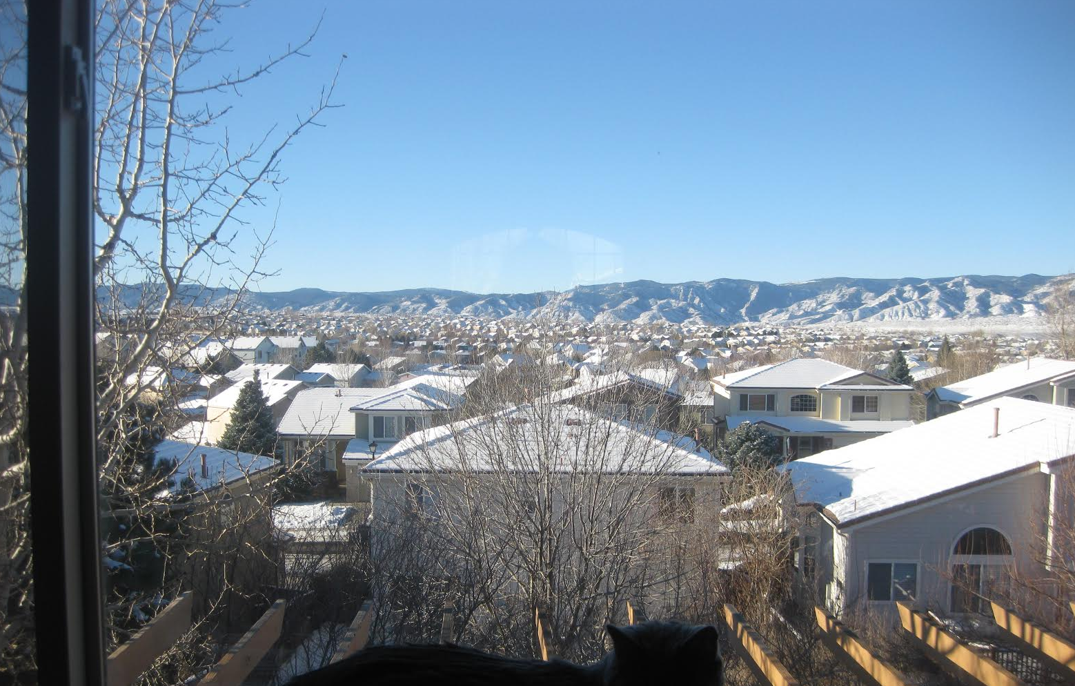
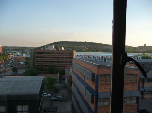
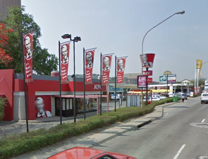
We argued over hemisphere. I say the tree in the middle is starting to bloom and the white car in the alley in the foreground is parked on the left, so it must be the Southern Hemisphere – Australia or South Africa. The housemate says no; it’s a tree starting to shed its leaves and the two people you can see are fairly well bundled up, so it’s fall somewhere in the northern half of the world. The visible cars are sold pretty much everywhere in the developed countries. I said, well, there’s a KFC and an elevated railway, so how hard can it be? I booted up Google Earth – if you go into the “more” section on the menu and click Transportation, you see a zillion highway numbers and bus stops, but railroads are nice black lines. That’s a big help when there is a railroad track or three visible. I found if you do a search for “KFC near [name of any city, country], Google Earth will put pink dots on the map of the entire world, each of which
represents a KFC store. For the city you name, it gives you selections A-J on a page, with as many pages as necessary to name them all.
Unfortunately, Wikipedia says that “As of 2012, there were over 18,000 KFC outlets in 120 countries and territories around the world. There are 4,600 outlets in the United States, 4,400 in China, and 9,000 across the rest of the world.” That is a lot of pink dots to check. It turns out that lots and lots of them are near railways and hills. It’s an older sign they don’t use any more in the US and some countries, and you use four-year-old photos, so the store may have closed.
We looked for other clues – that weird white scalloped wall, the hills, possibly wind farm on top of one hill, the tower you can see past the top of another, elevated railways, weird traffic signals. We tried to figure out what those installations wall of the brick building in front are – they look like pipes for some kind of heating system? I have decided there is not nearly enough information on the web about rooftop air conditioners; I think those are made by LG, but they sell them all over the place. There are no satellite dishes visible, so I looked for places they might be banned. Nothing paid off.
I thought it was Australia, because they seem to use the bucket on a short pole the most, and those strange short traffic signals show up in a few towns. So my guess is Brisbane, because I fell in love with it looking at photos of the bays and beaches and rivers and birds.
My first job was at KFC in 1972 – I negotiated a salary of $1.60 an hour, way more than the other fast food place in town, Jack in the Box, would give me (only $1.35). We spent a lot of time seeing how far we could slide on the greased kitchen floor after closing, and I sliced off the end of my finger cleaning a machine. Good times. I wouldn’t eat chicken for several years after that, and now I hate them again. Your fault.
Another gets the right country:
While I can’t identify the exact location in the city, I’m sure it’s South Africa and have a pretty good idea it’s in Pietermaritzburg or somewhere else in KwaZulu-Natal. Firstly, the diagonal lines at the intersection on the left side of the picture and the left-hand drive on the car on the street in the bottom middle. Also, the deciduous trees on the hill mean it has to be somewhere that gets cold enough for them to lose their leaves. But you also see air conditioner condensers, therefore it’s a place that gets cold in the winter and warm in the summer. It’s also somewhere where you have security concerns (note the walls and gates on the edges of all the buildings. Based on the terrain I’m going to guess Pietermaritzburg.
Another gets the right city:
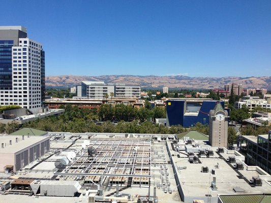
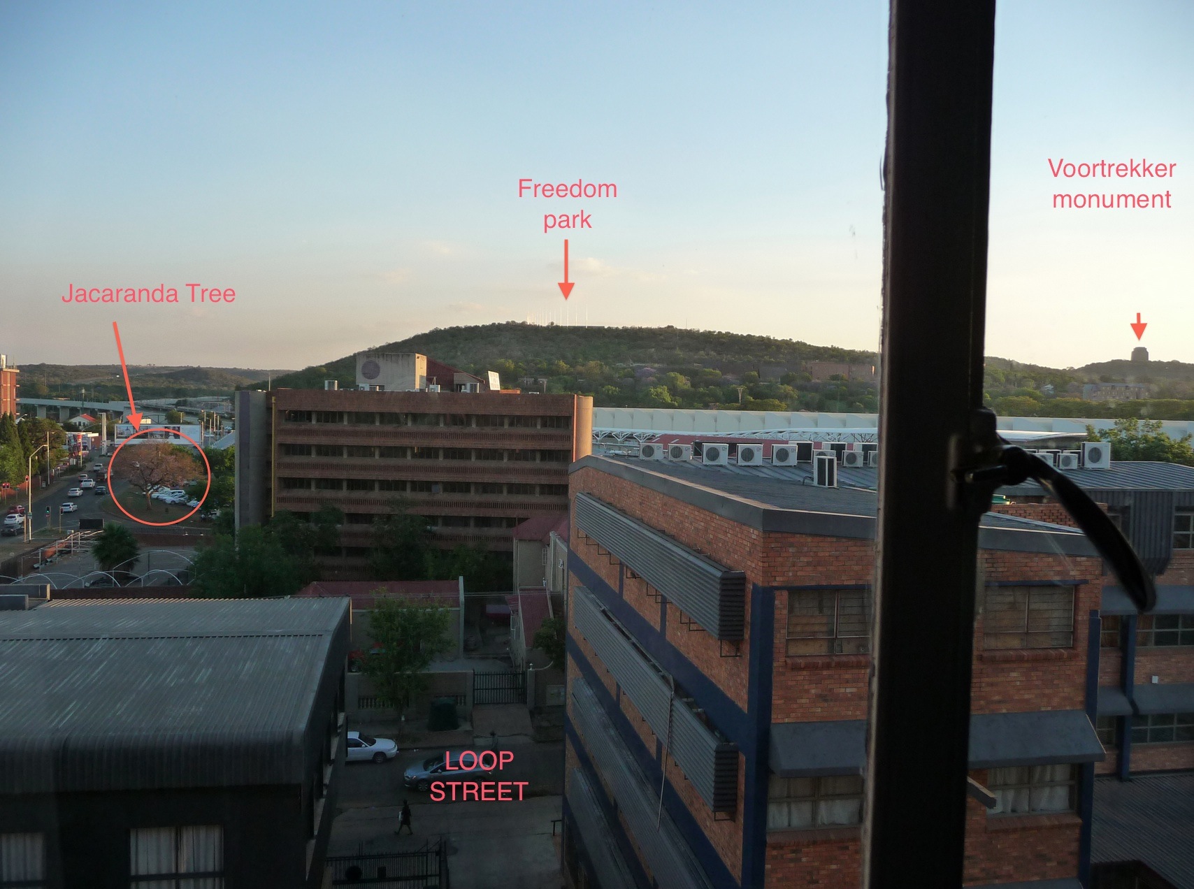
Boy, these things are hard. It looked a lot like the highveld on a winter afternoon, and then I spotted the Voortrekker Monument in the distance, making it Pretoria, South Africa or its surrounds. I think, based on the relative location of the sun, this must be near Unisa, close to an on-ramp to the highway, but my Google Street View skills aren’t hot enough to pinpoint it exactly.
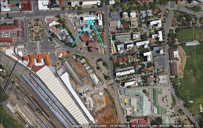
Pretoria it is. An aerial view:
Another gets the right building:
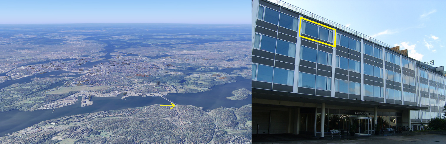
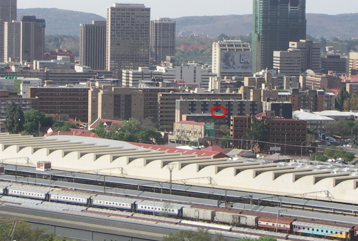
Having lived in South Africa, I immediately recognized the purple jacaranda tree in the background, which Johannesburg and Pretoria are famous for. The “robots” (traffic signals) also had a distinct South African appearance. When I zoomed in, I also saw the modern-looking passenger train in the background – which I assumed must be the Gautrain. These clues made zeroing in on the location fairly easy. The picture was taken from the Manhattan Hotel in Pretoria, South Africa (or Tshwane, the official name for the municipality). The hotel is located at the corner of Scheiding Street and Thabo Sehume Streets in the Pretoria CBD. The picture was taken from a window on the backside (southside) of the hotel. I would guess it was from the 5th floor (6th floor in US numbering).
Another visual entry:
Another reader:
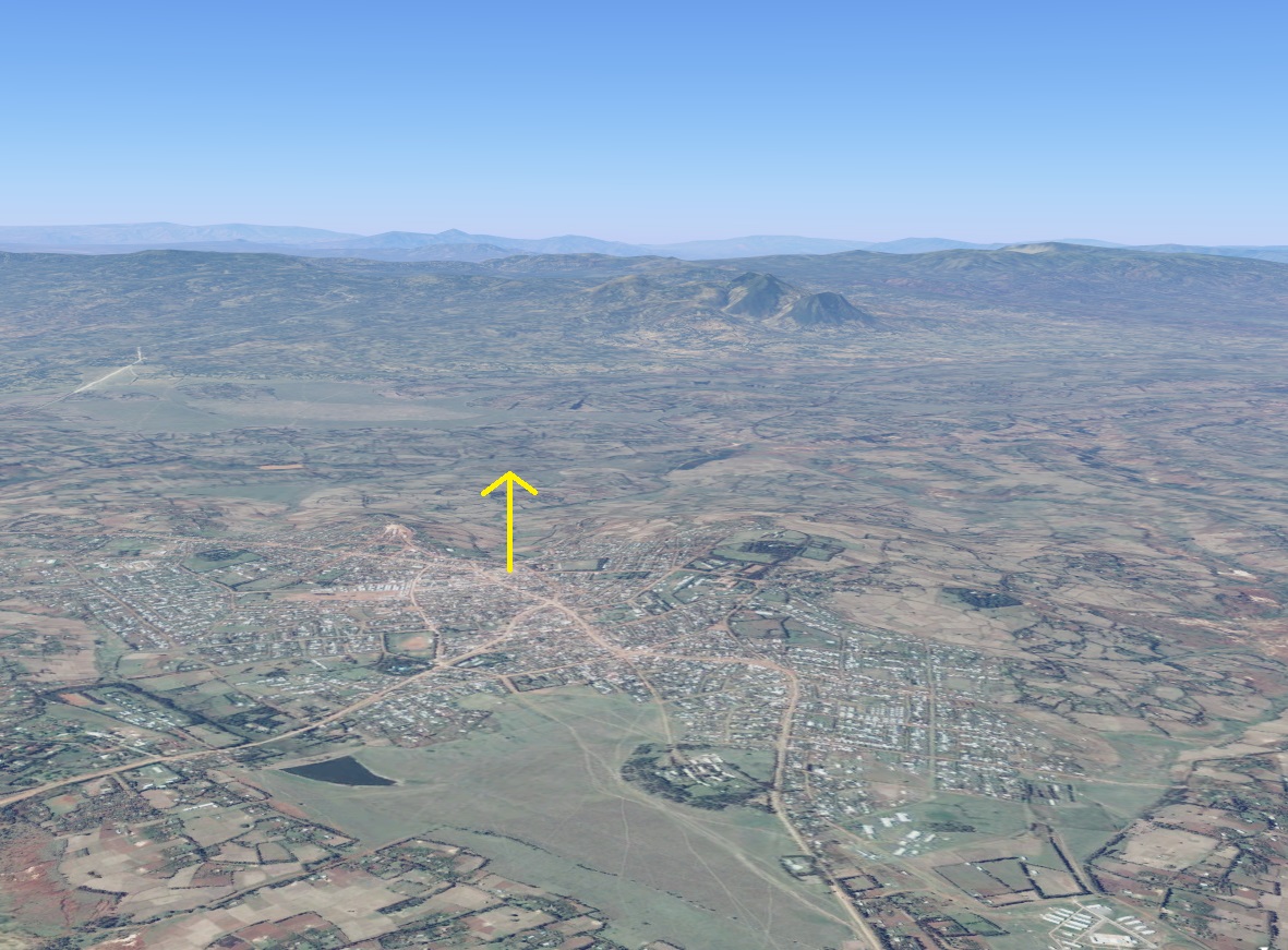
The poles (or “reeds”) of Freedom Park helped orient me. Freedom Park, by the way, honors people who died during South African various conflicts, going back centuries, including people who died in the struggle against apartheid. It’s the Rainbow Nation’s answer to the nearby apartheid-era Voortrekker Monument, which used to monopolize the view (and still kind of does).
Another adds, “I’m a historian, and I found a crazy archive of sorts in the Voortrekker museum’s vaults.” Another looks to the nearby rail station:
The elevated platform on the left side of the photo, which appears too slim to be a highway, immediately indicated to me that this is a view of the Gautrain track (a mass rapid transit system that was completed in 2012 and connects Jo’burg and Pretoria). I searched Gautrain stations on Google, and the one in Pretoria, with that unique wave-style roof, immediately stood out and told me that I was on the right path. A little playing around on Google Earth helped me to find the specific building, which is the Manhattan Hotel located on Scheiding Street.
Another zooms in on the hotel:
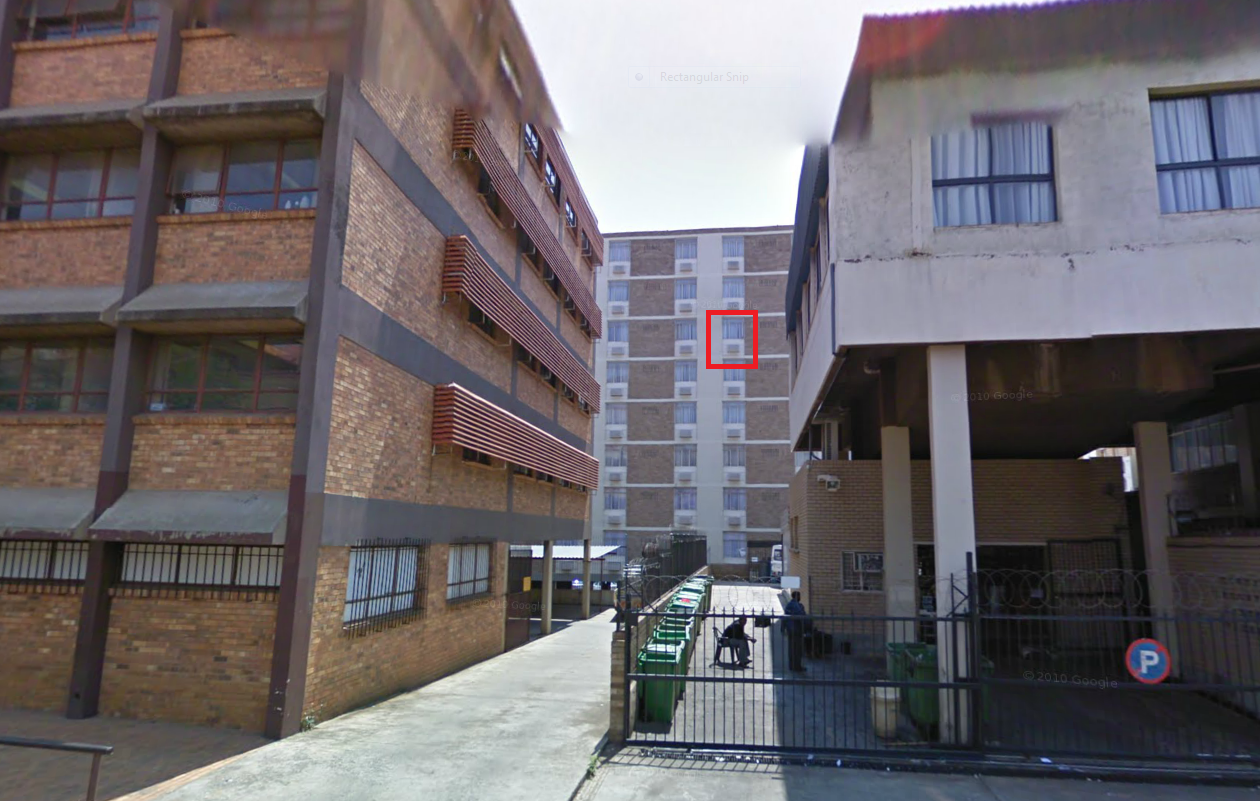
I have a suspicion that the scalloped roof of the railway station will be immediately recognizable to residents and visitors of the city, but I did do this the old-fashioned way and hopefully that will count for something! I started out noticing the left-hand traffic, limiting this to a few likely candidate countries. Too spread out to be the UK, and the brick made it seem unlikely to be India. Australia? South Africa? Japan? Realizing the two people walking at the bottom of the picture were black, my attention immediately turned to South Africa. Googling “South Africa traffic lights” revealed the same shape seen on the road on the left as confirmation. The rail station with its unique-looking roof seemed to be the best clue, so looking up images of different rail stations in South Africa led to a perfect match with Pretoria. A bit of orienting from there and we have the Karos Manhattan Hotel, 247 Scheiding Street, Pretoria, South Africa. I would guess the 6th floor, from the window highlighted in the attached picture:
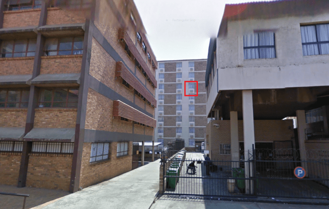
The correct floor is actually the 7th, which about a half-dozen readers guessed. Of them, two readers have previously gotten a difficult window view (“difficult” defined by having 10 or less correct guesses) without yet winning. To break that razor-thin tie, we counted the total contests each of the two readers have participated in. The following reader has 8 contests under his belt. Money quote from his highly-detailed entry this week:
I should note that I have tried, hard, in MANY of these contests. I occasionally get the right country and I once got the right city (mostly by luck). But this time I KNEW I was close, really close. At this point, I literally heard angelic music and noticed a bright glow in my bedroom. I found this distracting, so I turned down the volume and brightness on my laptop and carried on.
But the following reader ekes out a win this week with a total of 10 contests. Money quote from his extensive entry:
Worthy of note is the presence of 40 to 70 thousand jacaranda trees, which had led me to consider the southern hemisphere for my search. Pretoria in South Africa is popularly known as The Jacaranda City due to the thousands of jacaranda trees. Interestingly, the jacaranda are considered an invasive species, as they were imported from South America, and are no longer allowed to be planted.
I have previous correct submissions of Depoe Bay, Waterton, Sierra Vista, Finca Magdalena, Hiangyin, North Ballachulish, Fayetteville, and Lima, Peru.
And now Pretoria. For the record, here are the exact details from the photo’s submitter:
Monday, 4 Nov, 2013, at 6 p.m. Room 707 (facing south), Manhattan Hotel, 247 Scheiding St., Pretoria, South Africa. The jacaranda trees are blooming in town, but I don’t think you can see any in this pic. The global “access programs” groups of the Clinton Health Access Initiative are here for an annualish meeting. An inspiring bunch of people, and generally a lot of fun. We’ve been to Jo’burg and Dar es Salaam before (as well as Goa, India and stateside in Boston, NYC, Chicago).
I know Andrew doesn’t have much love for the Clintons, but I hope he realizes what a huge impact the Clinton Health Access Initiative has had on getting anti-retrovirals to the people of Africa and SE Asia. As we move on from ARVs, we discussed some exciting new initiatives in our meetings in Pretoria.
(Archive)
The View From Your Window Contest
You have until noon on Tuesday to guess it. City and/or state first, then country. Please put the location in the subject heading, along with any description within the email. If no one guesses the exact location, proximity counts. Be sure to email entries to contest@andrewsullivan.com. Winner gets a free The View From Your Window book or two free gift subscriptions to the Dish. Have at it.
The View From Your Window Contest: Winner #179
A particularly tough one this week. A reader writes:
Salt cedars. Not a Turkish style of minaret, but not bulb type either. Cliffs, particularly the one off to the right in the distance. Satellite dishes looking SW or WSW, so mountains to the west and north. Looks like water in the distance – river valley? Probably late afternoon with the haze/pollution. After looking at, literally, thousands of minaret images, systematically googling mosques, and looking at different cities with proper orientation, for different countries where salt cedar grow, I give up. Iran? Sigh. But fun anyway.
Another:
The double minarets stood out at once. The landscape also made me think of Turkey. Turning to Google maps to look for Turkish towns on plains but near rocky outcroppings, the town of Batman in South Eastern Turkey caught my eye. That is just too cool a name not to be my guess – Batman!
Another:
The mosques, palatial architecture, and rocky cliffs scream the Gulf … and then the lush greenery throws me for a loop. I’m going to guess Salalah, the greenest town in Oman, just because Oman is my favorite off-the-beaten-path travel destination and I’ve always wanted to go to Salalah. For the fun of specificity, I’ll go for a total guess and say the Frankincense Land Museum on Sultan Qaboos Street.
Another:
I have spent more time trying to find this one window than all the other contests I have entered. I have looked at Google, Flickr, blogs, Wikipedia until my eyes are half-blind. My instinct says Iraq but I can’t find a city there that matches, so I am going with the only thing I found which was the green and white striped curbs, which they have in Pondicherry, India. Might as well be off by a continent or two!
Another:
Blergh!
I give up. I didn’t think this one would stump me so much. I am going to guess Suez, Egypt. I’m anxious to see the answer so I can look at a map and see where I was getting thrown off the scent.
Another:
One drunken night, upon hearing of my love of deserts, a friend told me of his time in the Atlas Mountains of Morocco. I remember nothing of the description, only the image it seared in my mind. This approximates it – an arid land, punctuated by the lush of green where water springs: all overseen by an ancient and majestic range rising toward the sky. I will travel there someday. And I will find that the reality transcends and surpasses the weathered image. And I will hunt down the building from which this photo was snapped.
Another:
My guess is Ras Al Khaimah in the United Arab Emirates. It is almost certainly a view from RAK looking toward the border with Oman.
Right country. Another gets the right city:
Probably a biased guess (since I live in the country), but it looks like that may be Jebel Hafeet mountain in the background. Which would mean that you are in Al Ain, Abu Dhabi, UAE. Which would be a weird place for you to be, but that’s neither here nor there.
Another gets the right building:
Irrigated gardens around aging villas, palm groves, beige minarets and what looks like a hazy Jebel Hafeet in the distance. This sure looks like Al Ain, the “Garden City” of the UAE. Since the picture is up fairly high, I’ll wildly guess that it’s taken from a guest room at the Al Ain Rotana.
Al Ain Rotana it is, and the only reader to guess it. From the submitter:
The contest photo was taken from Room 409 at the Al Ain Rotana Hotel, Al Ain, United Arab Emirates. The photo looks south. The core of the city is out of the image to the left.
Al Ain is an ancient crossroads and oasis about 80 miles inland from Dubai, on the border with Oman. If Dubai is a performance on the world stage, Al Ain is the opposite: a comfortable town for the Emiratis. I was struck by the investment lavished on parks, boulevards, public squares, and a range of architecture, all under a five-story height limit defined by the main mosque. (Mobile phone towers, oddly, get a pass.)
Al Ain is famous for its many oases, which account for much of the lushness in the photo. They are managed as small allotments for date-palm farmers, but are also laced with public paths where the city’s noise vanishes under the endless trickle of falaj irrigation channels.
The high mountain barely visible in the distance is Jebel Hafeet, whose summit can be reached by a steep hairpin road that tempts every Ferrari. The ridges in the near right are part of a whole chain of ridges that lace the city, mostly spreading from Jebel Hafeet like cracks in a window.
The taxi driver who delivered me there at 150 kph said that his brother is missing in Syria but that his mother in Damascus still sees him alive in her dreams. There seemed no appropriate moment to say that a mere 120 kph would be fine with me, so I closed my eyes. Lush and serene Al Ain was the perfect place to open them.
(Archive)


