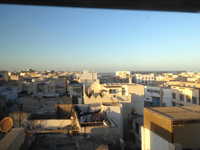
The View From Your Window Contest

vfyw

You have until noon on Tuesday to guess it. City and/or state first, then country. Please put the location in the subject heading, along with any description within the email. If no one guesses the exact location, proximity counts.  Be sure to email entries to contest@andrewsullivan.com. Winner gets a free The View From Your Window book or two free  gift subscriptions to the Dish. Have at it.

The View From Your Window Contest: Winner #188

vfyw_1-18

A reader writes:

Really?  I re-upped my subscription only to be mocked with this utterly ridiculous contest photo? It all looks vaguely Scandinavian, but that is not the point.  So all the stuff you write about on Sunday is obviously BS, since it is increasingly clear to me that you are beginning to taunt your readership.

I like that. I wish I had renewed for more that $25.00.

Another describes the scene:

Snow, low mountains, old industrial buildings in the foreground, turn of the 20th century-style housing in the background. This is a hardscrabble industrial town of the kind that you find throughout the northern reaches of Appalachia (just drive any part of I-81 for that experience). Pennsylvania alone has dozens of towns/cities that look like this, and I don’t have the patience to scour every single one on Google Earth. I’m going with my gut based on that mountain in the background: It reminds me of many a drive up to college past Binghamton, NY.

Another:

Early on in this contest I often spent an hour or more trying to determine the place. Then all the experts began their triangulation and GPS, etc. I could never keep up. I always try for the right continent and usually get that right. Starting this year, I thought I’d try for Hemisphere. That shouldn’t be too hard. This photo follows a pattern, hills in the background, a river, perhaps a lake, leafless trees and tin roofs. Another feature is the railroad track. A modern building – office-like looking. I was in Quebec last fall, so it’s as good a guess as any.

Right hemisphere. Another:

This looks like central Pennsylvania to me – but I don’t have Doug Chini‘s resolve, so I won’t be following every train track in the state looking for those bumpy roofs. Instead, I’ll just guess Wilkes-Barre, Pennsylvania – and I’ll look for my entry to appear well above the jump!

Another:

moca

Well, I thought this was going to be two easy ones in a row.  It looks like a glamorous new lobby has been added to an old New-Englandish warehouse. Some kind of art/cultural destination near a railroad. Dia Beacon? No. MassMOCA? The warehouse has the same kind of scalloped edge! Has to be! Only I can’t for the life of me find this view on the map.  But I’ll submit North Adams, Mass, in case the same warehouse builder had other business in the area.

Another:

My initial reaction was that with visible dirt on the ground and less-than-impressive mountains in the background, we are looking through a window somewhere near Borat’s native Kazakhstan. And with the dimness and angle of the sunlight, I think we are somewhere near 49.0278° N latitude (give or take). Looking at cities around this latitude, I have choices of Lviv, Ukraine or Erdenet, Mongolia (which no one in the US has ever heard of). I’ll choose Erdenet. If this is right, I’d love to hear why anybody would ever be in Erdenet, Mongolia …

Another lands on the right continent:

This week’s picture lends new meaning to the word “grim.” You have never before used a photograph that portrays cheerlessness to this extent. It looks like a place which the world has left behind. My mind took itself immediately to Russia and the old Soviet Union, with the birch tree and unique narrow-gauge railway tracks (which helped lead to Hitler’s defeat) supporting my mental travel. Those several church steeples could be atop sanctuaries of the Russian Orthodox faith. With a higher resolution screen, it might be possible to determine what the parabolic shape in the middle background of the picture represents. It may be part of a stadium. The abundance of green, non-deciduous trees and the profile of old, worn down mountains have helped me convince myself that this is in the southern part of the Caucusus. Traveling to this place, sitting with a cup of coffee, and watching the place come to life on a sunny day in May, is an intriguing notion.

Another:

Gothenburg, Sweden? Because of the swooping-sided stadium barely visible in the background. I think that’s Ullevi stadium, but I can’t figure out the perspective and can’t spend any more time on it. I’d guess the photo is taken looking S-SE toward Ullevi stadium from around the port somewhere. Or not.

Another gets the right country:

The middle-distance houses look very German, especially the ones with pointy roofs. A run-down look, so probably east Germany. The hills look something like the tail-end of the Harz, so I’d go for Thale.

Another:

This is a hard one. The birch tree in the front and some vaguely German-looking houses far in the back. Also, Germany is kind of keen on the solar power these days, so the solar batteries on the roof of a warehouse are consistent, and their angle fits the general latitude of northern Germany. Beyond that – no clue. So I am going on a limb here and guess Bremen.

Another nails the right city:

This week’s contest was done in a rush on Tuesday morning because I was out of town for the MLK holiday in a surprisingly cold Miami.  At first I was lost on this one, but the green roof, the hills in the distance, and the buildings made me think somewhere in Germany.  Then I noticed the stadium in the middle and started looking for stadiums in Germany with that profile.  Thanks to some Wikipedia and Google image searching, I settled on the Mercedes-Benz Arena in Stuttgart. From there it was about 20 mins of Google maps searching to find the right building, the BülowBogen Business Center located at Heilbronner Strasse 150. The picture was taken from an office on the back side of the building overlooking the train tracks.  Based on the height of the power lines for the train, it was probably taken from the sixth floor in the building’s southern half:

Stuttgart 2

A few other readers also correctly answered the BülowBogen building:

The electrified railway in the foreground looked like Germany to me, as did the yellow-brick stone buildings with (partially) skylighted roofs that look like the typical industrial architecture in so many railroad adjacent industrial areas from the late 19th / early 20th century. However, these indicators were only good for a first guess. What gave it away was the quite distinguishable top of a stadium in the medium background. That and the hills in the far background limited the choice of possible cities. The stadium in the medium background is Mercedes-Benz-Arena, home of German Bundesliga soccer club VfB Stuttgart. The BülowBogen Business Center is the only higher building in the vicinity of the point from where the photo could have been taken (3rd or 4th floor maybe). On Google maps’ satellite view, the black office building on the right is still under construction.

I wanted to attach a screenshot from Google Maps with arrows and circles and stuff as so many do at these contests, but the distance between point of photography and stadium was too big to be informative. Also FYI: I was given a one-year membership as a present last Christmas. Now, this is my first TVFYW contest I participate in. Good luck to you guys in your efforts!

Thank you! As far as the winner this week, the following reader guessed the closest floor of the BülowBogen building, has participated in the highest number of previous contests among this week’s finalists, and produced the most detailed entry:

stuttgart

The view is of Stuttgart, Germany. You can see the stadium vaguely in the background. It’s near the Mercedes-Benz factory (which the stadium is named after). I thought it was weird to see a professional sports stadium without any large buildings or skyscrapers around, and that was a tip that this isn’t a view of an American city. So what sort of small towns have professional sports stadiums? Numerous cities in Europe. The shed like structures are actually some sort of music venue and restaurant space called the Wagenhallen – photos of it here.

The picture itself was taken from the BulowBogen Business Center at 150 Heilbronner Strasse. I believe the room that the photo was taken from is on the fourth floor. I’ve attached a photo of the building with an arrow pointing to my best guess at the actual window your picture was taken from:

Actual window

From the submitter:

I’ve sent similar shots from my workplace before, but I particularly like this one, with the early-morning sky and the lighted interior of the nearby vocational school. Location: Stuttgart, Germany, taken from the second floor of the Bülowbogen office building at Heilbronner Strasse 150. Time: 8:45 am, Jan. 9, 2014. Description: Directly adjacent to the railroad tracks on the right is a recently built vocational school. To the left is a late-nineteenth century railroad car depot which is now being used for artist ateliers and various cultural events. In the far distance along the Neckar River (not visible) is the Mercedes-Benz Arena, where the local Bundesliga team plays. The area in the middle distance will be undergoing a radical transformation in the next several years because this belongs to the development site of Stuttgart 21, a controversial and very expensive project in which the current above-ground railway station will be transformed into an underground station, freeing up the immense area taken up now by tracks for new development close to the city center.

(Archive)

The View From Your Window Contest

vfyw_1-18

You have until noon on Tuesday to guess it. City and/or state first, then country. Please put the location in the subject heading, along with any description within the email. If no one guesses the exact location, proximity counts.  Be sure to email entries tocontest@andrewsullivan.com. Winner gets a free The View From Your Window book  or two free gift subscriptions to the Dish. Have at it.

The View From Your Window Contest: Winner #187

vfyw_1-11

A reader writes:

Okay, if that ain’t the angel Moroni on top of that spire in the distance, sitting on top of a structure looking very much like a Mormon temple, then I don’t know what that could possibly be.  The surrounding area looks a lot like San Jose, Costa Rica, but given that the temple in that city doesn’t look anything like the one in this picture (according to the LDS website), I’m going with Tegucigalpa, Honduras, looking south towards the temple from the Colonia Ciudad Neuva, off Calle de Los Alcaldes.

Another:

The LDS temple is first big hint. The church is growing/recruiting heavily in the South Pacific. Quick search of LDS temples in this region returns Apia, Samoa as a pretty close match. Not that many tall buildings in Apia, so perhaps the photo was taken from one of the hotels on the water.

Another Samoa entry:

This LDS temple looks closest.  So I’ll guess that the photo was taken from the Tanoa Tusitala Hotel at Beach Road, Sogi, Apia, Samoa, 7th floor.

Another reader:

I’m a low achiever with these contests. I basically just ask myself, “Does that look like Brazil? No? Well then, who knows.” But this was one of the ones that did look like Brazil, in particular, southern Brazil, and I even noticed that, hey, that’s a Mormon temple! So I googled for a minute or two and decided Curitiba, Brazil. Good enough for this week.

Another:

Mountains in the background and a Mormon temple a few blocks away?  Provo, Utah, OBVIOUSLY (they must be having a mild winter).  Try to make it difficult next time!

Another continent:

This is Kiev, Ukraine, looking toward the newly constructed Mormon temple.  Angel Moroni clad in gold on the spire is a dead giveaway.

Another:

Though I’ve never seen any photos of the city before, it took me two minutes to determine it is a view of Accra, Ghana. A Mormon Temple in a non-US tropic setting is a huge clue, needing only a cross reference to an LDS temple photo site. Pinpointing the window’s location is a little harder. I’ve decided that it is a view east looking toward the rear of the Temple from the area of the Accra High School, probably the Alisa Hotel North Ridge 3rd or 4th floor which I see is between the school and the temple on Google Maps. I can’t get more exact than that.

Another gets a tad frustrated:

It’s official. I hate you.

I spotted this one and thought, “This’ll be a snap. I won’t win, of course, because I won’t create a map with animated arrows and GPS coordinates and a story of how I recovered from dengue fever in a room on the floor below.  But at least I will have the satisfaction of getting the location right.”

Why did I think it would be an easy one?  The Mormon temple.  Having been married in one (the first time), it popped right out at me.  Mormon temple, tropical setting in developing country … how many can there be?  Too many as it turns out.  I went to www.ldschurchtemples.com and looked at photos of every temple they have that was even a remote possibility.  Wasn’t as easy as I thought.  Looked at every damn tropical spire where Moroni would be sweating in the tropical sun and NONE appeared to be a match.

Hence my hate – enticing me to waste two hours looking at pictures and Google Earth and getting basically nowhere.  You’re an awful man.

Guayaqui, Ecuador seemed the closest.  But I don’t think it’s right. Fuck.

Another:

I used the helpful LDS world map to figure out where this might be. The closest match to me looked like Cochabamba, Bolivia, possibly taken from the Instituto Americano. The map is an interesting look at where the Mormons have been more (or less) successful. Africa only features three active temples, for example, while Oceania has 10 and South America 15 (with 7 under construction). Asia only has 9 temples, with none in China (unless you count Taiwan) or India. Anyway, if I’m not right, I know more now about the Mormon global presence that I normally would have, and those kind of random learnings are what I enjoy the most about the VFYW contest.

Another nails the right city:

OK, I have enjoyed this contest for years and continue to be amazed at how your readers meet the weekly challenge. First clue in the Jan 11, 2014, image is the greenery. No Polar Vortex. Second, the white spire in the center of the image. It looked similar to the LDS temple I have seen here in Albuquerque. The Google search “white Mormon temple” brings up the church’s locator map, which kindly furnishes an image for each existing temple. From there, it is deduction. Not South America, not Central America, not Mexico, and not the Caribbean.  A journey to Asia puts us in the Philippines, and … Oh, hello, Cebu City.

Next, it’s a matter of locating the rooftops and streets on the Google Map satellite image. The image is taken from a high vantage point, and the websites for the area budget hotels didn’t appear to have the same window frame as the one in the contest image. So, guessing on the exact location, I wager it is the Waterfront Cebu City Hotel & Casino, from the, um, lucky 7th floor.

Mormons and gambling. Nice one.

Another:

After a couple weeks of near-impossible ones, this was a nice reprieve. The Mormon temple in the middle was the dead giveaway. I did my undergrad at UCLA and there’s a Mormon temple in West LA that looks strikingly similar in style. The scenery screamed Asia to me, so on a hunch I googled “Mormon temple Philippines” and voila, our beautiful temple showed up:

unnamed

I’ll bet I’m not the only one who made the Mormon connection, so something tells me you’re gonna have a host of correct answers this week!

About 200 in fact. Another Cebu City entry:

That view of the lovely church just screamed out to me, “Mormon Temple!” perhaps because just a few days ago I saw the raucous (and highly offensive – in a good way) “The Book of Mormon” in San Francisco. And the tropical feel of the surroundings led me in just a few clicks to the Mormon Temple in Cebu City, Philippines, which can be seen clearly from the Waterfront Cebu City Hotel and Casino. A similar photo was posted on Trip Advisor by someone staying in room 803 last August:

Waterfront_Cebu_City_Hotel___Casino_-_Hotel_Reviews_-_TripAdvisor

Based on the perspective from that room, I’m guessing the VFYW hotel room was on a higher floor and to the north, so I’m guessing Room 1127 of the Waterfront Cebu City Hotel.

Another:

I’ve never been any good at solving these VFYW locations, but the scenery looked vaguely like some of the towns I used to travel to when I lived in the Philippines as a child. We’re talking 35 years ago, so my memory is very fuzzy, where to begin? The church in the background didn’t look familiar to me, but with so many beautiful churches across the country, I thought a Google image search might yield something. Nada. Upon closer inspection of the photo, I thought the building looked more like something the LDS church would build, so I googled “LDS temple Philippines”, and found several photos of an LDS temple in Cebu City that looked like it could be a match:

mormon-temple-Cebu-Philippines1

I actually visited Cebu City in 1979, but as you might have guessed this temple hadn’t been built. Apparently the temple was completed in 2010. With the address in hand (Gorordo Avenue Barangay Lahug 6000, Cebu City, Central Visayas, Philippines) it was on to Google Earth, where I see a hotel just a mile or so southeast of the temple. I believe the photo was taken at this location, The Waterfront Hotel, 1 Salinas Drive Lahug,, Cebu City, Cebu, Cebu, 6000, Philippines. My best guess is the photo was taken from a guest room on the eighth floor or above.

Win or lose, it was fun to take this little trip down memory lane. Thanks!

A visual entry:

Cebu map

Only one reader guessed the exact room number, and his entry was short and sweet:

Window is in the Waterfront Cebu City Hotel in 1 Salinas Drive Lahug Cebu City, Philippines. Nice view of the LDS Temple. Just guessing the room #1417.

Great guess! From the submitter:

I’m in Cebu City, Philippines for my brother’s wedding tomorrow. This view is from the 14th floor (room 1417) of the Waterfront Hotel and Casino City Center, looking west towards the mountainous interior of the island. It’s my first time in this country and seeing the widespread poverty surrounding the pockets of wealth is shocking.  Cebu City is the “headquarters” of typhoon relief, with an international airport able to handle cargo planes and relief workers (and John Kerry – insert joke about his ego). My flight on Monday had a group of workers from Hungary. Oh, and the city was affected by the earthquake a few months ago, too.

By the way, here’s the entry from Chini, who basically has a permanent place in the contest at this point:

The last time the VFYW contest was in the Philippines (VFYW #153), it was an absolutely brutal challenge to find the right spot. But this one was far easier, thanks mostly to the Mormon temple sitting smack dab in the middle of the frame. This week’s view comes from Cebu City. The picture was taken from the Waterfront Cebu City Hotel and Casino from, let’s say, the 12th floor. The view looks west north west along a heading of 296.5 degrees. A marked overhead view and a pic of the possible window are attached:

VFYW Cebu City Overhead Marked - Copy

(Archive)

The View From Your Window Contest

vfyw_1-11

You have until noon on Tuesday to guess it. City and/or state first, then country. Please put the location in the subject heading, along with any description within the email. If no one guesses the exact location, proximity counts.  Be sure to email entries to contest@andrewsullivan.com. Winner gets a free The View From Your Window book or two free gift subscriptions to the Dish. Have at it.

The View From Your Window Contest: Winner #186

vfyw_1-4

What a reader sees:

Flat roofs, no visible vegetation, laundry hung to dry, crenellations, a hint of fortifications, a glimpse of the sea and harbor, and what appear to be bronze shields displayed here and there, and a general Mediterranean feel?  Easy. Acre, in the 13th century, either looking north from the Genoese Quarter, or west from the Venetian Quarter. Either that, or 1st century CE Roman Ostia.

Another gets with the times:

I have no idea where exactly this is but it looks like what I remember from my room in Athens, Greece when I was there 13 years ago staying at the Hotel Stanley over New Years with my giant college marching band, the James Madison University Marching Royal Dukes.  The band has continued to be both enormous in size and successful most recently leading the Macy’s Thanksgiving Day Parade.  So my official entry is that is was taken from the 4th floor of the Hotel Stanley, looking toward the Aegean Sea to the south west early one winter morning.

Another:

Qawra, Malta. Surely that’s it.

Another:

This is an especially fun one because of contradictory clues. Satellite dishes facing us mean we’re facing away from the Equator, out to a beach that appears to be open sea. Not a minaret in sight: instead, the style of church towers signal a Catholic country of lower to middle income, and the light and architecture feel unsuited to snow.

But practically no cities this dense meet those two clues. North coast of Spain? Montevideo? When I ran out of time I was poking around Lima, Peru, so that will have to be my guess. Please publish at least one response from a satellite-dish geek explaining whether the vertical inclination of satellite dishes is some signal of latitude. Thanks!

Another satellite-dish geek:

I had a very tough time with this one, but feel I’ve got a reasonable guess.

First impression is of a coastal town in the developing world. The disparity in general crappiness quotient between the buildings on the left vs. right half of the photo is striking, and suggests an area that has seen a recent-ish influx of money (probably as a result of being coastal and thus of interest to tourists). The general appearance reminded me of coastal towns in Arab countries, but the absence of visible minarets threw me off the scent for a while.

A couple of additional clues looked promising: a stylized “N” is barely visible on one of the satellite dishes and there appears to be some writing on one of the walls. I searched in vain (for a long time) for some satellite service provider whose name starts with N and whose logo looks similar to the one I saw on the dish in our picture. No luck, which sucks because a clue like that could have really helped pin the location down.

Instead, the best I could do was to play with the filters and contrast and tease out what appears to be Arabic numbers (2487) on a wall, which at least would seem to confirm we’re in the Middle East. So after lots of searching satellite company web sites and playing with the photo, I came back to my first impression: Arab coastal town. In the course of searching satellite dishes, I’d come across other photos from Tunisia that looked quite similar, including lots of the square chimneys you see in our photo. So I chose a Tunisian coastal city, more or less at random: Sousse.

Another Tunisia guesser:

It looks like this picture was taken before sunset on a dry northern coast.  Africa seemed to be the best bet.  There are an abnormal number of blue doors and window shutters in the picture, and (according to the intertubes) Tunis is known for its blue windows and doors.  So, Tunis it is!

Another:

I really want this VFYW to be in Oman.  Several people have wrongly guessed Oman the past few months.  I lived in Oman and really like Oman.  I honestly don’t recall whether hanging laundry to dry in publicly visible areas was socially acceptable or common so that tempers my hope.  I am virtually certain this isn’t Muscat where I lived and I doubt it’s Sur so that kinda leaves Salalah as the only city big enough to have such a neighborhood.  So that’s what I’m going with.

Another moves in the right direction:

My best guess is that this is just outside Beruit, in an area called Jnah.  Jnah is in the state/region of Mont-Liban, Lebanon.  It is near Beirut Rafic Hariri International Airport, and I’m hoping some of those specs in the sky are commercial planes, which would be the correct flight path out of that airport.

Another gets on the right continent:

I can’t place this, and don’t have the time today to dig for it, so I’ll guess the first thing that comes to mind: Algiers, Algeria.  Rocky coast, chaotic looking neighborhood with run-down buildings. Reminded me of the great movie Battle of Algiers.

The view reminded another reader of a different film:

The photo reminds me a lot of Matt Damon running across the rooftops in Tangiers in The Bourne Ultimatum, so that’s what I’m going with.

Tangiers was a popular guess:

The large building in the photo looks to me like he Hotel Continental in Tangiers, right next to the Ancient Medina. The architecture looks like the architecture throughout Morocco, and the building placement works with the sea in the background of the image! In fact, this photo appears to have been taken from the Grand Mosque of Tangiers, which is located very near to the the Hotel Continental. Gosh I hope I am right …

Right about the country, but too far north. Many readers correctly guessed Morocco:

It definitely looks Arabesque, while being somehow Western. And while others would go for the obvious and say Casablanca. I know you’re trickster, so this is Rabat, Morocco.

Another gets closer:

The white houses, the rusty satellite dish, the clothesline, the density, the ocean view and the lack of church steeples all remind me of Casablanca, Morocco. I lived there for about a year and would do all of my internet browsing (including reading the Dish) up on the roof where the internet connection was strong. Is this Avenue Lalla Yacout from the rooftop terrace of the Majestic Hotel?

Another closer still:

The low buildings, flat roofs and coastal sprawl all suggest the eastern Mediterranean – and there is an arabic feel – but I don’t see anything built up like in Israel or Lebanon – maybe it’s Morocco? I’ll go with Asilah though I suspect that tower (is that what it is?) in the background will be a dead giveaway for someone.

Several readers nailed the correct city:

Essaouira, Morocco. Spent four days there last March. Water is pretty cold but didn’t stop us from swimming in the ocean at 4am after drinking with Canadians from Manitoba (they basically were traveling with a mobile bar).

Another:

I’m virtually certain it is Essaouira.  I have a very similar photo I took while there a couple of years ago.  I pretty sure I know more or less where it is in town.  Unfortunately, I don’t have the Google Earth skills to pinpoint the exact location.

Another gets the right street in Essaouira:

I believe this week’s VFYW Contest picture was taken from one of the Dar 91 guesthouses on Rue Chbanat in Essaouira, Morocco. I’ve never been to Essaouira (only visited Rabat, Marrakesh, and Casablanca briefly in college), but the coastline looked familiar enough that Essaouira was the second city I looked at (after Agadir was a bust). By chance I recognized details of the large, long white building near the waterfront in Bing Maps’ imagery of the city (which is interestingly better than Google’s here), and then it was just a matter of getting the look angles right to find the site of the photo. In the image, the blue doors look like the Ancien Cinéma Rif, which led me to believe the image was taken from somewhere on Rue Chbanat nearby. Dar 91 seemed the more realistic place for one of your readers to stay in the area!

A former winner nails the correct building and suite:

This week’s view is taken from the Riad Chbanate, located at 179 Rue Chbanate Essaouira 44000 Morocco, looking northwest toward the Atlantic. Blue shutters and white buildings – that was enough for me to get lucky, again!  After Mykonos, Essaouira (formerly Mogador) was the second place I took a serious look at after an image search turned up some promising hits.

The large newer-looking rectangular building on the right of the frame and rocks off the shore served as helpful aerial landmarks.  The rose-petaled Riad Chbanate looks to be the right riad!  From what I gather the view photo came from either a roof terrace common area or possibly the Chbanate Superior Suite. Confirmed by guest photos posted on TripAdvisor:

vfywcontest-essaouira-ta

Thanks again for a fun trip overseas!

Chini leaves no doubt:

When I was eight years old we went to Epcot Center and had dinner at the Marrakesh restaurant in “Morocco.” That’s about the closest I’ve ever gotten to the country in this week’s view and shockingly it didn’t help my search one bit. Nevertheless, this was a nice contest to start the new year with; not too easy, not too hard.

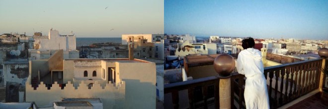
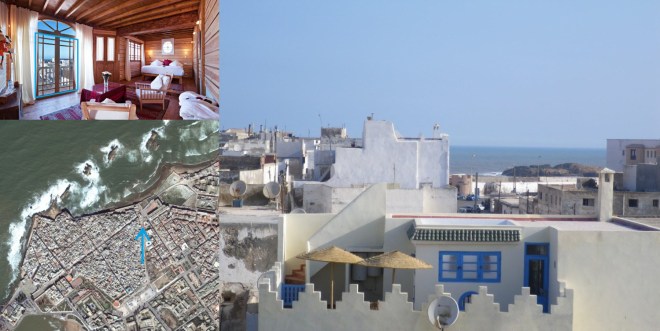
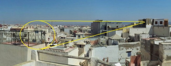
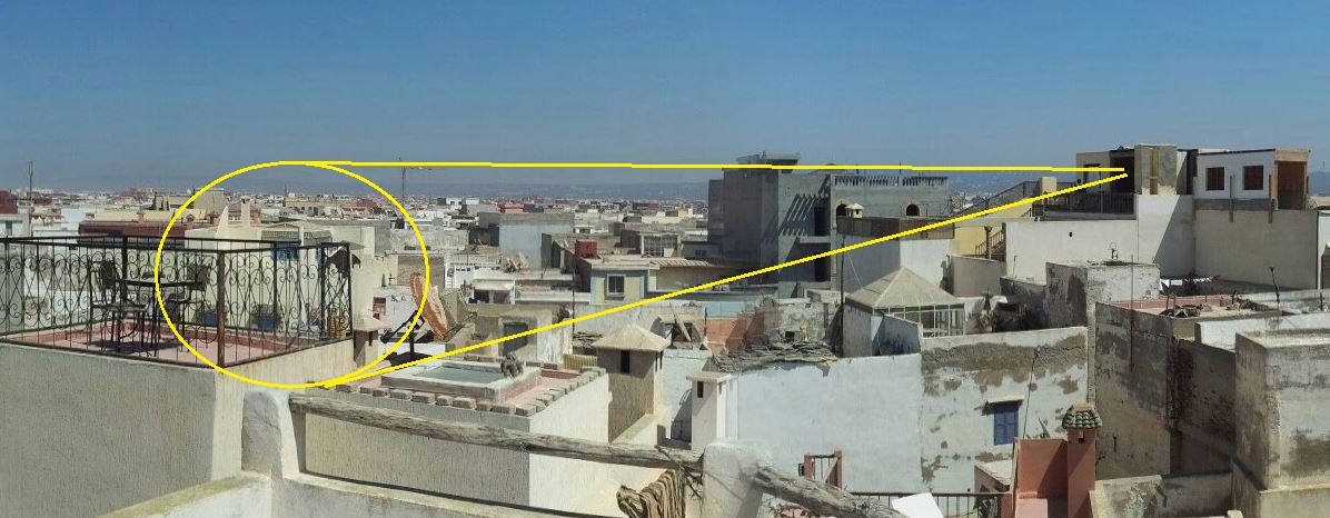
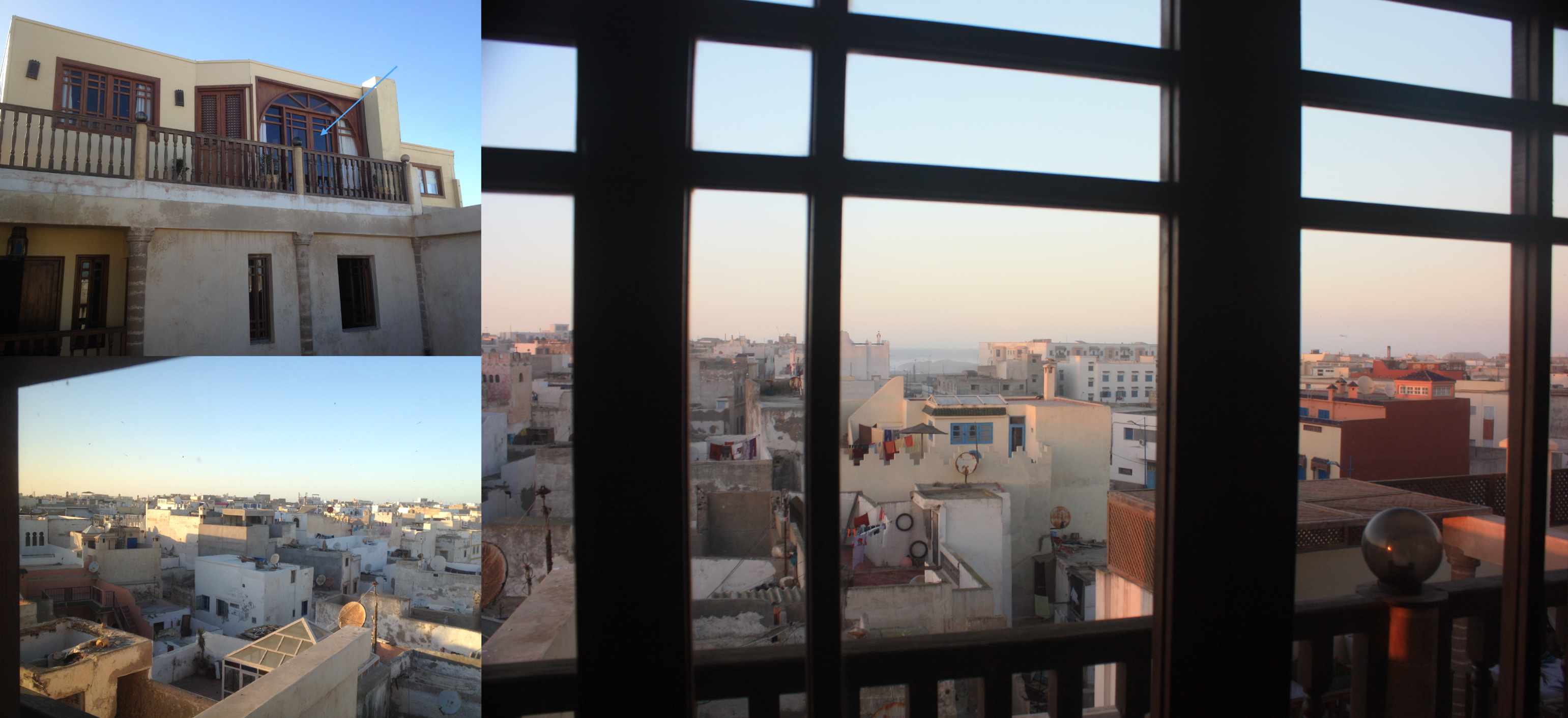
This week’s view comes from the old medina of Essaouira, Morocco. The picture was likely taken from the Chbanate Suite on the top floor of the Hotel Riad Chbanate, and looks almost due north along a heading of 352.08 degrees. Attached are an overhead view, a picture from inside the room, and a shot of the same view taken when the suite was just a roof terrace:

VFYW-Essaouira-Chini

Another star player also nailed it:

I was pretty confident that it was Morocco as soon as I saw the picture, but were it not for the long building close to the shore, I doubt I would have been able to pinpoint the town. This one is from Essaouira, Morocco, looking NNW toward the ocean. A rooftop panorama shows the unique building in the picture and where I think it was taken, which looks like it was under construction at the time:

ess_rooftop

I think it was taken from the Riad Chbanate hotel, from the Chbanate Superior Suite on the 4th floor – the website confirms that this suite was recently opened. The hotel is at 179 Rue Chbanate, 44000 Essaouira, Morocco. In the website’s photos of the suite and some traveler photos you can find the same view.

The tie-breaker goes to the reader who has participated in the most contests by far:

The photograph was taken from the Chbanate Suite at the Riad Chbanate, likely from the doors leading on to the porch. I was given a hint by a previous contest winner as to the city. His guess was off, but I found the rectangular building and worked back from there. Google Maps didn’t show much other than the Cinema Rif, which has a photograph online. And guess what? It’s visible in the window view, curved roof and all. (Finding old cinemas in the States on Google Maps by looking for curved roofs is an old pastime of mine; that site is very informative and shockingly poorly-designed.) Anyway, the nearest hotel to there is the Riad Chbanate (corner of Rue Chbanat and Rue Moulay Ismael), and the view from the Chbanate Suite (or perhaps the rooftop terrace, although it seems to lack windows) shows the same view as the VFYW submission, so going on the “these are usually taken from hotels” corollary, that’s where it is. (Also, this photo. And people seem to speak highly of the hotel on TripAdvisor.) Looks like a nice place to stay!

From the submitter:

Essaouira-window

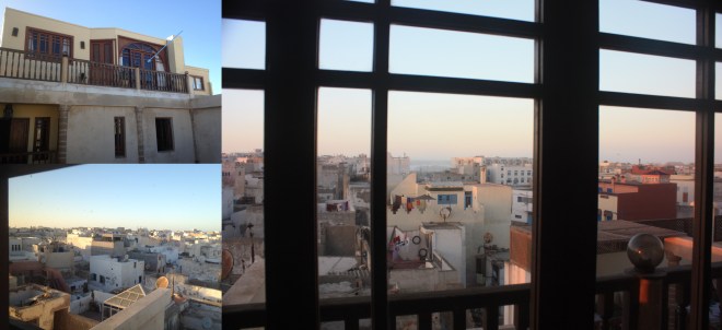
Morocco is a tough country for VFYW since most of the traditional buildings have windows looking out into internal courtyards and not into the streets, so there won’t be so many images of the right window. These photos were all taken a week ago from the same window in a room at the top of a small riad hotel in the coastal city of Essaouira. The hotel is called Riad Chbanate, has only 8 suites and is located just inside the fortified walls of the medina. The suite we had was a recent addition built on the roof and so very light with great views over the city skyline. The correct window: Chbanate Suite, 4th floor (5th US) of Riad Chbanate, 179 Rue Chbanate, Essaouira, Morocco.

Essaouira is only a couple of hours west of Marrakech and is a more laid back, welcoming place. Good for seafood, windsurfing and a mild climate.

(Archive)

The View From Your Window Contest

vfyw_1-4

You have until noon on Tuesday to guess it. City and/or state first, then country. Please put the location in the subject heading, along with any description within the email. If no one guesses the exact location, proximity counts.  Be sure to email entries to contest@andrewsullivan.com. Winner gets a free The View From Your Window book or two free gift subscriptions to the Dish. Have at it.

The View From Your Window Contest: Winner #185

vfyw_12-28

A reader writes:

The tall buildings side by side, vegetation and proximity to the water all suggest a hotel on the east coast of Florida. And if it weren’t for that island in the distance, I’d be pretty confident it is Miami Beach somewhere, maybe the Fontainebleu Hotel, 8th floor or so. My only hope is that most players are taking the Christmas week off and that this guess is in the right zip code.

Another:

Weathered concrete facades look like East Asia, probably South Korea. My guess is that it’s somewhere close to the southwest side of Haeundae Beach in Busan.

Another:

Seems obvious to me that it’s Vancouver, BC – the architecture, the fog, the water and the islands in the background.

Another:

I feel like I only write into this contest when it’s an Italian window. Call it laziness or a sureness in my convictions, but that’s what I recognize. Anyhow, this view looks awfully much like the view across the Bay of Naples toward Misenum from Pozzuoli, Italy. The vehicles in the look European in origin and I could have sworn (maybe my memory is playing tricks on me) that those apartment towers are in that city.

Another:

An Nahdah, Saudi Arabia? Another needle in a haystack picture. But I would probably do better if I didn’t get distracted by user pictures on Google Earth. This week I learned about Red Sea slugs and the country of Oman.

Another

Nha Trang, Vietnam? I’m probably wrong but I figured I would give it a try based on memories of being in the place. It looks like it’s outside of the main part of town, but the lack of motorbikes is what has me thinking I’m on the wrong track.

Another:

Long-time reader (and subscriber!), first-time VFYW guesser. Happy to see a familiar view. That’s the Aterro de Flamengo waterfront in Rio de Janeiro, Brazil, I think around Rua Machado de Assis. If memory serves, all that area past the buildings is landfill that moved the shoreline out (water used to lap up to where the buildings now stand). If you haven’t read it, Machado de Assis’ Dom Casmurro is a classic. The love interest is described as having captivating “eyes like the undertow” (olhos de ressaca), a phrase that always stuck with me.

Another:

From the Malecon Center building on George Washington Ave., Santo Domingo, Dominican Republic. I want to win that book.

Better luck next year! A family entry:

By now, my wife and daughter have both taken an active interest in this weekly VFYW contest. Generally, we’ll collaborate and come up with a consensus guess. Not this week. None of us spent a great deal of time researching our ideas (it’s busy holiday time after all), so our entry contains all three of our “gut” guesses. There are some bragging rights regarding who gets closest. The three guesses are Qingdao, China; Myeik, Myanmar; Canton, Equador.  As a previous contest winner, I’ll be getting some heat if my guess (the China one) isn’t closest.

Ecuador is the closest among those guesses, but the correct country is actually a little farther north:

My best guess is that this is taken from Calle Uruguay in Panama City, Panama looking out onto Av Balboa/Cinta Costera, the building on the right is the Hotel de Meridien, on the right just past this is the Club de Yates and in the distance is the Causeway. Taken in rainy season (although that makes up 9 months of the year!). Whoever took this will be enjoying the non-rainy, less humid, and slightly breezy time of year now. Other than the crazy taxi drivers, I wish they would have captured a Diablo Rojos for you!

Many readers correctly guessed Panama City, and several knew the exact building:

The view photo looks south from the Waldorf Astoria Panama located on Calle 47 Este in Panama City, Panama.  Lining up sight lines to the neighboring buildings from TripAdvisor traveler photos taken at the 7th-floor pool level and one from the 15th floor, I’m guessing that the view photo comes from the 12th or 13th floor. Let’s go with room 1320 just for kicks. From the 15th floor:

correct-guesser-panama-city

I admit to getting a bit lucky on this one; it could easily have taken up hours, but I found it, amazingly, in about 20 minutes.  The palm trees said tropics.  The shore showing a lower tide level along with the calm waters and heavy boat traffic said port/bay.  My first thoughts were maybe somewhere in the Caribbean, or Africa … so not too much to narrow it down.

I actually started with a Google search on “port city bay Africa” which returned a number of links for Port Elizabeth and Nelson Mandela Bay.  So that’s where the search began, halfway around the world from the actual view location.  I knew the distant islands/land mass with large buildings shown in the view would be a pretty good tell-tale.  Quickly I was zooming out my satellite map search beyond Africa and spinning the globe to check out the Caribbean … first Cuba, then Jamaica, then I moved over to Central America.  Panama came into view first, zooming into Panama City it all came together.

The twin islands, Perico and Flamenco, part of what I now know is the Amador Causeway, looked promising and I moved on to scanning the shoreline for the buildings shown in the view.  Soon I was plotting hotels, and the Waldorf Astoria proved to be the one.

Thanks for giving me a good diversion and a weekly nudge toward a self-imposed lesson in geography!  My wife has started ribbing me with Carmen Sandiego jokes for my contest efforts. I’m thinking next week I’ll have to get our three-year-old daughter in on the fun!

An aerial view:

unnamed

Another reader:

After years of reading the site, I finally got one. I recognized this immediately – and it probably didn’t hurt that I’m stuck in frigid Boston waiting for my Panamanian girlfriend to return from Christmas with her family. Their apartment’s view isn’t too far off from this one.

Another reader with ties to the country:

I have lived on and off in Panama since 1976, first for two years straight and then for month-long visits. I was last there from September to December, 2007. The changes to the urban fabric have been mindboggling. When I left, none of the waterfront highway extension – ciclovía, costera throughway, and parking lots – existed, nor indeed had their construction begun. Neoliberalism unbound produces a whole new cityscape of highrises that keeps expanding up and out. Happily the former US Fort Amador complex, once off limits for many years to all but a few US servicemen – and then to strongman Noriega and a few of the Panama Defence forces – is now open to all; and people throng there, especially on weekends. From it you have a view of a forest of high-rise towers across the bay that bids to eclipse Miami.

Another view from above:

panama city, bella vista

Of all the people who guessed the Waldorf, six have guessed correctly in previous contests without winning. Our winner this week just missed the right room number:

waldorfview
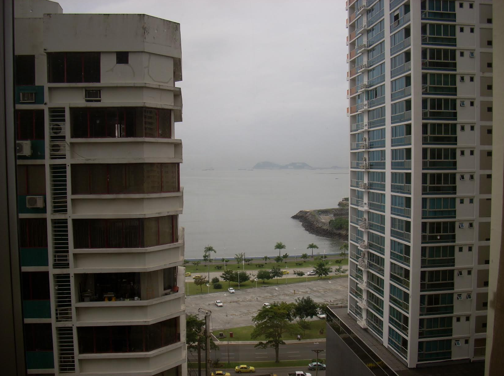
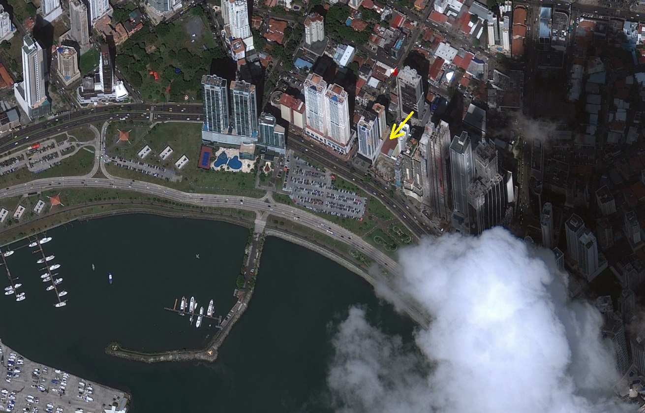
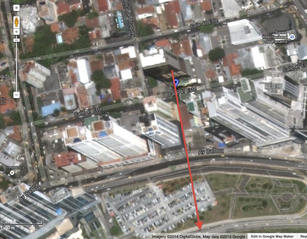
I think the picture was taken from the new Waldorf Astoria, at 47th and Uruguay St. The building seen to the right is the Villa del Mar apartment complex. Here’s a picture from Trip Advisor with almost the same view. Trying to guess a room/floor which would be easier with more ground-level images but I’m not finding any Google Street View available. I found another very close view a little to the right that was from 1211, so I’ll guess room 1209.

Have a happy New Year!

And a Happy New Year to all of our contest followers.  As a year-end bonus, we made a map of all contest entries from 2013:

Screen Shot 2013-12-31 at 1.15.19 PM

Zoomable version here. From the submitter of this week’s photo:

I’m a former winner (contest #73, Benghazi) and wanted to contribute for either the contest or just the regular daily view from your window. The picture was taken from Room 1207 at the Waldorf Astoria in Panama City, at the corner of Calle 47 and Calle Uruguay (there is no street number).

As for the story behind the photos, I’m nearing the end of an almost-around-the-world trip – I start a new job in January and quit the old one at Thanksgiving in order to give me some vacation time. I’m blogging about the trip here (my blogroll link to the Dish has hopefully resulted in at least a few new visitors to your site). I spent two minutes in North Korea at the DMZ, ran across some undercurrents of dissent in Shanghai (as well as a lot of non-religious Christmas displays), had a nasty ferry ride out of Macau, caught a piranha in the Amazon rainforest (where I came upon some remote oil installations), and had a few other adventures.

Even the VFYW grand champion, Doug Chini, missed the hotel room number; he went with 1212. But he was playing with a handicap this week:

I only had an hour or two of free time to search and I was fighting a toothache so strong that it had me squinting with my right eye closed. Pro tip: one-eyed-view hunting, not a good idea.

(Archive)

The View From Your Window Contest

vfyw_12-28

You have until noon on Tuesday to guess it. City and/or state first, then country. Please put the location in the subject heading, along with any description within the email. If no one guesses the exact location, proximity counts.  Be sure to email entries to contest@andrewsullivan.com. Winner gets a free The View From Your Window book or two free gift subscriptions to the Dish. Have at it.

The View From Your Window Contest: Winner #184

vfyw_12-14

A reader writes:

No San Jose-style giveaways this week, I see. We have a sea of McMansions in a relatively flat valley, mountains in the distance, and a cat. This could be any of a number of recent boomtowns in the American West. Or perhaps somewhere in Alberta. But I’m going to go with my first impulse, which was the outskirts of Las Vegas, specifically Henderson, NV, looking to the east. The terrain looks right and I believe they’ve had some record breaking cold lately (hence the dusting of snow). Hopefully the evergreen trees in front of a few houses are merely misdirection.

Another:

It’s been a long time since I’m made a guess, just because so many of the recent contests have been so damn difficult, but I figured I’d give this one a chance. Snow cover, relative lack of trees (particularly out in the distance past the development), large tracts of newly constructed suburban housing … it definitely suggests a city with a booming economy somewhere in the dry Mountain West. All the major cities in Utah and Colorado are immediately disqualified because the mountains in the background would be much, much taller. Billings, Santa Fe, Albuquerque, and Grand Junction don’t have the right kind of hills in the background. Boise is really the only city that fits all of the criteria, so I’m going with that.

Another:

I’m guessing this is Pocatello, Idaho. The mountains in the distance look very much like the area pocatelloand the town sits in a kind of bowl-like valley surrounded by them. How do I know Pocatello? I’m a documentary TV producer and I went through with a Pakistani crew and a host, who is “the Julia Roberts” of Pakistan. We went to meet and interview a pair of Pakistani immigrant doctors who live in Pocatello and have become local legends for their work in the community. That said, Pocatello is not the most exciting place in the world. Its main claim to fame is having its city flag voted the ugliest in the United States.

Seen to the right. Another reader:

With two holiday parties to go to today, unfortunately I don’t have time to look for the address, but that sure looks a lot like Tuscon. This picture nicely illustrates how that city looks like something straight out of The Martian Chronicles.

Another:

I give up. I’m stumped. I spent my entire PTO day yesterday trying to find this place and focused on Colorado and Utah with no luck. I figured the leaves off the trees and the new construction it was Denver or Colorado Springs or Salt Lake City.  Let’s go with Colorado Springs.

And I’m 3% sure the cat’s name is Mr. Phipps.

Update from the photo submitter:

HA! No. The cat’s name is Romeo:

photo 3(1)

The boy earned that named because he loves hard, guards the house against those slanderous squirrels, and is more than a bit impulsive.

Another reader gets punny:

Thanks to the huge spoiler in the photo this week. I want to be the first to state the obvious: this is obviously Kathmandu.

Another:

I have ceased to be amazed by people guessing these locations. That said, this one strikes me as nearly impossible.

It could be virtually any large subdivision in the American West (or even Appalachia, I guess, but I think not). I’ll guess a suburb southwest of Denver, call it the “Valley Enclave” subdivision of the neighborhood in Littleton, CO that is around 39.569771, -105.155785. Facing Southwest from somewhere around 30 Mountain Pine Drive.

Anyway, I also wanted to pass along my thanks for continuing to blog over the weekend. It must be taxing to post what is nearly 24/7. Wanted you to know it’s appreciated. Especially by a law student in the middle of exams who needs a distraction.

The Dish team is indeed indomitable. Another reader:

Nice picture. Lots of two story track homes, Western US style, evergreen trees in the front yards, relatively barren hills in the backgroun. Must be a large Western US suburb close to lower mountain ranges. Guessing Highlands Ranch or Aurora in Colorado, sitting next to the Southern Denver ranges.

It’s the former. Another gets it:

Fresh pow on the foothills … cookie cutter houses packed in like sardines … looks like Highlands Ranch, Colorado!

Another notes, “This is where the shooter in yesterday’s school shooting lived.” One of several schematics from an impressive reader:

fig1

A previous winner writes:

We’re looking at the eastern edge of the Rockies from the West Denver suburb of Highlands Ranch, which shares a zip code with Littleton, CO. In fact, Google Maps kept alternately telling me the address is in Highlands Ranch and Littleton. (And therefore near Arapahoe and Columbine – a news article on Friday’s shooting mentioned that a home in Highlands Ranch was searched.)

My dad immediately recognized Colorado, which is good because I probably would have started in Idaho or something. This image of HR I found helped a lot, as the mountains match the section found to the far right of the contest pic.

I think the picture was taken from [the correct address, redacted at the submitter’s request]. A vast scene of subdivisions is a nightmare! Different subdivisions have different styles so I could rule out several neighborhoods. We were near a corner on the left, and my best reference was the alternating pattern of rectangular roofs and asymmetrical roofs – see below. Note the approximate location of the cat seen in the contest pic:

roofs

Another previous winner also got the correct address and adds:

When I first saw this week’s view, I thought, “no, it couldn’t be, could it?” I grew up in the western suburbs of Denver (shout out to Lakewood!), and the sight of the foothills blanketed in fresh snow brings back many fond memories. Now a Minnesotan, I wish we had a little more vertical terrain to go along with the snow, ice and cold that keeps us company for a good part of the year.

Off I went to see if I could confirm this was in fact the sight of the same hills. It is amazing what you can do with two thumbs and an iPad! Scanning the 3D satellite images, I looked for the signature of the two well-defined ridge lines and the starkly contrasted southeast slope face that show up in the right third of the view.

After a few minutes working from Boulder south, I found what looked to be a match. Given the proximity and angles, I first thought that Columbine may be the town – fitting as a bookend to go along with the one-year anniversary of Newtown:

image

(Side note: it doesn’t seem right to me that the attackers – no mention of the victims – get their names listed alongside the place mark for Columbine High School on Google Maps – how can we change this?)

But the sight lines for the hills didn’t work for Columbine; instead it was clearly neighboring Highlands Ranch and its relatively new subdivisions that aligned.

Of the three non-winners who correctly guessed the exact address this week, one of them has participated in five times as many contests as the other two, so he wins the prize this week:

Between the look of the hills, the snow, and the sprawl, I immediately recognized this week’s photo as the Front Range foothills as seen from the southern Denver-area suburbs, looking southwest. I grew up in those hills just a little bit west of what you can see in the photo.

A couple minutes of scanning the foothills with Google Earth found the exact hills in the photo, then I moved NE until I saw some neighborhoods with houses facing the right direction and enough sprawl between them and the hills to be a potential location of the shot. The first neighborhood I checked wasn’t quite right, but the second was a match. I would consider this house to be a part of Highlands Ranch, but according to Google Maps, the address of the house is [redacted address].

And it wouldn’t be a window contest with a creepily accurate entry from Doug Chini:

VFYW Highlands Ranch Actual Window Marked - Copy

This one comes with a bit of deja vu. It was only last April that I was flying through the Alps near Rohrmoos looking for the distinctive mountains in VFYW #148, and now nine months later we get a similar search. Thankfully, this new set of peaks was much easier to find. This week’s view comes from Douglas County, Colorado. It was taken at [redacted address] in the Denver suburb of Highlands Ranch and looks southwest along a heading of 220.48 towards the Front Range of the Rockies. A best estimate for time and date would be December 9th at 8:33 AM (or perhaps December 5th). Attached is a marked bird’s eye view looking toward the mountains, an external shot of the window, and an interior view of the actual home office/alcove where the pic was snapped:

VFYW Highlands Ranch Interior Window Clean - Copy

The submitter of the contest photo wrote:

This is the view from my home office in Highlands Ranch, Colorado. We are in unincorporated Douglas County just south of Littleton. We were the focus of school reform this past election. We lost again to the conservative reformers.  But this is our home too and we’ll keep fighting for our kids and their teachers.

The Dish covered the school board election here. The submitter follows up:

Thank you for using my picture. To help narrow the win, if needed, the address is [redacted address]. Of course, this is a home address so please don’t publish. The view is looking west and a little south out over the western part of Highlands Ranch. Chatfield and Roxborough are between the window and the foothills.

A little more to add. I know the more urban of your readers will suck their teeth at this vast sea of suburbia. That is ok. I was that person too at one point. We’ve been here now for nearly ten years and I’ve never been happier anywhere else. When family from San Francisco or Seattle visit they wonder where the “there” is located. I laugh it off and kick rocks, but the truth of the matter is that this vast ‘burb is where my friends live. It is where my kids are growing up and it is where I fall in love my wife over and over and over again in between grocery shopping, car loops, and the rec center swimming pool. Besides, downtown Denver is like 20 minutes away for when we want to get all cultured up.

On a sad note, the most recent school shooting happened only eight miles to the north from where this picture was snapped. In fact, due to our intense feelings about the Douglas County School Board (oppose) and the reputation of Arapahoe High (top-notch), we tried mighty hard to get a house that fed to AHS. We failed in that endeavor. It is our sincere hope that the kids and their families at AHS will find healing and love in the days and years ahead. I wish there was more that we, that I, could do to ensure that nothing like this could happen anywhere again to any child.

(Archive)