A reader makes a snap judgment:
Definitely Las Cruces, New Mexico. I recognized the Organ Mountains instantly from my many trips to New Mexico State University for work. Don’t know where in town exactly, but given the new state of what looks like an apartment complex I’d say it’s on the north side of town just west of Interstate 25 where most of the new construction seems to be taking place. Best I could do in the three minutes before heading out the door …
Another also goes with his gut:
I haven’t done the research, but my first reaction to that flatness was somewhere in California’s San Joaquin Valley. I’m sticking with it. John McPhee wrote that the San Joaquin “outplains the Great Plains,” and Hitchcock transplanted a corn field to the San Joaquin, because no location in the Midwest was flat enough for the crop duster scene in North by Northwest.
The housing market has been brutal in the San Joaquin the past several years, and that apartment/condo complex looks new-ish, so I’m going with Merced, which is home to the University of California’s newest campus and maybe a little more resilient.
Another:
The place looks like the San Francisco Bay area, somewhere on the Peninsula. And the “lease” sign looks like it has area code 415 as its first 3 digits. Clearly it’s a US motel (you can see the building 2 sign), along with US stop signs. You’ll get at least 2000 replies saying SFO area.
Most of this week’s contestants did answer the same area, but not San Francisco. Another gets close:
Clearly American Southwest (American because of the double-yellow line in the lower right hand corner, and Southwest because that’s the only place in America that looks like that). At first I was thinking someplace like Henderson, NV, but I think there are more mountains near Las Vegas. Tucson, AZ is the closest of any place I’ve been to resembling the location.
Arizona it is. Another recognizes the city:
After the renewal countdown started appearing on the Dish, I should have expected an obvious ploy to woo my re-up with an easy VYFW contest shot of a neighborhood in my metro. I have neither the skill, time nor patience to search Google images and maps for the exact spot but it looks like southeastern Phoenix to me. Pretty sure that’s Piestewa Peak in the mountain range in the background which is not far from my house.
Alright already! Rest assured my renewal will be forthcoming.
Another notices the main hidden clue for this week’s contest:
Go Tigers!
Another elaborates:
This is totally exciting for me to send this. I love the VFYW contest but they’re always so difficult.
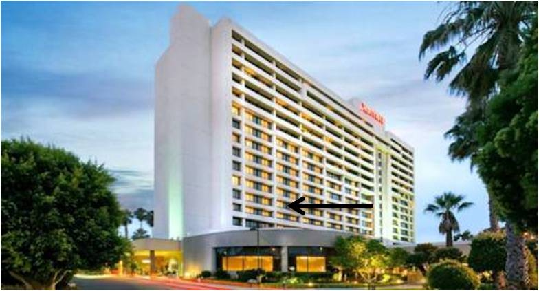
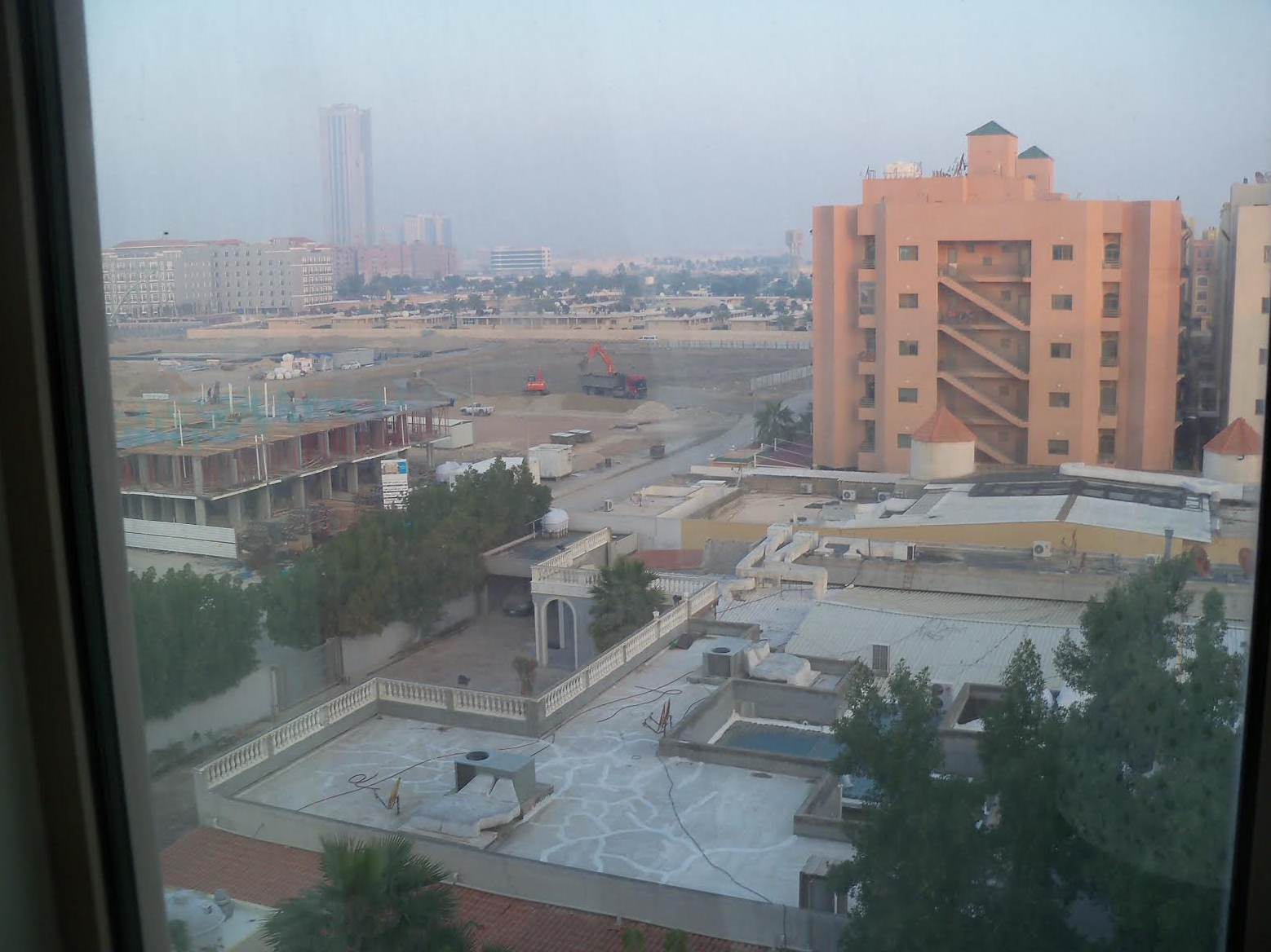
The picture immediately reminded me of how it looks in Arizona. I live in Sierra Vista (not far from the Mexican-American border) which is several hours from Phoenix, but it’s looks pretty similar. The view is from the Phoenix Airport Marriott hotel in Phoenix, Arizona. The sign by the road is “Balsz Tigers” next to the Balsz Elementary school located at 4309 East Belleview, Phoenix, AZ 85008. The hotel is at the corner of E Moreland Street and N 44th street.
I know I won’t win. I know people will send exact floor and window of the hotel, but I don’t care. It’s quite awesome just to send this in for the first time.
And an awesome visual. Another is also just thrilled to be a contender:
One of my FAVORITE parts about the Dish is the VFYW contest, and one of the reasons I renewed my subscription last week was so I could keep seeing the fascinating entries – but I am so excited to send in my FIRST guess! I am sure you are going to get a million entries for this one, since the “Balsz Tigers” is Google-able to Phoenix, Arizona, and the airport Marriott is right there. I’ll guess the sixth floor of the Marriott at 1101 North 44th Street, Phoenix, AZ, and leave your insanely skilled readership to beat me by choosing the room
How fun, thanks for throwing us an easy one! (Now I really hope I’m right and not in the dreaded section above Read On …)
The very first guess we received this week:
Omigod! Okay, I’m not going for the win by figuring out where the hell is the tall building near the Papago Gardens condo complex in Phoenix because I just want to get this in before anyone else does. The elementary school across the street is called Balsz. Yes. And their slogan is “Believe in Balsz … Balsz believes in you!”
Other readers question our motives:
Pretty balszy (or lazy) of you.
Another:
Did you want to see how many people actually play?
461 this week. But the Green Line in Brookline is still our most popular contest ever, as far as entries. Another reader:
Is it some renewal marketing effort or have the pictures from Equatorial Guinea or some sparsely populated Swiss Canton stopped coming in?
Challenging-but-not-too-challenging views have become really scarce in the in-tray, but once in a while it’s good to throw a really easy one in the mix so most people can participate. Another reader:
I see from GoogleMaps that this shot is taken from an upper floor window of the Phoenix Airport Marriott hotel, but I haven’t a clue how to do the trajectory calculation to find the exact window. Kudos to the techies who are masters at this sort of thing. Thanks for throwing a piece of low-hanging fruit to those of us who otherwise despair week after week. Know hope indeed!
And fun for the whole family:
My nine-year-old son has taken an interest in the VFYW contest and this one was easy enough that I could coach him through the steps. While I recognized it as Phoenix right away, I walked him through the steps (plants suggest desert, looks like American city, etc.). He found the “Balsz Tigers” sign and was able to locate the school in PHX using Google. Little bit harder to get the “taken from” concept but the whole experience was fun for him. Later in the morning I heard him quizzing his younger sister about the puzzle and explaining the clues.
Another channels her inner grand-champion:
This photo is taken from the Phoenix Airport Marriott, 1101 North 44th Street, looking northwest. I’m guessing the 12th (i.e., top) floor. Alanza Place Luxury Apartments in the middle of the photo; Balsz Elementary School off to the left – how nice of them to put up a sign for their team!
Given the HUGE clue right in the middle of the photo (maybe it was chosen after a very long day of working on renewals?), I’m sure you’ll have hundreds of correct answers. Maybe that should reduce my excitement level about identifying a View, but I’m still utterly thrilled. You once ran one of my photos (Contest #144) and one of my (incorrect) guesses, but my VFYW footprint is otherwise non-existent. I toil in obscurity. Sometimes I get close; (I guessed Germany last week); more often I’m on the wrong continent.
Until today. This is as close to a Doug Chini moment as I’m going to get, and I’m savoring it!
Speaking of Chini-like triangulation:
Tricky. Google Maps doesn’t have the Balsz Tigers art in the fence, but there aren’t many Balsz Tigers in the world to Google. I’d say it’s from one of the top floors (9th?) from how steeply it can look down on the neighboring buildings and from near the convex part of the building from what was included in the photo.

Another reader knows the area well:
Having lived in Phoenix during my teens I instantly recognized the sharp profile of Piestewa Peak on the horizon, a popular scramble for local climbers and hikers. (We knew it then as Squaw Peak before it was renamed in honor of Lori Ann Piestewa, the Hopi woman who was the first female casualty of the Iraq War and the first Native American woman to die in a US military combat operation)
Another notes:
Piestewa Peak was named after Lori Piestewa, the first woman to be killed in action in the war in Iraq. She was taken as a POW along with her best friend Jessica Lynch but unfortunately died from the injuries she sustained in battle before she could be rescued. It’s good to remember those who served.
Another sends the best visual entry this week:
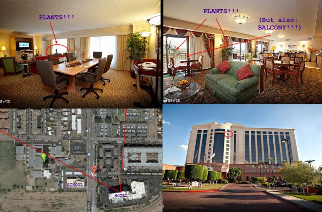
I’m terrible at guessing heights and room numbers, but I’m going to go with room 1105 – possibly a business suite, a photo of which is attached as BusinessSuite – since those are the only rooms I can find on the Marriott website that show plants in the rooms. (Well, those, and the concierge suite which seems to be on a lower floor and features a balcony.)
Another reader has stayed at the hotel often:
This week’s VFYW is taken from the Phoenix Airport Marriott, located at 1101 N 44th St in Phoenix. I’ll guess its taken from the seventh floor. I’m not sure of an exact room number this week, as I can’t find any posted floor plans of the Phoenix Airport Marriott, most likely due to the fact that it’s an airport hotel and security precautions preclude them from posting photos that might give potential wrongdoers a leg up. I’ve actually stayed there several times in the past, as this was a hotel my former employer used for conferences when I was still working. If only I’d known that eight years later I’d be playing an addictive detective-type game that required a detailed floor plan in order to MAYBE win, I’d have held onto the map that they gave us through my cross-country moves. (If only I was joking …)
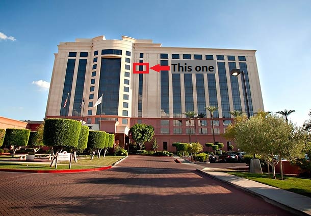
Another gets painfully close to the right window:
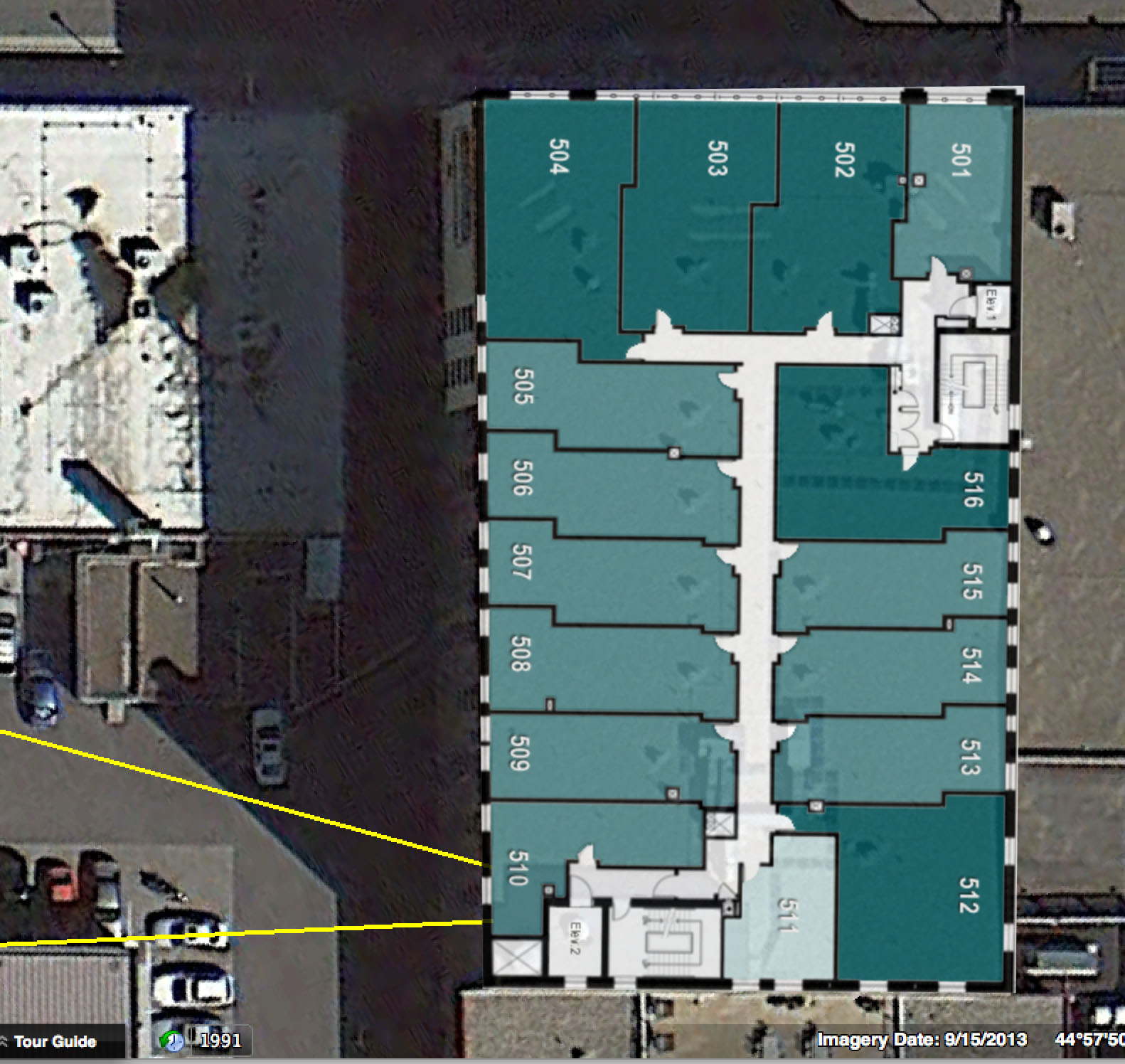
The window looks skinnier than most of those on the front of the hotel. Based on the angle of the hotel compared to the street, it doesn’t appear to be one of the smaller ones on the half-moon extending out of the left side. Therefore, I’m guessing it has to be one of the very skinny windows just to the right of the half-moon. Since those windows are, in turn, right next to a section of the facade without any windows, I’m guessing these windows are for guests waiting for the elevator. Some eyeballing the distance from the top of the building across the street to the horizon, I’m guessing the 10th floor, but I’m not too confident about that. See the attached image in case my description is not sufficient:

A Phoenix native was tempted to head down to the scene:
I recognized Piestewa Peak right away (formerly known as Squaw Peak), then used the antenna in the distance to figure out that it had to be taken from the airport Marriott on 44th St and Belleview in Phoenix, AZ. As that’s only about a mile from my house, I considered getting in the car and going there to figure out the room. Then I realized it’s the weekend, so I opened a bottle of wine instead. Totally bookworthy.
One more:
There’s no way on Earth I can win this one, since the “BALSZ TIGERS” sign is going to completely give away the location and people are going to spend hours triangulating the exact position of the window in the Phoenix Airport Marriot. Of the 1000+ entries that guess that much correctly, I’m assuming that 300+ will get the correct room. Of those, 100+ will guess how far the photographer was standing from the window, 50+ will know the species of house plant blocking the view, and 5 will somehow deduce the photographer’s blood type. The winner will be the one who did all this successfully 83 times without winning.
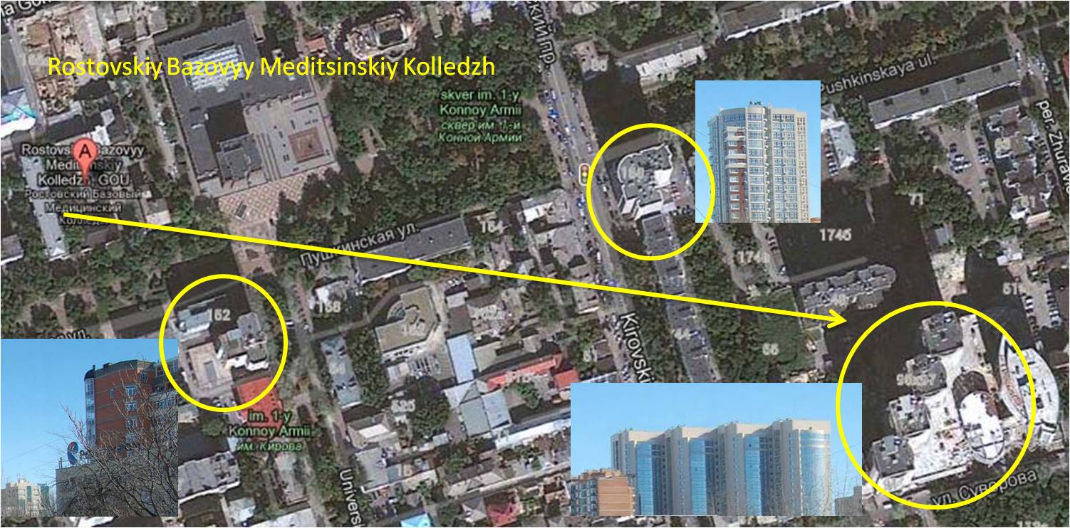
Indeed, this week’s winner has correctly guessed numerous previous contest without ever clinching the prize. His detailed entry:
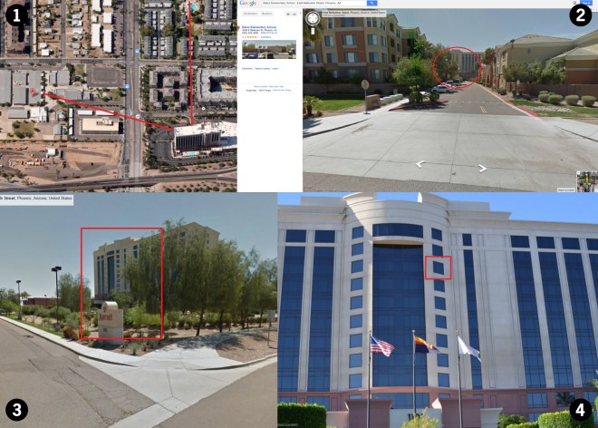
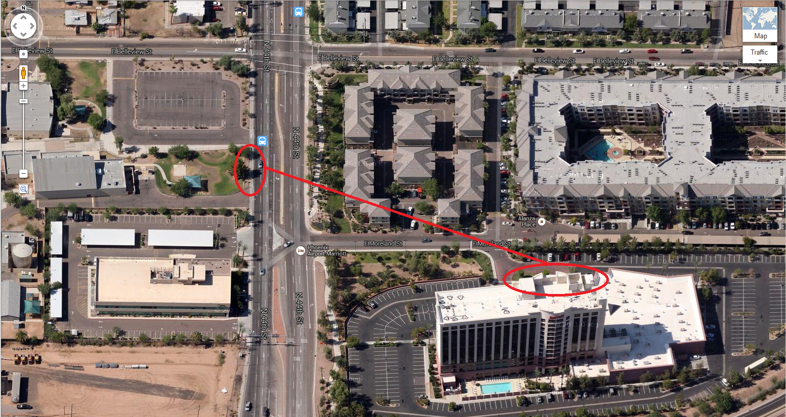
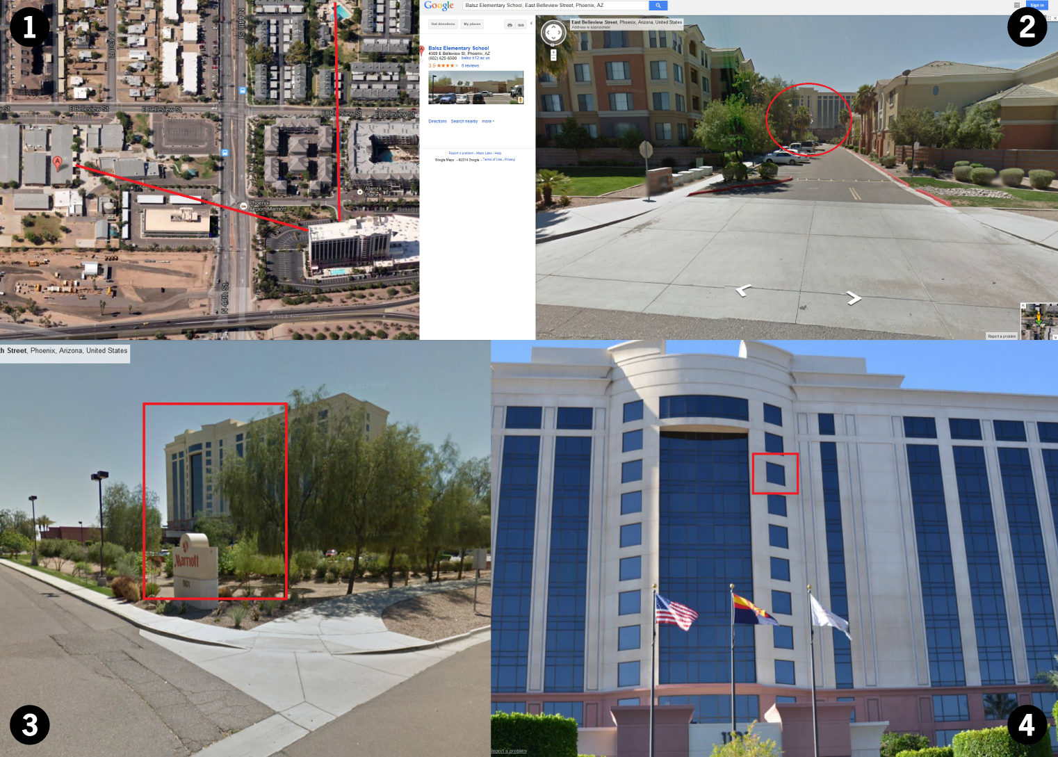
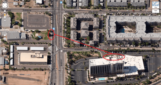
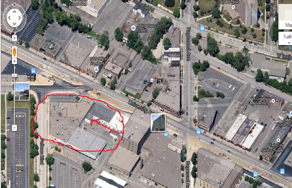
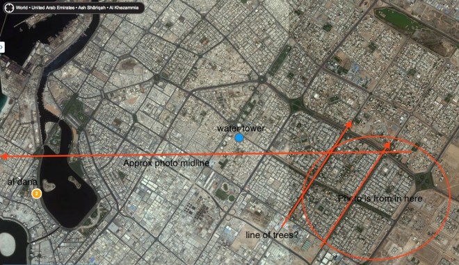
This one was too easy. The Balsz Tigers banner is easily visible along the major thoroughfare, so a Google search for that turned up Balsz Elementary in Phoenix. When you look at that in Google Maps, it’s clear that Balsz Elementary is the building in the left of the VFYW, and the picture is taken from the Marriott. (See image #1 for the range of the view shown in the VFYW.) So this is going to be an issue of getting the right picture.
A view from the other end of the side street visible on the right in the VFYW makes it clear that the center of the Marriot looks slightly different. (See image #2.) A view from N 44th Street, basically a reverse of the window view, confirms that the near windows of the center part would fit the picture. (See image #3) Although the hotel is positioned at an angle to the street, the VFYW seems to be even more angled, indicating that the windows facing more toward N 44th Street would fit.
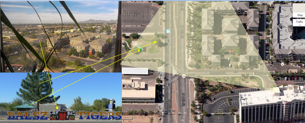
Then it’s an issue of which floor. I honestly have no idea, so I’m just guessing the window I’ve indicated in image #4, attached.
The submitter of the contest photo verified the exact window for us and added:
I was there for a science fiction convention called Dark Con that featured Adrian Paul of “Highlander” and world-famous science fiction author Gini Koch. After I noticed this week’s contest was based on my photo, it took great restraint on the part of my best friend to keep him from entering. We play every week. I even bought him a Dish subscription to make it easier!
Many thanks to the hundreds of contestants this week, most of whom were playing for the first time. And don’t worry, next week will be much more challenging!
(Archive)


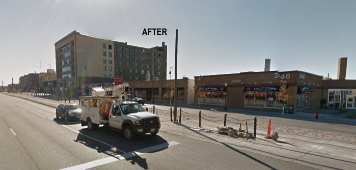
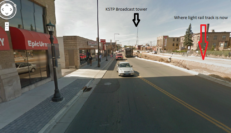

 There are two towers at these coordinates: 35 45′ 48.00″ N 51° 22′ 25.84″ E that sort of resemble the one in the photo, but thanks to massive economic and political sanctions and highly suspicious Iranians, there’s no Google Street View to confirm. I don’t even know what those buildings are. The image I found