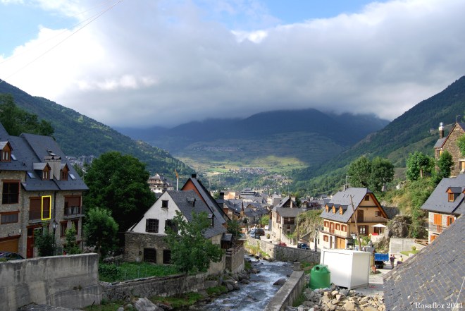
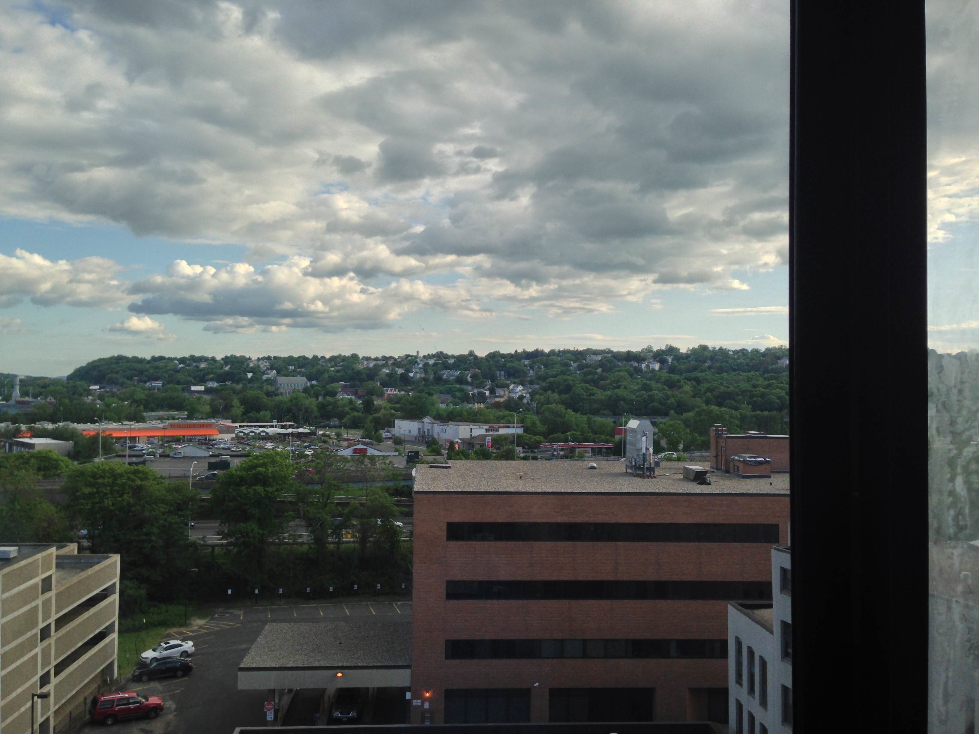
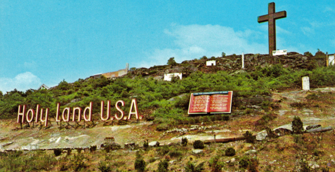
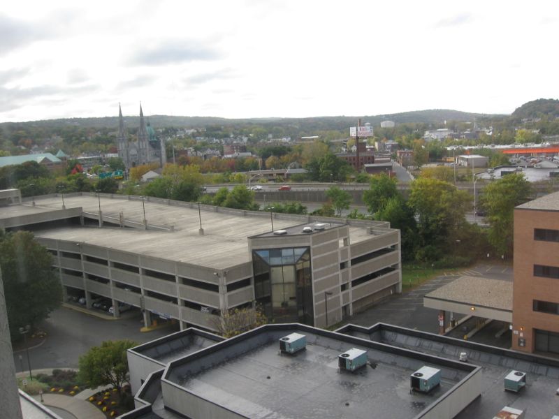
After more than four years running the VFYW Contest (a feature increasingly innovated by Chas, aka Special Teams), I thought I would finally throw my own view into the ring. A reader writes:
Somewhere in Barcelona. I had a very similar view from a hotel there once.
Another:
Paraguay, because of “Chacarita” on the bus. (Chacarita is a barrio, or neighborhood, in Asunción, the capital of Paraguay.)
Another asks, “How about Chacarita, Costa Rica?” Another stands by his principles:
SW Rome. I don’t believe in researching these!
Another notices a key detail:
Winter clothing and the portable propane patio heater tell us we are looking at the Southern Hemisphere.
Another gets the right city:
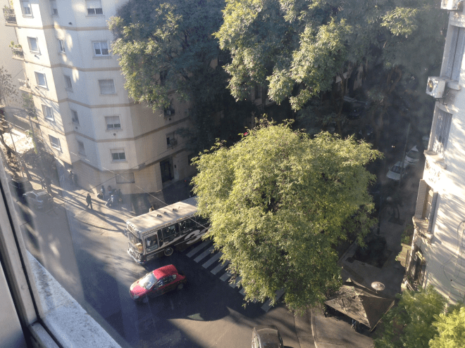
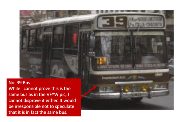
Unless I’m missing something, this one had a surprisingly HUGE giveaway: the graphics on the bus – Chacaritas – clearly place the photo in Buenos Aires, Argentina. I’m putting it in the Colegiales neighborhood on Calle Maure, but being an underachiever with three kids in tow to boot, I’ll leave it to another Dishhead to take this one home!
Another shares a great memento:
A few years ago, my family went on a vacation to celebrate my dad’s 60th birthday in Buenos Aires, the location of this week’s VFYW. This photo transported me back on Sunday morning when I saw it, with its architecture, foliage and of course, the bus. While there, one souvenir I purchased was a small coffee table book, El Libro de los Colectivos, a book celebrating the unique styles and culture of the city’s buses:
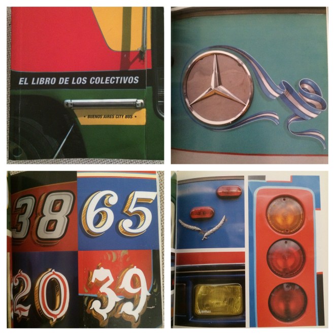
The colectivo 39, without a doubt, is the major clue in his week’s photo (although according to the book, number 39 seems have have changed its look since this book came out). Looks like it used to have a red and black color scheme, different than today’s mud and cola colors. Both still have gold accents.
Another goes for the right neighborhood:
After hoping that someday there might be a VFYW pic with a clue so obvious that it might as well have been written on the broad side of a bus, there it was, right in front of me. But I’m still uncertain. I’ll go with the neighborhood of Chacarita in Buenos Aires, Argentina. More specifically, a view from the Hotel Torre at the corner of Avenues Corrientes and Olleros. Late afternoon Southern Hemisphere fall shadows agree with that intersection’s orientation, but there is still something not quite right with the hotel’s location at that corner. But I will stand firmly in quicksand with my guess.
Another adds, “The famous Chacarita Cemetery is the largest cemetery in Argentina with many notable interments.” Another reader:
Gut feeling says “Buenos Aires.” I was there a couple of years ago and this looks like the neighborhoods I walked through. I won’t go for the intersection (let alone the exact window), but let’s say it’s in the Recoleta neighborhood, near the cemetery where Eva Peron is entombed.
Another notices a detail no one else did:
The jacaranda trees and architecture told me it was Buenos Aires, probably the Palermo neighborhood, before I even tracked down the bus that features so prominently in the photo.
Palermo it is. Another reader:
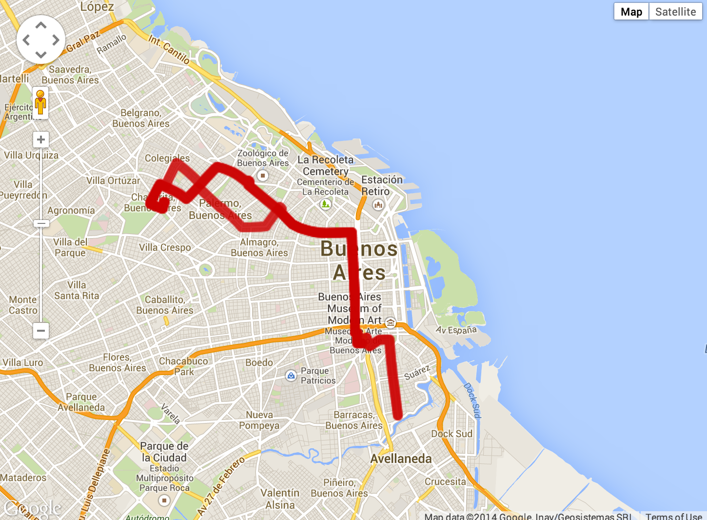
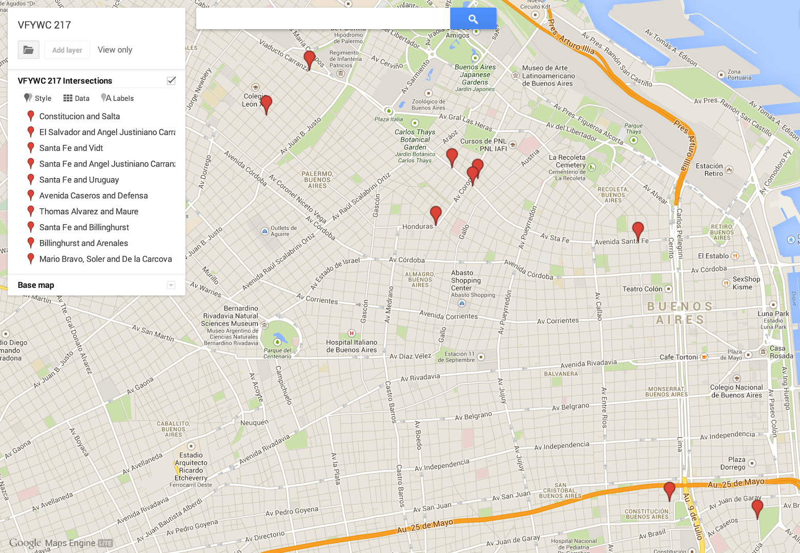
Welp, everyone is going to get this week’s window location, I think. Googling “chacarita 39” brings up this route map for the bus in the picture as the very first hit:

If I were motivated to find the exact window, I’d just take that map and – noting that the bus is turning right – find all the right turns on the route and zoom in on them. But I’m not, because thinking of Buenos Aires reminds me of my favorite author, the master Jorge Luis Borges (who was born there), and I find a parallel between the VFYW contest and his tale of the Zahir: that thing that possesses the power to induce an overwhelming obsession in those who see it, slowly consuming them until they lose all sense of reality, until finally “(they) will have to be fed and dressed, (they) will not know whether it is morning or night, (they) will not know who (they were).”
Many are the Saturdays that I have spent long hours seeking out the location of a fascinating View window. Is it possible that this contest has become my Zahir?
Another moves along:
If you think I’m going to follow the 39 Chacarita bus line through it’s entire route looking for this corner, you’re nuts.
Another gives it a shot:
I’m not super familiar with Buenos Aires, but based on the fact that the bus is turning right and on the tree-lined street, I’m guessing Avenida Santa Fe in the (trendy!) Palermo district, taken at the intersection of Santa Fe and Vidt. From a 5th-floor window in the building on the northeast side of the street.
Another tried another tool:
So, I’ve chased every turn the #39 Chacarita bus makes as it winds through the streets of Buenos Aires and failed miserably. Even tried searching through the photos of each hotel listed on the route in the Time Out guide. I’m exhausted and my head hurts!
Chas helped me plot many of the other guesses:

Another scratches his head:
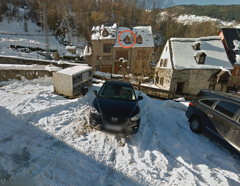
I thought the geometry of this intersection was peculiar. There were three vehicles in motion at this intersection. The photo shows that the vehicles are traveling on a one way street. The vehicle to the right (in the photo – it is left in relation to the other vehicles in the real world) is making a left-hand turn, while the bus and the car next to it are going straight through the intersection. To the left are parked cars facing the opposite direction from the car turning left, which indicates that this street might be two ways.
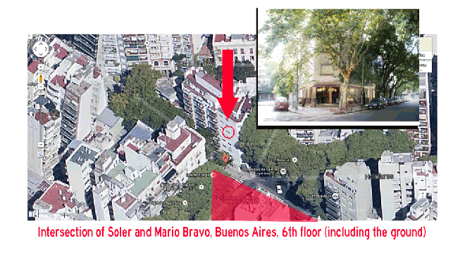
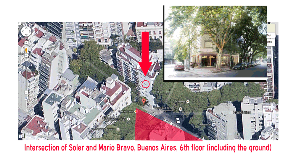
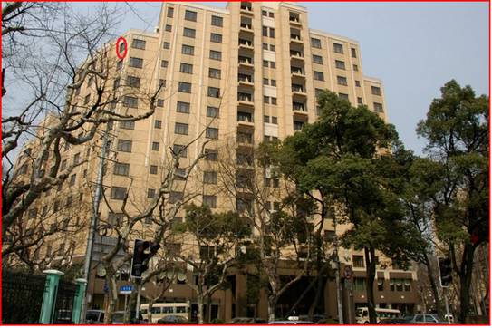
Another nails the right intersection:
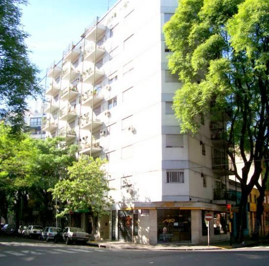
First-time entrant, long time astonished observer here. I think this was taken from the fifth-floor window (fourth-floor in European counting, i.e. ground+4) of the building on the corner of Mario Bravo and Soler in Buenos Aires (3600 Soler? Can’t figure out an exact address), on the five-way intersection of Soler, Honduras, Mario Bravo, and Coronel Diaz.
Another provides a visual of the five-way:
The #39 bus to Chacarita! Google search for “Chacarita” led me to Buenos Aires, and from there I found a detailed route map of the #39. So I just have to use Street View to check out all the intersections on the route where the #39 bus turns, right? Wrong – there’s no Street View for Buenos Aires yet. But Google Earth is a good enough substitute, and it led me to this intersection:
The photo looks like it was taken from the triangular building on the south side of Soler, and the photo is catching the bus turning onto Soler from Av Coronel Diaz. I couldn’t find the address for the building where the photo was taken, so I assume it’s residential – I’m guessing the window is on the 6th floor of the building.
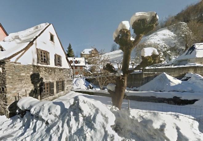
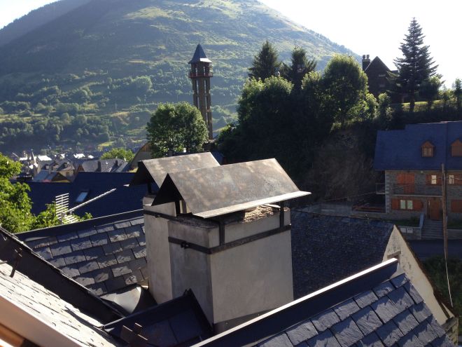
Another has a great photo of that triangular building:
My city! Finally! At first sight, it looked like the snobbish Palermo neighborhood. With the 39 line bus clue, and the street that changes its direction (Soler Street), it was a piece of cake to deduce the exact corner. I know this city better than my palm. It’s a similar size to NYC, and it does have a somewhat similar vibe, but it has fewer green spaces (in that sense, it is the worst in Latin America) and a worse public transport system. It’s a worse city than New York, but I love it.
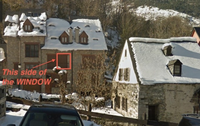
This was the building in which the picture was taken, and I’m guessing the fifth floor:

Another walks us through:
The two-steps-forward-and-one-step-back of this week’s contest:
1. Easily spot Chacarita 39 on bus in picture… Yay!
2. Note that this damn bus line in Buenos Aires runs through pretty big portion of the city… Grrr
3. Easily find a block-by-block bus route on a satellite image-enabled map… Yay!
4. Waste precious time trying to find a spot on the route where the bus turns sharply right… Grr
5. Using both the bus line website and Googlemaps, locate the slight turn (a right turn!) on from Avenida Coronel Diaz, across Soler, onto Honduras that appears to fit the bill… Yay!
6. Realize that Google Streetview is not avialable in Buenos Aires… WTF?!
My best guess is that the picture was taken from an apartment building with the address “De la Carcova 3501-3599” in the Palermo section of Buenos Aires. The view looks due north from the fifth floor across Soler towards Avenida Coronel Diaz.
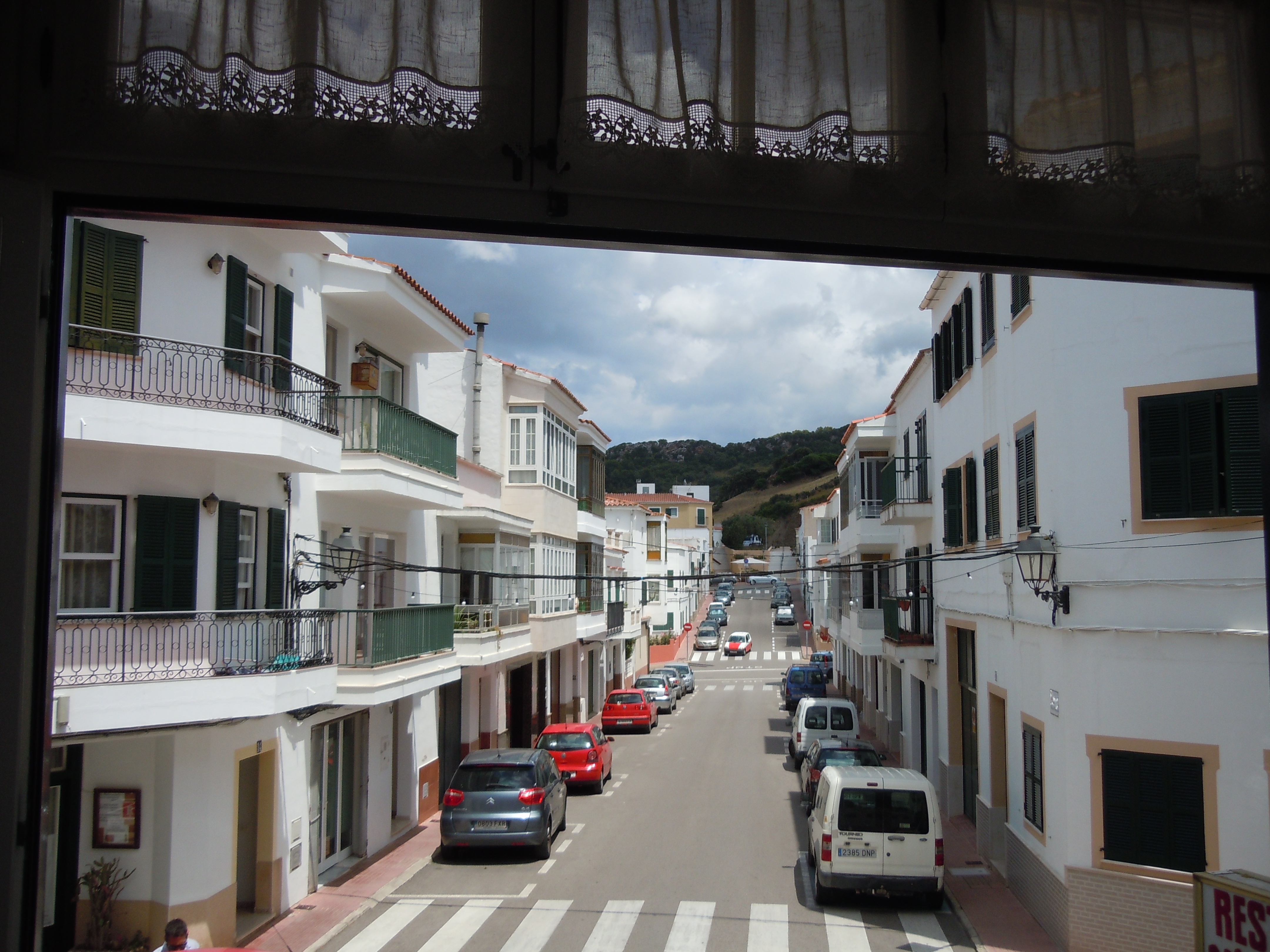
One of the best visual entries:
Another didn’t get that far:
Looks like a South American city. Somewhere I’ve been. Best guess: Buenos Aires. It may be winter there, but it’s a gorgeous summer day here, so I’m done. (I’ll leave finding the details and winning the book to someone else.) Gonna go out and enjoy myself in Central Park, in that wonderful city that you hate so much and that apparently makes so many people so miserable.
Rest assured there won’t be any gratuitous NYC bashing while Andrew is away this month. And by the way, the winters down in Buenos Aires are pretty gorgeous too; 65-degree sunny days are common. How a reader describes it:
It’s a strange place: Warm as hell but resembling a German city at times.
Another:
It turns out it’s actually more frustrating when you know the city! I have spent a lot time in Buenos Aires so I knew immediately. I suspect I’ve even taken the Line 39 Chacarita Bus. If I were a more patient individual I could trace the route of the bus but I’m not that patient. Anyway, I’m guessing somewhere in the Palermo neighborhood. I await the efforts of a more obsessive person to identify the exact corner, and window.
Another obsessive:
Another notes:
Riding those buses years ago was one of my highlights of living there. Drivers would “drive,” shift gears, smoke, talk to their girlfriends (seated behind or next to them), give tickets, make change, yell at passengers, debate passengers, and, usually, avoid minor fender benders with other vehicles and pedestrians.
Another also knows the area:
The #39 bus to Chacarita (a fabulous neighborhood where many gays have moved since the gentrification of Palermo) veers right at this intersection onto Calle Honduras. Hope I’m right! And I hope the “rational default” doesn’t further destabilize an already highly volatile economic / employment situation in Argentina.
Another has fond memories of the city:
I spent six months studying in Buenos Aires while I was in college and lived in the Palermo neighborhood with a lovely old couple, and I woke up to a similar more often than not. After I got married last year, I traveled there on my honeymoon where I tried to relive some of the magic of that city. Now, the number 39 route (which I did ride on occasion) goes through several neighborhoods, but the feeling on the street reminds me of Palermo. Thanks for reminding me once again of this great place.
Another:
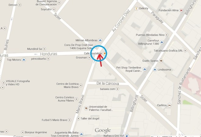
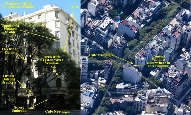
It’s a tremendous coincidence that you selected this precise location, since it not only inspired great nostalgia in me as a former resident of Buenos Aires, but in fact the lower-right corner of the photo contains a view of Café Nostalgia, located at the corner of Av. Coronel Díaz and Soler in the neighborhood of Palermo.
My nostalgia was further enhanced by the fact that I used to live about ten blocks away, on the border of Palermo and Recoleta, and that I used to ride that very bus (the 39 Line to Chacarita) with great frequency while attending classes in the Faculty of Social Sciences at the University of Buenos Aires.
Great choice – thanks for the wonderful memory!
Another adds, “Café-Bar Nostalgia is described here as ‘a space in which you can revel in the antiquated whilst observing the modern,’ complete with a crowd-pleasing ‘barrelful of monkey nuts’ – yum!” … meaning a barrel of peanuts from which they serve you a bowl at your table. Another reader:
The neighborhood sounds interesting and perhaps a bit ritzy. A review of the restaurant across the street gushes about the $35-$40 main courses and the excellent people watching.
That review was written in January 2010, and prices at Cafe Nostalgia are actually much lower now. I’ve had many amazing steak dinners there with another person, sharing a bottle of wine, and I’ve rarely spent more than $50 USD. Update from a reader:
By the way, if you want a fancy (somewhat expensive by BA standards) and amazing meal, try Paraje Arevalo. We went late last year and loved it.
Just the kind of recommendation I was hoping to get by posting my view this week. And I’m finally getting a two-week vacation this month, after many years without a break from the Dish longer than a week, so keep the recommendations coming! My favorite entry this week:
I recognized Bs As right away – same as I did last time you had this city: there’s something so distinct of its aesthetic. I used to to live there back in ’09-’10. I googled the bus line and that confirmed it (as recently as 2010 there was no website like that and you had to carry around a city-issued byzantine pocket-guide). Out of the path on that route it felt like the neighborhood of Almagro to me.
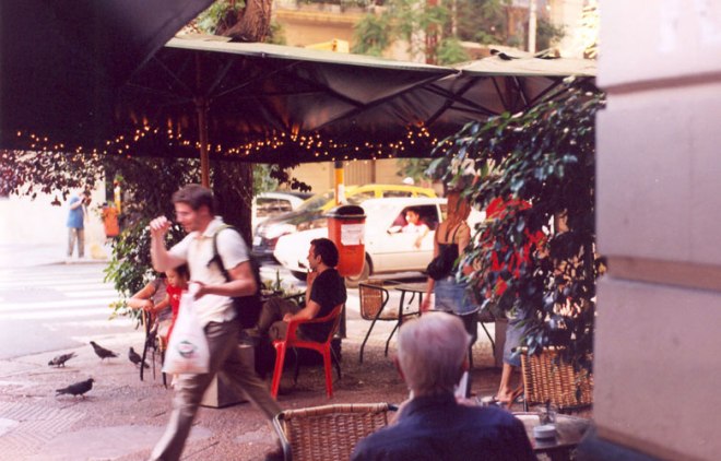
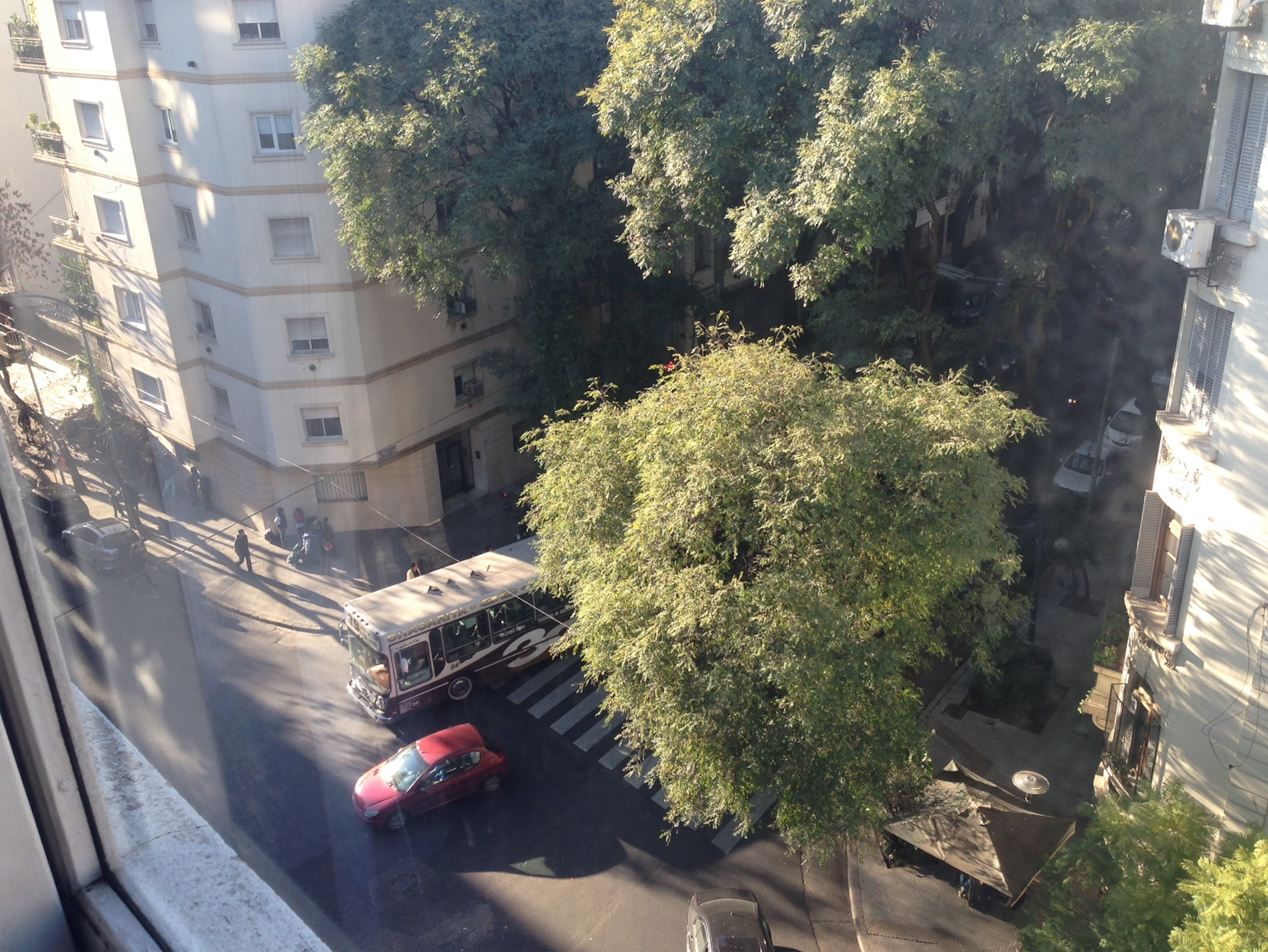
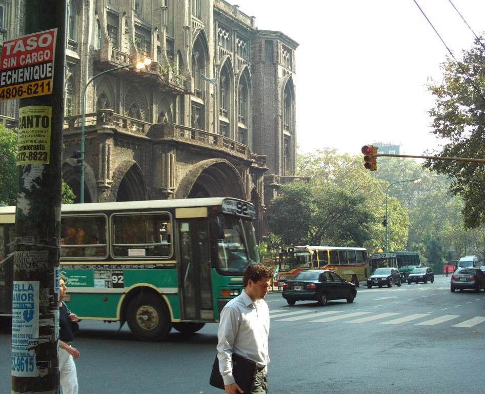
I started looking along “Honduras” and when I cam across the corner of Colonel Diaz I saw “Cafe Nostalgia” pop up. Back in Bs As I worked part-time as a photographer for The Argentina Independent, a small English language newspaper. I’d photographed Cafe Nostalgia for them as part of a project on the then-54 Bares Notables (bars and cafes with a sort of historical landmark status from the city). Two of my photos [seen above and below] still come up as some of the first google image results for “Cafe Nostalgia.”
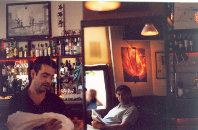
I went back and looked through the rest of that roll (all film) and even though there wasn’t any smoking gun pic, I do think that that green awning in the bottom right is Cafe Nostalgia. Maybe it’s just wishful thinking for this whole coincidence to be the case, but I’ll make my guess for that corner: Universidad de Palermo – Ingenieria, Mario Bravo 1300, Almagro, Buenos Aires, Argentina. Let’s say 4th floor.
Truly an amazing coincidence that the photographer is a Dish reader, since his photos were widely cited by other players this week. Another:
So easy!!! Since this is my hometown :) The giveaway was the bus. The “39”. Anybody who has ever visited BA knows that the city is crowded with buses everywhere, each with their different numbers and their distinctive colors. The 39 passes by my old school (University of Buenos Aires) and of course I took it many times to go places in the city. The “Chacarita” written in the top of the bus signifies the last stop, one of the biggest cemeteries in the city. So I’m guessing that you will get tons of correct answers this week. I can’t give you the exact window but it doesn’t matter, it was definitely nice to see my city in the contest this week, I really miss it. “Mi Buenos Aires querido”.
Another also reflects:

Identifying the city was easy. I went on holiday to Buenos Aires with friends in 2008, and I snapped a street scene in the containing buses with similar numbering, attached here, which helped me identify this photo location. The distinctive multi-story European architecture and signs in Castilian Spanish were also good clues.
Another wants to go:
I came across the El Ateneo book store while googling along the route 39 bus line and then stopped searching as I didn’t want it to be anyplace else. Beautiful. Thanks for adding another location to the bucket list!
Another goes for the right window:
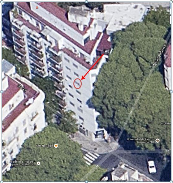
More specifically, it’s the building located at -34.594237, -58.414353. The view is looking roughly due north (Chini will probably tell you it’s looking N at 2.278 degrees or some shit). And I’m guessing the window is on the sixth floor, maybe the seventh. No idea what the  room number is. The building is located in the triangle between Mario Bravo, Soler and De la Carcova streets. It took me about 20 minutes to find the building. Then I spent the next three hours trying to figure out something about the building. Nada. I’m guessing it’s an apartment building since there seems to be a bunch of rentals nearby. You can always check out the nearby Lovers and Fuckers, if you’re in the neighborhood.
After having wasted more than a few Saturday afternoons trying to figure out the VFYW contest, I’ve now decided that if I can’t figure out a lead within 1-2 minutes, then I have to get on my life. Sometimes I’ve been able to get the city, but not the building. Other times, I have a gut feeling that I’ve been to the town or city in the picture, but can’t quite figure it out. I nailed #157, but so did everybody else. #177 was especially frustrating since it looked so familiar, I’d recently been on vacation there and had gone to college nearby.
When I looked at this VFYW pic, my immediate reaction was “WTF?”, like usual. But then I noticed the bus and realized that it offered a ton of clues. Sure enough, it lead me to this building.
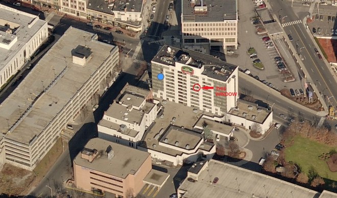
(The above image is actually from a different reader.) Another suspects that “Doug Chini is fuming with boredom.” Let’s see:
To steal a line from Whittier, “it might have been.” If your viewer had waited a few seconds longer to take this week’s image just finding the right city would have been a battle, much less the exact spot. But they didn’t, and that #39 bus passing through center frame means that the Dish staff is gonna be buried under a landslide of responses.
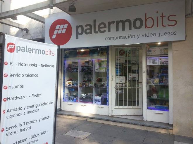
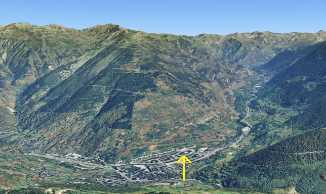
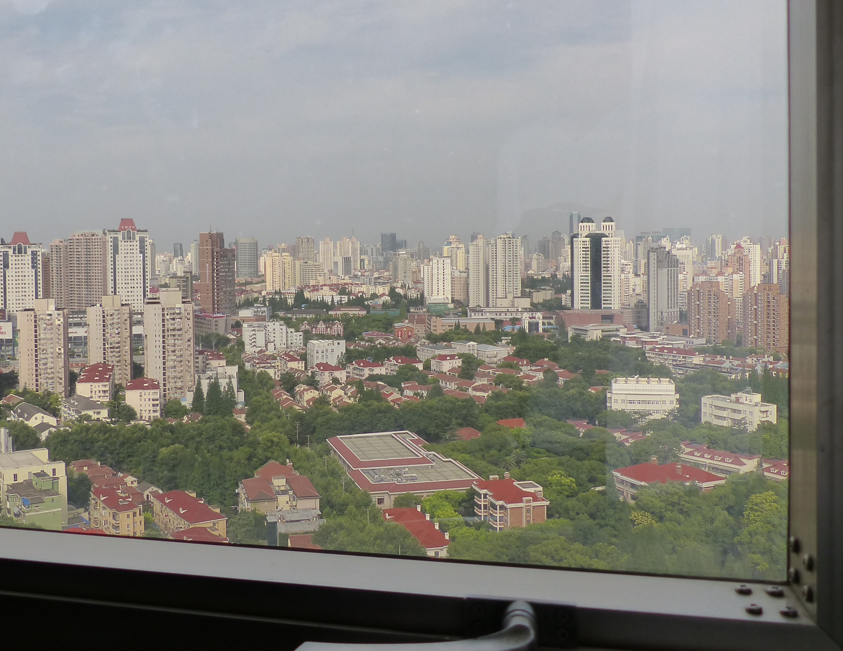
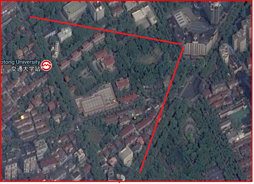
This week’s view comes from Buenos Aires, Argentina. The picture was taken from roughly the fifth floor of a building on the 3500 block of Esquinas Soler and looks almost due north along a heading of 348.3 degrees. Bird’s eye and overhead views are attached along with a shot of the video game store just below your viewer’s window:
Another great entry:
This one gave my roommate and me a good, solid two hours of bonding time. You usually don’t give as many hints as you did here! A full bus number and name, that’s something. He’s been to Argentina, so he noticed the architecture right away, too. From there, it was scouring the bus line for an intersection where the 39 takes a right from a one-way street onto a two-way street. It’s where Av Coronel Diaz meets Soler and Honduras here. The 3500 block of Soler. We haven’t had this much fun together since we used to smoke pot and play frisbee in the park, thank you!
About 95% of the contestants this week correctly answered Buenos Aires, and dozens guessed the right floor in the triangle building at 3594 Soler, where I’m living for two months while Dishing full-time. So picking a winner was tough this week. But the prize goes to one of our favorite new contestants this year, better known as the GIF guy, for his inimitable entry:
The GIF guy, like Chini, has become such a great staple of the window contest that I asked permission to use his real name (since the Dish has a default anonymity policy of course). So welcome Blake Fall-Conroy to the pantheon of the VFYWC. Little surprise that Blake is an artist. Another creative reader wraps up this week’s contest with a short story:
The Chacarita 39
The late afternoon light was fading along Soler street, but enough of it filtered in to softly illuminate the small apartment with the dingy windows on the 6th floor. The low hum of traffic and street chatter drifted up from below and a few birds whistled loudly to each other.
Fernando’s eyes blinked open. What time was it?
He glanced over at the clock by the bed. The numbers were red and blurry, but he could make out 7:32. That couldn’t be right. Had he really slept for 3 hours?
He sat up panicked and looked down at his clothes. He was still wearing the wrinkled khakis and blue t-shirt that he had on in his engineering class that morning. The classes at Palermo were always long and boring and he was still hung over from Chasco’s party. He thought he could get a short nap in before meeting Maricela at the café across the street.
“I’ll give you one last chance,” she had said, sipping her Torrontés, her mischievous eyes sparkling from the blue party lights. “Meet me at six at Nostalgia and we’ll talk about it.” He had grinned stupidly at her as she left the party, and she had smiled back.
Fernando put his head in his hands. How had he let himself sleep through it? Would she still be there?
The answer came from the low rumble of a diesel bus overtaking the clatter of conversations from the café patio. He ran to the window and peered down at the intersection. Through the trees he could see the Chacarita 39 – Maricela’s bus – pulling out from in front of the café. He was too late. He grabbed his phone and snapped a picture as it turned onto Honduras street. The bus faded out of his view, taking Maricela across Buenos Aires and out of his life.
(Archive: Text|Gallery)

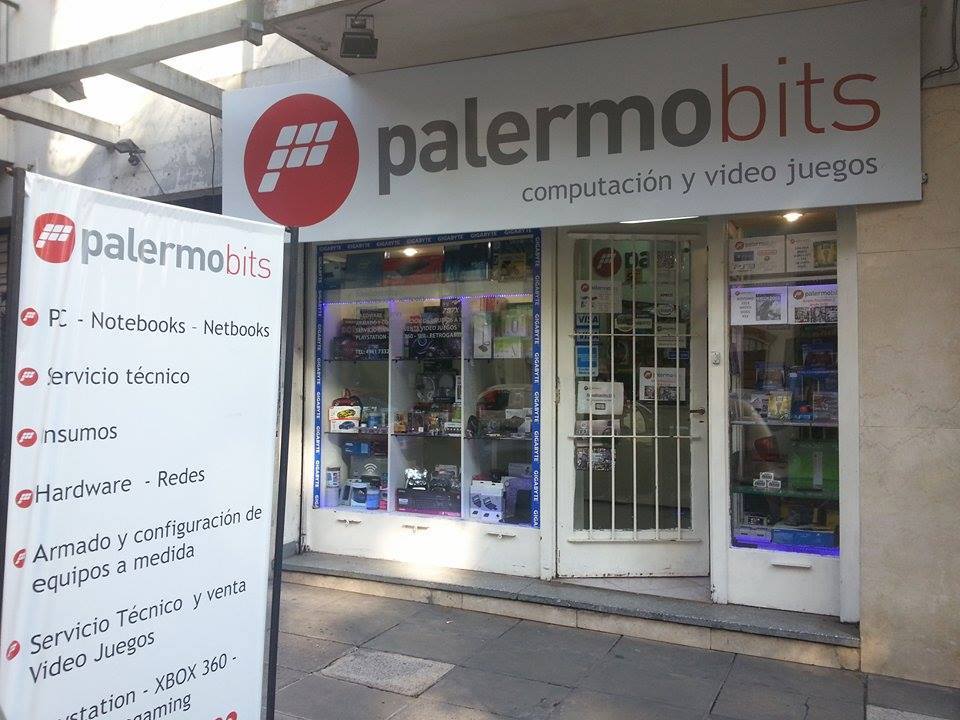
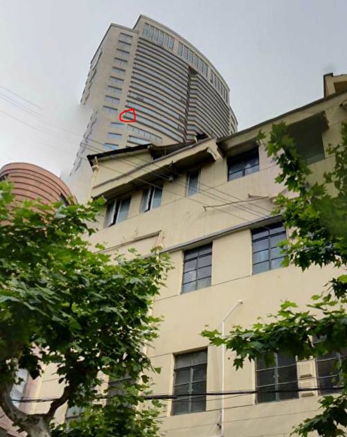
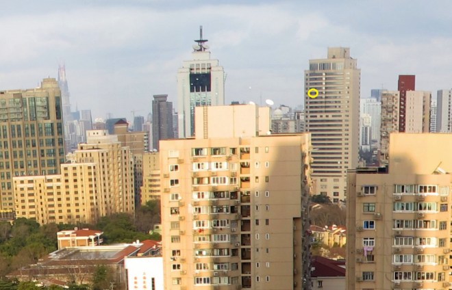
what is up with that yellow box on the side of the building in the foreground that looks like a hand soap dispenser. I am not going to be that person.


